
Where Flight Simulation Enthusiasts Gather from Around the World!
AVSIM Library - Search Results

| Category: Flight Simulator X - Scenery | |
| EPGO Goraszka 2010 - The Airshow Challenge |

|
Images related to this file:
File Description:
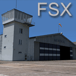
EPGO Goraszka 2010 - The Airshow Challenge is a freeware, extremely detailed scenery of a general aviation airport located 12nm (20km) south-east of Warsaw downtown and Warsaw Frederic Chopin International Airport, Poland. EPGO Goraszka airfield was built in 1994 and currently belongs to General Aviation company, which offers aero-taxi flights, air transport and special flights (air photo, patrol) and airport services. The airport has a 800m-long runway and a lightened helipad, which can be used by helicopters up to 5700kg weight. General Aviation's fleet includes Antonov AN-2, PZL-104 Wilga 80, Bell 407 and 427. Since 1996 the International Air Picnic Goraszka is organized every year by "Polish Eagles" Foundation created on initiative of Zbigniew Niemczycki.
The scenery is equipped with an automatic installer. Currently we support a safe, manual way of adding new sceneries to Scenery Library in Flight Simulator. This is just one thing users need to do for themselves. Detailed instructions will be given during the installation process.
Scenery features:
-Compatible with FSX only
-Highest level of accuracy in geographic positioning, modelling and texturing
-Incredibly high quality photoreal textures of all airport buildings. Textures are based on over 300 real world -photographs made for this project.
-Hundrieds of 3D objects like tents, exhibitions, airport buildings and surrounding buildings
-Life in the airport: people and cars will enchance your feelings
-AI traffic, animations and effects, designed specifically for FSX
-Some buildings include interior (control tower)
-High quality aerial photos of the airport surrondings (5 seasons + night) with autogen and water mask
-Ultra high quality aerial photos of the airport (with seasons)
-Plain airport scenery with no airshow objects available too (details in the manual)
-Product includes manual and airport charts in PDF format
EPGO Goraszka 2010 - The Airshow Challenge scenery is compatible with almost every payware add-on, including Ultimate Terrain Eastern Europe and Warsaw Photo Scenery by Simdesign. Scenery by Drzewiecki Design - www.drzewiecki-design.net .
| Filename: | EPGO_Goraszka_2010__The_Airshow_Challenge.zip |
| License: | Freeware |
| Added: | 16th July 2010, 12:31:42 |
| Downloads: | 4,712 |
| Author: | Drzewiecki Design - Stanislaw Drzewiecki, Jakub Paczek |
| Size: | 237.18 MB |
| Category: Flight Simulator 2004 - Scenery | |
| Anticosti Island in Quebec Canada |
|
Images related to this file:
File Description:
Anticosti Island is in the Gulf of St Lawrence, around 25 miles off the Quebec mainland coast. It is some 40 miles wide and 130 miles long on an east west axis. There are few urban areas and only one that can be described as a small town, namely Port Menier at the western end of the southern coast, with a population of under 1,000. There is a ferry service to the harbour. The airport, Port Menier CYPN, is around 3 miles northeast of the town, with an asphalt runway aligned 11-28, 4,875 feet long and 150 feet wide with PAPI at each end. In 2010 (the approximate date of this scenery) a gravel runway was still visible at the eastern end of the field. This was no longer in use by 2010, except perhaps by small planes on skis in the winter. The island, with its small population, small urban area, and no industry other than logging, has as a result a mainly undisturbed wildlife population. This has made deer hunting and fishing the main tourist activities, with one company (called Safari) having an exclusive licence to exploit large areas of mountains and rivers. Planeloads of hunters and fishermen are flown in on chartered Nolinor Aviation planes from the south. There are a further two airfields in the eastern end of the island, and in 2010 Rivere-Aux-Saumons CTH7 had a 5,500 feet gravel runway, linked by road to a lodge area at the mouth of the river. This is the only lodge area that I have been able to locate, but there are others. To the south Riviere Bell CRB5 had at that time a gravel runway that was 3,000 feet long. This has been lengthened since then and both runways were recently (2021) asphalted. If you find an error email me please, and note that my email address has been changed to rogwens at Gmail dot com.
| Filename: | Anticosti_Island_in_Quebec_Canada.zip |
| License: | Freeware, limited distribution |
| Added: | 31st July 2021, 18:23:40 |
| Downloads: | 80 |
| Author: | Roger Wensley |
| Size: | 11.78 MB |
| Category: Flight Simulator 2004 - Scenery | |
| EPGO Goraszka 2010 - The Airshow Challenge |
|
Images related to this file:
File Description:
EPGO Goraszka 2010 - The Airshow Challenge is a freeware, extremely detailed scenery of a general aviation airport located 12nm (20km) south-east of Warsaw downtown and Warsaw Frederic Chopin International Airport, Poland. EPGO Goraszka airfield was built in 1994 and currently belongs to a General Aviation company, which offers aero-taxi flights, air transport and special flights (air photo, patrol) and airport services. The airport has a 800m-long runway and a lightened helipad, which can be used by helicopters of up to 5700kg weight. General Aviation's fleet includes Antonov AN-2, PZL-104 Wilga 80, Bell 407 and 427. Since 1996 the International Air Picnic Goraszka is organized every year by the "Polish Eagles" foundation created on initiative of Zbigniew Niemczycki.
The scenery is equipped with an automatic installer. Currently we support a safe, manual way of adding new sceneries to the Scenery Library in Flight Simulator. This is just one thing users need to do for themselves. Detailed instructions will be given during the installation process.
Scenery features:
-Compatible with FS2004 only
-Highest level of accuracy in geographic positioning, modeling and texturing
-Incredibly high quality photoreal textures of all airport buildings. Textures are based on over 300 real world -photographs made for this project.
-Hundreds of 3D objects like tents, exhibitions, airport buildings and surrounding buildings
-Life in the airport: people and cars will enhance your feelings
-AI traffic, animations and effects, designed specifically for FS2004
-Some buildings include interior (control tower)
-High quality aerial photos of the airport surroundings (5 seasons + night) with autogen and water mask
-Ultra high quality aerial photos of the airport (with seasons)
-Plain airport scenery with no airshow objects available too (details in the manual)
-Product includes manual and airport charts in PDF format
EPGO Goraszka 2010 - The Airshow Challenge scenery is compatible with almost every payware add-on, including Ultimate Terrain Eastern Europe and Warsaw Photo Scenery by Simdesign.
Scenery by Drzewiecki Design - www.drzewiecki-design.net
| Filename: | EPGO_Goraszka_2010__The_Airshow_Challenge.zip |
| License: | Freeware |
| Added: | 14th July 2010, 09:49:07 |
| Downloads: | 3,752 |
| Author: | Drzewiecki Design - Stanislaw Drzewiecki, Jakub Paczek |
| Size: | 132.03 MB |
| Category: Flight Simulator 2004 - Scenery | |
| Pemberton CYPS in British Columbia Canada |
|
Images related to this file:
File Description:
Pemberton is a small village in the Coast Mountains of British Columbia, with a permanent population of under 3,000 and reliant on logging and increasing tourism. It is around 40 miles north of Squamish and 15 miles north of Whistler and the flight north is best described as scenic. The Nairn Falls, a scenic attraction for tourists, are close by. The runway is 3,920 feet of asphalt aligned 06-24, between and close to the join of the Lillooet River and the Green River. The airfield buildings are to the north of the runway, and at the eastern end is a Fire Base for the expected summer forest fires. To the south and west is the Pemberton Golf Course. All the buildings are replicated, and once again this is not an airport, it is an airfield without any lighting and typical of my future posts which are updated versions of airfield scenery made some time ago and not posted. This one is probably more intricate than most that will follow. The lack of lighting is actually very sensible as landing in the mountains in the dark..... Gun Lake is included here, but not for regular use as it is a deserted dirt strip 40 miles to the north that was once used for fire fighting and there is nothing to see. Just a part of the scenery in this area of BC. If you want to follow this trip on Google Earth the next stop is Cache Creek. If you find a defect, email me. Do not email me about the strange doors to the front of the Blackcomb hangar. I was surprised when I saw it and then discovered that the "doors" are actually flexible curtains that are rolled up and down and if rolled down too far...
I have the ok to use the Bell 212 CCG helicopter as a scenery object, but not to post the entire object library of the Red Deer CYQF scenery; if you have the scenery it should show up here.
| Filename: | Pemberton_CYPS_in_British_Columbia_Canada.zip |
| License: | Freeware, limited distribution |
| Added: | 17th November 2020, 17:29:13 |
| Downloads: | 110 |
| Author: | Roger Wensley |
| Size: | 16.18 MB |
| Category: Flight Simulator 2004 - Scenery | |
| Anticosti Island in Quebec Canada |
|
Images related to this file:
File Description:
Anticosti Island is in the Gulf of St Lawrence, around 25 miles off the Quebec mainland coast. It is some 40 miles wide and 130 miles long on an east west axis. There are few urban areas and only one that can be described as a small town, namely Port Menier at the western end of the southern coast, with a population of under 1,000. There is a ferry service to the harbour.
The airport, Port Menier CYPN, is around 3 miles northeast of the town, with an asphalt runway aligned 11-28, 4,875 feet long and 150 feet wide with PAPI at each end. In 2010 (the approximate date of this scenery) a gravel runway was still visible at the eastern end of the field. This was no longer in use by 2010, except perhaps by small planes on skis in the winter.
The island, with its small population, small urban area, and no industry other than logging, has as a result a mainly undisturbed wildlife population. This has made deer hunting and fishing the main tourist activities, with one company (called Safari) having an exclusive licence to exploit large areas of mountains and rivers. Planeloads of hunters and fishermen are flown in on chartered Nolinor Aviation planes, landing at CYPN. There are a further two airfields in the eastern end of the island, and in 2010 Rivere-Aux-Saumons CTH7 had a 5,500 feet gravel runway, linked by road to a lodge area at the mouth of the river. This is the only lodge area that I have been able to locate, but there are others. To the south Riviere Bell CRB5 had at that time a gravel runway that was 3,000 feet long. This has been lengthened since then and both runways were recently (2021) asphalted.
If you find an error email me please, and note that my email address has been changed to rogwens at Gmail dot com. The reason I am posting this now is that I discovered that my original post ended up in MSFS Original Aircraft instead of in FS2004 Scenery. Ooops!
| Filename: | Anticosti_Island_in_Quebec_Canada.zip |
| License: | Freeware, limited distribution |
| Added: | 28th January 2022, 17:39:46 |
| Downloads: | 121 |
| Author: | Roger Wensley |
| Size: | 11.78 MB |
© 2001-2026 AVSIM Online
All Rights Reserved
Privacy Policy |