
Where Flight Simulation Enthusiasts Gather from Around the World!
AVSIM Library - Search Results

| Category: Flight Simulator 2004 - Aircraft Repaints, Textures and Modifications | |
| Everts Air Cargo Embraer EMB-120RT (N1110J) |

|
Images related to this file:
File Description:

Everts Air Cargo flies an eclectic fleet of aircraft providing cargo services throughout Alaska. Among those aircraft are 2 cargo configured EMB-120RT's, one being this one bearing registration N1110J. Everts Air Cargo was formed in 1995 as a FAA Part 121 certificated cargo airline. Everts Air Cargo is based in Fairbanks Alaska, but all scheduled flights are operated out of Anchorage, Alaska where mail and the majority of freight are received. Everts provides scheduled freight service to 12 major hubs in Alaska as well as seasonal service to Deadhorse. Everts also offers charter and flag stop services to any city or village in Alaska where suitable runway conditions exist. The fuselage and tail textures in this repaint are 32-bit with no-mips. I want to say a special thank you to Steve Lewis for inspiring and doing the quality assurance on this repaint.
| Filename: | Everts_Air_Cargo_Embraer_EMB120RT_N1110J.zip |
| License: | Freeware, limited distribution |
| Added: | 16th December 2010, 23:27:46 |
| Downloads: | 1,124 |
| Author: | Jeffrey S. Bryner / Erick Cantu, Daniel Halpern, Steve Drabek, Adriano Martoni |
| Size: | 6.11 MB |
| Category: Flight Simulator 2004 - Scenery | |
| Ninoy Aquino Intl. Airport Scenery (RPLL) |
|
File Description:
FS2004 Ninoy Aquino Int'l Airport Scenery, v2.0. The Ninoy Aquino Int'l Airport is located in Manila, the capital city of the Philippines. Experience the most realistic replica of the Ninoy Aquino Int'l. Developed by the Philippine Flightsimmers Group (PFSG), users can be sure of true accuracy in the scenery comparable to the real counterpart. For more than a year in development, this scenery features new, custom 3D objects--accurate representation of NAIA Terminal 1, PAL Centennial Terminal 2 and the new NAIA Terminal 3. Accurate domestic area with all-customized buildings/hangars, and now includes Manila ACC and Nayong Pilipino. Designed with a user-friendly objective in mind as not to overdo the detail of the scenery that may cause low frame rates. Extensively researched and developed by Peter Binamira and Manny Aquino of the Philippine Flightsimmers Group. This scenery is released as Donationware; see readme for details.
| Filename: | Ninoy_Aquino_Intl_Airport_Scenery_RPLL.zip |
| License: | Shareware, honor system |
| Added: | 3rd January 2004, 19:51:54 |
| Downloads: | 25,137 |
| Author: | Peter Binamira, Manny Aquino |
| Size: | 15.37 MB |
| Category: Flight Simulator X - Scenery | |
| Clark International Airport RPLC - CRK |
|
Images related to this file:
File Description:

FSX scenery for Clark International Airport in Angeles city, Papamga Province , Philippines.
Clark International Airport, formerly the Diosdado Macapagal International Airport (IATA: CRK, ICAO: RPLC), is an airport that is an international gateway to the Philippines within Clark Freeport Zone located 80KM northwest of Manila. The airport is located along the border between the cities of Angeles and Mabalacat in the province of Pampanga and is accessible through the Subic-Clark-Tarlac Expressway, which is connected to the North Luzon Expressway.
Clark serves the general vicinity of central and northern Luzon. The name is derived from the former American Clark Air Force Base which was the largest overseas base of the United States Air Force until it was closed in 1991 and handed over to the Government of the Philippines.
Airlines serving CRK include Air Asia, Asiana, Cebu Pacific, Dragonair, Emirates, Jin Air, Qatar Airways, Tigerair, Fedex and Ups
| Filename: | Clark_International_Airport_RPLC__CRK.zip |
| License: | Freeware, limited distribution |
| Added: | 24th September 2016, 02:43:49 |
| Downloads: | 3,059 |
| Author: | Yann Martineau |
| Size: | 515.94 KB |
| Category: Miscellaneous Files - Demos from Commercial Vendors | |
| Latin VFR Cuzco Photo and Airport Scenery |
|
File Description:
Cuzco or how is also formally known today as “Cusco” is one of the most important cities of Peru and is the historic capital of the Inca empire, it is also the historical capital of Peru designated by its constitution. The city is located in the Andes mountains and its elevation is above 3310 metres or 10860 feet above sea level. The city is nearby the ancient historical symbol of the Incas, Machu Picchu which is about 80 kilometers from Cusco, which became one of the New seven wonders of the world back in 2007.
This airport (SPZO) or (CUZ) has a visibility restriction and only operates during daylight due to the requirement of a visual approach to land. The aircraft operate mainly in one direction of flight in and out of this airport, they land on runway 28 and depart on runway 10. During weather situations in which no visual approach can be made the airport is closed until the weather gets better. No pilot dares to land with an overcast sky into an airport completely surrounded by mountains and no precision guidance navaid in order to assist for the landing. Therefore all landings conducted are SOLELY visual, and strict VFR rules apply. American Airlines (AA) briefly operated in this airport in the late 90’s and the word out there was that they kept doing miss approaches having difficulties with the approach, so it is widely known to be an airport dominated by veterans of the Cuzco approach, mainly Peruvian pilots or Andean pilots that know how difficult it is to have such restrictions. This is certainly the Madeira or the Innsbruck of all Latin American airports, it would be wise to say that this one is harder due to the lack of a precision approach. And by the way the largest aircraft permitted to operate here is a B757-200, however, anything bigger than a B737-200 needs government approval.
| Filename: | Latin_VFR_Cuzco_Photo_and_Airport_Scenery.zip |
| License: | Commercial demo |
| Added: | 2nd May 2009, 01:50:57 |
| Downloads: | 1,200 |
| Author: | LatinVFR |
| Size: | 34.22 MB |
| Category: X-Plane - Scenery | |
| BR PA SBCC - Cachimbo Air Base v1.0.0 |
|
Images related to this file:
File Description:
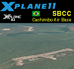
This is an X-Plane 11 and X-Plane 10 scenery package for Cachimbo Airport (ICAO: SBCC, no IATA code), which is the military airport serving "Campo de Provas Brigadeiro Velloso", a large testing and training complex of the Brazilian Armed Forces located in Serra do Cachimbo (English: Smoking pipe Mountains), in the southern part of the state of Pará, Brazil. It is operated by the Brazilian Air Force (FAB). It includes corrected aprons, ramps, gates, taxiways, lighting system, city buildings, ortho-photoscenery for the airfield area, the new apron 2, and (XP11 only) airport ground services (like push back). This scenery was tested and is operational (as of April 16, 2017) in "X-Plane 11.00 RC #1 64 bit", Windows 10 Home. It was also tested and is also operational (as of April 16, 2017) in "X-Plane 10.51 64 bit", Windows 10 Home. Only the default X-Plane 11 libraries, by Laminar Research, are needed. No third party libraries are used.
| Filename: | BR_PA_SBCC__Cachimbo_Air_Base_v100.zip |
| License: | Freeware |
| Added: | 17th April 2017, 06:12:35 |
| Downloads: | 87 |
| Author: | Rui Mesquita |
| Size: | 29.57 MB |
| Category: X-Plane - Scenery | |
| BR CE - SBFZ Pinto Martins Intl v1.2.0 (2017) |
|
Images related to this file:
File Description:

v1.2.0 (Mar/2017). This is an X-Plane 11 and X-Plane 10 scenery package for Pinto Martins – Fortaleza International Airport (IATA: FOR, ICAO: SBFZ), which is the airport serving Fortaleza, in Brazil. It includes corrected aprons, ramps, gates, taxiways, lighting system, photoscenery for the airfield area, the city skyline buildings and (XP11 only) airport ground services (like push back). Four airfields are included, all in the TMA Fortaleza area: (1) SBFZ/FOR - Pinto Martins International Airport v1.2.0, (2) SJDS - Fabrica Fortaleza Private Airport v1.0.1, (3) SJCM - Catuleve Aeronautico Sports Airfield v1.0.0, and (4) SNFF - Feijo Flight School and Private Airfield v1.0.0. This scenery was tested and is operational (as of March 04, 2017) in "X-Plane 11 Public Beta #13 64 bit", Windows 10 Home. It was also tested and is also operational (as of March 04 2017) in "X-Plane 10.51 64 bit", Windows 10 Home. Only the default X-Plane 11 libraries, by Laminar Research, are needed. No third party libraries are used.
| Filename: | BR_CE__SBFZ_Pinto_Martins_Intl_v120_2017.zip |
| License: | Freeware |
| Added: | 4th March 2017, 20:07:21 |
| Downloads: | 128 |
| Author: | Rui Mesquita |
| Size: | 41.64 MB |
| Category: X-Plane - Scenery | |
| Zaragoza AB update - LEZG for XP10.5-11 |
|
Images related to this file:
File Description:
UPDATED version of earlier (Feb. 2017) LEZG AB. All adjusted for use with orthographic and HD material. Extensive Read Me is in the package. However: I used many "Libraries" as defined in the Read Me file to get the best scenery with optimized scaling of objects. Added visual beacons about 20 nm E and W from runways to make it easier to navigate this "rare" airport. Zaragoza city is improved and more "real". I have done all I could to keep frame-rates low (on my NV960: locked to screen refresh always between 50-60 fps) and temperatures low. See the images as well to orient yourself. LEZG comprises 5 platforms and now is expanded with a new engine test plate and a new GA platform. It is a huge airbase with civil part. I am still looking for a good F-18 static model, to replace the F-4's I had to use now.
| Filename: | Zaragoza_AB_update__LEZG_for_XP10511.zip |
| License: | Freeware |
| Added: | 9th March 2017, 18:45:18 |
| Downloads: | 238 |
| Author: | John v. Kampen |
| Size: | 18.96 MB |
| Category: X-Plane - Scenery | |
| BR PA SBMA - Maraba Airport v1.0.0 |
|
Images related to this file:
File Description:
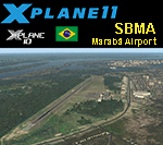
This is an X-Plane 11 and X-Plane 10 scenery package for João Correa da Rocha Airport (IATA: MAB, ICAO: SBMA), which is the airport serving Marabá, Pará, in Brazil. It is operated by Infraero.
It includes corrected aprons, ramps, gates, taxiways, lighting system, city buildings, ortho-photoscenery for the airfield area, and (XP11 only) airport ground services (like push back).
The airport is located 5 km (3 mi) from downtown Marabá. The airport was inaugurated on May 20, 1978. Airlines and destinations include:
- Azul Brazilian Airlines to/from: Belém/SBBE, Carajás/SBCJ
- Gol Airlines to/from: Belém/SBBE, BrasÃlia/SBBR
- LATAM Brasil to/from: Belém/SBBE, BrasÃlia/SBBR
This scenery was tested and is operational (as of January 17, 2018) in "X-Plane 11.11 64 bit", Windows 10 Home. It was also tested and is also operational (as of January 17, 2018) in "X-Plane 10.51 64 bit", Windows 10 Home.
| Filename: | BR_PA_SBMA__Maraba_Airport_v100.zip |
| License: | Freeware |
| Added: | 2nd February 2018, 00:13:33 |
| Downloads: | 83 |
| Author: | Rui Mesquita |
| Size: | 10.8 MB |
| Category: X-Plane - Scenery | |
| BR MS SBPP - Ponta Pora Airport v1.0.0 |
|
Images related to this file:
File Description:
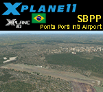
This is an X-Plane 11 and X-Plane 10 scenery package for Ponta Porã International Airport (IATA: PMG, ICAO: SBPP) is the airport serving Ponta Porã, Brazil. It is operated by Infraero.
It includes corrected aprons, ramps, gates, taxiways, lighting system, city buildings, ortho-photoscenery for the airfield area, and (XP11 only) airport ground services (like push back).
The airport is located 4 km (2 mi) from downtown Ponta Porã, as well as from dowtown Pedro Juan Caballeros (in Praguay). The airport was opened on March 11, 1955, and it is dedicated to general aviation. No scheduled flights operate at this airport. It is located right in the border between Brazil and Paraguay.
This scenery was tested and is operational (as of January 21, 2018) in "X-Plane 11.11 64 bit", Windows 10 Home. It was also tested and is also operational (as of January 21, 2018) in "X-Plane 10.51 64 bit", Windows 10 Home.
| Filename: | BR_MS_SBPP__Ponta_Pora_Airport_v100.zip |
| License: | Freeware |
| Added: | 2nd February 2018, 00:18:31 |
| Downloads: | 42 |
| Author: | Rui Mesquita |
| Size: | 10.43 MB |
| Category: Flight Simulator 2004 - AI Flight Plans | |
| Swiss Winter 2005/06 |
|
File Description:
This flight plan is based upon the real-world aircraft rotations for Swiss International and Swiss European for the first week of the Winter schedule (i.e. 31 October-6 November 2005). I have made manual adjustments to the Mondays and Sundays, to make everything fit into one-week patterns, but otherwise the flight plan is painstakingly accurate down to the individual registration numbers. With very few exceptions, all flights are included as are actual charter and positioning flights. I have also included the cargo schedule that MNG flies for Swiss, whereas you can get the Lugano schedule flown by Darwin from several other sources on Avsim. HB-IQH was really in maintenance that week, but I had to make it fly one return flight. Consider getting the approaches into London City (EGLC) that I have rewritten. The default ones are flawed causing AI traffic to arrive too high to make a landing. I shall be posting those shortly.
| Filename: | Swiss_Winter_200506.zip |
| License: | Freeware |
| Added: | 23rd November 2005, 00:03:13 |
| Downloads: | 1,547 |
| Author: | Alexander Michael |
| Size: | 24.57 KB |
© 2001-2026 AVSIM Online
All Rights Reserved
Privacy Policy |