
Where Flight Simulation Enthusiasts Gather from Around the World!
AVSIM Library - Search Results

| Category: Flight Simulator X - Scenery | |
| Mesh South America / MeSA A01 |

|
File Description:
FSX Mesh South America Project:
This terrain mesh file is a part of a whole project covering all the Continent of South America and some islands, divided in tiles identified in a map by its column (letters) and rows (numbers).
Those files were multi-LOD compiled from 90m SRTM2 source data, reprocessed with 3DEM to remove voids and spikes, providing a 76.4m (LOD9) horizontal resolution topography intended for use only in FSX updated with SP1.
Although not well documented, to improve performance, the updated FSX loads DEM files in threads and only the closer terrain (about 5 NM from the point of view)is rendered in high detail, while at far distances FSX shows up its default low resolution mesh, when there is not a third part terrain mesh compiled in all others intermediate level of details (multi-LOD).
THIS FILE: FSX_MeSA_A01
(Column A x Row 01)
This file covers the area inside the boundaries:
N = 16º 52,5' N; S = 11º 15' N;
W = 90º 0' W; E = 82º 30' W;
AUTHORS:
Hely Heck Junior - Magrao ( [email protected] )
and Jose Lobo ( [email protected] )
TerraBrasilis: www.terra-brasilis.org
| Filename: | Mesh_South_America__MeSA_A01.zip |
| License: | Freeware |
| Added: | 11th June 2007, 00:03:00 |
| Downloads: | 1,958 |
| Author: | Hely Heck Jr. and José Lôbo |
| Size: | 49.55 MB |
| Category: Flight Simulator X - Scenery | |
| Mesh South America / MeSA A03 |
|
File Description:
FSX Mesh South America Project:
This terrain mesh file is a part of a whole project covering all the Continent of South America and some islands, divided in tiles identified in a map by its column (letters) and rows (numbers).
Those files were multi-LOD compiled from 90m SRTM2 source data, reprocessed with 3DEM to remove voids and spikes, providing a 76.4m (LOD9) horizontal resolution topography intended for use only in FSX updated with SP1.
Although not well documented, to improve performance, the updated FSX loads DEM files in threads and only the closer terrain (about 5 NM from the point of view) is rendered in high detail, while at far distances FSX shows up its default low resolution mesh, when there is not a third part terrain mesh compiled in all others intermediate level of details (multi-LOD).
THIS FILE:
FSX_MeSA_A03
Column A x Row 03
This file covers the area inside the boundaries:
N = 5º 37,5' N; S = 0º 0' S;
W = 90º 0' W; E = 82º 30' W;
AUTHORS:
Hely Heck Junior - Magrao ( [email protected] )
and José Lôbo ( [email protected] )
TerraBrasilis: www.terra-brasilis.org
| Filename: | Mesh_South_America__MeSA_A03.zip |
| License: | Freeware |
| Added: | 11th June 2007, 00:02:40 |
| Downloads: | 1,419 |
| Author: | Hely Heck Jr. and José Lôbo |
| Size: | 1.52 MB |
| Category: Flight Simulator X - Scenery | |
| Mesh South America / MeSA B06 |
|
File Description:
FSX Mesh South America Project:
This terrain mesh file is a part of a whole project covering all the Continent of South America and some islands, divided in tiles identified in a map by its column (letters) and rows (numbers).
Those files were multi-LOD compiled from 90m SRTM2 source data, reprocessed with 3DEM to remove voids and spikes, providing a 76.4m (LOD9) horizontal resolution topography intended for use only in FSX updated with SP1.
Although not well documented, to improve performance, the updated FSX loads DEM files in threads and only the closer terrain (about 5-10 NM from the point of view) is rendered in high detail, while at far distances FSX shows up its default low resolution mesh, when there is not a third part terrain mesh compiled in all others intermediate level of details (multi-LOD).
THIS FILE:
FSX_MeSA_B06 (Column B x Row 06)
This file covers the area inside the boundaries:
N = 11º 15' S; S = 16º 52,5' S;
W = 82º 30' W; E = 75º 0' W;
AUTHORS:
Hely Heck Junior - Magrao ( [email protected] )
and Jose Lobo ( [email protected] )
TerraBrasilis: www.terra-brasilis.org
| Filename: | Mesh_South_America__MeSA_B06.zip |
| License: | Freeware |
| Added: | 11th June 2007, 22:10:10 |
| Downloads: | 1,422 |
| Author: | Hely Heck Jr. and José Lôbo |
| Size: | 12.99 MB |
| Category: Flight Simulator X - Scenery | |
| Mesh South America / MeSA D09 |
|
File Description:
FSX Mesh South America Project:
This terrain mesh file is a part of a whole project covering all the Continent
of South America and some islands, divided in tiles identified in a map by its
column (letters) and rows (numbers).
Those files were multi-LOD compiled from 90m SRTM2 source data, reprocessed
with 3DEM to remove voids and spikes, providing a 76.4m (LOD9) horizontal
resolution topography intended for use only in FSX updated with SP1.
Although not well documented, to improve performance, the updated FSX loads DEM
files in threads and only the closer terrain (about 5-10 NM from the point of view)
is rendered in high detail, while at far distances FSX shows up its default low
resolution mesh, when there is not a third part terrain mesh compiled in all
others intermediate level of details (multi-LOD).
THIS FILE:
FSX_MeSA_D09 (Column D x Row 09)
covers the area inside the boundaries:
N = 33º 45' S; S = 39º 22.5' S;
W = 67º 30' W; E = 60º 0' W;
AUTHORS:
Hely Heck Junior - Magrao ( [email protected] )
and Jose Lobo ( [email protected] )
TerraBrasilis: www.terra-brasilis.org
| Filename: | Mesh_South_America__MeSA_D09.zip |
| License: | Freeware |
| Added: | 13th June 2007, 12:36:59 |
| Downloads: | 1,259 |
| Author: | Hely Heck Jr. and José Lôbo |
| Size: | 52.3 MB |
| Category: Flight Simulator X - Scenery | |
| Mesh South America / MeSA D13 |
|
File Description:
FSX Mesh South America Project:
This terrain mesh file is a part of a whole project covering all the Continent
of South America and some islands, divided in tiles identified in a map by its
column (letters) and rows (numbers).
Those files were multi-LOD compiled from 90m SRTM2 source data, reprocessed
with 3DEM to remove voids and spikes, providing a 76.4m (LOD9) horizontal
resolution topography intended for use only in FSX updated with SP1.
Although not well documented, to improve performance, the updated FSX loads DEM
files in threads and only the closer terrain (about 5-10 NM from the point of view)
is rendered in high detail, while at far distances FSX shows up its default low
resolution mesh, when there is not a third part terrain mesh compiled in all
others intermediate level of details (multi-LOD).
THIS FILE:
FSX_MeSA_D13 (Column D x Row 13)
covers the area inside the boundaries:
N = 50º 37.5' S; S = 56º 15' S;
W = 67º 30' W; E = 60º 0' W;
AUTHORS:
Hely Heck Junior - Magrao ( [email protected] )
and Jose Lobo ( [email protected] )
TerraBrasilis: www.terra-brasilis.org
| Filename: | Mesh_South_America__MeSA_D13.zip |
| License: | Freeware |
| Added: | 13th June 2007, 16:38:14 |
| Downloads: | 1,124 |
| Author: | Hely Heck Jr. and José Lôbo |
| Size: | 4.79 MB |
| Category: Flight Simulator X - Scenery | |
| Mesh South America / MeSA D12 |
|
File Description:
FSX Mesh South America Project:
This terrain mesh file is a part of a whole project covering all the Continent
of South America and some islands, divided in tiles identified in a map by its
column (letters) and rows (numbers).
Those files were multi-LOD compiled from 90m SRTM2 source data, reprocessed
with 3DEM to remove voids and spikes, providing a 76.4m (LOD9) horizontal
resolution topography intended for use only in FSX updated with SP1.
Although not well documented, to improve performance, the updated FSX loads DEM
files in threads and only the closer terrain (about 5-10 NM from the point of view)
is rendered in high detail, while at far distances FSX shows up its default low
resolution mesh, when there is not a third part terrain mesh compiled in all
others intermediate level of details (multi-LOD).
THIS FILE:
FSX_MeSA_D12 (Column D x Row 12)
covers the area inside the boundaries:
N = 45º 0' S; S = 50º 37.5' S;
W = 67º 30' W; E = 60º 0' W;
AUTHORS:
Hely Heck Junior - Magrao ( [email protected] )
and Jose Lobo ( [email protected] )
TerraBrasilis: www.terra-brasilis.org
| Filename: | Mesh_South_America__MeSA_D12.zip |
| License: | Freeware |
| Added: | 13th June 2007, 15:28:04 |
| Downloads: | 1,146 |
| Author: | Hely Heck Jr. and José Lôbo |
| Size: | 5.54 MB |
| Category: Flight Simulator X - Scenery | |
| Mesh South America / MeSA A02 |
|
File Description:
FSX Mesh South America Project:
This terrain mesh file is a part of a whole project covering all the Continent of South America and some islands, divided in tiles identified in a map by its column (letters) and rows (numbers).
Those files were multi-LOD compiled from 90m SRTM2 source data, reprocessed with 3DEM to remove voids and spikes, providing a 76.4m (LOD9) horizontal resolution topography intended for use only in FSX updated with SP1.
Although not well documented, to improve performance, the updated FSX loads DEM files in threads and only the closer terrain (about 5 NM from the point of view) is rendered in high detail, while at far distances FSX shows up its default low resolution mesh, when there is not a third part terrain mesh compiled in all others intermediate level of details (multi-LOD).
THIS FILE:
FSX_MeSA_A02
Column A x Row 02
This file covers the area inside the boundaries:
N = 11º 15' N; S = 5º 37,5' N;
W = 90º 0' W; E = 82º 30' W;
AUTHORS:
Hely Heck Junior - Magrao ( [email protected] )
and Jose Lobo ( [email protected] )
TerraBrasilis: www.terra-brasilis.org
| Filename: | Mesh_South_America__MeSA_A02.zip |
| License: | Freeware |
| Added: | 11th June 2007, 00:02:15 |
| Downloads: | 1,592 |
| Author: | Hely Heck Jr. and José Lôbo |
| Size: | 10.95 MB |
| Category: Flight Simulator X - Scenery | |
| Goma Intl (FZNA) DRC and Gisenyi (HRYG) Rwanda |
|
Images related to this file:
File Description:
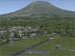
This project includes the neighboring Goma Intl (FZNA) and Gisenyi (HRYG) airports. After Goma's only runway was severely damaged by the eruption of Mount Nyiragongo in 2002, the runway, originally 3000m long, was reduced to 1800m of serviceable pavement after lava flowed onto the northern part runway and through the city center. In 2013, German NGO Welthungerhilfe ("World Hunger Aid") signed a contract to rehabilitate 500m of runway damaged by the lava flow. Goma resumed scheduled international flights in 2015, and this project reflects the airport as of March 2016, with runway 18/36 renumbered to 17/35. SRTMGL1 (30m) mesh brings the volcanoes in the area into much greater detail. This scenery is complimented by the Kigali Intl (HRYR) scenery (FSX_HRYR_Kigali_2016.zip).
Updates were created or rebuilt in a manner which carefully aligns airport data with current satellite imagery. Scenery was created using Airport Design Editor X v1.70.6042, SBuilderX 3.13, and the FSX Object Placement Tool. Scenery objects were added and modified from stock FSX scenery to resemble as closely as possible the actual airports. The FSX apron lights included are from the set created by Jim Dhaenens.
| Filename: | Goma_Intl_FZNA_DRC_and_Gisenyi_HRYG_Rwanda.zip |
| License: | Freeware |
| Added: | 4th August 2016, 21:11:20 |
| Downloads: | 2,276 |
| Author: | Carlyle Sharpe |
| Size: | 5.25 MB |
| Category: Flight Simulator X - Scenery | |
| Murray river and SE Victoria v2 for ORBX v2. YRIO Robinvale YBRN Balranald YDLQ Deniliquin YLEG Leongatha YYRM Yarram |
|
Images related to this file:
File Description:
'Murray and SE Victoria v2' is made to match ORBX Australia v2 scenery. Use 'Murray + SE Victoria airports' for ORBX v1 or no ORBX. There are 5 airports. 3 airports near the Murray river in Victoria and NSW - YRIO Robinvale, YBRN Balranald, YDLQ Deniliquin. 2 airports in SE Victoria - YLEG Leongatha, YYRM Yarram. ORBX has done these as they have done every airport included with FSX in Australia to a reasonable standard. If I had not already done them for ORBX V1 I would not have bothered. However these are better than ORBX because the surroundings have been modified to match real life. Towns have been added or shifted. Forests cut down or added. Race courses, sewage treatment ponds and other stuff added. Local obstacles (towers etc) added. There are Included are 2 AI traffic files that cover the airports. These files are for Flight Simulator X. Made using Airport Design Editor using some objects borrowed from Robert Budd's excellent Baccus Marsh and 'Static aircrafts' by Jean-Pierre Fillion. REQUIRED The scenery is designed to interface with ORBX FTX_AU V2 scenery for Australia (payware).
| Filename: | Murray_river_and_SE_Victoria_v2_for_ORBX_v2_YRIO_R.zip |
| License: | Freeware |
| Added: | 15th December 2019, 19:06:10 |
| Downloads: | 315 |
| Author: | Colin Jeffery |
| Size: | 10.06 MB |
| Category: Flight Simulator 2004 - Scenery | |
| Durban Island CWFB FOX-E DEW line station in Nunavut, Canada |
|
Images related to this file:
File Description:
Durban Island is 40 miles north of Cape Dyer on the southeast corner of Baffin Island, and around 60 miles southeast of Qikiqtarjuaq (known as Broughton until recently). Sitting on the top of the island is FOX-E, an intermediate station that was part of the DEW line. There is no runway (and once you have seen the island you will know why) and the station and its (usually) five man crew were supported by helicopter flights from Cape Dyer. The main feature is a 300' high mast, topped by comms gear to link both to Broughton to the north and Cape Dyer to the south. There was only one really habitable building, 80' x 30' in round figures, and this contained the generators, technical spaces, sleeping areas, kitchen, mess, and showers etc. There were also what were known as Anderson shelters, originally put up to house the construction crew and used in the summer for any maintenance people who visited for short periods. There was also a garage for a snow cat and tanks for fuel. And a view.
This post also includes new bgls for Cape Dyer to provide the 300' tower there too.
| Filename: | Durban_Island_CWFB_FOXE_DEW_line_station_in_Nunavu.zip |
| License: | Freeware, limited distribution |
| Added: | 1st July 2011, 22:11:33 |
| Downloads: | 313 |
| Author: | Roger Wensley |
| Size: | 1.87 MB |
© 2001-2026 AVSIM Online
All Rights Reserved
Privacy Policy |