
Where Flight Simulation Enthusiasts Gather from Around the World!
AVSIM Library - Search Results

| Category: Flight Simulator X - Utilities | |
| Taxi Navigation (+Destination Weather Reporter) for FSX/FS9 V1.0 |

|
Images related to this file:
File Description:

Do you prepare airport charts of every airport you visit, or just follow the progressive taxi to do taxiing?
This utility will make taxiing easy and realistic by providing simple taxi navigation information in text.
While taxiing, press "Ctrl + Shift + X", then taxi navigation information will be displayed.
It includes current taxiway name, intersecting taxiways' name and distance
(e.g. "On R7 : R2 (250m), R1 (643m), A (748m), A7 (748m)").
And one more thing, it also provides destination weather report.
It can be very helpful to set up exact T/D(Top of Descent), by assuming expected runway with wind information.
Enter destination airport before flight, and press "Ctrl + Shift + W" while flying,
then destination weather information will be displayed.
It looks like METAR and includes wind direction and speed, visibility, temperature, dew point and pressure
(e.g. "RKPK 29403KT 47SM 32/23 1010mb").
| Filename: | Taxi_Navigation_Destination_Weather_Reporter_for_F.zip |
| License: | Freeware |
| Added: | 3rd August 2012, 06:47:24 |
| Downloads: | 2,940 |
| Author: | Dongjin Shin |
| Size: | 4.88 MB |
| Category: Flight Simulator X - Original Aircraft | |
| Bristol F2B Mk.1 Part 1 |
|
File Description:
Flight Simulator X version of the Bristol Fighter Mk.1 or 'Biff' as it was called by its crews in WW1. This file is part 1 of a 4 part download and contains visual models and textures depicting 3 aircraft with the earlier short form exhausts. No other downloads are required to make this functional. The other 3 downloads are optional variants. This aircraft was modeled using 3DS Max 8.0 and compiled using FSX SDK tools and will only work in FSX or higher. It is NOT compatible with FS2004. The aircraft makes full use of FSX materials and also features skinned animated crew members in the external model. It also features a detailed virtual cockpit. All instruments, levers and selectors are modeled in the 3D model. It does not use the FSX gauge system and there is NO 2D cockpit.
| Filename: | Bristol_F2B_Mk1__Part_1.zip |
| License: | Freeware, limited distribution |
| Added: | 2nd February 2007, 03:22:25 |
| Downloads: | 7,365 |
| Author: | Robert Bruce |
| Size: | 22.04 MB |
| Category: X-Plane - Aircraft Repaints, Textures and Modifications | |
| Mitsubishi MU-2 (N316PR) |
|
Images related to this file:
File Description:
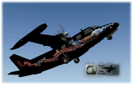
This is a repaint, made for the X-Scenery Mitsubishi MU-2 (payware aircraft add-on).
It depicts the N316PR wich crashed tragically on the 25th of June 2006.
I added normal-files (with specular-layers) wich contain custom-made effects (specular regulated gloss).
These custom normals are part of the livery allthough they can be used for other liveries as well.
Please read the enclosed N316PR_Readme PDF carefully. Use a text editor e.g. Wordpad for editing the OBJ files.
Make sure to install the new normal files from MU-2_normals.zip if you already downloaded this livery (they replace the normals in MU-2_N316PR.zip) and all windows will have gloss again. ( sorry for the inconvenience)
The version V2 includes this new normals.
Questions, or need help, please mail me. Enjoy, Leen de Jager www.flybike-paints.nl
| Filename: | Mitsubishi_MU2_N316PR.zip |
| License: | Freeware, limited distribution |
| Added: | 21st June 2013, 21:05:30 |
| Downloads: | 43 |
| Author: | Leen "Flybike" de Jager |
| Size: | 10.64 MB |
| Category: Flight Simulator X - Scenery | |
| Grise Fiord Airport CYGZ |
|
File Description:
Grise Fiord, NWT Canada scenery - CYGZ (FSX).
This is a fictitious rendition of the actual and VERY REMOTE Airport at Grise Fiord in the Canadian NWT - CYGZ.
Grise Fiord is the most northerly community in Canada.
Only operators with considerable experience should use this aerodrome at all. Bring your Twin Otter. There are places to fly your helocopters too. (Explore the oil rigs or see if you can land on one of the destroyers passing by).
See the whales!
See: http://www.copanational.org/PlacesToFly/airport_view.php?pr_id=13&ap_id=288
For great photo's of the area: http://www.arcticcircle.ca/Baffin/Grise/
Virtual improvements have finally come to this area where the ice never melts.
This is freeware. I hope you enjoy it.
Designed with the FS X Sdk Scenery function of the Mission builder and the Abacus Scenery shortcut tool.
This scenery is frame rate friendly.
| Filename: | Grise_Fiord_Airport_CYGZ.zip |
| License: | Freeware |
| Added: | 26th January 2007, 02:37:13 |
| Downloads: | 1,520 |
| Author: | Bob Caparoula |
| Size: | 2.47 MB |
| Category: Miscellaneous Files - General Utilities | |
| Wx2pfpx v2.6.4 |
|
Images related to this file:
File Description:
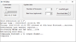
A simple weather data provider for the discontinued Professional Flight Plan X software. The script fetches raw weather data, METAR and TAF data from the NOAA, US national weather service, which is then compiled to a single file that can be imported in PFPX. More than 15000 reference stations (airports) from PFPX are used and wind/temperature data is provided for each of them. When available, METAR and TAF data is also provided for more than 5000 airports. The original data source is updated 4 times a day, and can provide forecasts for every 3 following hours up to 16 days. *** A new script can trigger antivirus analysis as it's unknown, you can ignore it.*** V2: Great precision improvement, possibility of importing the whole NOAA dataset grid, a bit of documentation. V2.6: Repaired due to API change.
| Filename: | Wx2pfpx_v264.zip |
| License: | Freeware, limited distribution |
| Added: | 27th September 2025, 15:55:08 |
| Downloads: | 85 |
| Author: | John Smith |
| Size: | 21.97 MB |
| Category: Flight Simulator X - Scenery | |
| Victoria International Airport (CYYJ) |
|
File Description:
This airport was made using Airport Design Editor. Victoria International Airport is an airport located in Victoria, British Columbia. It has scheduled airline flights for a few airlines. I replaced all the default buildings and put more accurate ones. I also made the main terminal with two jetways. I put the genaral aviation and the terminal in the correct locations. At the genaral aviation, I put static aircraft and aircraft hangers. If you choose to start at the DOCK gate, you will start off in the hanger. To the west, I put helipads that are used for military. I also put the Aviation Museum that is located to the southeast. I used Google Earth and Bing maps for the airport. Please read the readme for instructions on how to install. This download is for Flight Simulator X only.
| Filename: | Victoria_International_Airport_CYYJ.zip |
| License: | Freeware |
| Added: | 22nd December 2011, 19:57:20 |
| Downloads: | 1,885 |
| Author: | Tyler Lawrence |
| Size: | 6.8 MB |
| Category: Flight Simulator X - Scenery | |
| CYYJ (2017) for FS9, FSX and P3D |
|
Images related to this file:
File Description:

CYYJ (2017), Version 7, is a major upgrade to CYYJ (2014). It portrays the Victoria (British Columbia, Canada) International Airport (CYYJ), aviation museum, Pat Bay floatplane base (CAP5) and Coast Guard station, and nearby industrial park as they appeared in early 2017 - as well as a host of static aircraft. It is fully compatible with Victoria+ (both FS2004 And FSX versions), Ultimate Terrain Canada/Alaska for FS2004 and Ultimate Terrain X - Canada for FSX, ORBX's FTX NA Blue and other FS9 road and shoreline upgrades for the area. CYYJ (2017) includes aircraft and traffic files for a realistic AI scenario other than scheduled airline operations. (Use BC Regional AI - also available from this file library - for scheduled traffic).
Version 7 adds all the recent major new construction and apron expansion at CYYJ, and includes a greater level of detail in many areas.
| Filename: | CYYJ_2017__for_FS9_FSX_and_P3D.zip |
| License: | Freeware, limited distribution |
| Added: | 24th May 2017, 18:30:48 |
| Downloads: | 5,985 |
| Author: | Don Grovestine |
| Size: | 118.7 MB |
| Category: Flight Simulator X - Scenery | |
| Alaska Airfields 1.2 |
|
Images related to this file:
File Description:
This is a pack of three airfields in Alaska that I have modified to look more like the real thing. The scenery is made of ready made library buildings and trees, no custom made buildings and stuff, but it's a vast improvement over the stock FSX airfields. The three Airfields are (CSR) Campbell Airfield, (PAUO) Willow Airfield and (PASW) Skwentna Airfield. PLEASE NOTE: These scenerys are made with FSX Acceleration and Flight 1's Ultimate Alaska X installed. I don't know how they look or work without these add-ons. - In version 1.2 I have added a segmented circle to PAUO Willow Airfield (a small make-up), and I have also added a Dock parking space at 2X2 Willow Sea Plane Base, so you may start your flight at the dock with your float or ski plane (a big change). -
| Filename: | Alaska_Airfields_12.zip |
| License: | Freeware |
| Added: | 12th February 2012, 03:46:53 |
| Downloads: | 3,300 |
| Author: | Torbjorn Kuntze |
| Size: | 1.94 MB |
| Category: Flight Simulator X - Scenery | |
| VYYY Yangon Intl Airport Mingaladon V3.0 |
|
File Description:
Yangon International Airport "MINGALADON" in Burma, Myanmar, will be able to accommodate bigger aircrafts and handle more passengers when work on extending its runway and upgrading its facilities is completed. The completion of the runway extension will enable Boeing 747 and Airbus 380 airplanes to use the airport. The work on extending the runway from 8100 feet to 11,200 feet began October 2004. FPS-friendly version 3.0 with already extended runway, taxiways and new taxisigns. First of all we corrected the airport location to the real one. With Myanmar Air Force area, Helipads and even more parkings for civilian airplanes. This scenery was produced based on pictures of satellites. Many Thanks go to the teams of HOUSE-RP in Burma, FSX Planner, SceneGenX, SBuilder X, Open Ports Scanner, AFXBgDownloader, FSUIPC and Google Earth. This scenery is only for FSX, for FS2004 please download vyyy_v2.zip. By HOUSE-RP, Switzerland and Burma
| Filename: | VYYY_Yangon_Intl_Airport_Mingaladon_V30.zip |
| License: | Freeware, limited distribution |
| Added: | 28th October 2007, 19:21:14 |
| Downloads: | 1,228 |
| Author: | HOUSE-RP, Robby Pauletto |
| Size: | 18.29 KB |
| Category: Flight Simulator 2004 - Scenery Design | |
| TDFCalc2004 (Version 3) |
|
File Description:
This package is for FS2004 and FS2002 terrain designers. TDFCalc2004 is made for use with FSUIPC and FS2004. This is a version that includes true heading readings, and LOD8 Zone coordinates for VTP2 lines and polys. It is an FSUIPC registered freeware program that requires version 3.? of FSUIPC.dll installed to the FS2004 Module folder. FSUIPC is avaliable on the internet, and this program requires an application registration entered within FSUIPC. Usage with FS2002 or CFS2 requires no registration with the older versions of FSUIPC. LandCalc and TDFCalc2 are small programs which require the input of Latitude and Longitude, in 'DD:MM.decimal' format. Landcalc returns the names of the "CUSTOM" textures required by photoreal ( CUSTOM ) BGLs, and LandClass BGLs ( using values #253 or #252 ). TDFCalc2 returns valuable information concerning the X, Y coordinates needed for the creation of LWM and VTP polygons/lines. TMFViewerCalc requires input as Decimal Degrees.
| Filename: | TDFCalc2004_Version_3.zip |
| License: | Freeware |
| Added: | 5th October 2003, 18:48:15 |
| Downloads: | 1,324 |
| Author: | Richard Ludowise |
| Size: | 926.55 KB |
© 2001-2026 AVSIM Online
All Rights Reserved
Privacy Policy |