
Where Flight Simulation Enthusiasts Gather from Around the World!
AVSIM Library - Search Results

| Category: Prepar3D V1-4 - Scenery | |
| Tamale Airport DGLE FSXP3D |

|
File Description:
Tamale Airport (IATA: TML, ICAO: DGLE) is an airport serving Tamale, a town in the Northern Region of Ghana. The Tamale Airport was founded as a main advanced operational base for troops during the World War 2. The landing strip was acquired at Nyohene, some two miles west of Tamale. The following buildings are in place for operational use.
Photoreal Background, Accurate Parkings, buildings, vegatation, p3d v4 dynamic lights etc.
| Filename: | Tamale_Airport_DGLE_FSXP3D.zip |
| License: | Freeware |
| Added: | 6th August 2020, 19:27:44 |
| Downloads: | 223 |
| Author: | Raheem Adeleke |
| Size: | 23.24 MB |
| Category: Prepar3D V1-4 - Scenery | |
| Takoradi Airport DGTK FSXP3D |
|
File Description:
Takoradi Airport (IATA: TKD, ICAO: DGTK) is an airport in Sekondi-Takoradi, a city and capital of Western Region southern Ghana.
Photoreal Background, Accurate Parkings, buildings, vegatation, p3d v4 dynamic lights etc
| Filename: | Takoradi_Airport_DGTK_FSXP3D.zip |
| License: | Freeware |
| Added: | 6th August 2020, 19:30:07 |
| Downloads: | 222 |
| Author: | Raheem Adeleke |
| Size: | 28.19 MB |
| Category: Microsoft Flight Simulator (2020) - Scenery | |
| Skiathos International Airport (LGSK) |
|
File Description:
This is an important upgrade to the stock airport scenery of LGSK in Microsoft Flight Simulator (MSFS). This adds the new apron constructed in 2016-2017 and adds many new objects to the airfield. The runway designators have also been updated and a slope has been added.
For details please read the readme file.
| Filename: | Skiathos_International_Airport_LGSK.zip |
| License: | Freeware, limited distribution |
| Added: | 29th September 2020, 21:52:04 |
| Downloads: | 399 |
| Author: | Mick Hoffmann |
| Size: | 23.04 KB |
| Category: Flight Simulator 2004 - Scenery | |
| Red Gold fiction airport |
|
Images related to this file:
File Description:
Red gold airport fiction (GROC).
Is a scenery file for fs2004 or fs9.
this icao is GROC at Morocco AREA.
near Taroudant city project.
I HAVE IMAGINED AN AREA FOR COMERCIAL
for safran spice only...in this localisation in the south of Morocco.
MAIL ME AT : [email protected] for some infos
in Rabat Morocco.
[email protected]
| Filename: | Red_Gold_fiction_airport.zip |
| License: | Freeware |
| Added: | 10th October 2020, 22:36:31 |
| Downloads: | 33 |
| Author: | Hassan Doukkali |
| Size: | 2.98 KB |
| Category: Prepar3D V1-4 - Scenery | |
| ZMAH Arvaikheer Airport (2020) |
|
Images related to this file:
File Description:
A framerate friendly design of Arvaikheer Airport (AVK/ZMAH) in Central Mongalia. Modeled on recent aerial photographs. Includes taxiways, designators and navigational aids. Optimized for use with ORBX packages.
| Filename: | ZMAH_Arvaikheer_Airport_2020.zip |
| License: | Freeware, limited distribution |
| Added: | 27th January 2021, 23:26:09 |
| Downloads: | 97 |
| Author: | Luc Maaskant |
| Size: | 97.29 KB |
| Category: Prepar3D V1-4 - Scenery | |
| ZMDZ Dalanzadgad Airport (2020) |
|
Images related to this file:
File Description:
A framerate friendly design Dalanzadgad Airport (DLZ/ZMDZ). Modeled on recent aerial photographs. Includes accurate taxiways, designators and signs at runway hold positions. Gate and parking positions are tailored to real life wing span restrictions, which will ensure a realistic AI experience. Optimized for use with ORBX packages.
| Filename: | ZMDZ_Dalanzadgad_Airport_2020.zip |
| License: | Freeware, limited distribution |
| Added: | 7th February 2021, 21:33:18 |
| Downloads: | 107 |
| Author: | Luc Maaskant |
| Size: | 82.3 KB |
| Category: Prepar3D V1-4 - Scenery | |
| ZMKB Khanbumbat Airport (2020) |
|
Images related to this file:
File Description:
A framerate friendly design of Khanbumbat Airport (ZMKB) in Khanbogd, Mongolia. Also known as Oyu Tolgoi Airport. Modeled on recent aerial photographs. Includes taxiways, designators and navigational aids. Optimized for use with ORBX packages.
| Filename: | ZMKB_Khanbumbat_Airport_2020.zip |
| License: | Freeware, limited distribution |
| Added: | 7th February 2021, 21:33:42 |
| Downloads: | 121 |
| Author: | Luc Maaskant |
| Size: | 109.75 KB |
| Category: Prepar3D V1-4 - Scenery | |
| ZMKD Khovd Airport (2020) |
|
Images related to this file:
File Description:
A framerate friendly design of Khovd Airport (HVD/ZMKD) in Mongolia. Modeled on recent aerial photographs. Includes taxiways, designators and navigational aids. Optimized for use with ORBX packages.
| Filename: | ZMKD_Khovd_Airport_2020.zip |
| License: | Freeware, limited distribution |
| Added: | 7th February 2021, 21:33:49 |
| Downloads: | 85 |
| Author: | Luc Maaskant |
| Size: | 129.97 KB |
| Category: Prepar3D V5 - Scenery | |
| EHLE Lelystad Airport (2021) |
|
Images related to this file:
File Description:
A framerate friendly design of Lelystad (LEY/EHLE). Modeled on recent high quality aerial photographs up to the standard of 2021. Includes all taxiway signs as they exist in real life. Actual depiction of the new N platform and terminal, full runway length. Optimized for use with ORBX packages.
| Filename: | EHLE_Lelystad_Airport_2021.zip |
| License: | Freeware, limited distribution |
| Added: | 15th April 2021, 19:25:45 |
| Downloads: | 198 |
| Author: | Luc Maaskant |
| Size: | 313.67 KB |
| Category: Flight Simulator X - Scenery | |
| WV29 - Valley Point Airport |
|
Images related to this file:
File Description:
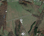
Valley Point (WV29) is a privately owned airport nestled in the hills of Albright, West Virginia. This has been updated from defualt FSX to include the north south grass runway.
Based on local a local flight instructor, the airport should always be approached for landing going north bound towards rising terrain (if the winds are less than 10 knots). This assists with braking. A go around should never be attempted going northbound after the wheels impact the ground.
Takeoffs should always be performed going south bound (if the winds are less than 10 knots) due to steeply rising terrain (300 feet above the airport) to the north.
| Filename: | WV29__Valley_Point_Airport.zip |
| License: | Freeware |
| Added: | 28th June 2021, 04:14:34 |
| Downloads: | 116 |
| Author: | David Abreu |
| Size: | 2.17 KB |


© 2001-2026 AVSIM Online
All Rights Reserved
Privacy Policy |