
Where Flight Simulation Enthusiasts Gather from Around the World!
AVSIM Library - Search Results

| Category: Flight Simulator X - Scenery | |
| MTCH 2011 |

|
File Description:
Cap-Haitien International Airport (IATA: CAP, ICAO: MTCH) is an airport serving Cap-Haitien, a city in the Nord department in Haiti. It is the second largest airport in Haiti.
This file has the right coordenates, with the apron and characteristics of the airport. The runways were resized the gates placed on correct location and number.
| Filename: | MTCH_2011.zip |
| License: | Freeware |
| Added: | 19th August 2011, 00:30:14 |
| Downloads: | 974 |
| Author: | Anwar Gonzalez |
| Size: | 3.32 KB |
| Category: Flight Simulator X - Scenery | |
| New Islamabad International - OPIS |
|
Images related to this file:
File Description:
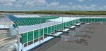
New Islamabad International Airport (ICAO: OPIS) is an airport situated 20KM West of the Capital of Pakistan, Islamabad. It is bound to replace the existing Benazir Bhutto International Airport. The scenery includes Accurate airport layout, Custom made 3D terminal building and the cargo terminal, Correctly placed Taxi signs, Correct Taxiway designators according to charts, and much more.
| Filename: | New_Islamabad_International__OPIS.zip |
| License: | Freeware, limited distribution |
| Added: | 27th June 2017, 00:15:51 |
| Downloads: | 5,130 |
| Author: | Irfan Kaleem |
| Size: | 28.56 MB |
| Category: Flight Simulator X - AFCAD Files | |
| DABB - Rabah Bitat Airport - Annaba, Algeria |
|
Images related to this file:
File Description:
Rabah Bitat Airport (IATA: AAE, ICAO: DABB), formerly known as Les Salines Airport, and popularly as El Mellah Airport is an international airport located 9 km south of Annaba, a city in Algeria. It is named after Rabah Bitat, a president of Algeria (1978-1979). A new terminal is currently under construction which will help increase passenger capacity and replace the outdated current main terminal building. The airport is served by Air Algerie, Aigle Azur and Tassili Airlines.
Features:
*Expanded parking apron
*Taxiways properly designated and aligned
*Runway markings and lighting corrected
*Parking spots for commercial traffic
*Separate parking area for GA traffic
*Misc airport buildings added
*Construction of new terminal with cranes and construction vehicle and objects
*Airport vehicles and objects throughout the airport
*Fuel service vehicles
*Static aircraft
| Filename: | DABB__Rabah_Bitat_Airport__Annaba_Algeria.zip |
| License: | Freeware |
| Added: | 7th February 2014, 06:15:01 |
| Downloads: | 593 |
| Author: | Jaison Diaz / Endeavour ai |
| Size: | 71.41 KB |
| Category: Flight Simulator X - AFCAD Files | |
| ORSU - Sulaimaniyah Intl Airport - Sulaimaniyah, Iraq |
|
Images related to this file:
File Description:
ORSU - Sulaimaniyah International Airport, Kurdistan, Iraq
Sulaimaniyah International Airport is an airport 15 kilometers outside of the city of Sulaimaniyah, in the Kurdistan region of Iraq. The airport has facilities for both cargo and passengers. Sulaimaniyah International Airport has three terminals for departures, arrivals and VIP. The construction of the airport began in November 2003, and it was inaugurated in July 2005 and is unknown to FSX.
Airlines like AtlasJet, Germania, Iraqi airways and FlyDubai visit it regularly.
Using ADEx 1.51 and the IRAQ AIP this airport was built from scratch. Google Earth�´s images are too old (2004) to offer any help regarding buildings, vegetation and surrounding areas like offices, parkings and roads. With the help of pictures found on the real airport site, this is the best rendition for now.
| Filename: | ORSU__Sulaimaniyah_Intl_Airport__Sulaimaniyah_Iraq.zip |
| License: | Freeware |
| Added: | 10th August 2012, 16:53:12 |
| Downloads: | 887 |
| Author: | Menno C. Robert |
| Size: | 3.25 MB |
| Category: Flight Simulator X - AFCAD Files | |
| MGGT - La Aurora International Airport - Guatemala City, Guatemala |
|
Images related to this file:
File Description:

La Aurora International Airport (IATA: GUA, ICAO: MGGT) is the main airport in Guatemala City, Guatemala and the busiest airport in the country. The airport underwent a major expansion and renovation of its main terminal back in 2008 and is currently the fourth busiest airport in Central America by passenger traffic.
Features:
*Runway properly renumbered
*Taxiways properly designed and signs updated
*Expanded parking apron
*Redesigned terminal building to match 2008 renovations/expansion
*Accurate gate assignments
*Runway markings and lighting corrected
*Parking spots for commercial traffic
*Separate parking area for GA traffic
*Misc airport buildings added
*Airport vehicles and objects throughout the airport
*Fuel service vehicles
*Static vehicles (requires objlib-large-car-parking-fsx.zip)
*Light poles (requires fsx_lts.zip)
| Filename: | MGGT__La_Aurora_International_Airport__Guatemala_C.zip |
| License: | Freeware |
| Added: | 14th April 2014, 23:32:28 |
| Downloads: | 1,480 |
| Author: | Jaison Diaz / Endeavour ai |
| Size: | 201.52 KB |
| Category: Flight Simulator 2004 - Scenery | |
| Phoenix Deer Valley Airport |
|
File Description:
FS2004 Scenery-Phoenix Deer Valley Municipal Airport (KDVT) serves Phoenix and Maricopa County and is owned by the City Of Phoenix. The airport has more than one runway. The longest is a paved runway extending 8200 feet. The facility is at an elevation of 1476 feet at a distance of about 15 miles from Phoenix. Phoenix Deer Valley Airport is a general aviation reliever airport for Phoenix Sky Harbor International Airport. The airport is home to more than 1,350 based aircraft and had more than 340,000 takeoffs and landings in 2004. A vital component of the City of Phoenix airport system, Deer Valley is the second busiest general aviation airport in the nation. Scenery created with FSDS2, Rwy12, Lago's FSE, with AFCAD2 and Traffic Tools. Contains 438 parking spaces.
| Filename: | Phoenix_Deer_Valley_Airport.zip |
| License: | Freeware |
| Added: | 23rd September 2005, 20:33:47 |
| Downloads: | 2,011 |
| Author: | John B. Loney, Jr. |
| Size: | 1.46 MB |
| Category: Flight Simulator X - Scenery | |
| FYWH - Hosea Kutako International Airport - Windhoek, Nambia |
|
File Description:
Hosea Kutako International Airport (IATA: WDH, ICAO: FYWH) is the main international airport serving the Namibian capital city of Windhoek. Located 45 km (28 mi) east of the city, it is Namibia's primary airport with international
connections and handled 672,582 passengers in 2007. In 2009, the airport handled around 680,000 passengers, just over 4% down on the previous year when over 710,000 passengers were processed. The airport is named after Namibian hero
Hosea Kutako.
Windhoek Hosea Kutako International Airport underwent a modernizing makeover in 2009. It has one terminal with one departure and one arrival hall.
Airport two runways were corrected also the aprons and buildinds. Airport charts thanks to fly uk virtual airways, www.flyuk.aero/en/index.php?page=airport_opsinfo&id=FYWH.
This work is dedicated to West Wind Airlines.
| Filename: | FYWH__Hosea_Kutako_International_Airport__Windhoek.zip |
| License: | Freeware |
| Added: | 18th June 2013, 04:58:07 |
| Downloads: | 4,277 |
| Author: | Anwar Gonzalez |
| Size: | 586.07 KB |
| Category: Flight Simulator X - AFCAD Files | |
| ZSHC - Hangzhou Xiaoshan Intl - Hangzhou, China |
|
Images related to this file:
File Description:
Hangzhou Xiaoshan International Airport is the principal airport serving Hangzhou, a major city in the Yangtze River Delta region and the capital of Zhejiang Province, China. The airport is located on the southern shore of Qiantang River in Xiaoshan District and is 27 km east of downtown Hangzhou. Hangzhou is a focus city for Air China, China Southern Airlines and Xiamen Airlines. In 2010, Hangzhou airport handled 17,068,585 passengers and became the 9th busiest airport in China. In addition, the airport was the country's 8th busiest airport in terms of cargo traffic and the 10th busiest airport by traffic movements. From Europe, KLM makes direct flights. Using ADEx 1.55, aeronautical maps and Google Earth the default AFCAD has been updated to reflect today's situation. Please read the Readme file for proper installation.
| Filename: | ZSHC__Hangzhou_Xiaoshan_Intl__Hangzhou_China.zip |
| License: | Freeware |
| Added: | 2nd May 2013, 13:52:13 |
| Downloads: | 1,087 |
| Author: | Menno C. Robert |
| Size: | 722.68 KB |
| Category: Flight Simulator X - AFCAD Files | |
| CYWG - Winnipeg James Armstrong Richardson International Airport / Winnipeg, Manitoba, Canada |
|
Images related to this file:
File Description:
CYWG - Winnipeg James Armstrong Richardson International Airport / Winnipeg, Manitoba, Canada
This airport update was made with the latest version of ADE (Airport Design Editor) and made for FSX as a replacement for the stock (default) airport. I found that most stock airports in FSX lack a decent amount of character and realism and this area in particular was dreadful! The stock airport was rather inaccurate. I've made several additions to the airport which are listed below. All these enchancements are as close to the real airport as I can get with stock library objects. I've used satellite images, terminal photos and maps throughout the whole process so building locations are as accurate as possible. Happy landings in the beautiful Canada!
Features:
*Greatly expanded parking apron
*Brand new main terminal building with its 11 jetways and regional airline parking and parking garage
*Old terminal (soon to be demolished) with construction vehicles
*Hangar and other airport buildings added
*Cargo terminal with parking
*Military cargo area
*Airport vehicles and objects throughout the airport
*Main road in front of airport added with static vehicles
*Airport fire station with fire trucks
*Static de-icing area with vehicles
*Old runway 7/25 which was demolished in the 1990s and FSX inexplicably included has been removed
| Filename: | CYWG__Winnipeg_James_Armstrong_Richardson_Internat.zip |
| License: | Freeware |
| Added: | 24th July 2012, 08:12:46 |
| Downloads: | 2,957 |
| Author: | Jaison Diaz |
| Size: | 163.14 KB |
| Category: Flight Simulator 2004 - Scenery | |
| Kish Island 2004 |
|
File Description:
Kish Island 2004 (OIBK)/
Finally after 7 months of developing and in the following of producing succssecfull sceneries for Iran and after one of the most succssecfull sceneries, "Tehran Scenery 2003", Kish Island 2004 is ready. It is new add-on scenery for Microsoft Flight Simulator 2004 with many new features Include: Complete scenery of the Kish Island, Kish Island Landclass, Waterclass, Very detailed objects, Frequency controlled animation, distance controlled animation, Dynamic scenery, Static Scenery, New and more realistic AFCAD, New roads and night lighting, Corrected navigational data, corrected runways data, Corrected apron and runways lighting system, All in Gmax for better performance, Apron Marshaller, certain number of objects in different scenery complexity setting and ….The scenery replaces the Default scenery of Kish Island which is really terrible. This add-on was developed according to the satellite images of the island provided by the "Kish Free Zone" company and contains 3 packages, the complete scenery of Kish Island, New and More realistic Landclass and Waterclass of the island and New Afcad file which is provided according to jeppesen airport chart. By Touradg Morassaei (www.touradg.tk)
| Filename: | Kish_Island_2004.zip |
| License: | Freeware |
| Added: | 15th December 2003, 05:42:57 |
| Downloads: | 10,066 |
| Author: | Touradg Morassaei |
| Size: | 5.34 MB |
© 2001-2026 AVSIM Online
All Rights Reserved
Privacy Policy |