
Where Flight Simulation Enthusiasts Gather from Around the World!
AVSIM Library - Search Results

| Category: Navigation and ATC - Navigation | |
| LSZS - Samedan visual approach chart v3 |

|
Images related to this file:
File Description:
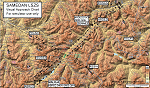
Custom made visual approach chart and pilot's briefing for Engadin (St. Moritz) Samedan LSZS airport in Switzerland, Europe's highest elevation airport (5,600 ft.) situated in the Swiss Alps. This airport is a day VFR operations only and has no instrument approach due to extreme terrain around it. A demanding visual descent into a canyon, in between steep rising terrain, is required to make the visual approaches for both runways with a steep 4.4* degrees final approach portion guided by the PAPI's. Still, executive jets up to Boeing 737(BBJ) size approach the airport often in the winter peak season VFR with these procedures. It is designed as per real operators' pilot briefing for Samedan. Real airport's full pilot briefing document also included. The real airport's excellent briefing (included) intentionally does not contain the maneuvers needed for the approach of jets through the mountains but only reporting points for all and maneuvers for light aircraft only. This gap is what this chart covers. Version 2 chart included better graphics and refined visual procedure for jets and version 3 now includes real pilot's briefing guide.
| Filename: | LSZS__Samedan_visual_approach_chart_v3.zip |
| License: | Freeware, limited distribution |
| Added: | 20th March 2015, 23:35:11 |
| Downloads: | 2,026 |
| Author: | Kyprianos Biris |
| Size: | 7.1 MB |
| Category: Flight Simulator 2002 - Miscellaneous Files | |
| Los Angeles Terminal Area Chart |
|
File Description:
The rendition of Los Angeles´ KLAX airport is one of the most detailed in FS2002 and a great starting point to explore the West Coast. The library hosts a few awesome landclass and mesh files for this area that offer an "as real as it gets" VFR experience if used with this chart. The 1:250.000 scaled chart is scanned in high resolution (8400*4700 pixel). It covers a much smaller area, but offers considerably more detail than the LA sectional. You may use this chart "as is" without any other software, but it will develop its full potential if used as moving map with SimSystem´s FSFlightMax or FSGarmin. It wouldn´t have been possible to offer this chart without Richard Harvey and his love to flightsimming, so please consider this file to be "donationware" and make a however small contribution to the Richard Harvey Endowed Scholarship.
| Filename: | Los_Angeles_Terminal_Area_Chart.zip |
| License: | Check within download |
| Added: | 30th March 2003, 15:27:19 |
| Downloads: | 1,472 |
| Author: | Uwe Rademacher |
| Size: | 28.03 MB |
| Category: Flight Simulator X - AFCAD Files | |
| UWKD - Kazan International Airport - Kazan, Russia |
|
File Description:
Kazan Airport, UWKD, is Russia's seventh busiest airport. I have reworked the FSX stock airport using ADE.
The current airport is vastly different from the FSX stock airport so there are significant changes. Only one runway, the grass runway has gone and the other is now the main taxiway. Revamped aircraft parking and an ILS on both ends of the runway. The Jeppesen Chart and Google Earth were used for data and measurements.
| Filename: | UWKD__Kazan_International_Airport__Kazan_Russia.zip |
| License: | Freeware |
| Added: | 2nd August 2016, 17:12:51 |
| Downloads: | 1,291 |
| Author: | Mike Major |
| Size: | 3.99 MB |
| Category: Flight Simulator 2004 - Miscellaneous Files | |
| In-Flight Entertainment System v0.1 |
|
File Description:
It's a set of web pages which replace the key-commands section of your in-flight kneeboard. It includes an MP3 player, newsfeeds, an image viewer, web and email access, and some games. More to come in the next version...
| Filename: | InFlight_Entertainment_System_v01.zip |
| License: | Freeware |
| Added: | 10th August 2005, 17:51:37 |
| Downloads: | 1,983 |
| Author: | Matt Caine |
| Size: | 2.25 MB |
| Category: Flight Simulator X - Scenery | |
| Wejh Airport OEWJ Saudi Arabai |
|
File Description:
Wejh Airport OEWJ NW of Saudi Arabia scenery project adds Terminal
and buildings , 2 apron parking medium category aircrafts
numbered in the correct order ,as latest chart
stock FSX scenery objects were added to resemble as closely as possible,
The airport updated to reflect current satellite imagery and positioning ,
it should work for p3d
| Filename: | Wejh_Airport_OEWJ_Saudi_Arabai.zip |
| License: | Freeware |
| Added: | 16th December 2018, 17:52:21 |
| Downloads: | 329 |
| Author: | Mohamed Salamoni |
| Size: | 7.37 MB |
| Category: Flight Simulator 2004 - Flight Plans | |
| Level D 767 VHHH (Hong Kong) Navdata |
|
File Description:
This is the Navdata for Hong Kong International Airport (VHHH) for LDS 767. It is based on all real charts and should be accurate. Require LDS 767 to make this work. Have fun. Also, thanks Dragon Virtual (www.vdhk.org) to providing chart informations.
| Filename: | Level_D_767_VHHH_Hong_Kong_Navdata.zip |
| License: | Freeware, limited distribution |
| Added: | 30th March 2005, 22:37:33 |
| Downloads: | 1,250 |
| Author: | Ken Kwan |
| Size: | 3.47 KB |
| Category: Flight Simulator 2004 - AFCAD Files | |
| Project LKPR X - ver 080605 Scenery |
|
Images related to this file:
File Description:

AFCAD2 for Project LKPR X - ver 080605 Scenery, by Pavel Benes, Filip Dvorak, Karel Kriz
Reworked using, in the order:
1 - Airport related chart
2 - Scenery parking spaces available on the scenery itself and not covered by signed a/c parking.
http://www.genixsoft.com
| Filename: | Project_LKPR_X__ver_080605_Scenery.zip |
| License: | Freeware |
| Added: | 6th February 2011, 01:56:12 |
| Downloads: | 407 |
| Author: | Vincenzo Mercolino |
| Size: | 39.12 KB |
| Category: Fly! II - Navigation | |
| 16 Navaids DK |
|
File Description:
16 Add-on navigation (NAVs) from Aeronautical chart- ICAO 1:500,000
| Filename: | 16_Navaids_DK.zip |
| License: | Freeware |
| Added: | 1st June 2003, 13:25:51 |
| Downloads: | 410 |
| Author: | Skovbjerg Lars |
| Size: | 1.56 KB |
| Category: Flight Simulator 2004 - AFCAD Files | |
| ZMBH Bayankhongor Mongolia |
|
File Description:
Afcad for Bayankhongor, made using Jeppesen aerodrome chart and Google earth.
| Filename: | ZMBH_Bayankhongor_Mongolia.zip |
| License: | Freeware |
| Added: | 9th December 2013, 18:55:58 |
| Downloads: | 183 |
| Author: | Nick Langley |
| Size: | 1.82 KB |
| Category: Flight Simulator X - Utilities | |
| FS-Butler v1.1.10 |
|
File Description:
The paperless cockpit - features of FS-Butler: Management of maps, information, files, etc. The documents are sorted into the following categories: General, Airport, and Aircraft. A viewer is integrated for the *.Bmp and *.Jpg. You may input NAV/COM/ADF/SQUAWK/COURSE values quickly via the keyboard to type and send it to FSX via FSUIPC (freeware version). New: FS-Butler allows toggle between German and English. Automatic updates of the program included.
| Filename: | FSButler_v1110.zip |
| License: | Freeware |
| Added: | 18th April 2012, 19:18:46 |
| Downloads: | 637 |
| Author: | Juergen Beisler |
| Size: | 5.04 MB |
© 2001-2026 AVSIM Online
All Rights Reserved
Privacy Policy |