
Where Flight Simulation Enthusiasts Gather from Around the World!
AVSIM Library - Search Results

| Category: Flight Simulator 2004 - Original Aircraft | |
| Wideroe De Havilland Canada DHC-8-400 Dash 8 (Dreamwings) |

|
File Description:
Dreamwings is proud to finally present the DHC Dash 8 Q-400! This aircraft model includes most of the standard features including: animated control surfaces (flaps, spoliers, ailerons...etc), wingviews, highly detailed 32-bits textures, "see-through" cabin, animated doors (passenger and cargo), animated airstair, reflective textures and dynamic shine. Please read the included Readme for more information and for full support, visit our forum at http://www.dreamwingsdesign.com/forum. This aircraft is painted in the Wideroe´s livery
| Filename: | Wideroe_De_Havilland_Canada_DHC8400_Dash_8_Dreamwi.zip |
| License: | Freeware, limited distribution |
| Added: | 17th October 2004, 22:07:49 |
| Downloads: | 9,755 |
| Author: | Dreamwings, Tommy Hansson |
| Size: | 5.25 MB |
| Category: Flight Simulator X - Aircraft Repaints, Textures and Modifications | |
| RNoAF, de Havilland Canada DHC-6-100 Twin Otter, v1 |
|
Images related to this file:
File Description:
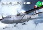
Aerosoft DHC-6-100 Twin Otter in the colours of the Royal Norwegian Air Force, two versions: wheels and ski equiped
| Filename: | RNoAF_de_Havilland_Canada_DHC6100_Twin_Otter_v1.zip |
| License: | Freeware |
| Added: | 22nd December 2011, 13:52:13 |
| Downloads: | 373 |
| Author: | Tom Weiss |
| Size: | 8.62 MB |
| Category: Flight Simulator 2004 - Scenery | |
| Glacier Bay - Alaska/Canada, Version 2, Part 1 of 2 |
|
Images related to this file:
File Description:
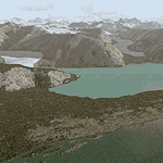
Glacier Bay v2 is a complete replacement of the default FS2004 landscape and scenery of more than 90,000 square kilometers (36,000 sq miles) of Southeast Alaska and adjacent areas of Yukon and British Columbia. File 1 of 2 (also requires glbayv2b.zip)
Landscape enhancements include high-resolution terrain mesh, detailed shorelines, rivers, lakes, and glaciers, and accurate land cover data with custom seasonal ground textures. Inland water bodies can be made to "freeze over" via an on/off switch. Other landmarks include the settlements of Juneau, Haines, Skagway, Yakutat, Atlin, and Carcross as well as road and railroad networks, cabins, lodges, and lighthouses. We modeled or enhanced 16 main airfields (plus one fictitious airstrip), 20 unlisted airstrips, 16 seaplane bases, and seven heliports. We've also included AI ship traffic in various locations as well as optional flightplans for GA and floatplane AI traffic.
Glacier Bay v2 is fully compatible with other third-party add-ons, including terrain mesh (FSGlobal, FS Genesis, etc.), ground textures (Ground Environment, BEV, FScene, etc.), and landscape enhancements (Ultimate Terrain Canada/Alaska, Misty Fjords, Tongass Fjords, Freight Dogs). A configurator panel (requires .Net Framework!) allows users to set compatibility options and to choose levels of scenery detail. We provide an autoinstaller and detailed documentation with a sectional map of the coverage area and a list of weblinks to real-world information.
For feedback and questions, please visit the Glacier Bay v2 support forum at http://forums.fsaddon.eu/viewforum.php?f=10. This project is a collaboration of nine FS developers from Germany, Austria, USA, and Canada, logging more than 1000 hours of work over the past 14 months. We acknowledge the kind support of FSAddon.com. However, this project is independent of any commercial company or product. Enjoy!
| Filename: | Glacier_Bay__AlaskaCanada_Version_2_Part_1_of_2.zip |
| License: | Freeware, limited distribution |
| Added: | 28th May 2010, 19:34:54 |
| Downloads: | 41,280 |
| Author: | Holger Sandmann, Rainer Duda, Michael Eder, Scot Fraser, Manfred Herz, Jay Langham, Jon Patch, Larry Silsbee, and Jim Vile |
| Size: | 56.46 MB |
| Category: Flight Simulator 2002 - Original Aircraft | |
| Qantas Link De Havilland Canada DHC-8-300 Dash 8 |
|
File Description:
FS2002 PRO - Qantas Link Dash-8 300 VH-TQY Ver 6 with full moving parts, Night effects and animated textures.
| Filename: | Qantas_Link_De_Havilland_Canada_DHC8300_Dash_8.zip |
| License: | Freeware |
| Added: | 24th June 2002, 04:24:16 |
| Downloads: | 2,103 |
| Author: | Aircraft design by Barry Blaisdell, Repainted by Stephen Newton |
| Size: | 384.15 KB |
| Category: Flight Simulator 2004 - AI Aircraft | |
| LADE-Lineas Aereas del Estado De Havilland Canada DHC-6 |
|
Images related to this file:
File Description:
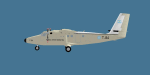
Repaint of the Henry Tomkiewicz/Project AI Twin Otter in LADE-Lineas Aereas del Estado colours. Includes files for both HTAI and Project AI versions and comes with a FSX prop texture, FS9 prop texture is included too.
| Filename: | LADELineas_Aereas_del_Estado_De_Havilland_Canada_D.zip |
| License: | Freeware |
| Added: | 14th October 2013, 20:28:59 |
| Downloads: | 392 |
| Author: | Chris Peschke,PAI |
| Size: | 269.9 KB |
| Category: Flight Simulator 2004 - Scenery | |
| Glacier Bay - Alaska/Canada, Version 2, Part 2 of 2 |
|
Images related to this file:
File Description:

Glacier Bay v2 is a complete replacement of the default FS2004 landscape and scenery of more than 90,000 square kilometers (36,000 sq miles) of Southeast Alaska and adjacent areas of Yukon and British Columbia. File 2 of 2 (also requires glbayv2a.zip)
Landscape enhancements include high-resolution terrain mesh, detailed shorelines, rivers, lakes, and glaciers, and accurate land cover data with custom seasonal ground textures. Inland water bodies can be made to "freeze over" via an on/off switch. Other landmarks include the settlements of Juneau, Haines, Skagway, Yakutat, Atlin, and Carcross as well as road and railroad networks, cabins, lodges, and lighthouses. We modeled or enhanced 16 main airfields (plus one fictitious airstrip), 20 unlisted airstrips, 16 seaplane bases, and seven heliports. We've also included AI ship traffic in various locations as well as optional flightplans for GA and floatplane AI traffic.
Glacier Bay v2 is fully compatible with other third-party add-ons, including terrain mesh (FSGlobal, FS Genesis, etc.), ground textures (Ground Environment, BEV, FScene, etc.), and landscape enhancements (Ultimate Terrain Canada/Alaska, Misty Fjords, Tongass Fjords, Freight Dogs). A configurator panel (requires .Net Framework!) allows users to set compatibility options and to choose levels of scenery detail. We provide an autoinstaller and detailed documentation with a sectional map of the coverage area and a list of weblinks to real-world information.
For feedback and questions, please visit the Glacier Bay v2 support forum at http://forums.fsaddon.eu/viewforum.php?f=10. This project is a collaboration of nine FS developers from Germany, Austria, USA, and Canada, logging more than 1000 hours of work over the past 14 months. We acknowledge the kind support of FSAddon.com. However, this project is independent of any commercial company or product. Enjoy!
| Filename: | Glacier_Bay__AlaskaCanada_Version_2_Part_2_of_2.zip |
| License: | Freeware, limited distribution |
| Added: | 28th May 2010, 19:36:31 |
| Downloads: | 40,552 |
| Author: | Holger Sandmann, Rainer Duda, Michael Eder, Scot Fraser, Manfred Herz, Jay Langham, Jon Patch, Larry Silsbee, and Jim Vile |
| Size: | 85.99 MB |
| Category: Flight Simulator 2004 - Original Aircraft | |
| Provincial Airlines De Havilland Canada DHC-8-100 Dash 8 |
|
File Description:
FS2004 Dehavilland Dash8-Q102. A twin turboprop regional airliner. Provincial Airlines, Reg_ID: C-GPAL. An all new FSDS2.24 design
with 2D panel, Dynamic VC, and Custom Sound. In addition, a custom TCAS (Traffic Collision Avoidance System), a complete Ground
Handling module with push back and taxi speed control and the latest version GPWS (Ground Proximity Warning System) is included.
The visual model features an opening airstair with detailed cabin interior, operating Cargo Door, lift dump and roll control spoilers,
passenger wing and cabin views, and high definition reflective textures. A comprehensive set of html documents (Check List & Ref List)
are included for in-flight information. A separate Panel_Docs folder with panel and systems help files, pilot's notes and more.
| Filename: | Provincial_Airlines_De_Havilland_Canada_DHC8100_Da.zip |
| License: | Freeware, limited distribution |
| Added: | 23rd May 2005, 04:48:53 |
| Downloads: | 6,161 |
| Author: | Jean-Pierre Brisard, Barry Blaisdell, Bob May - Premier Aircraft Design |
| Size: | 21.32 MB |
| Category: Flight Simulator 2004 - Scenery | |
| Rae Lakes CYRA at Gameti in the Northwest Territories, Canada |
|
Images related to this file:
File Description:
Gameti is a village in the Northwest Territories, around 65 miles north of Whati which was recently posted. Until 2005 the village, which has a population of around 280, was known as Rae Lakes and the airfield is now renamed Gameti/Rae Lakes as shown in the 2010 version of the Nav Canada Flight Supplement, my standard reference year. Permanent settlement was established there in 1965. There is no all-weather road access and the village is reliant upon the airfield for supplies, along with an ice road in the winter months. The airfield is a mile or so east of the village, with a lit gravel runway of just over 3,000 feet aligned 14-32 and with PAPI at both ends. The airfield is served by Air Tindi from Yellowknife on an almost daily basis, included in the AI here along with some GA and a Friday delivery by a Buffalo DC3 that uses all of the runway. The runway has lake water at each end, ready for the unwary. A note here about my scenery making. There will not be many more to follow this as I am almost at the end of the photos I either took or found for scenery purposes, plus I expect to move on from FS9 at some point during next year.
| Filename: | Rae_Lakes_CYRA_at_Gameti_in_the_Northwest_Territor.zip |
| License: | Freeware, limited distribution |
| Added: | 26th December 2019, 19:32:09 |
| Downloads: | 122 |
| Author: | Roger Wensley |
| Size: | 4.81 MB |
| Category: Flight Simulator 2004 - Scenery | |
| Indian Creek Farm Field CF07 near Ottawa in Ontario, Canada |
|
Images related to this file:
File Description:
Indian Creek farm field (Re-upload WITH THE MISSING TEXTURES!) is in Ontario and southeast of Ottawa, less than two miles east of two other real-life farm fields I have already posted (Russell Farm, and Russellette Strip). The creek is just north of the runway in the trees, though it doesn't show in FS with or without Ultimate Terrain.
There is a grass runway 08/26 that is 2,100 feet long and has lights; the grass could be better (I mean there could be more of it) but the drainage is good. There is a large hangar that is right by the house and is heated (wow!); this is for the owner. There are also eight other hangars which are slightly basic and without doors, which means boxes over the wheels so the tires don't get chewed by the wild life and canvas hangar fronts for the winter. All the hangar buildings are modeled specifically for this scenery. The runway has been there for 22 years, and before that (though with a large gap between) there was a military grass strip as a relief field for nearby Pendleton .
| Filename: | Indian_Creek_Farm_Field_CF07_near_Ottawa_in_Ontari.zip |
| License: | Freeware, limited distribution |
| Added: | 8th February 2010, 09:45:16 |
| Downloads: | 442 |
| Author: | Roger Wensley |
| Size: | 11.35 MB |
| Category: Flight Simulator 2004 - Scenery | |
| Mackenzie River close to Tulita CZFN in Northwest Territories Canada |
|
Images related to this file:
File Description:
I discovered, while testing another airfield near the Mackenzie River, that along the side of the Mackenzie adjacent to Tulita, and for a considerable distance, there was a cliff of water. I have no idea if my version of Ultimate Terrain has developed a fault or if this has been caused by the installation of a terrain mesh that now argues with UT for some unknown reason. Whatever, it was impossible to leave it as it was. I have included a screenshot of the cliff further upstream. To avoid the cliff of water I have flattened that area of the Mackenzie River and the adjacent river banks and both the town and the airfield to a height above sea level of 400 feet. This does not reflect the real life situation but is the lesser of two optical evils. I have included a screenshot of the flattened area. If you do not have a problem then you do not need this. If you too have a cliff of water then you might want to try this. It does not completely get rid of the problem, but it does get rid of it in the area visible when landing or taking off at Tulita.
| Filename: | Mackenzie_River_close_to_Tulita_CZFN_in_Northwest_.zip |
| License: | Freeware, limited distribution |
| Added: | 1st August 2021, 22:27:01 |
| Downloads: | 74 |
| Author: | Roger Wensley |
| Size: | 573.48 KB |
© 2001-2026 AVSIM Online
All Rights Reserved
Privacy Policy |