
Where Flight Simulation Enthusiasts Gather from Around the World!
AVSIM Library - Search Results

| Category: Flight Simulator 2004 - Scenery | |
| Montreal Bridges V1.0, Champlain bridge, Montreal, Quebec, Canada. |

|
File Description:
This scenery is the most accurate rendition I could come up with of the CHAMPLAIN BRIDGE and it's ICE BRIDGE, located on the south shore of MONTREAL. It is compatible with FS2004 and FS2002. We plan to add more Montreal bridges in future releases, that's why it is called "Montreal Bridges".
| Filename: | Montreal_Bridges_V10_Champlain_bridge_Montreal_Que.zip |
| License: | Freeware |
| Added: | 26th April 2004, 12:38:07 |
| Downloads: | 9,231 |
| Author: | Guy F. Jutras, Quebec Virtual Pilot. |
| Size: | 1.34 MB |
| Category: Flight Simulator 2004 - Scenery | |
| Waskaganish CYKQ in James Bay, Quebec, Canada - Update |
|
Images related to this file:
File Description:
This update for Waskaganish CYKQ provides the AFCAD that was not included in the original post, and advises on a remedy for a possible village texture problem.
| Filename: | Waskaganish_CYKQ_in_James_Bay_Quebec_Canada__Updat.zip |
| License: | Freeware, limited distribution |
| Added: | 23rd October 2010, 21:40:19 |
| Downloads: | 352 |
| Author: | Roger Wensley |
| Size: | 180.14 KB |
| Category: Flight Simulator 2004 - Scenery | |
| Repost of Dryden Regional CYHD in Ontario Canada |
|
File Description:
This repost is first to deal with some lighting problems on the runways (though I still couldn't get rid of the taxiway lights that head off across the grass) and also to provide the right AFCAD file.
Dryden is in northwest Ontario on the shore of Wabigoon Lake. The airfield is some five miles northeast of the town. It has two runways, one 2,000 feet long and sand, the other 11/29 and 6,000 feet of asphalt 150 feet wide. There is a terminal building, a hangar for Thunder Airlines, and some GA hangars at and near the western apron, and in the Summer there is a flock of fire-fighting Canadair CL415 amphibs at the eastern apron together with the Ministry of Natural Resources Ontario fire fighting headquarters establishment, accomodation, and maintenance facilities. Among others Bearskin Airlines fly there, a wonderful punning name.
| Filename: | Repost_of_Dryden_Regional_CYHD_in_Ontario_Canada.zip |
| License: | Freeware |
| Added: | 15th February 2009, 15:34:49 |
| Downloads: | 597 |
| Author: | Roger Wensley |
| Size: | 4.51 MB |
| Category: Flight Simulator 2004 - Scenery | |
| CYYQ - Churchill Port & York Factory - Northern Manitoba, Canada |
|
Images related to this file:
File Description:
The main part of this scenery installs the Port of Churchill and the grain silos. Churchill CYYQ has been made by Sidney Schwartz, and this also adds AI and slightly modifies his parking to make a space big enough for Buffalo's C46. Churchill is in northern Manitoba, on the Churchill River where it empties into Hudson Bay. The town is accesible by air, by boat (once the winter ice melts) and most importantly by rail from the south. Grain from the Canadian prairies is hauled north and stored in Churchill for export to Europe by a sea route that is significantly shorter than any other, and there is a grain carrier included in the AI. Today there are perhaps 810 people living in Churchill, a slowly declining number. There are also a number of impressive polar bears. There was another port south of Churchill, but it was never completed, never connected to a railroad track, and never used. It was called Port Nelson, and was at the mouth of the Nelson River. Nearby, on the Hayes River, there is an old trading post called York Factory, built in 1684 and preserved as part of the living history of the north of Canada. The second scenery is for this, and for the nearby tourist camp called Silver Goose Lodge, which as the name suggests is for hunters. The large grassy area alongside the fort was for the trappers to camp on when they all arrived in early summer to trade the furs for goods.
| Filename: | CYYQ__Churchill_Port__York_Factory__Northern_Manit.zip |
| License: | Freeware, limited distribution |
| Added: | 23rd July 2014, 02:26:04 |
| Downloads: | 542 |
| Author: | Roger Wensley |
| Size: | 3.69 MB |
| Category: Flight Simulator 2004 - Scenery | |
| Ontario Small Fields in Canada: #01 Leamington (CLM2) |
|
Images related to this file:
File Description:
This is the first of a series of small airfields in southern Ontario, Canada. It is Leamington CLM2, a field near a small town of the same name beside Lake Erie. The airfield has an asphalt runway of 3,820 feet, though with displaced thresholds at each end due to electric cable strung along the roads for an effective landing length of around 2,800. Right-hand circuits for runway 19 to avoid over-flying a nature reserve around a stretch of shallow water to the northeast. The intention is that downloaders will add further posts to the first, which will avoid unnecessary texture duplication (for instance for parked cars or planes) and avoid adding yet another small field to the FS9 scenery library. The second airfield will probably be Harrow CGL2, a grass field to the west of Leamington.
| Filename: | Ontario_Small_Fields_in_Canada_01_Leamington_CLM2.zip |
| License: | Freeware, limited distribution |
| Added: | 18th July 2015, 15:03:26 |
| Downloads: | 162 |
| Author: | Roger Wensley |
| Size: | 3.23 MB |
| Category: Flight Simulator 2004 - Scenery | |
| Ontario Small Fields in Canada: #6 Nixon CNX8 |
|
Images related to this file:
File Description:
This is the sixth in a series of small airfields in southern Ontario Canada, Nixon CNX8, an airfield 20 miles south of Brantford and 10 miles north of Lake Erie, just west of the small town of Simcoe. It was not included in FS9 as it did not exist then; I do not know when it was first registered, but it was prior to April 2010 (the date of the oldest copy of the Canada Flight Supplement that I have with me). The airfield has a grass runway of 2,800 feet aligned 12/30, unlit. The owner has a small crop-spraying business, and there are also hangars rented to local plane owners. Fuel and oil is available.
This scenery post is not necessarily complete in itself and presumes you are adding it to the series of Ontario Small Fields.
| Filename: | Ontario_Small_Fields_in_Canada_6_Nixon_CNX8.zip |
| License: | Freeware, limited distribution |
| Added: | 27th October 2015, 12:11:48 |
| Downloads: | 145 |
| Author: | Roger Wensley |
| Size: | 5.41 MB |
| Category: Flight Simulator X - Aircraft Repaints, Textures and Modifications | |
| De Havilland Canada DHC-2 Beaver (VH-AAO) |
|
Images related to this file:
File Description:
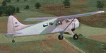
This folder contains a repaint for the Milviz DHC-2 Beaver, representing c/n 146 VH-AAO, which was originally delivered to the Government of Malaya as VR-RBW in 1951, later flying with Malayan Airways, before being imported to Australi in 1960, flying with Aerial Agriculture until 1982. It is still current after a rebuild in 2009, being based at Armidale NSW. Repaint by Jan Kees Blom, based on the paintkit by Milviz.
| Filename: | De_Havilland_Canada_DHC2_Beaver_VHAAO.zip |
| License: | Freeware |
| Added: | 8th August 2018, 10:50:10 |
| Downloads: | 160 |
| Author: | Jan Kees Blom |
| Size: | 10.6 MB |
| Category: Flight Simulator 2004 - Scenery | |
| Peace River CYPE in northwest Alberta, Canada UPDATED |
|
Images related to this file:
File Description:
This is an updated version of the original post (from 2014) made in November 2018. It provides missing textures, and deals properly with an ai problem that I thought I had already fixed. It also adds extra objects to the apron area and adds a third gate. It is complete in itself and can be installed as-is if you do not have the original post. The Peace River flows east from the Rockies, joining up with the Slave River to empty into Great Slave Lake. The town is on both banks close to a bend where the Peace turns to the north, 245 miles northwest of Edmonton. The population is 7,000 and the surrounding area is either farmland or forest. The airport is just over 3 miles west of the town. The runway is 5,000 feet of wide asphalt (150 feet) aligned 04/22, lit, and with PAPI. There is a second runway to the south of the main runway, 1,900 feet of grass and aligned 08/26. The apron is to the north of the runway at the eastern end and is large; there is a purpose-built terminal building, plus other hangar buildings along taxiway C that extends westward from the apron. The airport is experiencing an increase in scheduled and GA flights in the last few years.
| Filename: | Peace_River_CYPE_in_northwest_Alberta_Canada_UPDAT.zip |
| License: | Freeware, limited distribution |
| Added: | 10th December 2018, 17:33:25 |
| Downloads: | 127 |
| Author: | Roger Wensley |
| Size: | 24.27 MB |
| Category: Flight Simulator 2004 - Scenery | |
| Fort Simpson CYFS in the Northwest Territories, Canada |
|
Images related to this file:
File Description:
Fort Simpson is the sixth in a series of airfields that follow (approximately) in a southward direction the Mackenzie River. At the far northern end of the river is Tuktoyaktuk, then Inuvik, Fort McPherson, Fort Good Hope, Deline, Wrigley, and Fort Simpson Island, all posted. Fort Simpson is at 555 feet asl and on the west bank of the the Liard River, close to Fort Simpson Island and where the Liard and the Mackenzie join up. The town of Fort Simpson is on an island, and has a population of 1,250 or so folks. The Hudson Bay trading post was established here in 1822. The new(er) Fort Simpson airport is just over seven miles south of the town, and has 6,000 feet of asphalt runway. It may be from the WW2 time, as it seems there was originally a second runway which has now totally disappeared, There are scheduled flights by First Air and Air Tindi, plus I have added a Buffalo DC3 and GA. There is a mandatory radio frequency which is for both CYFS and CET4 and in this case I have set the "tower" to "manned" so you will report position and obey instructions. There is fuel available. I have added the ferry at the crossing of the Liard River just south of the field.
| Filename: | Fort_Simpson_CYFS_in_the_Northwest_Territories_Can.zip |
| License: | Freeware, limited distribution |
| Added: | 7th July 2014, 22:46:00 |
| Downloads: | 307 |
| Author: | Roger Wensley |
| Size: | 14.18 MB |
| Category: Flight Simulator 2004 - Scenery | |
| Clyde River CYCY & Cape Christian in Nunavut Canada |
|
Images related to this file:
File Description:
Clyde River is a village on the northeast coast of Baffin Island, 250 miles above the Arctic Circle and around 150 miles north of Cape Hooper. It is on the shore of Patricia Bay at the entrance to Cylde Inlet, a fjord which stretches over 60 miles inland. The population is around 880 folks, and it was named by the explorer John Ross in 1818. The airfield is just east of the village and the lighted runway is 3,501' of 100' wide gravel at 87' ASL, aligned 018 True 198 True; "True" as opposed to magnetic in the Northern Domestic Airspace. There are two aprons, one with the new terminal building and one with the old terminal and the garage. Five miles northeast of Clyde River is Cape Christian, where there is a gravel runway around 3,000' long and adjacent to the beach, built to serve what was started as a weather station and later became a LORAN navigation system station. The station is still there, though it was closed some time ago and is now the subject of decontamination work. The runway is usable, though only for light planes as it is a bit rough. First Air and Canadian North are the AI planes visting Clyde River.
| Filename: | Clyde_River_CYCY__Cape_Christian_in_Nunavut_Canada.zip |
| License: | Freeware |
| Added: | 14th July 2011, 20:26:14 |
| Downloads: | 454 |
| Author: | Roger Wensley |
| Size: | 3.33 MB |
© 2001-2026 AVSIM Online
All Rights Reserved
Privacy Policy |