
Where Flight Simulation Enthusiasts Gather from Around the World!
AVSIM Library - Search Results

| Category: Flight Simulator 2004 - Scenery | |
| Fort Smith CYSM in Northwest Territories, Canada Revised |

|
Images related to this file:
File Description:
This is an updated version to remove an incomplete static Beaver reported by Graeme (thanks Cobber) and to include other modifications that I made for my own version since posting the original; different taxiway lights, revised aprons, and in particular the revised AI that I mentioned in the original 2011 post. This is complete and can be installed as-is, or used to modify an existing post by changing the original folder contents. Fort Smith is just north of the border between Alberta and Northwestern Territories, midway between Lake Athabasca to the southeast and Great Slave Lake to the north west. You might stop there when flying between Yellowknife or Hay River to La Ronge or Saskatoon. It looks as if it is ex-military and these are the remains of what were once 10,000 feet of asphalt runways. The main runway is now 11/29 and 6,000 feet long, and the secondary one is 1,800 feet of mostly gravel. There is an airline based at the field, Northwestern Air, and fuel is available at a self service point. The town of Fort Smith is two miles east of the airfield, on the bank of the Slave River and where there are some rapids that require a portage to get around them. Before aviation came along the river was a major route to the north and all those furry animals, which was why the Hudson's Bay Company established an outpost there in 1872. Today it has a population of 2,400 and the main activities are government administration of much of the Northwest Territories, education, and tourism.
| Filename: | Fort_Smith_CYSM_in_Northwest_Territories_Canada_Re.zip |
| License: | Freeware, limited distribution |
| Added: | 23rd January 2019, 19:14:44 |
| Downloads: | 143 |
| Author: | Roger Wensley |
| Size: | 7.16 MB |
| Category: Flight Simulator 2004 - Scenery | |
| Fort Liard CYJF in the Northwest Territories, Canada |
|
Images related to this file:
File Description:
Fort Liard is the seventh in a series of airfields that follow (approximately) the Mackenzie River. At the far northern end of the river there is Tuktoyaktuk, then Inuvik, Fort McPherson, Fort Good Hope, Deline, Wrigley, and then Fort Simpson Island and Fort Simpson, all posted. Fort Liard is at 708 feet asl and on the east bank of the the Liard River, around 130 miles south of Fort Simpson where the Liard and Mackenzie join, and about 25 miles from the borders with both British Columbia and the Yukon. The town has a population of about 560 folks.
The airport is next to the town, and has almost 3,000 feet of gravel runway. I have no information regarding when it was built but it may be from the WW2 time; the cleared and grassed area is long enough for a runway 0f 6,000 feet. There are no scheduled flights but North Cariboo Air have a base at the airport for local charters to support survey teams etc. and are almost an on-demand-scheduled airline. I have also added a Buffalo DC3 and GA. There is fuel available, but only by prior arrangement with North Cariboo. Right hand circuits for runway 20.
| Filename: | Fort_Liard_CYJF_in_the_Northwest_Territories_Canad.zip |
| License: | Freeware, limited distribution |
| Added: | 11th July 2014, 13:38:49 |
| Downloads: | 301 |
| Author: | Roger Wensley |
| Size: | 10.07 MB |
| Category: Flight Simulator 2004 - Scenery | |
| Smiths Falls CYSH near Ottawa in Ontario Canada |
|
Images related to this file:
File Description:
Smiths Falls airfield is four miles east of the town of Smiths Falls and some 30 miles southwest of Ottawa. In bad visiblity it can be found by following the multiple power lines that run east-west half a mile or a mile north of the airfield. There are 45 hangars on the airfield and I have run out of time for modelling the last ten; I will get to them, but later. All of the hangars in the front line visible from the runway have been newly modeled specifically for this, along with the radio shed, gas pump shed, odds-and-ends shed, flying club office, and the new clubhouse, making 40 buildings in all. The old clubhouse burnt down in the summer of 2006, and the concrete slab is still there beside the car park. The new building cannot be anything other than an improvement.
| Filename: | Smiths_Falls_CYSH_near_Ottawa_in_Ontario_Canada.zip |
| License: | Freeware, limited distribution |
| Added: | 14th February 2010, 14:40:44 |
| Downloads: | 430 |
| Author: | Roger Wensley |
| Size: | 5.14 MB |
| Category: Flight Simulator X - Scenery | |
| Laviolette bridge, Trois-Rivières, Québec Canada for FSX |
|
File Description:
The Laviolette bridge (in French, pont Laviolette) connecting the city of Trois-Rivières and Bécancour on the South shore of the Saint Lawrence River (Highway 55) is an important land mark for pilots flying between Montreal (CYUL) and Quebec City (CYQB). It is a beautiful and aesthetic arch bridge of 2.7km long with a main span of 335m and a total height of 106,6m
A lot of attention to details was required to reproduce the bridge complex structure. This scenery features a very accurate bridge with 4 lanes traffic, night textures, road lighting and static ships. Pilots are invited the take off from nearby CYRQ airport at the control of their favourite helicopter or slow aircraft to fly around the bridge to inspect the structure and appreciate the view.
| Filename: | Laviolette_bridge_TroisRivires_Qubec_Canada_for_FS.zip |
| License: | Freeware |
| Added: | 14th March 2008, 09:22:13 |
| Downloads: | 8,093 |
| Author: | Gilles Boily |
| Size: | 1.36 MB |
| Category: Flight Simulator 2004 - AI Aircraft | |
| Winair de Havilland Canada DHC-6 (PJ-WII) |
|
Images related to this file:
File Description:
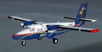
Textures only for the Winair DHC6 - PJ-WII '50th Anniversary' PAI/HTAI (Henry Tomkiewicz) base model required. DHC6.bmp & Prop-hs.bmp 32bit textures. Modified prop texture and thumbnail included. Supports FS9, FSX also P3D V2.5
| Filename: | Winair_de_Havilland_Canada_DHC6_PJWII.zip |
| License: | Freeware |
| Added: | 20th March 2015, 01:51:22 |
| Downloads: | 831 |
| Author: | Finbar Lesmond |
| Size: | 718.42 KB |
| Category: Flight Simulator 2002 - Scenery | |
| Monashee-Selkirk Region of Southern B.C., Canada Mesh |
|
File Description:
New high-resolution (76-m) terrain mesh of two mountain ranges in south-central British Columbia, covering a 1.5-degree longitude by 2.5-degree latitude transect (N48.5-51, W117-118.5) from south of the U.S. border to Revelstoke and Glacier National Park. Visit the steep valleys and high alpine areas enclosed by Slocan Lake and the Arrow Lakes. Made from 50-m digital elevation data, resampled to LOD9 (76-m) horizontal spacing. Designed as an add-on to my LOD7 mesh of the entire province but can be used independently.
| Filename: | MonasheeSelkirk_Region_of_Southern_BC_Canada_Mesh.zip |
| License: | Freeware, limited distribution |
| Added: | 19th January 2003, 23:59:34 |
| Downloads: | 3,683 |
| Author: | Holger Sandmann |
| Size: | 4.98 MB |
| Category: Flight Simulator 2002 - Scenery | |
| Lower Mainland of Southern British Columbia, Canada Mesh |
|
File Description:
New high-resolution (76-m) terrain mesh of the Lower Mainland area of British Columbia, covering a 4-degree longitude by 1.5-degree latitude transect (N48.5-50, W120-124) from Bowen Island to Manning Park. It gives a much better representation of the subtle terrain in Vancouver and the Fraser Valley, the beautiful North Shore Mountains, and the extreme topography of the North Cascades southeast of Chilliwack. Made from 100-m digital elevation data, resampled to LOD9 (76-m) horizontal spacing. Designed as an add-on to my LOD7 mesh of the entire province but can be used independently. By Holger Sandmann.
| Filename: | Lower_Mainland_of_Southern_British_Columbia_Canada.zip |
| License: | Freeware, limited distribution |
| Added: | 20th January 2003, 18:17:35 |
| Downloads: | 6,160 |
| Author: | Holger Sandmann |
| Size: | 8.29 MB |
| Category: Flight Simulator 2004 - Aircraft Repaints, Textures and Modifications | |
| Qantas Link De Havilland Canada DHC-8-400 |
|
File Description:
The Dreamwings Dash 8-Q400 in the livery of Qantas Link 32 bits no mip map. FICTIONAL LIVERY, The tail number is also FICTIONAL. Virtual aircraft for FS2004 FS2002. Virtual aircraft for FS2004 FS2002. JEFFNC - http://www.ncpaint.freezee.org - Original aircraft - http://www.dreamwingsdesign.com. Thanks to Dreamwings for producing this excellent aircraft.
| Filename: | Qantas_Link_De_Havilland_Canada_DHC8400.zip |
| License: | Freeware |
| Added: | 13th December 2004, 07:07:27 |
| Downloads: | 1,775 |
| Author: | Colombain Jean François - JEFFNC |
| Size: | 1.93 MB |
| Category: Flight Simulator X - AFCAD Files | |
| Halifax International Airport - CYHZ - Halifax, Nova Scotia, Canada |
|
File Description:
Halifax International Airport - CYHZ - Halifax, Nova Scotia, Canada by Rob Bliss
This BGL file was designed with AFX from Flight One Software and made only for the FSX default airport: this file includes updated taxi ways, properly located (more or less) gates, fix for use of AI traffic on all runways, proper runway lighting please view the readme before installation.
| Filename: | Halifax_International_Airport__CYHZ__Halifax_Nova_.zip |
| License: | Freeware, limited distribution |
| Added: | 23rd March 2008, 21:19:27 |
| Downloads: | 1,516 |
| Author: | Rob Bliss |
| Size: | 63.89 KB |
| Category: Flight Simulator 2004 - AI Aircraft | |
| Aero Contractors De Havilland Canada DHC-8-311 |
|
File Description:
Repaint of the ProjectAI (PAI) Dash8-300 in Aero Contractors color scheme. Paint made on the enhnaced paintkit by Todd Disrud. Base files package for FS2004 available at projectai.com. This is a AI only aircraft
| Filename: | Aero_Contractors_De_Havilland_Canada_DHC8311.zip |
| License: | Freeware |
| Added: | 24th August 2008, 03:05:01 |
| Downloads: | 572 |
| Author: | Juergen Baumbusch |
| Size: | 799.18 KB |
© 2001-2026 AVSIM Online
All Rights Reserved
Privacy Policy |