
Where Flight Simulation Enthusiasts Gather from Around the World!
AVSIM Library - Search Results

| Category: Flight Simulator X - Aircraft Repaints, Textures and Modifications | |
| Canada 3000, Boeing 757-23A, Circa 1999 |

|
File Description:
This repaint depicts a Canada 3000 757-24A in it's 1999 colors. This repaint requires the payware product by Captain Sim "757-200 Captain" and is 100% ACE compliant. More info about our repaints and future updates and/or fixes please see the readme. Happy flying and enjoy the textures. This repaint has been optimized for FSX with DDS textures.
| Filename: | Canada_3000_Boeing_75723A_Circa_1999.zip |
| License: | Freeware |
| Added: | 28th September 2008, 21:59:24 |
| Downloads: | 869 |
| Author: | David Sweetman / McPhat Studios |
| Size: | 4.07 MB |
| Category: Flight Simulator 2004 - Scenery | |
| Mountain View dirt strip in Ontario Canada |
|
File Description:
For a start this is not Mountain View CPZ3, which is in Ontario but around 120 miles south, near Trenton and Lake Ontario. This is a dirt strip between Pettawawa and Deep River, close to the Ottawa River, and the only reason I have called it Mountain View is that that's the name of a group of houses very close by. So a dirt strip, surprisingly long at what timed out at around 3,500 feet, and with one hanger at the eastern end.
| Filename: | Mountain_View_dirt_strip_in_Ontario_Canada.zip |
| License: | Freeware |
| Added: | 10th November 2008, 23:24:14 |
| Downloads: | 317 |
| Author: | Roger Wensley & Jim Turner |
| Size: | 523.58 KB |
| Category: Flight Simulator 2004 - Aircraft Repaints, Textures and Modifications | |
| de Havilland Canada DHC1 Chipmunk VH-ZIZ |
|
Images related to this file:
File Description:
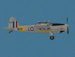
Repaint of FSDS Chipmunk by Rick Piper, Dave Booker, David Maltby and Saverio Maurri representing VH-ZIZ, a South Australian Chipmunk owned and flown by Mike Hannell, and frequenting Parafield YPPF.
| Filename: | de_Havilland_Canada_DHC1_Chipmunk_VHZIZ.zip |
| License: | Freeware, limited distribution |
| Added: | 5th October 2011, 01:15:37 |
| Downloads: | 179 |
| Author: | John Burford |
| Size: | 1.1 MB |
| Category: Flight Simulator X - Scenery | |
| Wind power generators St-Robert, Quebec, Canada |
|
Images related to this file:
File Description:
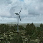
Wind power generators project at Saint-Robert-Bellarmin, build by "Saint-Laurent energies". REQUIRES: qc38m_fsx_1de5.zip, qc38m_fsx_2de5.zip, qc38m_fsx_3de5.zip, qc38m_fsx_4de5.zip, qc38m_fsx_5de5.zip
| Filename: | Wind_power_generators_StRobert_Quebec_Canada.zip |
| License: | Freeware |
| Added: | 30th December 2011, 17:14:50 |
| Downloads: | 289 |
| Author: | Daniel Leclerc |
| Size: | 1.59 MB |
| Category: Flight Simulator X - Scenery | |
| Wind power generators "erable" area, Quebec, Canada |
|
Images related to this file:
File Description:

Wind power generators project Saint-Ferdinand and Saint-Pierre-Baptiste. REQUIRES: qc38m_fsx_1de5.zip, qc38m_fsx_2de5.zip, qc38m_fsx_3de5.zip, qc38m_fsx_4de5.zip, qc38m_fsx_5de5.zip
| Filename: | Wind_power_generators_erable_area_Quebec_Canada.zip |
| License: | Freeware |
| Added: | 30th December 2011, 17:15:46 |
| Downloads: | 307 |
| Author: | Daniel Leclerc |
| Size: | 1.66 MB |
| Category: Flight Simulator X - Aircraft Repaints, Textures and Modifications | |
| De Havilland Canada DHC-6 Twin Otter |
|
Images related to this file:
File Description:
This is a repaint of the De Havilland Canada DHC-6 Twin Otter. Created for Graham Mithael, CEO of Pacific Island Simulations. JPG's used on this aircraft were provided by Graham. This repaint is the work of Ken Alger. This version of the Otter is published by Aerosoft and is required for installation.
| Filename: | De_Havilland_Canada_DHC6_Twin_Otter.zip |
| License: | Freeware |
| Added: | 25th February 2012, 16:33:56 |
| Downloads: | 428 |
| Author: | Ken Alger, Aerosoft |
| Size: | 2.03 MB |
| Category: Flight Simulator 2004 - Scenery | |
| Updates for Rockcliffe CYRO in Ottawa Canada |
|
Images related to this file:
File Description:
Flight Ontario posted their scenery for CYRO in 2008. I originally learned to fly at Rockcliffe Flying Club and came up with some additions and modifications in 2009, and now with the passage of time there are more changes. This version replaces the previous updates and is a self-contained version.
A mini tornado in 2009 destroyed the old willow tree and almost put paid to the clubhouse too (though all the buildings are still standing right now) so there is a new (temporary) clubhouse, a new hangar, the willow tree is gone, the car park is enlarged and is now asphalt, the fence line is revised and the entrance gate relocated. The previous modifications included the refueling point near the RFC buildings, revised apron shape, gravel car park, parked cars, extended perimeter fence, deck in front of the RFC clubhouse, more parked planes, the large and old willow tree, and the float dock in the river. Note in the winter picture the Ottawa River is frozen, as it is right now in reality, and you can download my "Frozen Lakes etc" post and turn your own Canadian winter into reality; I have been surprised by how few people are interested in winter flying in FS9.
| Filename: | Updates_for_Rockcliffe_CYRO_in_Ottawa_Canada.zip |
| License: | Freeware, limited distribution |
| Added: | 5th March 2010, 18:05:35 |
| Downloads: | 567 |
| Author: | Roger Wensley |
| Size: | 2.43 MB |
| Category: Flight Simulator 2004 - Scenery | |
| Lady Franklin Point CWLF in Nunavut, Canada |
|
Images related to this file:
File Description:
Lady Franklin Point was a DEW line station on the southwest corner of Victoria Island, and then a North Warning System station until January 2000 when there was a fire. As a result there are now no NWS buildings, and no central long DEW line station building, only the outlying and already unused buildings from the DEW line site. However, the runway is still there and over 5,000 feet of gravel in length, aligned and signed 90T/270T, though on the atc it will be called 55/235 as FS9 knows nothing about the Canadian Northern Domestic Airspace. There is no runway lighting. Kugluktuk is around 80 miles to the southwest, on the mainland.
I should have mentioned a long time ago that to see the apron lights working (on my fields that HAVE apron lights) requires you to have the "lights_ss_v2" by Sidney Schwartz installed.
| Filename: | Lady_Franklin_Point_CWLF_in_Nunavut_Canada.zip |
| License: | Freeware, limited distribution |
| Added: | 10th November 2012, 04:04:06 |
| Downloads: | 259 |
| Author: | Roger Wensley |
| Size: | 1.81 MB |
| Category: Flight Simulator 2004 - Scenery | |
| Puvirnituq CYPX in Hudson Bay, Quebec, Canada |
|
Images related to this file:
File Description:
Puvirnituq is a village of 1,300 or so inhabitants at N60 W77 on the east shore of Hudson Bay. It's name means "Putrid" in Inuit, and there are two different stories about how it got the name. The village does not feature in FS9, but is included in this scenery with approximately the right shape (the coast, even with UT, is not exactly right) so just think of it as a hand-made auto-generated village which gives the airfield a reason for being there. The runway is a very generous 6,300 feet of gravel 148 feet wide, which should be enough for almost anything. I also had to add the roads, delete the stock airfield background and add a new background, plus of course there is the scenery file and the AFCAD and AI.
| Filename: | Puvirnituq_CYPX_in_Hudson_Bay_Quebec_Canada.zip |
| License: | Freeware, limited distribution |
| Added: | 30th October 2010, 13:34:30 |
| Downloads: | 375 |
| Author: | Roger Wensley |
| Size: | 1.72 MB |
| Category: Flight Simulator 2004 - Scenery | |
| Haines Junction CYHT in Yukon Territory Canada |
|
Images related to this file:
File Description:
Haines Junction is a village in the Yukon Territory, Canada, amid the Rocky Mountains and around 80 miles west of Whitehorse. It is sited at the junction of the Haines Highway and the Alaska Highway, hence the name. The village was established in 1942 when the Alaska Highway was under construction, and the Haines Highway was built over the Chilkat Pass to connect to the town of Haines on the Alaska coast.
The date of this scenery is, as usual, around 2010. At that time there was a regular service (not always a daily one, depending on the time of year) by Yukon Air North, and in this case it is by an ATR 42-300. There is a helicopter company based at the airfield, Trans North Helicopters, and there is also Kluane Glacier Air Tours, which, as the name suggests, takes you to a glacier so you can stroll around on ice. And then brings you back. The gravel runway is 5,000 feet long and aligned 04-22, and is lit, with PAPI at both ends. Right hand circuits are required for runway 04 as the terrain is not flat.
This post will be followed by two other airfields to the northwest, Silver City and Burwash, both of which are on or close to the Alaska Highway.
| Filename: | Haines_Junction_CYHT_in_Yukon_Territory_Canada.zip |
| License: | Freeware, limited distribution |
| Added: | 22nd January 2022, 21:53:16 |
| Downloads: | 115 |
| Author: | Roger Wensley |
| Size: | 20.46 MB |
© 2001-2026 AVSIM Online
All Rights Reserved
Privacy Policy |