
Where Flight Simulation Enthusiasts Gather from Around the World!
AVSIM Library - Search Results

| Category: Flight Simulator 2004 - Aircraft Repaints, Textures and Modifications | |
| Sata International Airbus A310-325ET New Colours |

|
Images related to this file:
File Description:

HNAC Airbus A310-325ET repainted in Sata International new livery. Works with FS2004. Installation instructions included.
| Filename: | Sata_International_Airbus_A310325ET_New_Colours.zip |
| License: | Freeware |
| Added: | 14th October 2010, 20:32:39 |
| Downloads: | 1,001 |
| Author: | Tiago Palla |
| Size: | 4.92 MB |
| Category: Flight Simulator 2004 - Aircraft Repaints, Textures and Modifications | |
| Airbus A319 Royal Jordanian JY-AYC |
|
Images related to this file:
File Description:

Royal Jordanian JY-AYC for Project Airbus' A319 model! painted by HT Repaints, model no included!
| Filename: | Airbus_A319_Royal_Jordanian_JYAYC.zip |
| License: | Freeware |
| Added: | 19th February 2020, 01:27:30 |
| Downloads: | 315 |
| Author: | HT Repaints |
| Size: | 8.75 MB |
| Category: Flight Simulator 2004 - Aircraft Repaints, Textures and Modifications | |
| TAP Portugal - Airbus A320-200 |
|
Images related to this file:
File Description:

TAP Portugal Airbus A320-200 for the Airsimmer model. CS-TNV (MSN 4145 - SelCal BK-CD).
| Filename: | TAP_Portugal__Airbus_A320200.zip |
| License: | Freeware |
| Added: | 20th February 2010, 01:53:22 |
| Downloads: | 803 |
| Author: | Andre Moniz |
| Size: | 4.28 MB |
| Category: Flight Simulator 2004 - Original Aircraft | |
| Hawaiian Airlines Airbus A330-200 RR |
|
Images related to this file:
File Description:
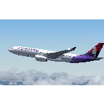
Hawaiian Airlines new Airbus A330-200 RR. Textures by Hernan Anibarro. Model by Project Opensky, Included.
| Filename: | Hawaiian_Airlines_Airbus_A330200_RR.zip |
| License: | Freeware |
| Added: | 10th April 2010, 03:00:54 |
| Downloads: | 4,653 |
| Author: | Hernan Anibarro / Project Opensky |
| Size: | 33.15 MB |
| Category: Flight Simulator X - AFCAD Files | |
| LQSA - Sarajevo Intl. Airport, Bosnia Herzegovina |
|
File Description:
Sarajevo International Airport (IATA: SJJ, ICAO: LQSA), also known as Butmir Airport, is the main international airport in Bosnia and Herzegovina, located 3.3 NM (6.1 km; 3.8 mi) southwest of the railway station in the capital city of Sarajevo in the suburb of Butmir. Since the Dayton Accord in 1996, the airport has welcomed a thriving commercial flight business which includes B&H Airlines, Austrian Airlines, Lufthansa, Jat Airways, Croatia Airlines, Turkish Airlines, Germanwings and others. In 2006, 466,186 passengers traveled through Sarajevo airport, compared to only 25,000 in 1996. In 2011 Sarajevo International Airport had 599,996 passengers which is more than all of the airports in Bosnia-Herzegovina had together and 6,5% more than in 2010. In 2012 the company has a slight decline in traffic. In 2005 the European branch of the Airports Council International awarded Sarajevo the award of Best Airport Under 1 Million Passengers. I just land in this airport, thank you to Sarajevo approach for a nice job. This file has the right coordinates, with runway 46 meters wide, apron and characteristics of the airport, airport vehicles and buildings.
| Filename: | LQSA__Sarajevo_Intl_Airport_Bosnia_Herzegovina.zip |
| License: | Freeware |
| Added: | 10th November 2012, 22:52:51 |
| Downloads: | 2,138 |
| Author: | Anwar Gonzalez |
| Size: | 4.44 MB |
| Category: Miscellaneous Files - General Utilities | |
| Professional Flight Planner X (PFPX) Boeing 767-300ER Winglets (WL) Performance Profiles Pack Version 1.1 |
|
Images related to this file:
File Description:

PFPX performance profiles for the complete family of wingleted variants of Boeing 767-300ER with winglets with all available engines for real-world operators. Multiple engine out schedules and all engine schedules, mach numbers and cost index data.
For use with Level-D 767-300ER Winglets model.
See Readme.txt for details.
| Filename: | Professional_Flight_Planner_X_PFPX_Boeing_767300ER.zip |
| License: | Freeware |
| Added: | 12th July 2015, 18:06:01 |
| Downloads: | 954 |
| Author: | Mykyta Demydiuk | FlyPrecisely |
| Size: | 1.4 MB |
| Category: Flight Simulator X - Utilities | |
| FS Earth 5.0 for Google Earth |
|
File Description:
This program acts as an interface between Flight Simulator X and Google Earth, letting to follow a flight in real time, over the satellite images generated by Google Earth. Flights can be saved, and many options are available for fine tuning the performance, as well as the map's style (zoom, tilt, orientation). Works on a single computer running FSX and Google Earth all together or, for best experience, can be used on two networked computers running respectively FSX (master) and Google Earth (slave). AI and Multiplayer traffic is also displayed in Google Earth, with course prediction and other information. Requires Flight Simulator X and Google Earth. The program running in trial mode works only around Anchorage, Alaska, (PANC / ANC) for a maximum of five minutes per flight session. Version 5.0 has improved compatibility with latest releases of Google Earth and several additional improvements. A version for FS2004 is available also.
| Filename: | FS_Earth_50_for_Google_Earth.zip |
| License: | Shareware, time limited |
| Added: | 19th July 2007, 00:46:27 |
| Downloads: | 1,104 |
| Author: | Luciano Napolitano |
| Size: | 2.44 MB |
| Category: X-Plane - Aircraft Repaints, Textures and Modifications | |
| Bergamo Aero Club Cessna 172N Skyhawk II (I-CCAP) |
|
Images related to this file:
File Description:

This archive only contains textures for the Carenado 172II V2 aircraft. In order for it to work, you need to own this specific aircraft. Since these are only textures, no further support is necessary, just follow the instructions below.
*** I have included a .obj file that Dan Klaue provided to fix a small problem causing wing registrations to display incorrectly. The filename is TransparentStickers.obj. You must copy this file to the aircraft's main objects folder of the Carenado C172II v2 main folder. You will be asked if you want to replace the existing file, say yes. Make a backup of the original first. This file will enable the under-wing registration of the aircraft.
Then open the zip file and move the whole folder I-CCAP to X-Plane 10 (where you installed X-Plane)--->Aircraft-->Carenado Cessna 172 v2 (where you installed the Carenado package)--->liveries. That's it!
| Filename: | Bergamo_Aero_Club_Cessna_172N_Skyhawk_II_ICCAP.zip |
| License: | Freeware, limited distribution |
| Added: | 16th June 2013, 02:23:15 |
| Downloads: | 98 |
| Author: | Michel Theriault |
| Size: | 14.82 MB |
| Category: Flight Simulator X - AFCAD Files | |
| PASD - Sand Point, Alaska |
|
Images related to this file:
File Description:
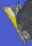
The airport of Sand Point (PASD) has been extended since Microsoft has modeled it and even after the upgrade through Scenery Solution's Ultimate Terrain X Alaska has been produced. This AFCAD is built on the UTX version of the airport and is intended to be used in this environment only.
The file considers the extended runway, VASI4 at both ends with 3.6 deg glideslope and the necessary new water-polygon. Due to the specific coastline bitmaps used by UTX I had to change to Microsoft's default ones being accessible through the wonderful tool Airport Design Editor X. Some additional landclass in the airport's vicinity and three (default) buildings close to the apron are completing the changes. I did not touch the easterly landing stage (or whatever it could have been) even if Google suggests that it disappeared meanwhile except some remaining piles in the water - it's just looking nice. ;-)
| Filename: | PASD__Sand_Point_Alaska.zip |
| License: | Freeware |
| Added: | 17th October 2013, 18:55:00 |
| Downloads: | 377 |
| Author: | Axel Birsul |
| Size: | 646.25 KB |
| Category: Flight Simulator X - Utilities | |
| FS Earth 5.2 for Google Earth and FSX |
|
Images related to this file:
File Description:

This program acts as a link between Flight Simulator X and Google Earth, letting to follow a flight in real time, over the satellite images generated by Google Earth. Flights can be saved, and many options are available for fine tuning the performance, as well as the map's style (zoom, tilt, orientation). Works on a single computer running FSX and Google Earth all together or, for best experience, can be used on two networked computers running respectively FSX (master) and Google Earth (slave). AI and Multiplayer traffic is also displayed in Google Earth, with course prediction and other information. Requires Flight Simulator X and Google Earth. The program running in trial mode works only around Anchorage, Alaska, (PANC / ANC) for a maximum of five minutes per flight session. Version 5.2 has new aircraft icons & labels and improves the compatibility with Windows Vista. A version for FS2004 is available also.
| Filename: | FS_Earth_52_for_Google_Earth_and_FSX.zip |
| License: | Shareware, time limited |
| Added: | 3rd May 2010, 07:38:23 |
| Downloads: | 2,701 |
| Author: | Luciano Napolitano |
| Size: | 3.46 MB |


© 2001-2026 AVSIM Online
All Rights Reserved
Privacy Policy |