
Where Flight Simulation Enthusiasts Gather from Around the World!
AVSIM Library - Search Results

| Category: Flight Simulator 2004 - Scenery | |
| UK Hospitals (Vol 1) |

|
File Description:
This scenery collection contains airfield data for 54 Helipad landing sites in Wales, Lancashire, Merseyside, Cheshire and Cumbria based on the information provided by the Confederation of Helicopter Ambulance Services. Information here http://www.chasuk.co.uk/Documentation/HospitalLandingSites/tabid/69/Default.aspx.
The scenery is intended to be used in FS2004 Century of Flight with Just Flight's VFR photographic VFR scenery installed. The height data from CHASUK has been ignored in favour of that obtained from the Just Flight default mesh.
I have started to add autogen trees etc. around some of the landing sites - but this takes a lot longer and so I'm issuing vol 1 first with autogen only added to a few of the sites in the Chester/Merseyside area.
| Filename: | UK_Hospitals_Vol_1.zip |
| License: | Freeware |
| Added: | 2nd April 2009, 16:44:10 |
| Downloads: | 1,101 |
| Author: | Russ McGinn |
| Size: | 231.54 KB |
| Category: Flight Simulator X - Scenery | |
| Flags and Signs |
|
File Description:
This package provides a little collection of flags and signs for scenery designers for FSX. The models have been developed with GMAX. Along with the textures the package includes the mdl files, and the XML files for the individual placement of the objects into a scenery. The bgl files are included as well.
The documentation (see pdf file in the ZIP) contains a step by step description on how to place the objects into the FSX scenery. A gauge for a proper positioning of the objects is part of the package.
CREDIT goes to:
Bob Familton for spending his time on review the package and the documentation.
Gary Mills, Robert Finnegan, Kevin Bryan, for the helpful package chplus.zip,
and Jim Robinson for the helpful package ch_pnl.zip .
| Filename: | Flags_and_Signs.zip |
| License: | Freeware |
| Added: | 18th February 2010, 04:16:51 |
| Downloads: | 638 |
| Author: | Dietmar Loleit |
| Size: | 1.71 MB |
| Category: Flight Simulator 2004 - Scenery | |
| Ko Samui, Thailand (VTSM) v4.0 |
|
File Description:
Samui is a small, but busy airport on the island of Ko Samui. It is located in Southern Thailand, and is an exotic resort destination. In 1989 Bangkok Airways opened their own airport on the island, which decreased the travel time from Bangkok considerably. The airport is currently served by Bangkok Airways, although an occasional private aircraft will land here. This scenery is a detailed and accurate representation of this airport as it looks today. I consulted with several visitors to the airport, as well as the AIP for Thailand. Landsat imagery was used to modify the shoreline, and a custom landclass is included. Taxiway and parking areas were modified by using AFCAD2. This scenery is compatible with 3rd-party mesh scenery for Thailand.
| Filename: | Ko_Samui_Thailand_VTSM_v40.zip |
| License: | Freeware, limited distribution |
| Added: | 25th April 2004, 21:10:31 |
| Downloads: | 11,746 |
| Author: | Martin Strong |
| Size: | 5.34 MB |
| Category: Flight Simulator X - Scenery | |
| UTFN - Namangan, Uzbekistan |
|
Images related to this file:
File Description:
This is fictional scenery for Namangan (UTFN), Uzbekistan, designed for FSX.
I created this scenery to be more representative of the real life airport. I accomplished this by making modifications to the stock airport, using Google Satellite images and pictures for guidance. Also pictures of the terminal when they are available.
Here is what to look for in this scenery package:
- Added a custom made terminal as depicted in actual airport pictures.
- Added apron and taxiways as depicted in the actual airport pictures.
- Added a couple of hangers and SU-35 aircraft parked on the apron.
- Added a fire station and Control Tower.
- Flattened the terrain on the runway because part of the it was underground.
- Deleted a few trees on both approaches.
| Filename: | UTFN__Namangan_Uzbekistan.zip |
| License: | Freeware |
| Added: | 28th May 2014, 10:56:00 |
| Downloads: | 554 |
| Author: | Ed Bleck |
| Size: | 1.14 MB |
| Category: Flight Simulator 2004 - Scenery | |
| CYWG Winnipeg 2020 |
|
Images related to this file:
File Description:
CYWG is an international airport located in the city of Winnipeg, which is the capital of the Province of Manitoba, in the western part of Canada. This scenery provides an accurate depiction of CYWG for Flight Simulator FS2004. It includes the entire airport as well as many of the surrounding industrial and warehouse buildings. The scenery includes static aircraft, an extensive array of ground support equipment representative of types and operators at CYWG, vibrant night lighting and seasonal texture variations.
CYWG WINNIPEG 2020 is a very detailed scenery best run on a higher-end PC. To make the airport more flyable for a greater range of FS9 users, CYWG Winnipeg comes packaged with options for three editions and ability to turn certain features on and off.
| Filename: | CYWG_Winnipeg_2020.zip |
| License: | Freeware, limited distribution |
| Added: | 6th July 2020, 18:19:02 |
| Downloads: | 1,646 |
| Author: | Gregory Putz |
| Size: | 104.68 MB |
| Category: Flight Simulator 2004 - Scenery | |
| Merrill Field PAMR 2016 V3 in Anchorage, Alaska, including the Fedex 727 |
|
Images related to this file:
File Description:
This V3 version of Merrill Field 2016 finally adds the Fedex 727 to Merrill Field, the error being totally mine but left as unreported by all but two of the downloaders. Testing on the computer of one of the reporting downloaders solved the problem, and revealed the requirement to have the aircraft "installed" on every user's computer. This was unknown by me, and not "testable" on my computer for obvious reasons. Which is why I need user input!?! Only 2 out of a total of around 500 downloaders? This is not a stand-alone scenery. Put the Fedex727.bgl into the scenery folder of your downloaded Merrill Field V2 and the 727 will be visible. You already have the textures in the scenery texture folder.
| Filename: | Merrill_Field_PAMR_2016_V3_in_Anchorage_Alaska_inc.zip |
| License: | Freeware, limited distribution |
| Added: | 3rd October 2016, 21:38:27 |
| Downloads: | 481 |
| Author: | Roger Wensley |
| Size: | 406.97 KB |
| Category: Prepar3D V1-4 - Scenery | |
| KILE, Killeen Texas airport |
|
Images related to this file:
File Description: Instructions: There are 3 folders in this package; effects, scenery and texture.
Create a subfolder under the C:\Program Files (x86)\Lockheed Martin\Prepar3D v3\Scenery folder and call this new folder KILE.
Place the scenery and texture folders (with their associated contents) under this newly created KILE subfolder.
Place only the contents (not the folder) of the effects folder in the P3D effects folder often located at C:\Program Files (x86)\Lockheed Martin\Prepar3D v3\Effects.
Now start up P3D.
On the menu at the top of the P3D screen click on World > Scenery Library > Add Area. This will bring up the Add Scenery Area dialog box. Click the Browse button and browse to find the newly created KILE folder. It should be located at C:\Program Files (x86)\Lockheed Martin\Prepar3D v3\Scenery. Once you select the KILE folder, click the OK button. This will place that folder in the P3D scenery library. You will notice that the library is organized by priority starting at 1. I have my KILE scenery set as #4 priority but I am not sure if it needs to be that high. I did notice during design that sometimes my ground texture at the airport would act strange and I found that by setting KILE to a higher priority, it fixed that. As a last step make sure the checkbox to enable the scenery is checked and click OK.
You should now have the new KILE scenery available to use.
This package covers KILE, Killeen Texas airport. It is a city owned public use airport located 3 miles east of Killeen Texas. It has one runway that is 5,495 x 100 feet.
Almost 100 custom objects are included in this package. They include:
All hangers and buildings on the airport grounds made from on site photos.
Several buildings surrounding the airport grounds.
All taxiway and runway signs.
All taxiway, runway and approach lighting.
ILS antenna, localizer, etc.
Fuel tanks and parking T's.
Night lighting where appropriate.
Currently I am using the default land class instead of photo real because I couldn't find any photo real that suited my needs.
I welcome your feedback good or bad. Currently this airport is only for P3D. I may create an FSX version if I have enough requests. I started learning to make 3d objects and airports last year and I am learning something new every day. I hope you enjoy!
I plan on improving the night lighting for the runway lights, runway end lights, taxiway lights, etc. to make them more visible from a distance at night. I also want to replace the stock P3D vehicles with my own design and a few other things to come in an updated version down the road.
| Filename: | KILE_Killeen_Texas_airport.zip |
| License: | Freeware |
| Added: | 11th May 2017, 19:54:19 |
| Downloads: | 492 |
| Author: | Shannan Landreth |
| Size: | 23.83 MB |
| Category: Dovetail Games Flight Sim World - Scenery | |
| SEATTLE X DEMO - the City and the Airports |
|
Images related to this file:
File Description:
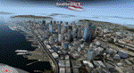
SEATTLE X DEMO features an extremely detailed scenery of large area of Seattle, USA, fully compatible with FSX, FSX SE, P3D v1/v2/v3/v4 and FSW by Dovetail.
With Seattle X you are free to fly to any of 5 airports: KSEA Tacoma, KPAE Paine Field, KBFI Boeing Field, KRNT Renton, S50 Auburn, admire some of the world-renowned landmarks, bridges, harbours, heliports, seaplane bases, ships, etc.
This Demo version features both - the City and the Airports packages (commercial poducts) and includes some downtown buildings as well as all airports with terminals but with low resolution textures, non-animated jetways and generally much less details. This ensures no problems with online (VATSIM, IVAO and multiplayer) flying in case some users have the payware scenery and some don't.
It's equipped with an automatic installer, which means that the scenery will be automatically added to the Flight Simulator Scenery Library.
Please uninstall all previous versions of the above-mentioned airports you may have installed before. Please make also sure that no duplicated AFCAD files are installed.
Enjoy your virtual flying with Drzewiecki Design!
| Filename: | SEATTLE_X_DEMO__the_City_and_the_Airports.zip |
| License: | Freeware, limited distribution |
| Added: | 1st May 2018, 15:53:13 |
| Downloads: | 105 |
| Author: | Drzewiecki Design |
| Size: | 90.12 MB |
| Category: Prepar3D V1-4 - Scenery | |
| EPKK KRAKOW BALICE X V2 DEMO |
|
Images related to this file:
File Description:
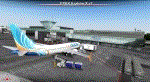
EPKK KRAKOW BALICE X V2 DEMO features the scenery of EPKK Krakow Balice airport and Krakow City, Poland, fully compatible with FSX, FSX:SE, FSW, P3Dv1-v4.
It's a fully functional DEMO version of the commercial payware product. It features same airport layout as in the full version but with limited 3D objects and low resolution textures. Using this free demo ensures no problems with online (VATSIM, IVAO, multiplayer etc.) flying in case some users use the payware scenery and some don't.
John Paul II International Airport Krakow-Balice (KRK / EPKK) is an international airport located near Krakow, in the village of Balice, 11 km (6.8 mi) west of the city centre, in southern Poland. The airport has one concrete runway, number 07/25, 2550x60m.
It's equipped with an automatic installer, which means that the scenery will be automatically added to the Flight Simulator Scenery Library.
Please uninstall all previous versions of this airport you may have installed before. Please make also sure that no duplicated AFCAD files are installed.
Enjoy your virtual flying with Drzewiecki Design!
| Filename: | EPKK_KRAKOW_BALICE_X_V2_DEMO.zip |
| License: | Freeware, limited distribution |
| Added: | 22nd November 2018, 00:56:01 |
| Downloads: | 521 |
| Author: | Drzewiecki Design |
| Size: | 12.67 MB |
| Category: Flight Simulator X - AFCAD Files | |
| Warren Grove Range Airport (NJ24), New Jersey |
|
File Description:
Located 03 miles SW of Burlington County, New Jersey, Warren Grove Range is a private concrete airfield 1800' in length. It is owned by the Department of Defense and exists in a restricted flight area. The bare sand of this area has washed out the satellite images tremendously from over-exposure thanks to reflected sunlight - you can't even make out the runway (which FSX places incorrectly over a mile away). Due to lack of ground definition and primary use as a military facility, this airport has not been developed by MSEAirports and the concrete runway has been removed.
Scenery constructed with use of satellite images/streetview/aerial photos - the author has not been there in person.
This scenery is meant to be used in conjunction with MegaScenery Earth New Jersey/Delaware 003. It is not required, but apron use is minimized to allow satellite scenery to show through as much as possible, and objects are placed based on the MSE textures - lack of it may make scenery look out of place.
| Filename: | Warren_Grove_Range_Airport_NJ24_New_Jersey.zip |
| License: | Freeware |
| Added: | 20th August 2011, 19:58:05 |
| Downloads: | 174 |
| Author: | Drew Sikora |
| Size: | 153.47 KB |


© 2001-2026 AVSIM Online
All Rights Reserved
Privacy Policy |