
Where Flight Simulation Enthusiasts Gather from Around the World!
AVSIM Library - Search Results

| Category: Flight Simulator 2004 - Scenery | |
| Akulivik CYKO in northern Quebec Canada |

|
Images related to this file:
File Description:
This is another of the many airfields that are all around the coast of Hudson Bay, this one being on the eastern, Quebec side. Akulivik is around 110 miles south of Ivujivik, which is on the northeastern corner of the Bay, and some 60 miles north of Puvirnituq. The population is 630 or so and the village grew from a move back to the area by one family in 1973, followed by others in the following years; the closure of the Hudson Bay trading post post in 1952 had pushed all residents to move south to Puvirnituq. The village is unusual in that it has a built harbour instead of the usual beached storage of boats. The village is built on the central prong of a three pronged spear of headlands (from which the village name is derived) while the airfield is a mile or so further inland. I have no information regarding what I think may be a new terminal building, so this includes only the old original one. The runway is just under 3,500 feet of gravel aligned 09-27, and the ai includes the scheduled flight by an Air Inuit Dash 8-300, plus GA.
| Filename: | Akulivik_CYKO_in_northern_Quebec_Canada.zip |
| License: | Freeware, limited distribution |
| Added: | 9th September 2018, 03:43:25 |
| Downloads: | 162 |
| Author: | Roger Wensley |
| Size: | 4.69 MB |
| Category: Flight Simulator 2004 - AI Aircraft | |
| Republic F-105 Thunderchief (Part 1) |
|
Images related to this file:
File Description:

Republic F-105 Thunderchief. This is another Jake Burrus aircraft I have been able to bring to the flightsim world. Originally introduced in 1958 as a low-level nuclear weapons delivery aircraft in the middle of the Cold War, this aircraft became the backbone of conventional bombing during most of the Vietnam War. As a testament to the aircraft's role, the bravery of its pilots, and the ferocity of the North Vietnamese air defense network, nearly half of the 833 airframes were lost in combat operations. Due to the extensive combat use of the Thud, it had a relatively short service life, with limited use after Vietnam, until the aircraft's final retirement in 1984.
This is part 1 of 2 parts, and represents the use of the F-105B/D/F from 1958-1966; to include 16 model variants and 131 repaints; but includes all of the F-105B units including those used post-Vietnam by ANG and AFRES units. Aircraft model by Jake Burrus and Mike Pearson, master textures and repaints by Mike Pearson, flight dynamics by Mike MacIntyre. Please read the documentation contained in the file.
| Filename: | Republic_F105_Thunderchief_Part_1.zip |
| License: | Freeware |
| Added: | 29th December 2013, 20:17:48 |
| Downloads: | 578 |
| Author: | Michael Pearson |
| Size: | 39.7 MB |
| Category: Flight Simulator 2004 - Scenery | |
| CZFN - Tulita - Northwest Territories, Canada |
|
Images related to this file:
File Description:
Tulita (Fort Norman until 1996) is another in the series of airfields that follow (approximately) the Mackenzie River. At the far northern end of the river and on the eastern side of the delta there is Tuktoyaktuk, then Inuvik, Fort McPherson, Fort Good Hope, Deline, Wrigley, Fort Simpson Island and Fort Simpson, and then Fort Liard at the southern end of the list of those in the Northwest Territories. South of Fort Liard there are Peace River and Dawson Creek, both of which are already posted. Tulita is at the junction of the Mackenzie and Great Bear Rivers, on the east bank of the Mackenzie and the south bank of the Great Bear, around 40 miles southeast of Norman Wells. The town has a population of about 480 folks. The airport is above and to the east of the town, and has 3,000 feet of gravel runway. The scheduled flights are by North Wright and I have also added a Buffalo DC3 and GA. There is a mandatory radio frequency but in this case I have set the "tower" to "unmanned" so you will report position and intentions. There is no fuel available.
| Filename: | CZFN__Tulita__Northwest_Territories_Canada.zip |
| License: | Freeware, limited distribution |
| Added: | 12th July 2014, 08:05:54 |
| Downloads: | 272 |
| Author: | Roger Wensley |
| Size: | 2.66 MB |
| Category: Flight Simulator 2004 - Scenery | |
| Port McNeill CAM8 float base in British Columbia, Canada |
|
Images related to this file:
File Description:
This is the seventh in a series of new and renovated float bases in BC. Port McNeill is a float base in a sheltered inlet on the northeast coast of Vancouver Island, close to the town and just under 20 miles east of the Port Hardy float base. There is no fuel available as the Port Hardy floatbase (already posted) acts as a refuelling centre for this and other float bases in the neighbourhood. The dock is to the west of the marina and east of the log raft area. The AI is a further adaptation of the CF36 AI and involves Beavers as listed in the AI folder. At Port McNeill all the AI works for both landing and takeoff for all of the planes, no matter what the wind direction is. All of these float bases can be installed together in the same folders, with a saving in duplicate textures. So a series called BC Floats (or whatever you want to call it) or individually installed float bases; your choice. The next in the series was suposed to be Sullivan Bay, another floating marina, but I digressed to Port Hardy and Port McNeill.
| Filename: | Port_McNeill_CAM8_float_base_in_British_Columbia_C.zip |
| License: | Freeware, limited distribution |
| Added: | 21st January 2017, 19:11:03 |
| Downloads: | 171 |
| Author: | Roger Wensley |
| Size: | 5.07 MB |
| Category: Flight Simulator 2004 - Scenery | |
| Alaska North Slope 6; Oliktok POLI |
|
Images related to this file:
File Description:
Oliktok is a DEW station Air Force base to the east of the Colville River delta, 160 miles east of Barrow and 12 miles from Harmon Helmericks house and dirt strip in the delta on Anachlik Island. (See my previous post, made after reading his book about northern Alaska flying). The runway is just over 4,000 feet of gravel and aligned 03-21. The large hangar is still there, and so are the majority of the DEW buildings closer to the beach. There are now also some oil production facilities and living quarters nearby on the point, but these are not included in this scenery as to make them convincingly (and there is no point in making them unconvincingly!) would be 100+ times as laborious as making the airstrip. And as Sid has memorably said, "If you can't taxi up to it, then xxxx it". So this scenery is dated way before the north slope was changed from a wilderness to an industrial complex. The AI is one day a C-130, on another a Cessna, and on a third a Reeve Aleutian DC-6B.
| Filename: | Alaska_North_Slope_6_Oliktok_POLI.zip |
| License: | Freeware, limited distribution |
| Added: | 30th June 2016, 20:36:34 |
| Downloads: | 281 |
| Author: | Roger Wensley |
| Size: | 2.42 MB |
| Category: Flight Simulator 2004 - Scenery | |
| Colville Lake CEB3 in Northwest Territories Canada |
|
Images related to this file:
File Description:
Colville Lake is a small village of around 150 Dene, located to the northwest of the Great Bear Lake and east of the Mackenzie River, 120 miles north of Norman Wells. The village and the airfield are next to each other and to the lake shore. I recently discovered which of the standard terminal buildings had been used there and this, along with information I already had, enabled me to now make the scenery, which is based on an approximate 2010 date. The gravel runway is lit and around 2,800 feet long, aligned 10-28. North Wright Air serves the village from it's headquarters at Norman Wells with daily flights by de Havilland Twin Otters, or "twotters" as they were quickly named among the northern Canadian airline personnel when they were first produced. The approximate time of this scenery is 2010. While testing this scenery I discovered that Tulita (previously called Fort Norman) which is another Mackenzie River airfield to the south of Norman Wells, needs to be reposted due to a terrain fault. If you find an error here then email me please, and note that my email address has been changed to rogwens at Gmail dot com.
| Filename: | Colville_Lake_CEB3_in_Northwest_Territories_Canada.zip |
| License: | Freeware, limited distribution |
| Added: | 31st July 2021, 18:23:48 |
| Downloads: | 69 |
| Author: | Roger Wensley |
| Size: | 4.51 MB |
| Category: Flight Simulator X - AFCAD Files | |
| ZSGS - Zhuhai Janwan Airport - Zhuhai, China |
|
File Description:
The Zhuhai Sanzao airport (ZGSD/ZUH, China), close to Macao, was built on request of someone who found it included in the FMC of PMDGs 737NGX, but missed in FSX. I used ADE and the Google based old version 2 of Plan-G (thanks to both authors) and some charts being available in the internet. However, it is equipped with standard buildings which are roughly adapted to the real dimensions well. Lighting, windsocks, taxisigns and moving jetways. Of course I added both ILS as well. There is a big exhibition apron on the airport which is modeled but blocked for AI traffic. You will see the lines of the taxiways nevertheless. The latest temporary chart (Nov 2012) shows a third apron which is not realised and I'm not planning to do so (obviously the whole site is still under construction).
As being built on a FSX island (which is now a peninsula) and default coast lines not fitting to the real position of the airport (Rwy05 was hanging in the water) I decided to compromise in a way that I corrected the area in the vicinity of the airport but respected the remaining part as it was in the default scenery. The attached pictures should give an impression even if I'm not using the pure default scenery. Therefore this little patch should be compatible to advanced mesh sceneries.
| Filename: | ZSGS___Zhuhai_Janwan_Airport__Zhuhai_China.zip |
| License: | Freeware |
| Added: | 2nd May 2013, 07:56:18 |
| Downloads: | 688 |
| Author: | Axel Birsul |
| Size: | 614.11 KB |
| Category: Flight Simulator X - Original Aircraft | |
| HMS Bounty for FSX - VERSION 1.1 |
|
Images related to this file:
File Description:
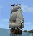
HMS Bounty for FSX - VERSION 1.1 - Built Specifically for FSX - (separate package required for FS9) by Milton Shupe, Nigel Richards, Rob Barendregt, Sasha Rieger, and Rob Ibey. Helmsman by Craig "Full" Richardson.
HMS Bounty 18th Century Tall Ship square rigger completely wind driven, individually animated and controlled sails, animated flags with direction and wind speeds, animated helm, and Sail Management Window to control all ship functions. Ship responds to wind speeds and direction with yaw, keeling, and pitch depending on sails deployed and yard arm positions. Ambient sounds, variable wind and gale storm sounds, ship's bell, "Salute", anchor weigh/drop all add to immersion.
WILL NOT WORK IN FS9 as it contains FSX native texture formatting and FSX specific sim interfaces. (Separate FS9 package available). BIG NOTE: The latest version of FSUIPC is Required for the HMS Bounty to work. Note: Realism settings should be set to "Hard" for best Wind Effects (Will not work on "Easy" realism in FSX).
Version 1.1 upgrades:
1) Even more realistic wind effects on yaw and roll based on the confluence of sails deployed, wind speeds and direction relative to ship heading, yard arms angle to the wind, and ground speed.
2) Tugboat function added.
3) Corrected lights positions.
4) Documentation updates.
| Filename: | HMS_Bounty_for_FSX__VERSION_11.zip |
| License: | Freeware |
| Added: | 9th May 2015, 00:30:01 |
| Downloads: | 1,067 |
| Author: | Milton Shupe, Nigel Richards, Rob Barendregt |
| Size: | 67.9 MB |
| Category: Flight Simulator 2004 - Scenery | |
| RAF Chivenor 1979-1992 |
|
Images related to this file:
File Description:

Originally a civil airfield opened in the 1930s, the site was taken over by the Royal Air Force in May 1940 for use as a Coastal Command Station, and was known as RAF Chivenor. After the Second World War, the station was largely used for training, particularly weapons training. During the 1960s, one of the RAF's Tactical Weapons Units (TWU) used Hawker Hunter aircraft for training. In 1974 the station was left on "care and maintenance", though No. 624 Volunteer Gliding Squadron continued to fly from there. The TWU returned, flying BAE Hawks, in 1979 and 1981. In 1994, the TWU left Chivenor, merging with No. 4 Flying Training School at RAF Valley, and the airfield was handed over to the Royal Marines.
This scenery includes all the Hawk aircraft of 2 TWU in both camouflage and air defence grey schemes, depending on your preferred choice. There are flightplans included, which are representative only, but enables the aircraft to fly to bases and checkpoints around the country.
The scenery has been constructed using objects mainly from MAIW sceneries, which will need to be installed in order to gain the full visual experience. With BIG thanks to Nick Black for the use of his superb AI Hawk, and to Chris A. Brown for paintin' 'em!
| Filename: | RAF_Chivenor_19791992.zip |
| License: | Freeware, limited distribution |
| Added: | 21st June 2013, 21:28:56 |
| Downloads: | 1,175 |
| Author: | Brian Clarke, Stewart Pearson, Daryl Payne, Chris A. Brown |
| Size: | 22.67 MB |
| Category: X-Plane - Aircraft Repaints, Textures and Modifications | |
| Buffalo Airways "Buffalo-Joe's Favorite Plane" Douglas C-47 (C-GPNR) |
|
Images related to this file:
File Description:

Probably the most famous flying C47 these days, we even can say she is a movie-star.
Making a repaint which already exists is always tricky , people start to compare and gues which one is the best.
Be assured I do not like to see it as a competition.
Even more tricky is making a repaint based on a default livery wich comes with the aircraft ,
Normally I do not make paints on request , let alone one based on an existing default livery.
For this "movie-star" I am happy to make an exception.
Taking the default LES DC3 in its Buffalo livery to start with was quiet logic.
In the end not much of this original livery has left the way it was , shapes were changed , text reshaped and logos reversed.
Neverteless there are some lines and shapes wich I did not enterely by myself.
My main goal was to reproduce a C-GPNR wich comes as close to reality as I can.
Big problem is the fact the plane changed its looks so many times ( like all pretty girls do ) , its hard to tell exactly how and what.
Outside made close to reality.
Cockpit colors giving a C-GPNR experience.
Cabin, giving a Buffalo Air- feeling.
I hope you`ll enjoy this flying legend.
Leen de Jager
http://www.flybike-paints.nl
| Filename: | Buffalo_Airways_BuffaloJoes_Favorite_Plane_Douglas.zip |
| License: | Freeware, limited distribution |
| Added: | 26th June 2013, 12:46:06 |
| Downloads: | 361 |
| Author: | Leen "Flybike" de Jager |
| Size: | 36.46 MB |


© 2001-2026 AVSIM Online
All Rights Reserved
Privacy Policy |