
Where Flight Simulation Enthusiasts Gather from Around the World!
AVSIM Library - Search Results

| Category: Flight Simulator 2004 - Scenery | |
| Koyukuk KYU in Alaska |

|
Images related to this file:
File Description:
Koyukuk is a small village on the northern bank of the Yukon River, around 5 miles east of where the river turns from north-south to east-west, east being upstream towards the distant Fairbanks. The mouth of the Koyukuk River that joins the Yukon is just to the east of the village. The population is now under 100 and living from fishing and the land. During the late 1800's the local population lived off the land and also by the spin off from gold mining in the same way as the nearby Nulato, but when in the early 1900's gold mining activities moved to Nome and Fairbanks local prosperity plunged. In fact, the village only became a permanently inhabited establishment in 1939, when a school was built. The airfield is close by and has a gravel runway aligned 6-24 and 4,000 feet long with PAPI on the approach to 6. There is also a shorter and parallel grass runway that is only used in the winter snows by light planes that are on skis and without wheels. Apart from the airfield itself, and it's buildings, this scenery modifies the local land class, adds village buildings while reducing the village size to reality, and creates a new airfield background. Koyukuk is served by Wright Air from Fairbanks in the east and this is included in the AI provided with the post of Nulato. A note here about my scenery making. This is post number 509 and there will not be many more to follow this as I am almost at the end of the photos I either took or found for scenery purposes. There is a limit to what can be located online and I have already been making use of the little there is; eg Unalakleet. So, if you are near an airport (preferably Canadian or Alaskan) and have a camera..... Let me know.
| Filename: | Koyukuk_KYU_in_Alaska.zip |
| License: | Freeware, limited distribution |
| Added: | 30th August 2019, 18:23:12 |
| Downloads: | 125 |
| Author: | Roger Wensley |
| Size: | 3.26 MB |
| Category: Flight Simulator 2004 - Scenery | |
| Iles de la Madeleine CYGR in Quebec Canada |
|
Images related to this file:
File Description:
The Iles de la Madeleine are a group of spit islands linked by bridges in the Gulf of St Lawrence. They are east of New Brunswick, north of Cape Breton Island, west of the Island of Newfoundland, and south of the mainland coast of Quebec. On a southwest to northeast axis they are 40 miles in length and the airport CYGR is pretty much at the midpoint of the southern line of islands. Take a look at the overhead from FS9 to see what I mean. CYGR has two runways, one is aligned 08-26 and is just under 4,400 feet long and 150 feet wide with lighting and PAPI at both ends. The second is aligned 16-34 and is 3,600 feet long and 150 feet wide, without lights or PAPI. Both are asphalt. The apron is not huge, and a newish (in 2010) hangar was built with separate access to the 16-34 runway. There are daily flights by Air Canada and Pascan Aviation included in the AI. The AI also includes some boats and a ferry, and I first used these with my Dutch Harbor scenery, so if you have that already.... This scenery also includes Cindy Hook, a small boat harbour just 2 miles southwest of the airport, and the larger harbour at Cap aux Meules a further 3 miles away that accommodates the daily ferry trips, along with fishing boats etc. Also included here is a further addition to the Homer PAHO scenery in the shape of a boat that is included in the Homer Spit harbour. Just add the contents of the scenery folder to the Homer scenery folder of your Homer installation, and the texture folder contents to the Homer texture folder. This is hopefully the last PAHO addition, and again apologies. If you find an error email me please, and note that my email address has been changed to rogwens at Gmail dot com.
| Filename: | Iles_de_la_Madeleine_CYGR_in_Quebec_Canada.zip |
| License: | Freeware, limited distribution |
| Added: | 28th July 2021, 17:02:18 |
| Downloads: | 188 |
| Author: | Roger Wensley |
| Size: | 26.7 MB |
| Category: Flight Simulator 2002 - Scenery | |
| New 300-m (LOD7) Terrain Mesh of British Columbia and Southeast Alaska #3 |
|
File Description:
Mid-resolution (300-m) terrain mesh for the entire province of British Columbia (950,000 square km) and the Alaska panhandle southeast of N60 W139. Made from 250m-resolution source data without oversampling. Easy on frame rates and hard drive space. It transforms the rounded mountains of the default terrain mesh into a much more realistic representation of the diverse topography of this beautiful corner of the world. Experience the spectacular scenery between Vancouver and Atlin, Juneau and Fort St. John, and Mount Robson to Clayoquot Sound. Fourteen independent mesh tiles allow you to select the region(s) you like best. Several high-resolution add-on meshes will be uploaded separately. By Holger Sandmann. Part 3 of 4: All areas between 51 and 54 degrees North.
| Filename: | New_300m_LOD7_Terrain_Mesh_of_British_Columbia_and.zip |
| License: | Freeware, limited distribution |
| Added: | 17th January 2003, 20:22:57 |
| Downloads: | 3,412 |
| Author: | Holger Sandmann |
| Size: | 5.82 MB |
| Category: Flight Simulator 2002 - Scenery | |
| New 300-m (LOD7) Terrain Mesh of British Columbia and Southeast Alaska #2 |
|
File Description:
Mid-resolution (300-m) terrain mesh for the entire province of British Columbia (950,000 square km) and the Alaska panhandle southeast of N60 W139. Made from 250m-resolution source data without oversampling. Easy on frame rates and hard drive space. It transforms the rounded mountains of the default terrain mesh into a much more realistic representation of the diverse topography of this beautiful corner of the world. Experience the spectacular scenery between Vancouver and Atlin, Juneau and Fort St. John, and Mount Robson to Clayoquot Sound. Fourteen independent mesh tiles allow you to select the region(s) you like best. Several high-resolution add-on meshes will be uploaded separately. By Holger Sandmann. Part 2 of 4: All areas between 54 and 57 degrees North.
| Filename: | New_300m_LOD7_Terrain_Mesh_of_British_Columbia_and.zip |
| License: | Freeware, limited distribution |
| Added: | 17th January 2003, 20:23:55 |
| Downloads: | 3,487 |
| Author: | Holger Sandmann |
| Size: | 5.9 MB |
| Category: Flight Simulator 2002 - Scenery | |
| New 300-m (LOD7) Terrain Mesh of British Columbia and Southeast Alaska #1 |
|
File Description:
Mid-resolution (300-m) terrain mesh for the entire province of British Columbia (950,000 square km) and the Alaska panhandle southeast of N60 W139. Made from 250m-resolution source data without oversampling. Easy on frame rates and hard drive space. It transforms the rounded mountains of the default terrain mesh into a much more realistic representation of the diverse topography of this beautiful corner of the world. Experience the spectacular scenery between Vancouver and Atlin, Juneau and Fort St. John, and Mount Robson to Clayoquot Sound. Fourteen independent mesh tiles allow you to select the region(s) you like best. Several high-resolution add-on meshes will be uploaded separately. By Holger Sandmann. Part 1 of 4: All areas north of 57 degrees.
| Filename: | New_300m_LOD7_Terrain_Mesh_of_British_Columbia_and.zip |
| License: | Freeware, limited distribution |
| Added: | 17th January 2003, 20:24:26 |
| Downloads: | 4,101 |
| Author: | Holger Sandmann |
| Size: | 6.24 MB |
| Category: Flight Simulator 2004 - Scenery | |
| West Sussex Piers |
|
File Description:
The piers and works between Selsey Bill and Beachy Head; at Bognor, Littlehampton, Worthing, Shoreham, Brighton West, and Brighton; mark the route of the low-level air-speed world record flight by Neville Duke in a Hawker Hunter in 1953 at an average speed of 747 mph. This scenery was made for the FS Kiosk at the Tangmere Museum, Sussex, England, to enable visitors to emulate Neville Duke's record flight in the Hunter, and is released to the FS community for that purpose. and any other, such as racing. The zipfile contains two sets of coastal objects for the same area; one is for FS2004 using the default scenery, the other for FS2004 using VFR photo scenery, such as JustFlight's "Photograhic Scenery" or "Roads & Rivers of Europe".
| Filename: | West_Sussex_Piers.zip |
| License: | Freeware |
| Added: | 7th August 2005, 12:55:06 |
| Downloads: | 2,165 |
| Author: | John McKeon |
| Size: | 484.05 KB |
| Category: Flight Simulator 2004 - Utilities | |
| Modify Flight Sim Commander Scenery |
|
File Description:
While by now, it has become rather simple to modify the Microsoft FS 9 Scenery, as far as navaids are concerned. This is not quite so easy with the Flight Sim Commander (FSC) Scenery, because only part of the data for FSC is read from the Flight Simulator. While another part of it is provided by Navigraph by means of their AIRAC cycles. Following the philosophy of the FSC handbook, changing parameters in this database might be a rather objectionable operation. Since only the original output of Navigraph constitutes the real world situation - on the other hand, there might exist users who like to model at least part of their surroundings according to their own perspectives. This package might help those persons to fulfill their expectations.
| Filename: | Modify_Flight_Sim_Commander_Scenery.zip |
| License: | Freeware |
| Added: | 15th May 2007, 09:42:52 |
| Downloads: | 402 |
| Author: | Gerhard Berendt |
| Size: | 796.29 KB |
| Category: Flight Simulator 2004 - Scenery | |
| 1963 Tijuana Airport Scenery |
|
File Description:
This scenery represents the airport of Tijuana, Mexico, the world's leading tourist attraction, circa 1963. In 1959, Rodriguez Field, as the airport was then known, was served by Transmar de Cortez, Aeronaves de Mexico, and Mexicana. By 1963, the Mexican government had ousted Mexicana from serving Tijuana, and Aeronaves de Mexico had merged with Transmar de Cortez. The Bristol Britannia was the largest equipment serving Rodriguez Field at this time. Aeronaves had a DC-6 service to Los Angeles, making this truly an international airport. For connections to the rest of the world, it meant making the long flight down to Mexico City and then connecting. By the late 1960s Aeronaves de Mexico had DC-8 fanjets in and out of Tijuana.
| Filename: | 1963_Tijuana_Airport_Scenery.zip |
| License: | Freeware, limited distribution |
| Added: | 24th April 2008, 00:20:53 |
| Downloads: | 2,972 |
| Author: | Mike Stevens |
| Size: | 451.59 KB |
| Category: Flight Simulator X - Aircraft Repaints, Textures and Modifications | |
| Lufthansa Cargo "Ni Hao China" Boeing 777-200LRF (D-ALFC) |
|
Images related to this file:
File Description:
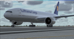
This FSX repaint represents the third Boeing 777-200LRF freighter for Lufthansa Cargo currently undergoing final flight tests and scheduled to be delivered at the end of Feb 2014.
The aircraft was hand painted using the PMDG paint kit, features DDS DXT5 textures and includes the following custom features:- realistic placement of fuselage decals as per real-world aircraft, a fully weathered appearance and additional dirt layers applied to the fuselage and wings, registration and SelCal placards applied to the virtual cockpit and customized cargo containers for Lufthansa Cargo operations and airline livery options config file.
PMDG 777-200LR/F base package for FSX required. Easy installation via PMDG Operations Center. See readme for important installation instructions and enjoy the repaint.
| Filename: | Lufthansa_Cargo_Ni_Hao_China_Boeing_777200LRF_DALF.zip |
| License: | Freeware |
| Added: | 15th February 2014, 18:51:29 |
| Downloads: | 370 |
| Author: | Mark Aldridge |
| Size: | 10.1 MB |
| Category: Flight Simulator X - Sounds | |
| CTAF Voicepack Mod |
|
File Description:
This voicepack mod introduces a number of changes to the way CTAF communications are handled in the sim. For all CTAF communications, aircraft now repeat the name of the airport at the end of the transmission to help ensure copy of the airport name during busy CTAF activity. Furthermore aircraft now say on all transmissions the type of aircraft they are (Beech, Cessna, Mooney, etc). Finally, the default format of position announcements for VFR/IFR aircraft would say "10 miles west of Miller County", which is an overly-repetitive use of the airport name. Aircraft now announce position/bearing without saying the airport name, as that is repeated at the end of the transmission. This is all meant to better reflect real-world CTAF transmission protocols.
| Filename: | CTAF_Voicepack_Mod.zip |
| License: | Freeware |
| Added: | 30th October 2013, 17:22:17 |
| Downloads: | 557 |
| Author: | Drew Sikora |
| Size: | 24.6 KB |


© 2001-2026 AVSIM Online
All Rights Reserved
Privacy Policy |