
Where Flight Simulation Enthusiasts Gather from Around the World!
AVSIM Library - Search Results

| Category: Navigation and ATC - Navigation | |
| Whitehorse Sectional Chart Chunks Optimized For Moving Map Application |

|
File Description:
Sectional chart chunks made from the August 2009 Sectional charts at the original scale, formatted in the WGS84 lat/lon geographic coordinate system for GPS, moving map application for flight simulation use.
These chart chunks were converted to the JPEG format for compatibility and size. Coverage is the full Sectional area North and South divided into JPEG tiles. They are about 3k x 3k pixels at 2.5mb with coverage of 90nm x 130nm per tile. Included is also the projection files and world files.
Note: This type of map is a equal grid and no further calibration is needed, only the two points referenced in the world file. Example: for users of FSM Moving Map, just mass import, done.
| Filename: | Whitehorse_Sectional_Chart_Chunks_Optimized_For_Mo.zip |
| License: | Freeware |
| Added: | 28th February 2010, 06:29:44 |
| Downloads: | 145 |
| Author: | David Myers |
| Size: | 16.1 MB |
| Category: Navigation and ATC - Navigation | |
| Western Aleutian Islands Sectional Chart Chunks Optimized For Moving Map Application |
|
File Description:
Sectional chart chunks made from the August 2009 Sectional charts at the original scale, formatted in the WGS84 lat/lon geographic coordinate system for GPS, moving map application for flight simulation use.
These chart chunks were converted to the JPEG format for compatibility and size. Coverage is the full Sectional area North and South divided into JPEG tiles. They are about 3k x 3k pixels at 2.5mb with coverage of 90nm x 130nm per tile. Included is also the projection files and world files.
Note: This type of map is a equal grid and no further calibration is needed, only the two points referenced in the world file. Example: for users of FSM Moving Map, just mass import, done.
| Filename: | Western_Aleutian_Islands_Sectional_Chart_Chunks_Op.zip |
| License: | Freeware |
| Added: | 28th February 2010, 06:32:04 |
| Downloads: | 166 |
| Author: | David Myers |
| Size: | 7.82 MB |
| Category: Navigation and ATC - Navigation | |
| Point Barrow Sectional Chart Chunks Optimized For Moving Map Application |
|
File Description:
Sectional chart chunks made from the August 2009 Sectional charts at the original scale, formatted in the WGS84 lat/lon geographic coordinate system for GPS, moving map application for flight simulation use.
These chart chunks were converted to the JPEG format for compatibility and size. Coverage is the full Sectional area North and South divided into JPEG tiles. They are about 3k x 3k pixels at 2.5mb with coverage of 90nm x 130nm per tile. Included is also the projection files and world files.
Note: This type of map is a equal grid and no further calibration is needed, only the two points referenced in the world file. Example: for users of FSM Moving Map, just mass import, done.
| Filename: | Point_Barrow_Sectional_Chart_Chunks_Optimized_For_.zip |
| License: | Freeware |
| Added: | 28th February 2010, 06:32:41 |
| Downloads: | 158 |
| Author: | David Myers |
| Size: | 18.64 MB |
| Category: Navigation and ATC - Navigation | |
| Nome Sectional Chart Chunks Optimized For Moving Map Application |
|
File Description:
Sectional chart chunks made from the August 2009 Sectional charts at the original scale, formatted in the WGS84 lat/lon geographic coordinate system for GPS, moving map application for flight simulation use.
These chart chunks were converted to the JPEG format for compatibility and size. Coverage is the full Sectional area North and South divided into JPEG tiles. They are about 3k x 3k pixels at 2.5mb with coverage of 90nm x 130nm per tile. Included is also the projection files and world files.
Note: This type of map is a equal grid and no further calibration is needed, only the two points referenced in the world file. Example: for users of FSM Moving Map, just mass import, done.
| Filename: | Nome_Sectional_Chart_Chunks_Optimized_For_Moving_M.zip |
| License: | Freeware |
| Added: | 28th February 2010, 06:39:38 |
| Downloads: | 184 |
| Author: | David Myers |
| Size: | 16.46 MB |
| Category: Navigation and ATC - Navigation | |
| McGrath Sectional Chart Chunks Optimized For Moving Map Application |
|
File Description:
Sectional chart chunks made from the August 2009 Sectional charts at the original scale, formatted in the WGS84 lat/lon geographic coordinate system for GPS, moving map application for flight simulation use.
These chart chunks were converted to the JPEG format for compatibility and size. Coverage is the full Sectional area North and South divided into JPEG tiles. They are about 3k x 3k pixels at 2.5mb with coverage of 90nm x 130nm per tile. Included is also the projection files and world files.
Note: This type of map is a equal grid and no further calibration is needed, only the two points referenced in the world file. Example: for users of FSM Moving Map, just mass import, done.
| Filename: | McGrath_Sectional_Chart_Chunks_Optimized_For_Movin.zip |
| License: | Freeware |
| Added: | 28th February 2010, 14:08:28 |
| Downloads: | 148 |
| Author: | David Myers |
| Size: | 15.39 MB |
| Category: Flight Simulator 2004 - Scenery | |
| Real Night Water |
|
File Description:
In the real world, at night, water appears all black. You can't see it from the air unless there is a reflection from the moon.
To get this effect in fs2004, all water display effects have to be set to minimums, but then you lose all reflections. Not any more! Now with Real Night Water,
you no longer have to mess with your diplay settings. The water appears black and there is even waves and moon reflections, just like
in the real world. No more silver glaze over the water at night. It will work with default textures but was designed utilizing
Extra Water by FullThrottleSims/Hector Davila (extrawater.zip) which is highly recommended and freeware available on this site.
| Filename: | Real_Night_Water.zip |
| License: | Freeware |
| Added: | 26th July 2006, 02:34:10 |
| Downloads: | 7,009 |
| Author: | Dan Fleming |
| Size: | 7.85 KB |
| Category: Flight Simulator 2004 - Aircraft Repaints, Textures and Modifications | |
| PIA Boeing 737-900 F1 Special |
|
File Description:
Pakistan International Airlines PIA / KLM Boeing 737-900 PH-BXP utilizing the Project Opensky 737-900 model. It is depicted here wearing a special 'F1 tour' livery, designed by Virtual PIA. This special livery is designed to celebrate the start of Virtual PIA's F1 tour, which will follow the F1 world championship around the world. The aircraft is leased to VPIA from KLM, and therefore wears the Dutch registration, as well as the Dutch and EU flags in addition to the Pakistan flag. Visit www.vpia.org for more. With working stair texture. Complete pack, requires no external downloads. Textures in DXT3 format to avoid blurring. Repaint by Ahmed Ahsen & Irfan Khan, an exclusive production from Virtual PIA.
| Filename: | PIA_Boeing_737900_F1_Special.zip |
| License: | Freeware, limited distribution |
| Added: | 4th March 2010, 22:48:12 |
| Downloads: | 197 |
| Author: | Ahmed Ahsen / Irfan Khan(Virtual PIA/WWW.VPIA.ORG) |
| Size: | 7.23 MB |
| Category: Flight Simulator 2004 - Miscellaneous Files | |
| LDS767 Long Haul Tutorial |
|
File Description:
Level-D Simulations VERSION 2 of the 767-300ER "Golden Argosy" Long Haul Tutorial. Climb aboard the "Golden Argosy" for an eight hour journey from New York’s Kennedy airport to Roma’s Fiumicino airport aboard the Level-D 767-300ER with B767 Captain, Tony Vallillo. Mr. Vallillo penned the 6 part series of “Golden Argosy” articles that were published at FlightSim.com in 2004. This 40+ page tutorial is written in a step-by-step format based on LDS767’s Expanded Checklist. Captain Vallillo's real world "Golden Argosy" flight is interspersed throughout, offering real world perspective for the flight simmer. The tutorial includes charts and flight plans and is intended to assist the novice and intermediate LDS767 pilot.
| Filename: | LDS767_Long_Haul_Tutorial.zip |
| License: | Freeware |
| Added: | 3rd June 2005, 01:35:46 |
| Downloads: | 14,053 |
| Author: | Daryl Shuttleworth, LDS767 Beta Team |
| Size: | 7.84 MB |
| Category: Flight Simulator 2004 - Original Aircraft | |
| C.R.D.A. Cant.Z.1007bis 'Alcione' |
|
Images related to this file:
File Description:
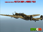
The CANT Z.1007bis Alcione (Kingfisher) was a three-engined medium bomber,with wooden structure.Designed by ingegner Filippo Zappata,who also designed the CANT Z.506 hydroplane.It had excellent flying characteristics and good stability and was regarded by some as "the best Italian bomber of World War II" although its wooden structure was easily damaged by the climate,like those experienced in North Africa and in Russia.It was used by the Italian Regia Aeronautica,Italian Co-Belligerent Air Force,Aeronautica Nazionale Repubblicana and Luftwaffe during World War II.
VC only.GMax Models and Skins by Milton Shupe & Manuele Villa, Flight dynamics by FSAviator,It also works (Tested) subject to some limitations within in FSX. By Manuele Villa/MVG3D, May 2014.
| Filename: | CRDA_CantZ1007bis_Alcione.zip |
| License: | Freeware |
| Added: | 6th May 2014, 09:02:06 |
| Downloads: | 614 |
| Author: | Manuele Villa & Milton Shupe |
| Size: | 49.45 MB |
| Category: Flight Simulator 2004 - Aircraft Repaints, Textures and Modifications | |
| TWA Boeing 767-300 |
|
Images related to this file:
File Description:

Trans World Airlines (TWA) was a major American airline from 1924 until 2001. In 2001, TWA filed for a third and final bankruptcy and was acquired by American Airlines
This is fiction 'Heritage Jet' with small American Airlines titles found near the front doors.
You need the payware LevelD 767 for this repaint to work. Please read the instructions carefully or this Level D for FS2004 repaint will not show up properly.
| Filename: | TWA_Boeing_767300.zip |
| License: | Freeware |
| Added: | 8th March 2018, 00:33:35 |
| Downloads: | 159 |
| Author: | Gary Claridge-king |
| Size: | 7.48 MB |


© 2001-2026 AVSIM Online
All Rights Reserved
Privacy Policy |