
Where Flight Simulation Enthusiasts Gather from Around the World!
AVSIM Library - Search Results

| Category: Flight Simulator 2004 - AI Aircraft | |
| Boeing B-52 Stratofortress (Part 9) |

|
Images related to this file:
File Description:

Boeing B-52 Stratofortress (Part 9). The B-52 first flew in 1952, the last one was built in 1961, and there are still over 90 of the original 744 airframes either in front-line service or in a ready-reserve status. With extensive avionics upgrades starting this year, the USAF plans on using the B-52s until 2045, 93 years after first flight. The aircraft has an impressive resume, having served in five shooting wars and was the backbone of Strategic Air Command's nuclear deterrent air component during almost forty years of Cold War service.
Jake Burrus started this AI traffic model a couple of years ago, and I was honored to pick up the project and get it across the finish line, with no small amount of help from Mike MacIntyre, as usual. This is a 7-LOD AI traffic model representing the Stratofortress in all of its operational service. This is part 9, showcasing the B-52G used from 1987 to the end of 1991, excluding the Gulf War; with a total of 28 repaints. Also included are optional models for VFR traffic use. Aircraft model by Jake Burrus and Mike Pearson, master textures and repaints by Mike Pearson, flight dynamics by Mike MacIntyre. Please read the extensive documentation contained in the file.
| Filename: | Boeing_B52_Stratofortress_Part_9.zip |
| License: | Freeware |
| Added: | 27th October 2013, 00:19:11 |
| Downloads: | 695 |
| Author: | Michael Pearson |
| Size: | 13.9 MB |
| Category: Flight Simulator 2004 - AI Aircraft | |
| Boeing B-52 Stratofortress (Part 10) |
|
Images related to this file:
File Description:

Boeing B-52 Stratofortress (Part 10). The B-52 first flew in 1952, the last one was built in 1961, and there are still over 90 of the original 744 airframes either in front-line service or in a ready-reserve status. With extensive avionics upgrades starting this year, the USAF plans on using the B-52s until 2045, 93 years after first flight. The aircraft has an impressive resume, having served in five shooting wars and was the backbone of Strategic Air Command's nuclear deterrent air component during almost forty years of Cold War service.
Jake Burrus started this AI traffic model a couple of years ago, and I was honored to pick up the project and get it across the finish line, with no small amount of help from Mike MacIntyre, as usual. This is a 7-LOD AI traffic model representing the Stratofortress in all of its operational service. This is part 10, showcasing the B-52G used from 1991 to the end of B-52G service in 1994; with a total of 18 repaints. Also included are optional models for VFR traffic use. Aircraft model by Jake Burrus and Mike Pearson, master textures and repaints by Mike Pearson, flight dynamics by Mike MacIntyre. Please read the extensive documentation contained in the file.
| Filename: | Boeing_B52_Stratofortress_Part_10.zip |
| License: | Freeware |
| Added: | 27th October 2013, 00:19:14 |
| Downloads: | 700 |
| Author: | Michael Pearson |
| Size: | 9.96 MB |
| Category: Flight Simulator 2004 - AI Aircraft | |
| Boeing B-52 Stratofortress (Part 1) |
|
Images related to this file:
File Description:

Boeing B-52 Stratofortress (Part 1). The B-52 first flew in 1952, the last one was built in 1963, and there are still over 90 of the original 744 airframes either in service or in a ready-reserve status. With extensive avionics upgrades starting this year, the USAF plans on using the B-52s until 2045. The aircraft has an impressive resume, having served in five shooting wars and was the backbone of Strategic Air Command's nuclear deterrent air component during almost forty years of Cold War service.
Jake Burrus started this AI traffic model a couple of years ago, and I was honoured to pick up the project and get it across the finish line, with no small amount of help from Mike MacIntyre, as usual. This is a 7-LOD AI traffic model representing the Stratofortress in all of its operational service. This is part 1, covering all operational models which only did nuclear deterrence, not actual combat use. This file includes the B-52B, B-52C, B-52E, and RB-52B models, with a total of 68 repaints across all variants. Also included are optional models for VFR traffic use. Aircraft model by Jake Burrus and Mike Pearson, master textures and repaints by Mike Pearson, flight dynamics by Mike MacIntyre. Please read the extensive documentation contained in the file.
| Filename: | Boeing_B52_Stratofortress_Part_1.zip |
| License: | Freeware |
| Added: | 24th September 2013, 22:09:56 |
| Downloads: | 1,470 |
| Author: | Michael Pearson |
| Size: | 35.75 MB |
| Category: Flight Simulator X - Utilities | |
| HUD Parameters for FSX |
|
Images related to this file:
File Description:
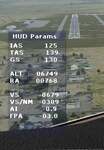
HUD_Parameters.lua is a Lua script that displays flight parameters in a small text window that pops up when the script is selected by an assigned key or button if the aircraft is in the air.
Parameters displayed are:
• Indicated Airspeed (IAS. Kts)
• True Airspeed (TAS, Kts)
• Ground Speed (GS, Kts)
• Mach# (when above a user settable altitude, currently 25000ft)
• Altitude (ALT, ft)
• Radio Altitude (RA, ft)
• Vertical Speed (VS, ft/min)
• Vertical Speed per Nautical Mile (VS/NM, ft/NM)
• Attitude Indicator pitch (AI, degrees)
• Flight Path Angle (FPA, degrees)
The top of the script contains user settable values for the size and location of the display, the altitude above which the a/c Mach# will be displayed (default is 25000ft), the data update interval in milliseconds (default is 2000),
and whether or not data is to be logged in HUD_Parameters.log (default is 0, off). These values can be set using a text editor like NotePad.
A registered copy of FSUIPC is required to execute the Lua script. Simply copy the script to the Modules folder of FSX and use FSUIPC4 to assign a key, button or switch to toggle the script on and off.
The script turns off if the aircraft is on the ground.
Al Klayton
| Filename: | HUD_Parameters_for_FSX.zip |
| License: | Freeware |
| Added: | 29th July 2017, 07:15:25 |
| Downloads: | 473 |
| Author: | Al Klayton |
| Size: | 16.82 KB |
| Category: Flight Simulator 2004 - AFCAD Files | |
| Southwestern British Columbia Airport Corrections |
|
File Description:
As shorelines, water bodies, roads, railways and other features become more accurate in addon scenery, inaccuracies in airport placement become apparent. Although Microsoft did an excellent job of using published data to place airports, the published information is not always accurate. Some airports in the area of interest were misplaced by as much as 850m, thus conflicting with water and/or roadways. This release corrects Canadian airports in South-western British Columbia, in LOD5 cell 15x14 (915140). This area covers a portion of Vancouver Island from Duncan to Victoria, and the BC Mainland as far east as Douglas Lake and north of Pemberton. In this region CAK3, CAL3, CBT6, CYHE, CYLY, and CYPS are corrected, and Bruce Ellison has kindly modified his CAM3 for inclusion; see separate readme document for details. All these airports have been activated for AI use. A few buildings that may conflict from roads have been removed from CYNJ. The unrealistically large flatten and airport polygon at CYYJ is reduced in size. Airport features that end up in the water have been removed from CYVR and the overly large flatten there reduced. Some Rwy12 goodies have been tossed in as well, but if these are not important to the user, it is not necessary to have Rwy12 installed. Ultimate Terrain or similar accurate hydrology and roads recommended. FSGenesis 38m mesh or other high quality terrain mesh recommended.
| Filename: | Southwestern_British_Columbia_Airport_Corrections.zip |
| License: | Check within download |
| Added: | 30th May 2005, 07:31:45 |
| Downloads: | 3,002 |
| Author: | Jon Patch, Bruce Ellison |
| Size: | 1.53 MB |
| Category: Flight Simulator 2004 - Utilities | |
| Destination Finder for FS9 v1.1 |
|
File Description:
In this program, you enter the ICAO code of your start airport, the distance you wish to fly, and the heading on which you wish to fly. The program will search through all the stock airports in FS9, and will compile a list of airports nearest to your desired destination. For extra flexibility, you can also leave the heading and/or the distance unspecified. Alternatively, the program can now read your aircraft’s position in all versions of FS, and use that as the starting point of the search. You can optionally specify a maximum and/or minimum length for the runway, whether the runway must have an ILS, a maximum elevation for the destination airport, the runway surface (hard or soft or water) and whether the airport should be civil or military or either. The program can be useful for planning your own flight or for drawing up AI flightplans. It is a standalone program, and uses FS9 airport and runway data, but, with that limitation in mind, it can equally be used with other versions of FS. Version 1.1 has a much improved formula for calculating longitude and latitude over longer distances, and is now very accurate over all distances. Version 1.1 also incorporates a number of new features suggested by user feedback. The upgrade is recommended for all users. Needs the .NET Framework 2.0.
| Filename: | Destination_Finder_for_FS9_v11.zip |
| License: | Freeware |
| Added: | 24th January 2008, 00:17:07 |
| Downloads: | 4,878 |
| Author: | Martin Gleeson |
| Size: | 1.69 MB |
| Category: Flight Simulator X - AFCAD Files | |
| KOPF - Opa Locka - Miami, Florida 2013 |
|
File Description:
Opa-locka Airport (IATA: OPF, ICAO: KOPF, FAA LID: OPF), also known as Opa-locka Executive Airport, is a general aviation airport and joint civil-military airfield 10 miles (16 km) north of Downtown Miami, primarily in metropolitan
Miami, Florida, United States, with a portion within the city proper of Opa-locka.
The airport's control tower is manned from 7:00 AM to 9:00 PM. The airport has four fixed base operators. It is owned by Miami-Dade County and operated by the Miami-Dade Aviation Department.
The tenant military activity is Coast Guard Air Station Miami, operating HU-25 Guardian jet aircraft, the HC-144 Ocean Sentry[4] turboprop aircraft and HH-65 Dolphin helicopters for coastal patrol and air-sea rescue operations.
Much of CGAS Miami's facilities were originally built during World War II as part of the former Naval Air Station Miami.
DayJet previously provided an on-demand jet air taxi service from this airport to 44 airports in 5 states. The company filed for Chapter 7 bankruptcy liquidation in 2008.
The airport is currently served by several cargo and charter airlines who use the U.S. customs facility. Maintenance and modification of airliners up to Boeing 747 size are carried out by several aviation firms
This file has the right coordenates, apron and characteristics of the airport, airport vehicles and buildings, Airport charts included.
| Filename: | KOPF__Opa_Locka__Miami_Florida_2013.zip |
| License: | Freeware |
| Added: | 6th January 2013, 11:39:28 |
| Downloads: | 770 |
| Author: | anwar gonzalez |
| Size: | 3.96 MB |
| Category: Flight Simulator 2004 - Scenery | |
| Terrace CYXT Updated |
|
Images related to this file:
File Description:
This revises the previous versions by adding two missing buildings, corrects the apron markings and parking and adds a third gate, creates more GA parking, updates the AI to include, for instance, a Westjet flight, and most importantly of all adds the ILS to runway 33. It is complete in itself and can be installed as-is without first installing previous versions. Terrace is fifteen miles east and inland from Prince Rupert, which is 500 miles north of Vancouver up the BC coast. It is at the point in the mountains where two fjords meet, one coming from Prince Rupert and the other from Kitimat. The population of the town is around 12,500. The airport is called Terrace-Kitimat and is a couple of miles south of the town of Terrace, on the south side of the Skeena River. There are two runways, and the main one is a recently-extended 7,500 feet long and lit 33-15 with approach lighting to both ends and an ILS on 33. The second is 5,373 feet of unlit 03-21. The apron has been enlarged to be able to accommodate a Boeing 737, though there is at the moment no airline using a 737 for flights to Terrace. The pics and the video show the surrounding hilly terrain and the nearby river between the airport and the town.
| Filename: | Terrace_CYXT_Updated.zip |
| License: | Freeware, limited distribution |
| Added: | 13th January 2019, 18:38:12 |
| Downloads: | 177 |
| Author: | Roger Wensley |
| Size: | 15.64 MB |
| Category: Flight Simulator 2004 - Scenery | |
| Peace River CYPE in northwest Alberta, Canada UPDATED |
|
Images related to this file:
File Description:
This is an updated version of the original post (from 2014) made in November 2018. It provides missing textures, and deals properly with an ai problem that I thought I had already fixed. It also adds extra objects to the apron area and adds a third gate. It is complete in itself and can be installed as-is if you do not have the original post. The Peace River flows east from the Rockies, joining up with the Slave River to empty into Great Slave Lake. The town is on both banks close to a bend where the Peace turns to the north, 245 miles northwest of Edmonton. The population is 7,000 and the surrounding area is either farmland or forest. The airport is just over 3 miles west of the town. The runway is 5,000 feet of wide asphalt (150 feet) aligned 04/22, lit, and with PAPI. There is a second runway to the south of the main runway, 1,900 feet of grass and aligned 08/26. The apron is to the north of the runway at the eastern end and is large; there is a purpose-built terminal building, plus other hangar buildings along taxiway C that extends westward from the apron. The airport is experiencing an increase in scheduled and GA flights in the last few years.
| Filename: | Peace_River_CYPE_in_northwest_Alberta_Canada_UPDAT.zip |
| License: | Freeware, limited distribution |
| Added: | 10th December 2018, 17:33:25 |
| Downloads: | 128 |
| Author: | Roger Wensley |
| Size: | 24.27 MB |
| Category: Flight Simulator 2004 - Scenery Design | |
| Parking SS FS9 scenery objects and textures |
|
File Description:
This collection of objects and textures gives you three different ways to easily create parking lot areas in FS9: * Photoreal parking textures. Great for quickly creating large parking areas that look very realistic from above, but not so good from ground level. These textures can be used in two different ways:
1. FS9 scenery library objects. These are large square or rectangular objects that can be placed using Instant Scenery, EZ-Scenery and similar programs. These will give the most realistic appearance.
2. AFCAD textures. By replacing some of the FS9 taxiway/apron textures with these textures, you can easily create parking areas using AFCAD. Because of the way FS9 uses these textures, the results are not as realistic as with the scenery library objects. The main advantage of using AFCAD is that you can create parking areas of any irregular shape.
* Ground marking and divider scenery library objects. These will give you parking areas that look the most detailed and realistic at ground level. Looks great combined with vehicle objects. PLEASE NOTE: The ground markings have some height to them that is very noticeable up close. I made them this way so they will not appear to "shimmer" in FS9. For best appearance, sink them into the ground a bit when placing them in FS9. I find that -.015 meters works well.
| Filename: | Parking_SS_FS9_scenery_objects_and_textures.zip |
| License: | Freeware |
| Added: | 24th February 2008, 22:33:14 |
| Downloads: | 6,686 |
| Author: | Sidney Schwartz |
| Size: | 1.14 MB |


© 2001-2026 AVSIM Online
All Rights Reserved
Privacy Policy |