
Where Flight Simulation Enthusiasts Gather from Around the World!
AVSIM Library - Search Results

| Category: Flight Simulator 2004 - Miscellaneous Files | |
| Project Opensky Boeing 777 Series FDE Service Pack D |

|
File Description:
This package may NOT BE ALTERED, MERGED, REEDITED, REDISTRIBUTED OR UPLOADED AS PART OF ANY PAYWARE OR FREEWARE PACKAGE. LEGAL IMPLICATIONS EXIST! This revised 777 package inclues: - Correct 777 performance and feel based on airline FAA Level D simulators and documentation. - Use of MSFS payload and fuel editor. - Use of MSFS flight planner and Navigation Log for flight/fuel planning. - Use of true 777 landing gear footprint as default gear points. Standard 3-wheel points have been included as an additional option [courtesy of Philip Foglar, POSKY] in this update along with more new variants of 777-200ER [PW4098, GE90-90B]. Engine start-up time has been modified again for more realistic timing [YouTube Video was used as a reference]. Also included are the FDEs for the recently released 777-300 series. AES Compatability files included. The FDEs included for this series are copyrighted by Project Opensky, Brandon D. Henry, and Warren C. Daniel. They may not be merged, altered and/or used for other uploads to any other aircraft [or website] without Authors' permission.
| Filename: | Project_Opensky_Boeing_777_Series_FDE_Service_Pack.zip |
| License: | Freeware, limited distribution |
| Added: | 30th December 2008, 18:06:51 |
| Downloads: | 4,007 |
| Author: | Brandon D. Henry |
| Size: | 246.66 KB |
| Category: Flight Simulator X - Aircraft Repaints, Textures and Modifications | |
| Myanmar Airways ATR72-200 |
|
File Description:
ISDT ATR72-200 repaint by Phyo Pyae Sone
Myanmar Airways, the state owned national carrier was formed in the year 1948, with the name of " Union Of Burma Airways".
The domestic schedule flights were commenced in 1948, with (9) seater (6) De Havilland Dove aircrafts and was initially flying to 19 stations.
The external schedule flights were operated to Bangkok, Calcutta and Chittagong in 1950.
The airline was reformed as a board under the union of Burma Airways Acts of 1952, according to the international schedule flight extension program.
The flights were operated to Singapore, Kathmandu and later to Bangkok, Calcutta, Dhaka, Hongkong and Jakarta until 15 August 1993.
In 1989 it was renamed Myanma Airways(MA) with the new image logo. Three pillars of MA are Safety, Service and Image. Currently the daily domestic schedule flights are operating to (21) destinations.
Up to date,Myanma Airways has 3 Fokker F28s(replacing with ERJ190 in 2012/13),2 ATR72-200s,1 ATR42-300,3 MA60s and 2 Beechcraft 1900Ds.
Please view readme file for installation
| Filename: | Myanmar_Airways_ATR72200.zip |
| License: | Freeware |
| Added: | 14th December 2012, 09:42:25 |
| Downloads: | 130 |
| Author: | Phyo Pyae Sone |
| Size: | 4.67 MB |
| Category: Flight Simulator 2002 - AFCAD Files | |
| China Lake NAWS, CA. AFCAD JANET |
|
File Description:
This is the AFCAD to a top secret facility known as China Lake Naval Air weapons station in California. The stories are wide and far ranging about this secret place in the desert.
There is a supposed underground tram system running 180 MPH under the Death Valley mountains to Area 51. (some reports of the tram running up to 275 MPH) Lockheed has a targeting and ranging station on base used to develop aircraft that are invisible. (the craft blend with the sky) Orbs can be seen here, UFO's reported daily, and on and on.
Folklore,? maybe. I dont know anything. Speculation only. Gates are approximated. My work is free to the simming community. Please do not sell any of ol' Bucks work.
Please do not include my work any any pay packages. Free is good. God bless the USA. If this is subversive to the USA, please feel free to pull my AFCADS.
P.S.: SDK is included with Lee Swordys installer. I had trouble getting this AFCAD to install so good luck. That is why I have included the SDK.
| Filename: | China_Lake_NAWS_CA_AFCAD_JANET.zip |
| License: | Freeware, limited distribution |
| Added: | 6th September 2003, 17:06:33 |
| Downloads: | 471 |
| Author: | Buck Martin |
| Size: | 49.75 KB |
| Category: Flight Simulator 2004 - AI Flight Plans | |
| Ryanair Summer 2012 |
|
Images related to this file:
File Description:
A comprehensive collation of schedules for the Summer 2012 season. 100% of flights are included, utilising the ENTIRE Ryanair fleet of 295 aircraft, of which at the time of this release, a couple are still to be delivered in the coming weeks. The schedules compiled here are 'as they stand at the moment' for the last week of July, when the season is at its peak. As is the norm for Ryanair, the start of the new season of schedules means that there are tons of new routes, destinations, and bases. New bases are: Billund, Budapest, Karlsruhe, Palma Mallorca, Paphos, and Wroclaw. New destinations include: Berlin-Brandenburg (Schonefeld closing soon), Cologne, Turku, Warsaw-Modlin, Paphos, Asturias, Bilbao, Mahon-Menorca, Dole, Alexandropoulis, Kefallonia, Araxos, of which, all are included in these schedules. Each base has the correct number of alloted aircraft, although there are a small handful of aircraft which move from base to base during the course of the week, to tie up the very few loose end flights which occurred after compiling. (These also include some positioning flights to make this possible).
| Filename: | Ryanair_Summer_2012.zip |
| License: | Freeware |
| Added: | 12th March 2012, 04:47:31 |
| Downloads: | 1,561 |
| Author: | Chris Horsfield |
| Size: | 98.62 KB |
| Category: Navigation and ATC - Navigation | |
| LSZS - Samedan visual approach chart v3 |
|
Images related to this file:
File Description:
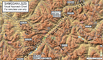
Custom made visual approach chart and pilot's briefing for Engadin (St. Moritz) Samedan LSZS airport in Switzerland, Europe's highest elevation airport (5,600 ft.) situated in the Swiss Alps. This airport is a day VFR operations only and has no instrument approach due to extreme terrain around it. A demanding visual descent into a canyon, in between steep rising terrain, is required to make the visual approaches for both runways with a steep 4.4* degrees final approach portion guided by the PAPI's. Still, executive jets up to Boeing 737(BBJ) size approach the airport often in the winter peak season VFR with these procedures. It is designed as per real operators' pilot briefing for Samedan. Real airport's full pilot briefing document also included. The real airport's excellent briefing (included) intentionally does not contain the maneuvers needed for the approach of jets through the mountains but only reporting points for all and maneuvers for light aircraft only. This gap is what this chart covers. Version 2 chart included better graphics and refined visual procedure for jets and version 3 now includes real pilot's briefing guide.
| Filename: | LSZS__Samedan_visual_approach_chart_v3.zip |
| License: | Freeware, limited distribution |
| Added: | 20th March 2015, 23:35:11 |
| Downloads: | 2,026 |
| Author: | Kyprianos Biris |
| Size: | 7.1 MB |
| Category: Flight Simulator X - Scenery | |
| Mid West Victoria UPDATED. 14 airports. YARA YSWL YMBU YSTA YDOD YWYF YBIR YHPN YKER YSLK YSWH + *NEW* YNHL YHML YWKB |
|
Images related to this file:
File Description:
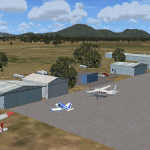
This is an updated version (original Jan 2018). Fixed some ground texture problems plus a lot of added and improved objects and 3 NEW airports. There are 14 airports starting at Ararat and extending up to the Murray at Swan Hill. YARA Ararat YSWL Stawell YMBU Maryborough YSTA Saint Arnaud YDOD Donald YWYF Wycheproof YBIR Birchip YHPN Hopetoun YKER Kerang YSLK Sealake YSWH Swanhill + *NEW* YNHL Nhill YHML Hamilton YWKB Warracknabeal. A lot of airports but not a quicky slap dash effort. It is several hundred hours over many months. Surrounding scenery modified to match real life. Towns, race courses, forests, sewage treatment ponds, obstacles (towers etc) have been added. Included is an AI traffic file that covers all airports that don't already have AI. These files are for Flight Simulator X. Made using Airport Design Editor using some objects borrowed from Robert Budd's excellent Baccus Marsh. RECOMMENDED The scenery is designed to interface with ORBX FTX_AU scenery for Australia (payware). It will work without ORBX but will not interface as well with standard scenery.
| Filename: | Mid_West_Victoria_UPDATED_14_airports_YARA__YSWL__.zip |
| License: | Freeware |
| Added: | 16th May 2019, 18:19:35 |
| Downloads: | 418 |
| Author: | Colin Jeffery |
| Size: | 5.23 MB |
| Category: Flight Simulator 2004 - AI Aircraft | |
| RAF Leeming 1990 - Tornado F3s |
|
Images related to this file:
File Description:
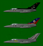
This is the last of the three bases that I have covered with the Tornado F3. RAF leeming was the second base to receive the F3 after RAF Coningsby, with the formation of No. 11 Sqn in July 1988.
No. 23 Sqn followed in the November and No. 25 Sqn was the last in February of 1989.
These paints represent the aircraft as they were in 1990. I have included the 11 Sqn boss bird of David Hamilton, 11 Sqn's first Commanding Officer on the F3, and the two 75th Anniversary aircraft of 23 & 25 Sqns. They are all DXT3 and mipped, with customized alpha channels to represent different payloads.
There are flightplans included, but these are what I would call station-heavy, none of the aircraft stay away overnight and all need spots. How you resolve this is up to you but I won't be providing any other plans for these......just yet......
You will need to download or have in your system, the Panavia Tornado F3 by Fernando Martinez (ai_tornado.zip)
| Filename: | RAF_Leeming_1990__Tornado_F3s.zip |
| License: | Freeware, limited distribution |
| Added: | 1st February 2013, 21:05:25 |
| Downloads: | 429 |
| Author: | Daryl Payne, Fernando Martinez |
| Size: | 8.39 MB |
| Category: Flight Simulator X - Missions | |
| White Castle Run Mission For FSX Fixed |
|
File Description:
I apologize for the problems experienced with my original release of this mission. I have made the necessary changes and have had it tested indepenently. In the meantime, the people of the Quad City area of Iowa and Illinois have grown even hungrier for some real White Castle burgers. Not those frozen things you buy at the supermarket, but the real thing, hot and fresh off the grill. The only problem is, the closest White Castle restaurant is in the Chicago area. Your assignment is to fly the Mooney Bravo from the Davenport IA Municipal Airport to the Aurora IL Municipal Airport, pick up 250 White Castle burgers which will be waiting for you there, then turn right around and fly them back to Davenport. This mission should take approximately 1Hr 30 Minutes to 1Hr 45Minutes to complete. Ther will also be a brief guided tour of the Quad City area, and the mission will also take a little twist. There is also a reward for completing the mission successfully.
| Filename: | White_Castle_Run_Mission_For_FSX_Fixed.zip |
| License: | Freeware |
| Added: | 2nd December 2007, 00:56:26 |
| Downloads: | 2,416 |
| Author: | Patrick Finch |
| Size: | 7.13 MB |
| Category: Flight Simulator 2004 - Scenery | |
| Zion National Park South, Hurricane (1L8), Colorado City (KAZC), Utah/Arizona, Photo-Scenery (FS9 & FSX) |
|
Images related to this file:
File Description:
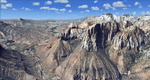
Covers the southern part of Zion National Park extends south along the cities of Hurricane and Colorado City. Zion National Park is another place where erosion of the Colorado Plateau formed the most beautiful colorful stone formations of unique and wonderful shapes. There are nine different layers of stone visible in the park. Most of them consist of sandstone. But there is also limestone, gypsum, siltstone, shale, clay and mudstone. The Virgin River cut a spectacular and famous canyon thru Zion Park that is as narrow as 20ft and up to 2000ft tall.
High resolution versions of this scenery for FS9 and FSX (much sharper, but larger and multiple downloads)
are available at www.blueskyscenery.com/CNY_South3West5.html . The screenies are taken from the high-res versions,
so expect this version to be slightly more blurry. Thanks to Joop Mak for providing custom AFCADs that
correct airport layouts so that they align with the photo-textures! They are available at www.blueskyscenery.com/AFCADs.html . YourDonation@Work: Dedicated to Jerry, Ralph J. and Lance.
| Filename: | Zion_National_Park_South_Hurricane_1L8_Colorado_Ci.zip |
| License: | Freeware, limited distribution |
| Added: | 20th March 2010, 23:26:42 |
| Downloads: | 1,784 |
| Author: | Gottfried Razek - blueskyscenery.com |
| Size: | 95.39 MB |
| Category: Flight Simulator 2004 - Scenery | |
| Baker Lake CYBK in Nunavut, Canada |
|
Images related to this file:
File Description:
Baker Lake is the only Nunavut community that is not next to the sea. It is, as you might have guessed, on the shore of Baker Lake and 160 miles west and a bit north of Rankin Inlet on the shore of Hudson Bay (a recent post by Sid and Pete). The Hudson Bay Company opened a trading post there in 1916 and the town slowly developed, though as recently as 1946 the population was still only 32. These days the airfield is the support field for several nearby mines and there are now nearly 1,800 folks in Baker Lake using the stores, schools, churches, hospital, etc. The runway is almost 4,200' of 100' wide gravel and lighted; the alignment is 162T and 342T as this is in northern domestic airspace and bearings are given as 'true" and not "magnetic". Both JETA and 100LL fuel is available. The town is to the northeast of the airfield and is made up of a landclass without autogeneration, as this would mean a bunch of trees that would be, to say the least, unrealistic.
| Filename: | Baker_Lake_CYBK_in_Nunavut_Canada.zip |
| License: | Freeware, limited distribution |
| Added: | 23rd November 2011, 09:21:56 |
| Downloads: | 515 |
| Author: | Roger Wensley |
| Size: | 2.45 MB |


© 2001-2026 AVSIM Online
All Rights Reserved
Privacy Policy |