
Where Flight Simulation Enthusiasts Gather from Around the World!
AVSIM Library - Search Results

| Category: Flight Simulator 2004 - Aircraft Repaints, Textures and Modifications | |
| Pacific Western AI Aardvark Boeing 737-200 |

|
File Description:
Pacific Western, repaint for the AI_Aardvark 737-200. By RotorRick Deckard. Freeware, textures only, requires AI_Aardvark 737-200 basepack.
Pacific Western was a Canadian airline based in the western provinces, back when I was growing up, and I saw their planes all the time. They merged into CP Air, which turned into Canadian Airlines when they also took Wardair. And Canadian Airlines exists no longer either, having been absorbed by Air Canada, many of their staff were let go, and less desirable planes sold off to discount airlines.
Pacific Western, in parnership with Boeing, pionered a modification to the 737-200 that enabled it to land on gravel runways! Yes, no joke, with several of the destination runways up near the arctic circle, these runways wouldn't survive the ground temperature changes if they were more common paved or concrete runways. Anyway, I don't know many details, but I do know it involved a large beaver board attached to the rear of the nosegear wheels (which looks very much like that on the Antarctic mission C-130's the US uses to support missions down under), and vortex generators to blow in front of the engines on landing. This is all done to keep the low slung engines from ingesting any FOD. Since that time, such strips are more commonly visited by the Boeing 727, which has it's engines better protected and is generally more suited to such special purposes.
See here for more info:
http://airlines.afriqonline.com/airlines/205.htm
http://www.airtimes.com/cgat/ca/pwa.htm
This airline has operated the 707, Lockheed C-130 Hercules (actually L-100 variant), 767-200 and many other planes, but they were always primarily a 737-200 based airline.
| Filename: | Pacific_Western_AI_Aardvark_Boeing_737200.zip |
| License: | Freeware |
| Added: | 21st May 2005, 00:41:43 |
| Downloads: | 732 |
| Author: | Rick Deckard |
| Size: | 596.88 KB |
| Category: Flight Simulator 2004 - Aircraft Repaints, Textures and Modifications | |
| Air Anatolia Airbus A300b4-204 Virtual |
|
File Description:
SGA A300B4-203 Air Anatolia With Setup - SGA is dedicated to providing our users with exclusive features, accuracy, and frame rate friendly models. In keeping up with our traditions, we offer the below features that are standard to all our aircraft, as well as a few GROUND BREAKING NEVER BEFORE SEEN features that are EXCLUSIVE to SGA! Detailed and accurate model recreating the A300B4 in all its prestige. Full compliment of animations including accurately deploying spoilers. Accurate flap animations that model their real counterparts faithfully. Full and accurate lighting, 3D engine fans
Detailed landing gear with accurate retraction sequence. Opening cargo and passenger doors. Fully deploying thrust-reversing doors as soon as you enter reverse thrust! You no longer have to hold down the F2 key to get full deployment, nor do you get the jerky animations that you do with our previous aircraft. AN SGA EXCLUSIVE! Automatically extending landing lights, no gauges required! AN SGA EXCLUSIVE! Tilting trucks on the landing gear that remain level with the ground during rotation (takeoff)! AN SGA EXCLUSIVE! And a soon to be added feature, TRUE dynamic flexing wings. Our wings are no longer linked to the landing gear, as are so many other aircraft out there. Instead our wings behave and act like the real things! Watch them flex up as you gain speed during takeoff! Grit your teeth during those hard landings as the wings flex down from the impact! And best of all, watch them flex when you encounter turbulence in flight! All of this with silky smooth animations!
(Look for this feature and more in our upcoming DC-10 update) AN SGA EXCLUSIVE! Animations:
Shift + E: Main Cabin Door, Shift + E + 2: Forward Passenger Door, Wing Fold (Must assign a key): Cargo Doors and Galley Service Doors
| Filename: | Air_Anatolia_Airbus_A300b4204_Virtual.zip |
| License: | Freeware |
| Added: | 2nd September 2007, 17:30:57 |
| Downloads: | 984 |
| Author: | Semih Cop |
| Size: | 2.97 MB |
| Category: Flight Simulator X - AFCAD Files | |
| Ocean City Municipal Airport (26N), NJ |
|
File Description:
Located 02 miles SW of Ocean City, New Jersey on 60 acres of land, Ocean City Municipal Airport is host to quite a few GA aircraft, and has plenty of room for anyone looking to fly in for a few days. Around 60 tiedown spots are available on the tarmac. The main tarmac can host planes with wingspans up to 40 feet. If you managed to fly in anything larger than that head for the west end of the field to tie down. FSX may spawn some AI craft in that area but it is not attached to the main taxi network so no planes will leave from there - the majority of planes FSX spawns in that larger spot can't handle the runway length! Be sure to check your aircraft can handle takeoffs without freezing temps and a ton of headwind before you fly in. You can gas up by stopping near the fuel truck by the terminal or by the gas tank at the west end of the tarmac. Don't ask me what that yellow circle is on the tarmac - if anyone knows you can tell *me* :P It's in the airport photos so its there. Runway touchdown markings are enabled as in real life, but apparently FSX decides not to draw them because the runway is too thin.
Scenery constructed with use of satellite images/streetview, the author has not been there in person.
This scenery is meant to be used in conjunction with MegaScenery Earth New Jersey/Delaware 003. It is not required, but apron use is minimized to allow satellite scenery to show through as much as possible, and objects are placed based on the MSE textures - lack of it may make scenery look out of place.
| Filename: | Ocean_City_Municipal_Airport_26N_NJ.zip |
| License: | Freeware |
| Added: | 10th October 2010, 13:25:12 |
| Downloads: | 320 |
| Author: | Drew Sikora |
| Size: | 443.39 KB |
| Category: Flight Simulator X - AFCAD Files | |
| Hammonton Municipal Airport (N81) NJ |
|
File Description:
Located 03 miles NE of Hammonton, New Jersey on 107 acres of land, Hammonton Municipal Airport is a public asphalt strip 3601' in length. It has recently been renovated with all-new taxiways and aprons and this update is depicted in this version with the big change being the extension of the main apron to join the previously-separated north and south tarmacs. The airport's magnetic variation, traffic pattern height, and PAPI glide slope and location have also all been accurately adjusted. All tie down parking locations are located on either the North or South tarmacs. Parking spots marked as RAMP_GA are occupied by static aircraft/objects and should not be chosen to start in (although all static objects have collision disabled). North parking spots can accommodate wingspans up to 50' while South parking spots should only be used by aircraft with wingspans of 40' or less. The one DOCK_GA location in the hangar start that can accommodate aircraft with wingspans up to 45'. The helicopter start location will place you on the North tarmac in front of the main hangar. Fuel is available by stopping on the concrete area on the North tarmac or by the fuel truck on the South tarmac in front of the hangars. Please see the ReadMe for known issues regarding AI aircraft parking.
Scenery constructed with use of satellite images/streetview/aerial photos - the author has not been there in person.
This scenery is meant to be used in conjunction with MegaScenery Earth New Jersey/Delaware 003. It is not required, but apron use is minimized to allow satellite scenery to show through as much as possible, and objects are placed based on the MSE textures - lack of it may make scenery look out of place.
| Filename: | Hammonton_Municipal_Airport_N81_NJ.zip |
| License: | Freeware |
| Added: | 5th June 2011, 06:22:53 |
| Downloads: | 202 |
| Author: | Drew Sikora |
| Size: | 897.82 KB |
| Category: Flight Simulator 2004 - Scenery | |
| Fort St James CYJM in British Columbia Canada |
|
Images related to this file:
File Description:
Fort St James is a small town of around 1,600 folks at the southeastern end of Stuart Lake, at the head of the Stuart River, and around 360 miles north of Vancouver and 220 miles inland from the coast. It was a long-established trading post for furs, with a permanent presence there from 1806 onwards. The airfield is 3 miles south of the town and is called "Fort St James (Perison)" in the Nav Canada listings. I presume that this is part of their trend towards calling airfields by their location rather than by their name. Makes sense as it is difficult to find information by searching for an airfield that is listed under a name you don't know. The field has an asphalt runway of 4,000 feet aligned 10-28 and at 2,364 feet ASL. There is no lighting. The main user of the airfield is Interior Helicopters Ltd. who are based there as operators, and at Williams Lake as helicopter dealers. For the AI helicopters, there is a screenshot (01) of the AS350 helicopter installation folder when it has been transformed into an AI helicopter. The process is to download and install the Ecuriel AS 350, along with the additional textures, as normal; this is straightforward. Then you download the software shown in screenshot 02 and add it as instructed and as shown in 01 so that the helicopter now operates as AI, with a different air file and a modified config file. I should have included this with the Pemberton post. I have posted this as Fort St James CYJM, but I suggest that you just add it to your previously created "BC airfields" and avoid the inevitable doubling up of common textures etc. Up to you. If you find a defect, email me.
| Filename: | Fort_St_James_CYJM_in_British_Columbia_Canada.zip |
| License: | Freeware, limited distribution |
| Added: | 23rd November 2020, 20:14:04 |
| Downloads: | 151 |
| Author: | Roger Wensley |
| Size: | 2.62 MB |
| Category: Flight Simulator 2004 - Scenery | |
| Dutch Harbour PADU in Alaska PLUS AI Air & Sea |
|
Images related to this file:
File Description:
This is a revised and much-added-to update of my earlier Dutch Harbor post, adding more Air & Sea AI. It is complete in itself and does not require you to have previously installed the original. New parking is for a civilian freighter, a Coast Guard C-130, and Coast Guard helicopters that fly from St Paul Island.
There is also a daily flight from Dutch Harbor to Akutan that will be by the amphibious Goose as there is no land runway at Akutan [more posts follow].
The official airport name is Unalaska, but a seat booked with airlines will be to Dutch Harbor, known from the tv series as a fishing centre with major fish and crab processing plants. In town the largest company is Unisea, taking up all of what was once Expedition Island and the adjacent shoreline. The out-of-town expansion is taking place along the shore of Captains Bay to the southwest, and here the largest is Westward with the uniform green roof for the plant and the residential buildings for seasonal workers.
The airport has just over 3,900 feet of 100 feet wide asphalt, aligned 30/12, lit, and between sea and hill with two aprons at the southeast end. There is no control tower at the airport, so don't be surprised when you are required to contact Cold Bay USAF for landing permission. Runway 30 has at its threshold a road; when a plane is landing or taking off traffic is stopped by barriers and lights. To encourage full use of the runway the fence is made up of plastic rods that bend on impact instead of chainlink topped with barbed wire that will turn a light plane upside down.
| Filename: | Dutch_Harbour_PADU_in_Alaska_PLUS_AI_Air__Sea.zip |
| License: | Freeware, limited distribution |
| Added: | 7th August 2012, 20:56:03 |
| Downloads: | 1,530 |
| Author: | Roger Wensley |
| Size: | 13.4 MB |
| Category: Flight Simulator X - Scenery | |
| RAF North Creake |
|
File Description:
RAF North Creake is a former Royal Air Force station located 3.3 miles (5.3 km) southwest of Wells-next-the-Sea, Norfolk and 5.7 miles (9.2 km) northwest of Fakenham, Norfolk, England.
Originally used in 1941 as a decoy site for RAF Docking, construction of this Class A airfield began in October 1942, with the station being provided with accommodation for 2,951 male and 411 female staff. The airfield had 36 loop type hardstandings, two T2 hangars and one B1 hangar.
By December 1943 the airfield had passed to 100 Group, although it did not immediately become operational as consideration was given to upgrading the airfield to Very Heavy Bomber Standard. In the event, this did not take place, with RAF Sculthorpe being selected for upgrade.
Short Stirling III's from 199 Squadron arrived in May 1944 to complete Window and Mandrel operations against enemy radar tracking of Bomber Command raids, however, in March 1945 these were changed to Handley Page Halifax III's. In September 1944, No. 199's 'C' Flight was used to re-form 171 Squadron, who contributed to 100 Group's radio counter-measures activities with Halifaxes.
The RAF relinquished the station in 1947, and the area is now used for agriculture, though some evidence of runways, buildings and facilities remains. Seventeen aircraft were lost from the airfield, eight Stirling's and nine Halifax's.
The control tower survives, and has been converted into a house, offering bed and breakfast.
Source: Wikipedia
| Filename: | RAF_North_Creake.zip |
| License: | Freeware |
| Added: | 13th February 2016, 12:50:51 |
| Downloads: | 237 |
| Author: | Terry Boissel |
| Size: | 1.73 MB |
| Category: Flight Simulator 2002 - Scenery | |
| Palisades SRTM Altitude Mesh |
|
File Description:
Ever wanted to fly down the VFR corridor over the Hudson River and gawk at all the skyscrapers in New York City? ... in your dreams! The Department of Fatherland Security has closed it down.
But, we still have Flight Simulator. Unfortunately, the altitude mesh for this area is somewhat lacking in detail.
This Palisades altitude mesh remedies that. Covers the Palisades cliffs, of course (but no Amusement Park, sniff), and also Riverside, Morningside, and Washington Heights, and Fort Tryon. In fact, all 5 Boroughs of New York City are covered, as well as most of central and northern New Jersey (visit beautiful downtown Hoboken!), and the larger part of Long Island. Also Rockland, Westchester, Orange, Putnam counties and more. And even Bear Mountain State Park.
Approximate coverage: N40* to N42* and W73* to W75*.
Made from NASA Shuttle Radar Topography Mission data (3 arc-second resampled to LOD9 - horizontal resolution of 76.4 meters) using SRTM to BGL by Matthew Styles (available in the AvSim library.) Very easy to use - give it a try.
BONUS: includes simple instructions so that anyone can make altitude mesh for their area from SRTM data using SRTM to BGL by Matthew Styles. Sorry, SRTM data only available for the Americas at the moment. The rest of the world coming soon. Check inside for more details.
No support of any kind is offered for this package - very sorry.
| Filename: | Palisades_SRTM_Altitude_Mesh.zip |
| License: | Freeware |
| Added: | 12th June 2003, 16:09:26 |
| Downloads: | 2,165 |
| Author: | Luis, scenery design forum |
| Size: | 3.48 MB |
| Category: Prepar3D V1-4 - Original Aircraft | |
| Consolidated PBY-5A (ZK-AMP) TEAL |
|
Images related to this file:
File Description:
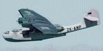
This folder contains a repaint for the Aerosoft PBY Catalina for FSX, representing PBY-5 ZK-AMP of Tasman Empire Airways Ltd. The Royal New Zealand Air Force had 56 Catalina's in all between 1943 and 1953. They were registered NZ4001-4056 inclusive and included 22 PBY-5s (mostly MklVAs) with the remainder being PB2B-1 s. All were flying boats, with no amphibian models being taken on charge. After the war only half a dozen or so of the best aircraft were maintained in service with No 5 Sqn (squadron code became PA-) and fitted with the latest search radar which had a large radome behind the cockpit. The remainder were put into storage. Two PB2B-ls were loaned to Tasman Empire Airways Ltd (TEAL) for short periods after the war, one (which became ZK-AMI) as a crew trainer, the other (ZK-AMP, former NZ4038 PA-J) to survey a flying boat route from Fiji to Tahiti, later to become known as "The Coral Route" and used by TEAL's Solent flying boats. These two aircraft were eventually returned to the RNZAF before being scrapped.
I have included two versions, one for P3Dv5 (without reflections) and one for the earlier sims (FSX/P3Dv1-4), with slight reflections. I felt these were too shiny in v5, but feel free to try for yourself.
I did paint this aircraft earlier, this paint has been adapted and improved on all fronts.
| Filename: | Consolidated_PBY5A_ZKAMP_TEAL.zip |
| License: | Freeware |
| Added: | 5th June 2020, 21:00:57 |
| Downloads: | 190 |
| Author: | Jan Kees Blom |
| Size: | 21.17 MB |
| Category: Flight Simulator 2004 - Scenery | |
| Lechfeld, v2 |
|
Images related to this file:
File Description:
This airbase, located about 35 NM in the west of Munich (Bavaria, South Germany),
is the homebase of JaBoG32 riding the Tornado PA200. The German flight check
department GMFS, using C-47 in the early days and thereafter Hawker-Siddeley 748
as well as HS-125 for periodic recalibration of the radar- and navigational
equipment at civil and military airfields, was also on the base till 1994.
After the final decision was made not to establish commercial air traffic although
it had been discussed for a long time period, I reworked the airbase completely.
Among other objects, 38 hardened shelters for combat aircraft have been emplaced.
The included AI-Package contains: Lockheed F-104E GAF, Panavia Tornado PA200 GAF,
Mikoyan MiG-29 GAF, Douglas C-47 GAF, Canberra B.20 GAF, Boeing E3A Nato, Boeing
KC-135 USAF and an aircraft.cfg for the MS Learjet 45.
Several F104's, Tornadoes and MiGs perform touch and goes in the local area,
a Nato E3A leaves IFR to Geilenkirchen (ETNG), an USAF KC-135 routes IFR to
Decimomannu (LIED), a Canberra B.20 (was used for high altitude validations) goes
IFR to Cologne (EDDK) high in the sky and a Learjet shoots IFR to Bremen (EDDW) per
attached flight plan.
Lago's FSE is required in order to see most of the emplaced buildings /objects.
Lets get ready to rumble, but keep in mind, don't argue with the flight checkers
if they are on duty.
| Filename: | Lechfeld_v2.zip |
| License: | Freeware |
| Added: | 12th April 2011, 13:26:46 |
| Downloads: | 1,419 |
| Author: | Klaus Jone |
| Size: | 5.43 MB |


© 2001-2026 AVSIM Online
All Rights Reserved
Privacy Policy |