
Where Flight Simulation Enthusiasts Gather from Around the World!
AVSIM Library - Search Results

| Category: Flight Simulator X - Scenery | |
| Southern California Scenery Enhancements v2.0 |

|
File Description:
This is a compilation of the Scenery Enhancements that I have uploaded over the past year. Enhancements include KMHV Mojave Airport, KTSP Tehachapi Municipal Airport, KVBG Vandenberg AFB, Palm Springs Windmill Farm & So. Cal Oil Rigs v2.1. All Rwy12 Object Libraries textures have been included; meaning that ANY scenery enhancement requiring Rwy12 Objects Textures will work. These enhancements have been conveniently placed in a simple installation file. This file is for FS-X ONLY!
| Filename: | Southern_California_Scenery_Enhancements_v20.zip |
| License: | Freeware |
| Added: | 7th December 2006, 11:20:22 |
| Downloads: | 5,584 |
| Author: | Brian C. Selb |
| Size: | 39.71 MB |
| Category: Flight Simulator X - Scenery | |
| Sharm El Sheikh Photoreal Scenery |
|
Images related to this file:
File Description:
Sharm El Sheikh (Egypt) Photoreal Scenery
| Filename: | Sharm_El_Sheikh_Photoreal_Scenery.zip |
| License: | Freeware |
| Added: | 9th February 2020, 17:10:03 |
| Downloads: | 299 |
| Author: | Mohamed Nassef |
| Size: | 14.79 MB |
| Category: Flight Simulator 2004 - Scenery | |
| GERMANY 2004 SRTM MESH SCENERY |
|
File Description:
Based on SRTM 3 arc.sec data.
Unfortunately SRTM DATA have many holes and data loss, so I made a resampling and an oversampling with other data with lower resolution, but with better coverege (like data from swiss topographic federal istitute or from italian IGM, and finally with DTED Level 0.) with geo cad software like Grass and GlobalMapper for projection convertion.
Compression and conversion to bgl with MS Flight simulator SDK at LOD 9
This scenery cover the entire Germany teritory, the part of Swiss and Austria territories not included in my Italian scenery. Parts of Belgium and Netherlands and Luxembourg are included too (Till E005); next quite the whole territory of Czech Republic and part of Poland till E017.
| Filename: | GERMANY_2004_SRTM_MESH_SCENERY.zip |
| License: | Freeware |
| Added: | 23rd November 2003, 23:18:46 |
| Downloads: | 25,903 |
| Author: | Pietro Mauri |
| Size: | 62.08 MB |
| Category: Flight Simulator 2004 - Scenery Design | |
| FREEflow water scenery generation tutorial |
|
File Description:
FREEflow - A method for automated generation of water scenery for use with Microsoft Flight Simulator. This quick-start guide will illustrate how to employ TerraScene 2.1 (by Todd Klaus) in combination with Slartibartfast (by Jim Keir) to almost automatically create lakes, rivers, and coastal shorelines for Microsoft Flight Simulator. (Other downloads required, details in document). Suitable for all - beginners and experts alike.
| Filename: | FREEflow_water_scenery_generation_tutorial.zip |
| License: | Freeware, limited distribution |
| Added: | 17th March 2005, 13:26:29 |
| Downloads: | 2,621 |
| Author: | Scott Gridley |
| Size: | 1.58 MB |
| Category: Flight Simulator 2004 - Scenery Design | |
| Iqaluit CYFB 2010 Scenery Village |
|
Images related to this file:
File Description:
This adds a simple representation of the village of Iqaluit to my Iqaluit CYFB 2010 scenery. It requires that you already have the Iqaluit CYFB 2010 scenery and the Iqaluit CYFB 2010 v1.1 patch installed. It also requires that you download and install the Iqaluit_CYFB_2010_Village.zip object library. (I forgot to mention this in the original instructions. Sorry.) All three are available on either Avism.com or Flightsim.com.
| Filename: | Iqaluit_CYFB_2010_Scenery_Village.zip |
| License: | Freeware |
| Added: | 27th March 2011, 02:42:50 |
| Downloads: | 945 |
| Author: | Sidney Schwartz |
| Size: | 7.29 KB |
| Category: Flight Simulator 2004 - Scenery Design | |
| Scenery Design Corrected API'S Trees |
|
File Description:
FS2004 Scenery Design CORRECTED API'S TREES
If you are having any problems with my trees
NOT being transparent before this date - I forgot
to code the api for transparent textures.
Simply replace my former apis with these.
| Filename: | Scenery_Design_Corrected_APIS_Trees.zip |
| License: | Freeware |
| Added: | 27th October 2003, 00:10:25 |
| Downloads: | 802 |
| Author: | jimmy R martin |
| Size: | 6.58 KB |
| Category: Flight Simulator 2004 - Scenery Design | |
| Box Truck Scenery Object Library |
|
File Description:
Box Truck Scenery Object Library FS2004.
This is a small library of 'box' trucks in various liveries. Created for use with 'Instant Scenery' or similar object placement program.
I built the models in Gmax and have kept the poly count as low as possible. Textures were created as DXT1 (mipped) and every truck has its own realistic night time textures. All objects have been tested in FS2004 in Dawn,Day,Dusk and Night environments. Please review the readme file contained within the archive.
| Filename: | Box_Truck_Scenery_Object_Library.zip |
| License: | Freeware, limited distribution |
| Added: | 4th December 2007, 12:15:39 |
| Downloads: | 3,822 |
| Author: | Drew Bunting |
| Size: | 1.67 MB |
| Category: Flight Simulator X - Scenery | |
| Algiers City PhotoTerrain Scenery X |
|
Images related to this file:
File Description:
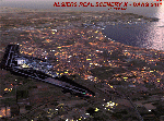
FSX Algiers City Photo Terrain by Riad GHENIM
Algiers City, DAAG, Algeria. A mediterranean city with its beautiful coasts. Beta version.
This photo terrain scenery works with Algiers Real Scenery DAAG for FSX
| Filename: | Algiers_City_PhotoTerrain_Scenery_X.zip |
| License: | Freeware |
| Added: | 3rd June 2011, 22:28:46 |
| Downloads: | 13,026 |
| Author: | Riad Ghenim |
| Size: | 25.34 MB |
| Category: Flight Simulator X - Scenery | |
| South America Mesh Scenery, MeshX_A12 |
|
File Description:
Mesh terrain scenery for the whole continental South America, based on SRTM 90m
dem geotiff files (at: ftp://ftp.glcf.umiacs.umd.edu/glcf/SRTM/Degree_Tiles/),
resampled to 76 meter of horizontal resolution (LOD 9). The new files have
improved the vertical resolution from 16m to 10m, resulting in more details
and accuracy over previous versions. There are 50 files, compatible with FS 9
and FS X, identified in a map by column letter and line number, covering the
contiguous countries and states. Boundaries: N = 50º 37.5' S; S = 56º 15' S;
E = 71º 15' W; W = 78º 45' W.
| Filename: | South_America_Mesh_Scenery_MeshX_A12.zip |
| License: | Freeware |
| Added: | 30th October 2006, 05:45:01 |
| Downloads: | 1,956 |
| Author: | Oséas Dourado and José Lôbo |
| Size: | 13.36 MB |
| Category: Prepar3D V1-4 - Scenery | |
| Israel Coastline Scenery - Part 4 |
|
File Description:
This Is Israel Coastline Scenery.
It cover most of Israel coastline with photorealistic ground and with updated objects. Well, it called "€œIsrael Coastline" but it also includes some objects inside Israel'€™s €œmainland€Â.
It features updated buildings in Tel Aviv area (As of 2016), Netanya, Haifa, Ashdod, Rishon Le Ziyon and Ben Gurion airport area and night textures.
| Filename: | Israel_Coastline_Scenery__Part_4.zip |
| License: | Freeware |
| Added: | 13th May 2016, 18:11:41 |
| Downloads: | 1,506 |
| Author: | Bar Rodoy and Tomer Haim |
| Size: | 66.72 MB |


© 2001-2026 AVSIM Online
All Rights Reserved
Privacy Policy |