
Where Flight Simulation Enthusiasts Gather from Around the World!
AVSIM Library - Search Results

| Category: Flight Simulator 2002 - Flight Plans | |
| 'On the Road' Cross-Country Flight Plans |

|
File Description:
Flight Plans for a Cross-Country Flight following the route of Sal Paradise' 1st journey to the West Coast and back from Kerouac's famous novel: "On the Road". 2 alternative routes: "Jet Route" uses only international airports, "Prop Route" uses mostly regional / municipal / city airports (more stops). FS2000, FS2002 and FS Navigator formats.
| Filename: | On_the_Road_CrossCountry_Flight_Plans.zip |
| License: | Freeware |
| Added: | 12th February 2003, 00:35:54 |
| Downloads: | 1,529 |
| Author: | Csaba Sághi |
| Size: | 1.07 MB |
| Category: Flight Simulator X - Utilities | |
| FsLaunchpad-2.0 |
|
File Description:
FS2004/FSX/Prepar3D Utility--FsLaunchpad 2.0. Here new features of FSLaunchpad 2.0: Start more rapidly without blinking Launching message; New functionality to create a Google Earth file from flight plan and see airports and your adds-on near from each waypoint. Compatible with FSX, P3D, FS2004 and Plan-G Flight Plans; Select your Addon sceneries from flight plan result search; More than 400 airports for Google Earth Search. All 24490 airports from FSX instead of 24014 airports from FS2004; Each Airport Google Earth popup now includes links for weather from Aviation Digital Data Service (ADDS) and airport information from wikipedia and more. Improve addons source and destination separators; Detect if you run FSL as Administrator. Tested with Windows 7, 8 and 10. By Pierre Legault.
| Filename: | FsLaunchpad20.zip |
| License: | Freeware, limited distribution |
| Added: | 28th August 2015, 02:14:24 |
| Downloads: | 547 |
| Author: | Pierre Legault |
| Size: | 3.28 MB |
| Category: Flight Simulator 2004 - Scenery | |
| Marshall Islands |
|
File Description:
Basic scenery and AFCAD files to create 21 new airstrips in the Republic of the Marshall Islands, and to add facilities to 12 of the default FS9 Marshall Island airports. Also 2 sets of AI flightplans for Air Marshall Islands.
New airstrips: AIC Airuk/Airok, AIM Ailuk, AUL Aur, BII Eneu (Bikini Atoll), EBN Ebadon, EAL Elenak, EBO Ebon, EJT Enajet/Enijet/Enejit, JAT Jabwot/Jabot, JEJ Jeh, KBT Kaben/Kapen, LIK Likiep, LML Lae, LOF Loen, MJE Majkin, NMU Namu, RNP Rongelap, TBV Tabal, UJE Ujae, WJA Woja, WTO Wotho.
Afcads for FS9 airports: 1Q9 Mili, N55 Jaluit, PKMA Enewetak, PKRO Dyess/Roi-Namur, Q30 Mejit, N36 Wotje, 3N1 Taora/Maloelap, N18 Tinak, N20 Ine, Q51 Kili, 3N0 Namorik/Namdrik, 03N Utirik.
| Filename: | Marshall_Islands.zip |
| License: | Freeware |
| Added: | 12th September 2005, 12:18:51 |
| Downloads: | 2,865 |
| Author: | Adrian Wright |
| Size: | 438.48 KB |
| Category: Flight Simulator 2004 - Scenery | |
| VEAT Argatala, India |
|
Images related to this file:
File Description:
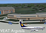
Googly scenery for VEAT Argatala, India - one of the airports that Microsoft seem to have, um, "forgotten" in FS2004. In the real world it is regularly served by Boeings and Airbii of Alliance Air, Indian Airlines, Jet Airways and Kingfisher Airlines (and smaller aircraft), using the 6000 foot runway with little room for manoevre. These scenery files add aprons, taxiways, buildings and other airport features to Flight Simulator's bland representation and allow you, and "AI" traffic, to land, taxi, park and take off realistically. The scenery does not purport to be ultra-accurate. Based on high-detail satellite imagery from Google Earth, the layout is proportianally correct but the added airport features, such as buildings, are built from default Microsoft objects and add-on libraries so will not look like the real thing. You are not obliged to download and install any additional scenery libraries, but to enjoy this scenery in its entirety, you may wish to. It will work fine, with or without. Details of optional additional scenery library downloads are provided within.
[File re-uploaded at request of AVSIM]
| Filename: | VEAT_Argatala_India.zip |
| License: | Freeware |
| Added: | 14th May 2010, 04:49:05 |
| Downloads: | 1,658 |
| Author: | John Hinson |
| Size: | 65.16 KB |
| Category: Flight Simulator X - AFCAD Files | |
| South Australian AFCADS Pack 4 |
|
File Description:
Some upgraded but mostly new airports that were not released in FSX. Mostly small general aviation, gliding clubs etc.
| Filename: | South_Australian_AFCADS_Pack_4.zip |
| License: | Freeware |
| Added: | 2nd October 2007, 03:11:36 |
| Downloads: | 595 |
| Author: | Kym Burton |
| Size: | 15.36 KB |
| Category: Flight Simulator X - Scenery | |
| Placencia Municipal Airport, Belize |
|
File Description:
One of Belize's poorly documented airports, that are nevertheless serviced by two local airlines with several flights a day.
| Filename: | Placencia_Municipal_Airport_Belize.zip |
| License: | Freeware, limited distribution |
| Added: | 31st December 2007, 21:52:36 |
| Downloads: | 638 |
| Author: | Alf B. Meier |
| Size: | 121.52 KB |
| Category: Flight Simulator X - Scenery | |
| Nunavut Landscape - Canada |
|
File Description:
Elevation data (mesh-Lod10), land cover, water polygons, rivers, stream lines, lanes and shorelines around airports of Nunavut, Canada
| Filename: | Nunavut_Landscape__Canada.zip |
| License: | Freeware, limited distribution |
| Added: | 20th November 2010, 00:10:27 |
| Downloads: | 2,512 |
| Author: | Gilles Gauthier |
| Size: | 49.62 MB |
| Category: Navigation and ATC - Navigation | |
| Italian Airports Charts and Procedures Series 2 Update 14_11_2013 |
|
File Description:
All Italian Airports in PDF Format to use with ChartMap vers. 5.0. This is the second of three series.
| Filename: | Italian_Airports_Charts_and_Procedures_Series_2_Up.zip |
| License: | Freeware |
| Added: | 24th November 2013, 05:55:56 |
| Downloads: | 193 |
| Author: | Carlo Chiappisi |
| Size: | 85.99 MB |
| Category: Navigation and ATC - Navigation | |
| Italian Airports Charts and Procedures Series 3 Update 14_11_2013 |
|
File Description:
All Italian Airports to use with ChartMap 5.0. This is the last file of the series.
Download ChartMap 5.0
| Filename: | Italian_Airports_Charts_and_Procedures_Series_3_Up.zip |
| License: | Freeware |
| Added: | 24th November 2013, 05:56:35 |
| Downloads: | 229 |
| Author: | Carlo Chiappisi |
| Size: | 78.44 MB |
| Category: Flight Simulator 2004 - AI Flight Plans | |
| Rockhopper Summer 05 |
|
File Description:
Summer 2005 AI flightplans for Rockhopper who serve the following airports:
Jersey, Guernsey, Alderney, Bournemouth, Brighton and St. Brieuc
| Filename: | Rockhopper_Summer_05.zip |
| License: | Freeware |
| Added: | 21st May 2005, 00:38:52 |
| Downloads: | 468 |
| Author: | Robert Holland |
| Size: | 5.53 KB |


© 2001-2026 AVSIM Online
All Rights Reserved
Privacy Policy |