
Where Flight Simulation Enthusiasts Gather from Around the World!
AVSIM Library - Search Results

| Category: Flight Simulator 2004 - Scenery | |
| Himalayas LOD9 Base Mesh, Volume 3 - Southwestern Ranges |

|
Images related to this file:
File Description:
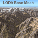
Detailed terrain mesh of the Southwestern Himalayan Ranges, N28-37 E78-82. The files in this package are based on Shuttle Radar (SRTM) Version 2 data but with many of the void areas, especially the most significant sections, filled with elevation data generated from topographic maps by Jonathan de Ferranti. While Jonathan's work is unrelated to flight simulation he kindly gave me permission to compile his data for use in FS. The result is a wonderful improvement in detail and accuracy over any existing mesh file, freeware or commercial, based on SRTM or DTED data alone.
Due to the large area of the Himalayas I've compiled the source data as two separate series: the "Himalayan Peaks" series covers prominent mountains and ranges in higher detail and locally overrides any existing LOD9 terrain mesh. In addition, the LOD9 "base mesh" series, with LOD8 and LOD7 "buffer" mesh files, covering the entire Himalayas, is meant for those who do not yet have an add-on terrain mesh of these beautiful mountains.
| Filename: | Himalayas_LOD9_Base_Mesh_Volume_3__Southwestern_Ra.zip |
| License: | Freeware, limited distribution |
| Added: | 30th May 2010, 10:00:26 |
| Downloads: | 155,808 |
| Author: | Holger Sandmann, Jonathan de Ferranti |
| Size: | 62.16 MB |
| Category: Flight Simulator X - Aircraft Repaints, Textures and Modifications | |
| General Dynamics F-16D Block 52 Egyptian Air Force (Peace Vectors Tail) |
|
Images related to this file:
File Description:

This is a repaint of the Kirk Ollson F-16D Model, texture created, modified and enhanced to form the F-16D Block 52 of the EAF
The repaint is an Egyptian Air Force F-16D 2 seater fighting falcon, It is a falcon of the 25th anviersary
of the Peace Vectors program, in which Egypt first aquired F-16's and continues to do so at this moment.
The tail has a Peace Vectors stamp or sticker on it with high readable quality.
The repaint and tail is photorealistic with many photos used to create the repaint.
if you have any comments or questions, please visit my website at: http://www.projecthighsky.110mb.com
The original model is made by Kirk Ollson
Repaint made by Joseph Botros
This is an FSX-Only repaint (textures were updated to work with FSX only, it may work in FS9, though not
tested, install to FS9 at your own risk. 100% compatible with FSX.
You need "f16d_X.zip" for this repaint. Can be found at FS-freeware.com
| Filename: | General_Dynamics_F16D_Block_52_Egyptian_Air_Force_.zip |
| License: | Freeware |
| Added: | 17th July 2010, 23:33:07 |
| Downloads: | 304 |
| Author: | Joseph Botros (Kirk Ollson) |
| Size: | 3.42 MB |
| Category: Flight Simulator 2004 - Scenery | |
| Cape Dorset CYTE, Baffin Island, Nunavut, Canada |
|
Images related to this file:
File Description:
Cape Dorset is a village of 1,300 or so inhabitants at N 64 13 W 76 31 on Dorset Island, off the southwest corner of Baffin Island. It's Inuit name is Kinngait, which means "High Mountains"; watch out if you fly there in low clouds. The village (again) does not feature in FS9 but is included in this scenery with approximately the right shape, or shapes as there are separate parts. The airfield runway is just under 4,000 feet of gravel 100 feet wide at 158 feet above sea level. There is a double gradient to it, but unfortunately this cannot be replicated in FS.
Cape Dorset had a Hudson Bay Company store as long ago as 1913, and is now known as a centre for Inuit art. I added the roads, a new airfield background, a pond between apron and runway, plus of course there is the scenery file and the AFCAD and AI, which has two planes visiting, a First Air HS748 and a Canadian North Dash 8-100, as per real life.
| Filename: | Cape_Dorset_CYTE_Baffin_Island_Nunavut_Canada.zip |
| License: | Freeware, limited distribution |
| Added: | 9th December 2010, 18:45:06 |
| Downloads: | 1,014 |
| Author: | Roger Wensley |
| Size: | 2.75 MB |
| Category: Flight Simulator 2004 - Scenery | |
| Himalayas LOD9 Base Mesh, Volume 4 - Kashmir and Jammu |
|
File Description:
Detailed terrain mesh of the Kashmir and Jammu Ranges, N30-39 E76-78. The files in this package are based on Shuttle Radar (SRTM) Version 2 data but with many of the void areas, especially the most significant sections, filled with elevation data generated from topographic maps by Jonathan de Ferranti. While Jonathan's work is unrelated to flight simulation he kindly gave me permission to compile his data for use in FS. The result is a wonderful improvement in detail and accuracy over any existing mesh file, freeware or commercial, based on SRTM or DTED data alone.
Due to the large area of the Himalayas I've compiled the source data as two separate series: the "Himalayan Peaks" series covers prominent mountains and ranges in higher detail and locally overrides any existing LOD9 terrain mesh. In addition, the LOD9 "base mesh" series, with LOD8 and LOD7 "buffer" mesh files, covering the entire Himalayas, is meant for those who do not yet have an add-on terrain mesh of these beautiful mountains.
| Filename: | Himalayas_LOD9_Base_Mesh_Volume_4__Kashmir_and_Jam.zip |
| License: | Freeware, limited distribution |
| Added: | 22nd February 2006, 20:32:50 |
| Downloads: | 7,504 |
| Author: | Holger Sandmann, Jonathan de Ferranti |
| Size: | 29.24 MB |
| Category: Flight Simulator X - Scenery | |
| Wynoochee Lake WA - (Bob's Fly-in Cabin) |
|
File Description:
Wynoochee Lake WA (Bob's Fishing Cabin) - Airport ID: BOB (FSX). - -
This is a fictitious fly-in lodge that I created for a quiet spot to fly into for weekend trips from the Seattle area. My cabin is located about 40 miles due south of Port Angeles, WA and about 50 miles due west of Seattle. - -
Wynoochee Lake is a real location, but my scenery around the lake is fictitious. - -
You will find my dirt airstrip to be quite challenging, although completely fly-able. My location is even more challenging at dawn or dusk with Weather. There are no approach lights, its just a rugged bush strip. - -
It is extra challenging with crash detection turned on - watch out for those birds, they're everywhere and that old tree just of the side of the dirt strip - don't get too close! - -
This is freeware. I hope you enjoy it. - -
Designed with the FS X Sdk Scenery function of the Mission builder,Abacus Scenery shortcut tool and Lee Swordy's AFCAD. - -
This scenery is frame rate friendly. - - Please read the "readme" - -
by Bob Caparoula
www.flydeervalley.com
| Filename: | Wynoochee_Lake_WA___Bobs_Flyin_Cabin.zip |
| License: | Freeware |
| Added: | 2nd February 2007, 21:10:37 |
| Downloads: | 1,456 |
| Author: | Bob Caparoula |
| Size: | 4.64 KB |
| Category: Flight Simulator 2004 - AI Aircraft | |
| Microlights- Vol.2 |
|
File Description:
Three more low-polygon count models for AI use in F2004, all tail-draggers, one based on the AirBike, with two seats, the second based on the Weedhopper, the third based on the Affordaplane. I've only included one or two texture sets for each aircraft, but I have included basic repaint templates for the Airbike and the Weedhopper, so you can generate a multitude of brightly-coloured aircraft to your own taste in a few minutes.
Each model includes three LOD models and a reduced-detail shadow model, for improved visual performance, and to this end I have also included updated models for my previous "Microlights for AI" upload (required for the textures if you want these aircraft). Although the model file size will be bigger, because FS only loads the LOD model it requires for the given range of the aircraft, once the aircraft is more than a few hundred feet away from the viewpoint, it will affect the frame-rate less than the originals.
Please see the enclosed text file for further details.
| Filename: | Microlights_Vol2.zip |
| License: | Freeware, limited distribution |
| Added: | 24th June 2007, 21:49:45 |
| Downloads: | 522 |
| Author: | Chris Eve |
| Size: | 607.56 KB |
| Category: Flight Simulator 2004 - Utilities | |
| Traffic View Board Version 2.1 |
|
File Description:
Traffic View Board is a new AI view gauge file that will give you an overview of the AI traffic without the need of external programs. This package works like a regular user aircraft and must be installed in the FS "Aircraft" folder. Instead of a regular aircraft model, this model is invisible, and the regular panel is replaced with a traffic board (similar to those found at any airport). When powered on you may choose between "Arrival", "Departure", "In flight" and "On ground". Each flight in the traffic board list represents an AI aircraft in FS2004. By clicking on a flight form the list, that particular aircraft is selected. When activating the "Follow aircraft" button the user aircraft are mapped to the AI aircraft position. This little trick allows you to spot that AI aircraft from any view in FS2004. FS2004 is still "looking" towards the user aircraft, but as the user aircraft are mapped to the AI aircraft FS2004 is "looking" towards the AI aircraft as well.
| Filename: | Traffic_View_Board_Version_21.zip |
| License: | Freeware |
| Added: | 29th October 2004, 22:38:48 |
| Downloads: | 54,514 |
| Author: | Arnt Helge Haland |
| Size: | 479.8 KB |
| Category: Flight Simulator 2004 - Scenery Design | |
| Simple Instructions for Modifying Land Class |
|
File Description:
Simple Instructions for Modifying Land Class
Land classification, or land class (NOT "landclass"), is how Flight Simulator depicts the ground textures. For much of the FS world, the ground is not representative of the real thing, however. There have been complaints because of this from those who do not understand the cause of the problem.
This document explains the basic concepts behind the land class system, why it is inevitably inaccurate for most of the world, and the very easy-to-use tools with which to fix this.
Also includes instructions for modifying water class.
This is an html document for universal compatibility.
You do not have to be a computer programmer in order to change the land class. Anyone can do it quickly and easily.
So, why complain about it? Do something!
Very sorry - no support of any kind is offered for this document. Please consult the AvSim Scenery Design forum for any questions.
| Filename: | Simple_Instructions_for_Modifying_Land_Class.zip |
| License: | Freeware |
| Added: | 6th February 2005, 04:24:20 |
| Downloads: | 5,072 |
| Author: | Luis, scenery design forum |
| Size: | 2.18 MB |
| Category: Flight Simulator 2004 - Utilities | |
| TweakFS Zip Utility |
|
File Description:
The TweakFS Zip Utility is a useful tool for unpacking Zip files downloaded from FS file libraries without the need for an existing 3rd-party Zip application. It is "FS2004 aware" and can automatically detect the FS9 folder location. Due to this feature it has several handy folder location presets which makes it quick and easy to install aircraft, scenery and other addons which come in Zip files that include folder path information. It has a small file size when zipped (about 760 KB) and can be freely distributed by freeware/commercial developers to help users install their files. The Create Zip tab also supports Zip Comments for adding any other information such as copyright notices. Features: Create and Extract Zips (no 3rd-part Zip program required), drag and Drop Zip file creation, graphical view of the folder structure within a Zip file, extracts to any select location or to special preset folders in FS9, compress and Extract with/without folder structure, add comments to Zip files, graphical Zip/Unzip progress meters, warns if the FS9 registry path is incorrect.
| Filename: | TweakFS_Zip_Utility.zip |
| License: | Freeware |
| Added: | 29th July 2005, 04:10:28 |
| Downloads: | 1,731 |
| Author: | Fermin Fernandez (TweakFS) |
| Size: | 800.5 KB |
| Category: Flight Simulator 2004 - Gauges | |
| VTOL/Hover gauge for Adam Preece' GR7 Harrier, V1.1 |
|
File Description:
If you use the previous version (RCBhcb10.zip): this version corrects a problem where the gauge gave problems when transitioning from hover to normal flight if you had loaded the aircraft in SpotPlane view. Plus some minor improvements.
See README for upgrade instructions.
This freeware gauge adds a whole new flightmodel and new VTOL & Hover featuresto Adam Preece' freeware Harrier.
Besides true vertical takeoff&landing, it allows you to fly forward, backward, sideways and turn, while in a hover.
This solution is based on overriding the normal FS flightdynamics while in a
hover, simular to the implementation of catapult launch / cable arrest in my
Carrier Operation Package; in short, it's a VTOL&Hover FDE coded in a gauge.
Special thanks to Doug Dawson, who created a gauge that provides for overriding FS2004 variables from an XML gauge.
Besides a VTOL controller, it also contains an effects controller plus visual
effects, for things like wingtip vortex, directional engine smoke and a cannon.
Requires FSUIPC (registered or unregistered).
The README includes extensive installation and flying instructions.
By Rob Barendregt.
| Filename: | VTOLHover_gauge_for_Adam_Preece_GR7_Harrier__V11.zip |
| License: | Freeware, limited distribution |
| Added: | 9th December 2005, 12:49:31 |
| Downloads: | 2,084 |
| Author: | Rob Barendregt |
| Size: | 88.49 KB |


© 2001-2026 AVSIM Online
All Rights Reserved
Privacy Policy |