
Where Flight Simulation Enthusiasts Gather from Around the World!
AVSIM Library - Search Results

| Category: Flight Simulator X - Scenery | |
| Working TACAN Beacons in the Netherlands, version 2 |

|
Images related to this file:
File Description:
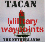
In real-life TACAN beacons require a TACAN receiver to receive the course (OBS)
information of the beacon. With a civil VOR/DME receiver you only receive the
distance (DME) to the beacon.
The problem in FS is that there are no dedicated TACAN gauges, so it's not
possible to perform TACAN approaches, because this requires course information
of the beacon.
To overcome this problem i've modified the TACAN beacons in the Netherlands so
you can fully use them with civil receivers. And so are able to fly TACAN
approaches.
Also added almost all military waypoints in the Netherlands for various military
routes. These will show up in the default GPS and other gauges which use the
default FS database. Build and tested under FSX, should however also work under
FS2004.
| Filename: | Working_TACAN_Beacons_in_the_Netherlands_version_2.zip |
| License: | Freeware, limited distribution |
| Added: | 20th April 2014, 13:26:49 |
| Downloads: | 264 |
| Author: | Marcel Ritzema |
| Size: | 22.05 KB |
| Category: Online ATC - Software | |
| VAT-Spy addition, the ICAO airport code V |
|
File Description:
VA VE VI VO - India
VA - Mumbai Center (VABF)
VE - Kolkata Center (VECF)
VI - Delhi Center (VIDF)
VO - Chennai Center (VOMF)
VC - Sri Lanka
VD - Cambodia
VG - Bangladesh
VH - Hong Kong
VL - Laos
VM - Macau
VN - Nepal
VQ - Bhutan
VR - Maldives
VT - Thailand
VV - Vietnam
VY - Myanmar (Burma)
| Filename: | VATSpy_addition_the_ICAO_airport_code_V.zip |
| License: | Freeware |
| Added: | 17th June 2014, 16:21:19 |
| Downloads: | 53 |
| Author: | Porutchikov Fedor |
| Size: | 1.06 MB |
| Category: Flight Simulator X - Aircraft Repaints, Textures and Modifications | |
| "Pride of the Middle East" Boeing 777-200LR |
|
File Description:
Textures only for the PMDG B777-200LR model.
Plane textures are based on one of the Emirates A320s (http://www.cardatabase.net/modifiedairlinerphotos/photos/big/00013930.jpg).
| Filename: | Pride_of_the_Middle_East_Boeing_777200LR.zip |
| License: | Freeware |
| Added: | 29th August 2014, 16:16:57 |
| Downloads: | 1,031 |
| Author: | Por Por Tapatt |
| Size: | 14.02 MB |
| Category: Flight Simulator X - Scenery | |
| Air Station Poznan Lawica in the interwar years |
|
File Description:
Air Station Poznan-Lawica is one of the oldest airports in Poland. Built in 1913 as an Imperial German airbase (Fliegerstation Lawitz). During the Wielkopolskie (Greater Poland) Uprising on January 6, 1919 was captured by insurgents. As the first insurgent air unit, began to play a very important role in the development of Polish aviation and Polish Air Force.
The Air Station Poznan-Lawica was one of the most important Polish airports in the interwar years.
| Filename: | Air_Station_Poznan_Lawica_in_the_interwar_years.zip |
| License: | Freeware, limited distribution |
| Added: | 28th October 2014, 12:33:07 |
| Downloads: | 647 |
| Author: | Rob Kowalski |
| Size: | 16.05 MB |
| Category: Flight Simulator 2004 - Aircraft Repaints, Textures and Modifications | |
| "Rotterdam The Hague Airport" Boeing 737-800 - Fictional |
|
Images related to this file:
File Description:
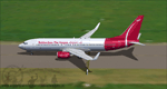
This is an Boeing B737-8RT in the promo fictional Rotterdam The Hague Airport.nl colors of an scale model at the information desk at Rotterdam The Hague Airport The Netherlands Registration: PH-RTM, Repaint By: Mathieu Vos (APSS), Model By: TDS. Also compatible with FSX.
| Filename: | Rotterdam_The_Hague_Airport_Boeing_737800__Fiction.zip |
| License: | Freeware |
| Added: | 20th December 2015, 16:31:18 |
| Downloads: | 343 |
| Author: | Mathieu Vos (APSS) |
| Size: | 12.69 MB |
| Category: Flight Simulator 2004 - Aircraft Repaints, Textures and Modifications | |
| Aerosur "The Wave" Boeing 727-200 (CP-2424) |
|
Images related to this file:
File Description:
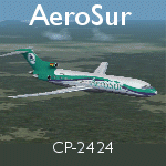
Aerosur Boeing 727-200, Registration CP-2424. Circa 2010. Textures only for the TDS 727-200 model. Download the base package from Flightsim.com: tds_b727-200.zip or tdsx_b727-200.zip. Repainted by Hernan Anibarro.
| Filename: | Aerosur_The_Wave_Boeing_727200_CP2424.zip |
| License: | Freeware |
| Added: | 27th July 2016, 21:00:45 |
| Downloads: | 240 |
| Author: | Hernan Anibarro / TDS |
| Size: | 6.56 MB |
| Category: Flight Simulator 2004 - Scenery | |
| Kotzebue PAOT on the northwestern coast of Alaska |
|
Images related to this file:
File Description:
There are four main northwestern Alaska towns which have good airports and are serviced by Alaska Airlines. From these airports local flights connect to nearby villages, "nearby" in Alaska meaning up to 150 miles away. The northernmost is Barrow. Southwest of Barrow is Kotzebue, then Nome, and the furthest south is Bethel. The town of Kotzbue is north of the Bering Strait on the northwestern coast, 320 miles southwest of Barrow. The population is just over 3,000 people. The location was for a long time a base for trading in furs, with three rivers emptying into the sea and providing routes into the interior land and villages; a meeting place between hunters and traders from Russia and elsewhere. The Kotzebue airport is called the Ralph Wien Memorial and has two runways. The modern one is aligned 08-26 and is 5,880 feet of 150 feet wide asphalt built across a shallow lagoon, with an ILS on 08 and PAPI on both ends. The second and older runway is originally military and gravel, aligned 17-35 and 3,786 feet long and used (wind allowing) by the GA planes that park alongside the runway. The prevalent wind is from the west; when the wind is from the east it is generally relatively feeble and with a much lower cloud base, possibly to the ground, hence the need for an ILS. All AI aircraft in FS9 much prefer to use a runway that has an ILS and so will continue to use 08-26 even if the wind is from the south until it reaches 30+ knots, even if they are a Cessna 150 flying VFR. So for AI realism in FS9 a northern or southern wind needs to be a strong one so that the runway is actually used. However, as Alaska Airlines, Northern Air Cargo, and Everts Air also fly to Kotzebue and can only use the east-west runway (as less than 4,000 feet of asphalt would be seriously inconvenient for a Boing 737 or DC6) it is necessary to have the northern or southern wind UNDER 30 knots at the times when they are landing or taking off. Your choice. I suppose a permanent strong wind from the west would be the most realistic on a daily basis, deterring all planes from ever using 17-35. The AI will develop along with further scenery additions in the neighbourhood.
| Filename: | Kotzebue_PAOT_on_the_northwestern_coast_of_Alaska.zip |
| License: | Freeware, limited distribution |
| Added: | 2nd August 2016, 16:47:52 |
| Downloads: | 463 |
| Author: | Roger Wensley |
| Size: | 19.32 MB |
| Category: Flight Simulator 2004 - Scenery | |
| Nome PAOM on the northwestern coast of Alaska |
|
Images related to this file:
File Description:
There are four main northwestern Alaska towns which have good airports and are serviced by Alaska Airlines. From these airports local flights connect to nearby villages, "nearby" in Alaska meaning up to 200 miles away. The northernmost is Barrow. Southwest of Barrow is Kotzebue, then Nome, and the furthest south is Bethel. The town of Nome is south of the Bering Strait on the southern coast of the Seward Peninsula, around 185 miles south of Kotzebue, with a population of about 3,800. It is the town that led to the creation of the most famous dogsledge race in the world, the Iditarod, which is based on the delivery to Nome of diphtheria serum during the blizzard conditions of the winter of 1925. The Nome airport (it currently has no other name) was originally built as the last of the refuelling airfields for planes being ferried to Russia during WW2. It has two runways, aligned 09-27 and 02-20 in FS9 (the wandering magnetic north has recently renamed the magnetic headings) and both of them around 6,000 feet with an ILS on 27. There is a modern airport layout diagram included showing taxiway names etc. Alaska Airlines, ERA, and Bering Air (which is headquartered in Nome), along with the shared cargo terminal for Northern Air Cargo and Everts Air, are all on the southern apron. The northern apron is mainly for GA, along with maintenance facilities, a garage building that also houses a weather bureau, and at the far northern end of runway 02-20 an apron and hanger for the Alaska Air National Guard. All AI aircraft in FS9 much prefer to use a runway that has an ILS and so will continue to use 09-27 even if the wind is from the north or south, right up until it reaches 30+ knots, so for AI realism in FS9 a permanent wind from the west would be the most realistic on a daily basis. There is also a small gravel strip just north of the town and this is included (94Z), as are some old line-of-sight radio communication reflectors on the hills above the town. There is a note about making adjustments to Ultimate Terrain Alaska-Canada regarding both realistic road lighting and also auto-generation.
| Filename: | Nome_PAOM_on_the_northwestern_coast_of_Alaska.zip |
| License: | Freeware, limited distribution |
| Added: | 18th October 2016, 02:38:42 |
| Downloads: | 489 |
| Author: | Roger Wensley |
| Size: | 22.65 MB |
| Category: Flight Simulator 2004 - Miscellaneous Files | |
| Exta rear pages for the UK flight guide |
|
File Description:
12 extra rear pages for the UK and Ireland flight Guide
Plus important information regarding best way of storing and viewing the flight guide files.
**Please note Microsoft has a max length for file names,but for no good reason also includes the complete file extension path words in this maximum!
For this reason, please download each Zip file directly to your(My Computer/(C) Drive -(In my case),unzip and view from here as well - thus keeping the file extension length as short as possible. Anywhere else and it increases the file extension length such that some files cannot be opened or viewed.
More modern computers may have corrected this problem.**
| Filename: | Exta_rear_pages_for_the_UK_flight_guide.zip |
| License: | Freeware |
| Added: | 10th January 2017, 12:55:49 |
| Downloads: | 200 |
| Author: | Alan Trussell |
| Size: | 6.28 MB |
| Category: Prepar3D V1-4 - Miscellaneous Files | |
| Multi Crew Experience Flows for the A2A Constellation |
|
File Description:
Multi Crew Experience flows for the A2A Connie. Please note the Connie is not a Multi Crew Experience integrated aircraft. Therefore the flows use native FSX/P3d commands. Like wise the check lists are read only. The co pilot wont know where the switch is set. Since the Connie has a full A2A crew, this is merely an adjunct to help out with a co pilot performing extra actions commanded by you.
| Filename: | Multi_Crew_Experience_Flows_for_the_A2A_Constellat.zip |
| License: | Freeware |
| Added: | 11th September 2017, 22:37:36 |
| Downloads: | 143 |
| Author: | david herky |
| Size: | 47.49 MB |


© 2001-2026 AVSIM Online
All Rights Reserved
Privacy Policy |