
Where Flight Simulation Enthusiasts Gather from Around the World!
AVSIM Library - Search Results

| Category: Flight Simulator 2004 - Scenery | |
| Gustavo Rojas Pinilla International Airport (SKPS) 2011 |

|
File Description:
Gustavo Rojas Pinilla International Airport (IATA: ADZ, ICAO: SKSP) is the leading airport in the archipelago of San Andres, Providencia and Santa Catalina, which has enough capacity to receive large aircraft, due to a number of
charter flights and seasonal in different parts of America and Europe.
This file has the right coordinates, with the apron and characteristics of the airport. The runways were reoriented to the correct direction, runway were re-sized the gates placed on correct location and number, FAC was placed
(Colombian Air force and Colombian National Army) all the airport charts required to navigate in and out of this airport can be found at www.aerocivil.gov.co/ under Informacion Aeronautica click AIP; on AIP
click Aerodromos then click at SKSP.
| Filename: | Gustavo_Rojas_Pinilla_International_Airport_SKPS_2.zip |
| License: | Freeware |
| Added: | 23rd August 2011, 02:27:32 |
| Downloads: | 1,361 |
| Author: | Anwar Gonzalez |
| Size: | 6.29 KB |
| Category: Fly! II - Miscellaneous Files | |
| Wisconsin Flight Plan No. 3 |
|
File Description:
This adventure starts at the Rhinelander-Oneida County Airport and ends at the Duluth International Airport. There are 11 airports in this flight plan and takes you through Wisconsin and Michigan. Take your time and explore the scenery. Have a fun and safe flight.
| Filename: | Wisconsin_Flight_Plan_No_3.zip |
| License: | Freeware |
| Added: | 12th February 2004, 16:25:42 |
| Downloads: | 76 |
| Author: | Wayne Roberts |
| Size: | 10.12 KB |
| Category: Flight Simulator 2004 - Scenery | |
| VFR of Lario, Area C3 - Como lake, Italy |
|
Images related to this file:
File Description:
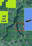
This is the twelfth scenery of the "VFR of Lario" project, made with
photorealistic terrain (multiseason & night) and with some 3D GMax realistic objects.
This scenery covers approximately an area of 7.5x6 kmt, from Limonta (NW) to the northern Grigna mountain (NE), from Onno (SW) to southern Grigna mountain (SE); some of specific buildings are included, as the small church and Museum of Cycling (Ghisallo), villa at pier (Limonta) and interruption of the freeway overpass (Mandello del Lario ... waiting for the next B3 scenery); are included five NLC piers (Limonta, Onno, Vassena, Lierna and Mandello del Lario) and two small motorboat (Ninfea and Giglio) of the NLC navigation; there are also included six sections of the freeway SS36 with its overpasses and tunnels. Some other minor boats and docks are placed alongside the lake coast.
Check video available here: http://youtu.be/q9I5B6oF4ZY
| Filename: | VFR_of_Lario_Area_C3__Como_lake_Italy.zip |
| License: | Freeware |
| Added: | 30th April 2013, 23:20:59 |
| Downloads: | 829 |
| Author: | Aldo Della Vedova, Daniele Lanfranchi, Gian Mario Verga |
| Size: | 22.95 MB |
| Category: Flight Simulator X - Utilities | |
| FCA - Flight Connection Analyzer |
|
Images related to this file:
File Description:
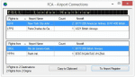
Flight Connection Analyzer is an easy and comfortable tool to extract and present data like airport visiting frequencies, connected airport pairs, and use of aircraft models and airlines from your flight record, either directly from the FSX logbook or from an external source.
| Filename: | FCA__Flight_Connection_Analyzer.zip |
| License: | Freeware |
| Added: | 5th November 2019, 17:31:38 |
| Downloads: | 107 |
| Author: | Mario Kassmann |
| Size: | 1.14 MB |
| Category: Miscellaneous Files - Miscellaneous Files | |
| British Airways + partners Winter Schedules 2008 - 2009 In Excel Format |
|
File Description:
British Airways + partners Winter Schedules In Excel Format
This small excel sheet shows the correct flight numbers,alpha numeric callsigns,aircraft types, departure and destinations for this winter schedules routes by BA, including positioning and maintenance flights
The data was painstakingly taken over a week from 1st Nov - 7th Nov from a variety of sources and is 99% accurate.
MS Excel needed and also no reproduction of data please without permission...
| Filename: | British_Airways__partners_Winter_Schedules_2008__2.zip |
| License: | Check within download |
| Added: | 8th November 2008, 00:13:40 |
| Downloads: | 331 |
| Author: | Pete King |
| Size: | 151.15 KB |
| Category: Flight Simulator 2004 - Scenery Design | |
| US Navy Swiftboat |
|
File Description:
FS2004/FS2002 API macro--US Navy Swiftboat
for scenery designers in two versions. one
with radar on and the other with it off.
This Vietnam era 50 foot long river and
coastal waterway boat had very powerful
engines and could outrun just about anything
on the water. With it's 50 caliber machine
gun and other weapons which sometimes included
a small mortar it was a fearsome weapon.
By Al Simms
| Filename: | US_Navy_Swiftboat.zip |
| License: | Freeware |
| Added: | 29th April 2006, 05:00:37 |
| Downloads: | 452 |
| Author: | Albert E Simms Jr |
| Size: | 524.46 KB |
| Category: Flight Simulator 2004 - AI Flight Plans | |
| Dniproavia (Ukraine) Winter 2007/2008 |
|
File Description:
Flightplans for Dniproavia - a small ukrainian carrier, whoes roots trace back as early as 1933. The modern Dniproavia started 1963 and was originally formed as Aeroflot's Dnepropetrovsk division. From its hub Dnepropetrovsk Dniproavia serves regional and international destinations on scheduled and chartered flights (Kiev, Odessa, Moskow Domodedovo (Russia), Warsaw (Poland), Vienna (Austria), Istanbul (Turkey), Hurghada and Sharm el Sheik (Egypt). Charterflights included. Tested with TTools (bgl-file included).
| Filename: | Dniproavia_Ukraine_Winter_20072008.zip |
| License: | Freeware |
| Added: | 16th December 2007, 13:54:27 |
| Downloads: | 1,479 |
| Author: | Uwe Hoffmann |
| Size: | 13.34 KB |
| Category: Flight Simulator 2004 - Gauges | |
| SuperOTTO (dual autopilot system) |
|
File Description:
2 fully independant autopilots in 1 box (for small and mid-size commercial jets like B737, B757, A320, A330), with features like auto-takeoff, anti-hijacking lock, emergency decompression descent, a variety of auto-systems (like wing-leveler programs, rudder-control and active yaw-damper programs, fast throttle-control with selectable max-percent N1, auto-flaps, auto-gear, auto-brakes, flight-plan navigation (both lateral and vertical)), and much more :)
| Filename: | SuperOTTO_dual_autopilot_system.zip |
| License: | Freeware |
| Added: | 2nd November 2005, 13:55:17 |
| Downloads: | 3,205 |
| Author: | Jacob Larsen |
| Size: | 1.41 MB |
| Category: Flight Simulator 2002 - AI Flight Plans | |
| TAME airlines of Ecuador AI Package |
|
File Description:
This is an AI package for the ecuadorian airline TAME.TAME is a small carrier operating a few A320s and B727s and one Fokker F-28 out of Quito to some national and a few international destinations across South America.this AI Package contains the FSP A320 in Tame colors (textures only!! you need the FSP airbus basepack), Flightplans and a TAME voicepack.you can also use this AI pack in FS 2004!! enjoy!!
| Filename: | TAME_airlines_of_Ecuador_AI_Package.zip |
| License: | Freeware |
| Added: | 10th August 2003, 23:20:12 |
| Downloads: | 1,339 |
| Author: | Martin Schuster / Sandro Frehner |
| Size: | 712.26 KB |
| Category: Flight Simulator 2002 - Scenery | |
| Aleutian Islands Scenery Enhancement - Part I |
|
File Description:
This scenery enhances the Aleutian Islands in Alaska. Over 80 small, individual
scenery areas have been added to the Aleutians to provide VFR landmarks while
flying this area with World Aeronautical Charts. (WAC)
All cabin and building markers from WAC charts CE-12 and CE-13 are present in
the scenery. It consists mostly of cabins which are spread out through the Aleutians.
Unalaska has been completely enhanced, adding the city, ships, and docks to the default airport. Some floatbases (not covered by Dave's scenery) in the Aleutians now have corresponding cabins and wood docks around them.
This scenery is fully compatible with Dave Erickson's "Alaskan Docks 2" scenery,
and is HIGHLY recommended, as I did not touch any of the areas which are covered by that scenery, except for Unalaska, for which I used a city map to recreate and upgrade. Details in the readme.
| Filename: | Aleutian_Islands_Scenery_Enhancement__Part_I.zip |
| License: | Freeware |
| Added: | 18th November 2002, 04:06:24 |
| Downloads: | 2,911 |
| Author: | Jorge 'eko' Salas |
| Size: | 6.13 MB |


© 2001-2026 AVSIM Online
All Rights Reserved
Privacy Policy |