
Where Flight Simulation Enthusiasts Gather from Around the World!
AVSIM Library - Search Results

| Category: Flight Simulator 2004 - Scenery | |
| Vance W. Amory International Airport, St Kitss and Nevis (TKPN), Version 1.0 |

|
Images related to this file:
File Description:
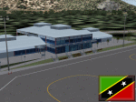
This zip-file contains a detailed yet very frame-rate friendly scenery for the Vance W. Amory International Airport, Newcastle, St. Kitts and Nevis. Version 1.0. Added as much photo-real details as possible. Limited night texture at this time. Included the "Hurricane Hill" so the approach of runway 10 becomes a bit challenging like in real-world. Charts included.
For the trees to show up around the airfield you need to have installed: Gerrish Gray's trees_v3.zip.
| Filename: | Vance_W_Amory_International_Airport_St_Kitss_and_N.zip |
| License: | Freeware, limited distribution |
| Added: | 22nd March 2010, 16:53:20 |
| Downloads: | 2,545 |
| Author: | Marcel Ritzema |
| Size: | 2.77 MB |
| Category: Flight Simulator 2002 - AFCAD Files | |
| Gates/Taxiways for Airport Teneriffe Reina Sofia and La Gomera (Canary Islands) |
|
File Description:
This AFCAD file adds all the Teneriffe's (GCTS) and La Gomera's (GCGM) Airport real gates and taxiways.
To use with the Teneriffe2003 scenery by Sim-Wings.
Teneriffe2003 by http://www.sim-wings.de and
AFCAD are needed.
| Filename: | GatesTaxiways_for_Airport_Teneriffe_Reina_Sofia_an.zip |
| License: | Freeware |
| Added: | 3rd October 2002, 00:37:23 |
| Downloads: | 873 |
| Author: | Juerg Bertschinger |
| Size: | 66.82 KB |
| Category: Fly! II - Scenery | |
| Palo Alto Airport of Santa Clara County and Sea Plane Base (KPAO) |
|
File Description:
TerraModels Scenery Development System by Allen Kriesman was used to create the scenery for Palo Alto Airport of Santa Clara County (KPAO), California. Biber Salsa models were also used to create this scenery. The taxiways were added by Pieter Miller. No custom models were created for this scenery.
| Filename: | Palo_Alto_Airport_of_Santa_Clara_County_and_Sea_Pl.zip |
| License: | Freeware |
| Added: | 28th December 2003, 02:02:26 |
| Downloads: | 127 |
| Author: | Wayne Roberts |
| Size: | 202.02 KB |
| Category: Flight Simulator 2002 - AFCAD Files | |
| WSSS - Singapore Changi International Airport Terminal 1 and Terminal 2 AFCAD file |
|
File Description:
This file is a 2 overlay for Changi International Airport Singapore.
The file "wsss2.txt" is for Terminal 1, and the file "2wss2.txt" is for Terminal 2.
All aircraft for Terminal 1 will be using runway 2L/20R, while for Terminal 2 they will use 2R/20L.
This is to avoid 'traffic-jams' on the ground if you happen to have a lot of AI airplanes.
I have also split the "GROUND" frequencies for the two terminal, so as to avoid congestion in the "GROUND" communication
frequency. In addition, this is to hopefully avoid the GROUND sending airplanes to the wrong side of the airport for parking.
The gates have been numbered according to real life (approximately).
| Filename: | WSSS__Singapore_Changi_International_Airport_Termi.zip |
| License: | Freeware |
| Added: | 2nd March 2003, 20:56:50 |
| Downloads: | 1,057 |
| Author: | George Hariman |
| Size: | 273.36 KB |
| Category: Flight Simulator 2002 - Scenery | |
| Phoenix Sky Harbor Intl. Airport with Landclass and Mesh for Phoenix Arizona. |
|
File Description:
This is Version 3.5 of my Phoenix airport and metro area scenery. Includes KPHX airport Landclass for Phoenix Arizona and 30m Mesh for the Phoenix Area. I do not take credit for the 30m mesh however I do not know how made it originally I include it here for it accuracy. Whoever made the Mesh ...Thank YOU it is awesome. I have also included AFCAD files for the KPHX airport.
| Filename: | Phoenix_Sky_Harbor_Intl_Airport_with_Landclass_and.zip |
| License: | Freeware |
| Added: | 29th January 2003, 21:17:42 |
| Downloads: | 4,881 |
| Author: | Rick |
| Size: | 4.14 MB |
| Category: Flight Simulator X - AFCAD Files | |
| CYDF - Deer Lake Regional Airport / Deer Lake, Newfoundland and Labrador, Canada (v1.1) |
|
Images related to this file:
File Description:
CYDF - Deer Lake Regional Airport / Deer Lake, Newfoundland and Labrador, Canada (v1.1)
This airport update was made with the latest version of ADE (Airport Design Editor) and made for FSX as a replacement for the stock (default) airport. I've made several changes to the airport which are listed below. All these enchancements are as close to the real airport as I can get with stock library objects. I've used satellite images, terminal photos and maps throughout the whole process so building locations are as accurate as possible. Happy landings in the beautiful Canada!
Features:
*Expanded parking apron
*Main terminal building with commercial aircraft parking
*Seperate parking aprons for GA traffic
*Hangars and other airport buildings
*Airport vehicles and objects throughout the airport
*Parking lot with static vehicles
*Airport fire station with fire truck
*De-icing vehicle/runway plow
*Helipads
*Fuel tanks
*Runway lengthened to 8,000ft as per recent upgrade (v1.1)
*Vehicle paths corrected (v1.1)
(For more information on Endeavourai please visit our site at endeavourai.com or our forums at http://endeavourai.boards.net/)
| Filename: | CYDF__Deer_Lake_Regional_Airport__Deer_Lake_Newfou.zip |
| License: | Freeware |
| Added: | 9th August 2012, 17:15:43 |
| Downloads: | 626 |
| Author: | Jaison Diaz / Endeavour ai |
| Size: | 66.97 KB |
| Category: Flight Simulator X - Scenery | |
| Winter Haven, FL Gilbert Airport (KGIF) and Jack Browns Seaplane School (F57) |
|
Images related to this file:
File Description:
Winter Haven's Gilbert Airport is somewhat unique in that it adjoins Jack Browns Seaplane School on Lake Jessie. The airport serves as a fly-in location for the nearby Lakeland Sun N' Fun airshow where camping is allowed under aircraft wings on the apron.
Scenery in this package is based on Virtual Earth (Bing) and Google Earth imagery. Gilbert Airport includes a new GA terminal and apron and is connected with a taxiway to Jack Browns Seaplane School. Ramps from the water to the apron at Jack Browns are also included. Landclass changes, roads, rework of taxiways and aprons, placement of library objects and a library of new airport buildings are included.
| Filename: | Winter_Haven_FL_Gilbert_Airport_KGIF_and_Jack_Brow.zip |
| License: | Freeware |
| Added: | 9th May 2010, 08:29:56 |
| Downloads: | 907 |
| Author: | Art Poole |
| Size: | 759.09 KB |
| Category: Prepar3D V1-4 - AFCAD Files | |
| QualityWings 787 Additional Airport Maps (over 100) for payware and freeware airports |
|
Images related to this file:
File Description:

QualityWings 787 Additional Airport Maps for over 100 payware and freeware airports including maps for airports such as Fly Tampa Amsterdam, Aerosoft's Heathrow, Orbx's Stockholm Arlanda plus many more!
| Filename: | QualityWings_787_Additional_Airport_Maps_over_100_.zip |
| License: | Freeware |
| Added: | 27th May 2018, 22:53:33 |
| Downloads: | 2,176 |
| Author: | Tom Bews and Mungo Spencer |
| Size: | 5.17 MB |
| Category: Prepar3D V1-4 - Scenery | |
| TNCB - Flamingo International Airport |
|
File Description:
Flamingo International Airport (IATA: BON, ICAO: TNCB), also called Bonaire International Airport, is an international airport located near Kralendijk on the island of Bonaire in the Caribbean Netherlands. It was the once the hub for BonaireExel and CuraçaoExel before they were rebranded as Dutch Antilles Express, and served as a secondary hub for Dutch Antilles Express and Insel Air. The airport is the fourth largest in the Dutch Caribbean, after Queen Beatrix International Airport on Aruba, Princess Juliana International Airport on Sint Maarten and Curaçao International Airport on Curaçao and is now the largest airport in the Caribbean Netherlands, with F. D. Roosevelt Airport in Sint Eustatius being the second largest and Juancho E. Yrausquin Airport in Saba being the smallest.
| Filename: | TNCB__Flamingo_International_Airport.zip |
| License: | Freeware |
| Added: | 3rd May 2021, 19:57:58 |
| Downloads: | 447 |
| Author: | Eduardo Puelker |
| Size: | 12.73 MB |
| Category: Flight Simulator 2004 - Scenery | |
| Havana 1962 Scenery |
|
File Description:
This scenery includes Havana as it was in 1962 (a mysterious city of much fascination for me) including El Morro Fortress on its rocky outcropping at the entrance to Havana harbor, the largest such fortress in the Caribbean, and its adjacent lighthouse. In downtown Havana you will see the capital building and several old cathedrals. Near the Malicon sea walk by the beach, you will find 3 famous hotels and former casinos, the Flamingo, the Riviera, and the Havana Hilton. The Havana Hilton opened just days before Castro seized power and nationalized it. When he first came to power he occupied the top floor for some time. Havana Airport opened originally as Rancho Los Boyeos Airport, located just southwest from the city in the village of the same name, which was then mostly farms, small ranches, and tiny communities. The original terminal was a very pretty Spanish colonial building, which the dictator Fulgencio Batista had remodeled in a 1950's cubist-tudor style. It was at the time of this remodeling (1957) that the airport's name was changed to Jose Marti International Airport, named after the famous Cuban revolutionary and poet of the 19th century. Jose Marti Airport was in the 1950s and 1960s the primary port of entry airport for Cuba. Up until the January 1st 1959 revolution many US airlines served Havana, but due to mounting tensions, the crisis of the Bay of Pigs attack, and later on the October 1962 missile crisis, traffic and tourism was ended as the US led blockade of Cuba took hold. By the time of this scenery, April 1962, the once former bustling Jose Marti airport had become quite sedate.
| Filename: | Havana_1962_Scenery.zip |
| License: | Freeware, limited distribution |
| Added: | 4th March 2010, 23:36:41 |
| Downloads: | 3,864 |
| Author: | Mike Stevens and Tom Gibson |
| Size: | 9.72 MB |
© 2001-2026 AVSIM Online
All Rights Reserved
Privacy Policy |