
Where Flight Simulation Enthusiasts Gather from Around the World!
AVSIM Library - Search Results

| Category: Flight Simulator 2004 - Scenery | |
| Kimmirut CYLC on Baffin Island in Nunavut, Canada |

|
Images related to this file:
File Description:
Kimmirut is a village of some 400 folks at the southern end of the southwest-facing coast of Baffin Island, 75 miles southwest of Iqaluit. It is on the northern side of the Hudson Strait between Baffin Island and Quebec, opposite Kangiqsujuaq on the Quebec shore. The airfield is served by two flights per week, one on Monday and another on Friday, only half fueled to be able to use the 1,899' of gravel 75' wide runway. The terminal building is small and there is a garage building for airport maintenance vehicles (snow clearing). There are some nearby buildings that I have included. The village is "represented" (not "modeled") with approximately the right shape and road layout. Take enough fuel so that you can leave again, as fuel is no longer for sale here. The Cape Dyer bgls are to make a small correction, it is explained in the text. I will not be posting new sceneries in the future and this is the last one for Avsim; it completes Baffin Island.
| Filename: | Kimmirut_CYLC_on_Baffin_Island_in_Nunavut_Canada.zip |
| License: | Freeware, limited distribution |
| Added: | 25th July 2011, 17:36:57 |
| Downloads: | 534 |
| Author: | Roger Wensley |
| Size: | 2.53 MB |
| Category: Flight Simulator 2004 - Miscellaneous Files | |
| EGNX East Midlands Airport Charts |
|
File Description:
Airport Charts for EGNX East Midlands Airport. Includes SID's, STAR's, Runway and Airport Diagrams.
| Filename: | EGNX_East_Midlands_Airport_Charts.zip |
| License: | Freeware |
| Added: | 10th October 2003, 23:40:09 |
| Downloads: | 1,332 |
| Author: | Matt Weddell |
| Size: | 1.04 MB |
| Category: Flight Simulator 2004 - Miscellaneous Files | |
| EGGW London Luton Airport Charts |
|
File Description:
Airport Charts for EGGW London Luton Airport. Includes SID's, STAR's, Runway and Airport Diagrams.
| Filename: | EGGW_London_Luton_Airport_Charts.zip |
| License: | Freeware |
| Added: | 11th October 2003, 02:09:45 |
| Downloads: | 1,656 |
| Author: | Matt Weddell |
| Size: | 724.99 KB |
| Category: Flight Simulator 2004 - Miscellaneous Files | |
| EGKK London Gatwick Airport Charts |
|
File Description:
Airport Charts for EGKK London Gatwick Airport. Includes SID's, STAR's, Runway and Airport Diagrams.
| Filename: | EGKK_London_Gatwick_Airport_Charts.zip |
| License: | Freeware |
| Added: | 11th October 2003, 02:10:15 |
| Downloads: | 2,534 |
| Author: | Matt Weddell |
| Size: | 1.13 MB |
| Category: Flight Simulator 2004 - Miscellaneous Files | |
| EGLC London City Airport Charts |
|
File Description:
Airport Charts for EGLC London City Airport. Includes SID's, STAR's, Runway and Airport Diagrams.
| Filename: | EGLC_London_City_Airport_Charts.zip |
| License: | Freeware |
| Added: | 11th October 2003, 02:10:27 |
| Downloads: | 1,936 |
| Author: | Matt Weddell |
| Size: | 638.44 KB |
| Category: Flight Simulator X - Scenery | |
| RAF Balderton |
|
File Description:
RAF Balderton is a former Royal Air Force station located 2.0 miles (3.2 km) south of Newark-on-Trent, sandwiched between the now extinct Great Northern Railway (GNR) Bottesford-Newark line and the A1 road in Nottinghamshire, England.
Opened in 1942, it was used by both the Royal Air Force and United States Army Air Forces. During the war it was used primarily as a troop carrier transport airfield and after for munitions storage before it was closed in 1957.
With the facility released from military control, Balderton was returned to agriculture, the runway concrete disappearing as hardcore under the AI road improvements of the 1960s. At that time, the developed Al was routed west of the original road, over the eastern perimeter track of the airfield, before coming back to the east to bypass Balderton village and Newark.
Gypsum open-pit mining has also taken its toll where quarrying has completely obliterated the airfield, with single track roads all that remain of the runway and perimeter track, and the occasional concrete runway end or pile of rubble.
Today the remains of the airfield are located on private property being used as agricultural fields.
| Filename: | RAF_Balderton.zip |
| License: | Freeware |
| Added: | 17th February 2016, 23:32:44 |
| Downloads: | 233 |
| Author: | Terry Boissel |
| Size: | 759.04 KB |
| Category: Flight Simulator 2004 - Scenery | |
| KPMD - Palmdale AF Plant 42 |
|
Images related to this file:
File Description:

FS2004 Scenery for KPMD Palmdale AF A huge 5,800 acres/23 km² airfield that has somehow been overlooked by addon developers. almost all hangers and buildings are custom built due to their uniqueness to KPMD. Most of the facilities are owned by private contractors and serve as a manufacturing plant
for aircraft used by the United States .Rockwell's Palmdale assembly facility is where Space Shuttle came together
and were assembled and tested. Upon completion, the Shuttles were turned over to NASA for transport overland
to Edwards Air Force Base, California.
The airfield was opened in the early 1930s.At the outbreak of the Korean War in 1950, the U.S. Air Force realized a need
for a location for use in final assembly and flight testing of military jet aircraft, away from major population centers but close enough to the major
centers of aircraft design and production .Year round excellent flying weather was also a prerequisite. The land which
became AF Plant 42 fit all these criteria. Therefore the USAF bought the facility in in 1951.In the 1960's Lockheed
relocated to Plant 42 from its original Burbank, Ca .
| Filename: | KPMD__Palmdale_AF_Plant_42.zip |
| License: | Freeware |
| Added: | 29th January 2015, 21:22:39 |
| Downloads: | 825 |
| Author: | Brian Sturrock |
| Size: | 1.43 MB |
| Category: Prepar3D V1-4 - AI Aircraft | |
| AI Aviacsa AIG McDonnell Douglas DC-9-15 Last Livery Fleet Pack |
|
Images related to this file:
File Description:
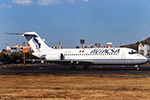
This is the pack of an extinct mexican airline of Aviacsa the McDonnell Douglas DC-9-15. The registrations are: XA-TIM, XA-TIZ, XA-TJS. Consorcio Aviacsa S.A. de C.V, doing business as Aviacsa, was a low-cost airline of Mexico, founded in 1990. The airline operated domestic services until the airline's grounding in 2011, radiating from major hubs at Monterrey, Mexico City and Guadalajara, and international service to Las Vegas in the United States. According to Mexico's Secretary of Communications and Transportation, as of September 2008, Aviacsa ranked as the seventh-largest Mexican airline in domestic and international flights, down from the third-largest at the end of 2007. In June and July 2009, the Mexican government repeatedly suspended Aviacsa's operations due to safety issues and unpaid fees. Aviacsa ceased operations on May 4, 2011. This is my website: https://el-mundo-de-los-aviones-ai-traffic.jimdosite.com The models of this traffic are Alpha India Group (AIG) McDonnell Douglas DC-9-10. I hope you enjoy it!
| Filename: | AI_Aviacsa_AIG_McDonnell_Douglas_DC915_Last_Livery.zip |
| License: | Freeware |
| Added: | 7th September 2025, 16:10:49 |
| Downloads: | 14 |
| Author: | Jesus Gibran Soriano Solleiro |
| Size: | 30.68 MB |
| Category: Prepar3D V1-4 - Scenery | |
| Occhito Dam Foggia Italy N41.37.09 E14.58.25 |
|
Images related to this file:
File Description:
Occhito Dam Foggia Italy N41.37.09 E14.58.25 Born from the Fortore River barrage, Occhito dam originates from the second largest artificial water mirror in Italy. The dam rises in the territory of Carlantino, one of the small villages in the province of Foggia on the border with Molise, and was built at the end of the 1950s to meet the water needs of the province.
Important VFR point for approaching airport Foggia Gino Lisa.
Within the downloaded package you will find readme files for scenery installation. Good fly VFR. Pasquale Marrulli.
| Filename: | Occhito_Dam_Foggia_Italy_N413709_E145825.zip |
| License: | Freeware |
| Added: | 14th November 2017, 16:44:52 |
| Downloads: | 301 |
| Author: | Pasquale Marrulli |
| Size: | 1.47 KB |
| Category: Prepar3D V1-4 - Scenery | |
| Valdez Alaska USA N61.06.53 W146.19.52 and Tatitlek Alaska USA N6052.00 W146.41.37 |
|
File Description:
Valdez Alaska USA N61.06.53 W146.19.52 The town is positioned at the head of a fjord on the eastern side of the Prince William Strait (at the end of the Valdez bay). It is surrounded by the Chugach mountains with many glaciers and peaks up to 2100 m above sea level. Although the northernmost port in North America is free of ice all year round. It is also the northernmost point of the Pacific coastal forest located in the 107-meter hill southwest of the town called Blueberry Hill. Valdez has an ICAO PAVD airport that in the scenario in addition to the city of Valdez you will also find a small village called Tatitlek Alaska USA N6052.00 W146.41.37 with related ICAO 7KA airport airports infrastructures have been improved with the addition of a port for landing ships and seaplanes on Valdez and Tatitlek. Important VFR point for approaching airport and seairport PAVD and 7KA.
Within the downloaded package you will find readme files for scenery installation. Good fly VFR. Pasquale Marrulli.
| Filename: | Valdez_Alaska_USA_N610653_W1461952_and_Tatitlek_Al.zip |
| License: | Freeware |
| Added: | 21st May 2018, 22:35:56 |
| Downloads: | 230 |
| Author: | Pasquale Marrulli |
| Size: | 3.27 MB |
© 2001-2026 AVSIM Online
All Rights Reserved
Privacy Policy |