
Where Flight Simulation Enthusiasts Gather from Around the World!
AVSIM Library - Search Results

| Category: Flight Simulator X - Scenery | |
| SBBE Val de Cans and SBMQ Macapa International - Brazil |

|
Images related to this file:
File Description:
SBBE Val de Cans-Julio Cezar Ribeiro International Airport - Belem , also includes SBMQ Macapa International - Macapa - Brazil - improvements to the default airports.
| Filename: | SBBE_Val_de_Cans_and_SBMQ_Macapa_International__Br.zip |
| License: | Freeware, limited distribution |
| Added: | 13th January 2013, 19:30:52 |
| Downloads: | 5,586 |
| Author: | Roberto Zanolli |
| Size: | 1.14 MB |
| Category: Flight Simulator X - Aircraft Repaints, Textures and Modifications | |
| jetBlue a220 Pack, Three tails, Bubbles, Barcode and Vacation |
|
Images related to this file:
File Description:

Included 3 jetBlue liveries for the Virtualcol a220 payware model.
Bubbles (A321 Neo Tail)
Barcode
Vacation
Textures Only, Requires Model
https://secure.simmarket.com/virtualcol-airbus-a220-series-pack-fsxp3d.phtml
| Filename: | jetBlue_a220_Pack_Three_tails_Bubbles_Barcode_and_.zip |
| License: | Freeware |
| Added: | 20th April 2019, 04:58:36 |
| Downloads: | 470 |
| Author: | VirtualCol, Painted by Michael Ullman |
| Size: | 10.8 MB |
| Category: Flight Simulator 2004 - Scenery | |
| "Himalayan Peaks" LOD10 Mesh, Volume 7 - K2 and Karakoram |
|
Images related to this file:
File Description:
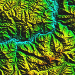
Highly detailed terrain mesh of the Karakoram area, N35-37 E73-77. The files in this package are based on Shuttle Radar (SRTM) Version 2 data but with many of the void areas, especially the most significant sections, filled with elevation data generated from topographic maps by Jonathan de Ferranti. While Jonathan's work is unrelated to flight simulation he kindly gave me permission to compile his data for use in FS. The result is a wonderful improvement in detail and accuracy over any existing mesh file, freeware or commercial, based on SRTM or DTED data alone.
Due to the large area of the Himalayas I've compiled the source data as two separate series: the "Himalayan Peaks" series covers prominent mountains and ranges in higher detail and locally overrides any existing LOD9 terrain mesh. In addition, a LOD9 "base mesh" series covering the entire Himalayas will be available for those who do not yet have an add-on terrain mesh of these beautiful mountains.
| Filename: | Himalayan_Peaks_LOD10_Mesh_Volume_7__K2_and_Karako.zip |
| License: | Freeware, limited distribution |
| Added: | 30th May 2010, 09:56:27 |
| Downloads: | 9,490 |
| Author: | Holger Sandmann, Jonathan de Ferranti |
| Size: | 38.58 MB |
| Category: Flight Simulator 2004 - Scenery | |
| Himalayas LOD9 Base Mesh, Volume 4 - Kashmir and Jammu |
|
File Description:
Detailed terrain mesh of the Kashmir and Jammu Ranges, N30-39 E76-78. The files in this package are based on Shuttle Radar (SRTM) Version 2 data but with many of the void areas, especially the most significant sections, filled with elevation data generated from topographic maps by Jonathan de Ferranti. While Jonathan's work is unrelated to flight simulation he kindly gave me permission to compile his data for use in FS. The result is a wonderful improvement in detail and accuracy over any existing mesh file, freeware or commercial, based on SRTM or DTED data alone.
Due to the large area of the Himalayas I've compiled the source data as two separate series: the "Himalayan Peaks" series covers prominent mountains and ranges in higher detail and locally overrides any existing LOD9 terrain mesh. In addition, the LOD9 "base mesh" series, with LOD8 and LOD7 "buffer" mesh files, covering the entire Himalayas, is meant for those who do not yet have an add-on terrain mesh of these beautiful mountains.
| Filename: | Himalayas_LOD9_Base_Mesh_Volume_4__Kashmir_and_Jam.zip |
| License: | Freeware, limited distribution |
| Added: | 22nd February 2006, 20:32:50 |
| Downloads: | 7,511 |
| Author: | Holger Sandmann, Jonathan de Ferranti |
| Size: | 29.24 MB |
| Category: Flight Simulator 2004 - Scenery | |
| "Himalayan Peaks" LOD10 Mesh, Volume 6 - Jammu and Kashmir |
|
Images related to this file:
File Description:
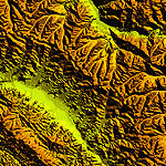
Highly detailed terrain mesh of the Jammu and Kashmir areas, N31-36 E76-78. The files in this package are based on Shuttle Radar (SRTM) Version 2 data but with many of the void areas, especially the most significant sections, filled with elevation data generated from topographic maps by Jonathan de Ferranti. While Jonathan's work is unrelated to flight simulation he kindly gave me permission to compile his data for use in FS. The result is a wonderful improvement in detail and accuracy over any existing mesh file, freeware or commercial, based on SRTM or DTED data alone.
Due to the large area of the Himalayas I've compiled the source data as two separate series: the "Himalayan Peaks" series covers prominent mountains and ranges in higher detail and locally overrides any existing LOD9 terrain mesh. In addition, a LOD9 "base mesh" series covering the entire Himalayas will be available for those who do not yet have an add-on terrain mesh of these beautiful mountains.
| Filename: | Himalayan_Peaks_LOD10_Mesh_Volume_6__Jammu_and_Kas.zip |
| License: | Freeware, limited distribution |
| Added: | 29th May 2010, 08:55:43 |
| Downloads: | 9,677 |
| Author: | Holger Sandmann, Jonathan de Ferranti |
| Size: | 52.19 MB |
| Category: Flight Simulator X - Scenery | |
| St. Kitts Island - Federation of Saint Kitts and Nevis |
|
Images related to this file:
File Description:
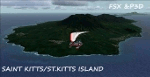
A representation of St. Kitts using photo-real scenery along with hand placed autogen. Robert L. Bradshaw International Airport is an international airport located just northeast of Basseterre, on the island of Saint Kitts, serving the nation of Saint Kitts and Nevis.
New construction started late 2004. Up to 6 wide bodied jets can now be accommodated on the tarmac. The airport can accommodate commercial jumbo jets and handles scheduled non-stop jet flights to Canada and the United States, as well as numerous regional commuter flights from within the Caribbean area. For the best results of this scenery, PWSceneries Volume 5 has to be installed. Features included are custom photo scenery covering the entire island, hand placed autogen, detailed 3D Objects and custom buildings. Works in FSX and P3D.
| Filename: | St_Kitts_Island___Federation_of_Saint_Kitts_and_Ne.zip |
| License: | Freeware |
| Added: | 24th September 2015, 10:57:42 |
| Downloads: | 834 |
| Author: | Kenje Thomas & Jamalje Bassue |
| Size: | 105.56 MB |
| Category: Miscellaneous Files - Demos from Commercial Vendors | |
| TOPCAT 2.35 - Take-Off and Landing Performance Calculation Tool |
|
File Description:
TOPCAT is an acronym for Take-Off and Landing Performance Calculation Tool. It's a highly realistic, easy-to-use planning tool for all serious flight simulator enthusiasts. It brings into a single application all of the calculations required to plan for safe and repeatable take-offs and landings including de-rated thrust and assumed temperature calculation. Currently the follwing airplane types are available in TOPCAT (more to come): Boeing 747-400, Boeing 747-400 Freighter, Boeing 747-400, Boeing 767-300, Boeing 767-300 ER, Boeing 767-300 Freighter and the Airbus A320-214. Now compatible with PMDG 747(F), LDS 767-300 and Wilco/Feelthere Load Managers. NOTE: This is an unlimited, fully functional demo version. Win32 installer package including uninstall function. Take your simulation to the next level!
| Filename: | TOPCAT_235__TakeOff_and_Landing_Performance_Calcul.zip |
| License: | Commercial demo |
| Added: | 30th September 2008, 10:27:42 |
| Downloads: | 1,643 |
| Author: | Judith Blaschegg & Christian Grill |
| Size: | 4.23 MB |
| Category: Flight Simulator X - Aircraft Repaints, Textures and Modifications | |
| Harbor Air Taxi "red and white" Cessna C206 (N8755F) |
|
Images related to this file:
File Description:
Red and white Cessna 206 N8755F Harbor Air Taxi textures.
For the payware Carenado Cessna 206. Repaint by Tom Tiedman.
| Filename: | Harbor_Air_Taxi_red_and_white_Cessna_C206_N8755F.zip |
| License: | Freeware |
| Added: | 6th February 2016, 16:38:58 |
| Downloads: | 107 |
| Author: | Tom Tiedman / Carenado |
| Size: | 24.24 MB |
| Category: Flight Simulator X - Scenery | |
| California Central Coast with Megascenery Earth and FSGenesis Mesh |
|
Images related to this file:
File Description:
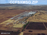
California Central Coast Scenery for FSX with Megascenery Earth and FSGenesis mesh. CCFSXMSG.ZIP covers the California coastal region from N36° 10' (Coalinga) to N34° 25' (Santa Barbara) and from the coast East to W119° 40'. It is a version of my previously created California Central Coast scenery redesigned and expanded to work with FSX MegaScenery Earth and FSGenesis USA Terrain Mesh for FSX V2 by Justin Tyme. Airstrips in the area covered by this scenery have been added for a total of 27 airports and airstrips. 6 imaginary water runways are also added for AI float plane traffic. Several other areas of interest such as the Santa Barbara marina, Morro Bay, etc. are included for a total of 41 points of interest. All airports, airstrips and related structures have been adjusted and realigned to conform to actual positions and dimensions as indicated by the MegaScenery Earth satellite textures. Megascenery Earth California-13, -14 and -15 are required and -12, -28 and -29 are recommended. By Al Wheeler 9/25/09.
| Filename: | California_Central_Coast_with_Megascenery_Earth_an.zip |
| License: | Freeware |
| Added: | 7th January 2010, 19:54:57 |
| Downloads: | 874 |
| Author: | Al Wheeler |
| Size: | 8.13 MB |
| Category: Flight Simulator 2004 - Scenery | |
| Middle East SRTM Mesh - Lebanon, Israel and Egypt Part2 |
|
File Description:
Middle East SRTM Mesh - Lebanon, Israel and most of Egypt LOD9 Terrain Mesh in 3 parts, created from SRTM 3arc sec spatial data - this is Part 2. Mesh covers area from N25 - N34 and E29 - E36. It gives You possibility to fly above continuous terrain of Lebanon, Israel and Egypt. Holes were cleared using SRTM/DTED0 merger by Martin Domig, MICRODEM and SRTMFill.
| Filename: | Middle_East_SRTM_Mesh__Lebanon_Israel_and_Egypt_Pa.zip |
| License: | Freeware, limited distribution |
| Added: | 23rd April 2004, 12:55:58 |
| Downloads: | 6,649 |
| Author: | Ryszard Winawer |
| Size: | 21.07 MB |


© 2001-2026 AVSIM Online
All Rights Reserved
Privacy Policy |