
Where Flight Simulation Enthusiasts Gather from Around the World!
AVSIM Library - Search Results

| Category: Flight Simulator X - Scenery | |
| FSX Scenery Island of Saba |

|
File Description:
Scenery of Saba Island
Redisign of all coasts and land class
SABA airport
Citys : The Bottom, St John's, Windwardside, Hell's Gate
Harbour : Fort Bay
Roads and traffic adjust with land class
| Filename: | FSX_Scenery_Island_of_Saba.zip |
| License: | Freeware |
| Added: | 3rd October 2008, 01:27:15 |
| Downloads: | 5,721 |
| Author: | Valladier Jean louis |
| Size: | 1.62 MB |
| Category: Flight Simulator 2004 - Scenery | |
| Denver (KDEN), Colorado, Photo-Scenery |
|
Images related to this file:
File Description:

Denver (KDEN), Colorado, Photo-Scenery for FS9 & FSX.
This package covers Denver, the capital of Colorado which is also nicknamed Mile-High City because its elevation is one mile (5.280 ft). The sixth RW (16R/34L) of Denver Int'l. Airport (KDEN) is the longest commercial RW in the US with a length of 16.000ft. This allows fully loaded B747's to take off in Denvers mile-high altitude during hot summer days, when density altitudes can approach 9.000(!) ft.
KDEN is a major hub for United Airlines and the headquarters for Frontier Airlines. The airports distinctive white tent-like fabric roof is designed to be reminiscent of the snow-covered peaks of the Rocky Mountains which you can see on approach or departure.
Other important airports covered by this region are Centennial Airport (KAPA), Buckley AFB (KBKF) and Rocky Mountain Metropolitan Airport (KBJC). Extends my Mt.Evans/Georgetown package to the east and provides another 3.500 sq km in 4.7m/pix quality.
High resolution versions for FS9 and FSX (much sharper, but larger and multiple downloads) are available at www.blueskyscenery.com/GNB_SouthEast.html
. The screenies are taken from the high-res versions, so expect this version to be slightly more blurry. YourDonation@Work: Dedicated to Mark and Charles. Thanks!
| Filename: | Denver_KDEN_Colorado_PhotoScenery.zip |
| License: | Freeware, limited distribution |
| Added: | 31st October 2009, 11:24:39 |
| Downloads: | 7,276 |
| Author: | Gottfried Razek, blueskyscenery.com |
| Size: | 95.21 MB |
| Category: Flight Simulator 2004 - Scenery | |
| Australia Rockhampton New Scenery 2003 |
|
File Description:
New scenery about Rockhampton Australia with AFCAD file
| Filename: | Australia_Rockhampton_New_Scenery_2003.zip |
| License: | Freeware |
| Added: | 21st May 2010, 03:10:40 |
| Downloads: | 626 |
| Author: | Claude Schmidt |
| Size: | 2.15 MB |
| Category: Flight Simulator 2004 - Scenery | |
| FS2004 Scenery - Elizabeth Field 0B8 |
|
File Description:
FS2004 Scenery - Elizabeth Field Airport (0B8) serves Fishers Island and Suffolk County Long Island, N.Y. and is owned by Town Of Southold. The airport has more than one runway. The longest is a paved runway extending 2328 feet. The facility is at an elevation of 9 feet. The scenery objects were placed using Instant Scenery using the EZ Scenery libraries. Instructions for Ultimate Terrain users included. Created in collaboration with Ray Lunning by John B. Loney, Jr.
| Filename: | FS2004_Scenery__Elizabeth_Field_0B8.zip |
| License: | Freeware, limited distribution |
| Added: | 21st December 2007, 04:36:10 |
| Downloads: | 815 |
| Author: | John B. Loney, Jr. |
| Size: | 219.35 KB |
| Category: Flight Simulator X - Scenery | |
| Updated OETF Taif regional scenery |
|
File Description:
Update for default OETF scenery, add missing ILS runway 25, and correct runway headings.
| Filename: | Updated_OETF_Taif_regional_scenery.zip |
| License: | Check within download |
| Added: | 17th November 2016, 16:52:36 |
| Downloads: | 257 |
| Author: | Abdullah Radwan |
| Size: | 9.88 KB |
| Category: Flight Simulator 2004 - Scenery | |
| Australia missing airports database scenery |
|
File Description:
There are 5 missing airports missing in FS2004 database. I created 5 airports which are used in the Alliance Airlines flight plans.
| Filename: | Australia_missing_airports_database_scenery.zip |
| License: | Freeware |
| Added: | 14th March 2014, 17:21:09 |
| Downloads: | 273 |
| Author: | Stuart J Gilbert II |
| Size: | 4.51 MB |
| Category: Flight Simulator 2004 - Scenery | |
| Reading Regional Airport/MAAM Scenery |
|
File Description:
This package includes fully detailed scenery of the Reading Regional Airport (KRDG) in Reading, Pennsylvania, USA including the grounds of the Mid Atlantic Air Museum. All objects were constructed in Gmax and feature photo-realistic textures that bring them very close in appearance with their real-world counterparts. Scenery features include radio frequency-controlled hangar door animations, realistic AI GA and Commercial traffic and even the inclusion of an important local VFR landmark.
| Filename: | Reading_Regional_AirportMAAM_Scenery.zip |
| License: | Freeware, limited distribution |
| Added: | 24th December 2003, 20:02:01 |
| Downloads: | 15,789 |
| Author: | Bill Womack, Kenneth Weik, Charles Dayhuff and Tony Fosler |
| Size: | 10.6 MB |
| Category: Flight Simulator 2004 - AFCAD Files | |
| Genova (LIMJ) Scenery ISD LIMJ |
|
Images related to this file:
File Description:

AFCAD2 for Genova (LIMJ) Scenery ISD LIMJ, modified from Limjvirtual.it
--------------------------------------------------------------------
Reworked using, in the order:
1 - Airport related chart
2 - Scenery parking spaces available on the scenery itself and not covered by signed a/c parking.
http://www.genixsoft.com
| Filename: | Genova_LIMJ_Scenery_ISD_LIMJ.zip |
| License: | Freeware |
| Added: | 6th February 2011, 01:56:42 |
| Downloads: | 816 |
| Author: | Vincenzo Mercolino |
| Size: | 4.81 KB |
| Category: Flight Simulator 2004 - Scenery | |
| GERMANY 2004 SRTM MESH SCENERY |
|
File Description:
Based on SRTM 3 arc.sec data.
Unfortunately SRTM DATA have many holes and data loss, so I made a resampling and an oversampling with other data with lower resolution, but with better coverege (like data from swiss topographic federal istitute or from italian IGM, and finally with DTED Level 0.) with geo cad software like Grass and GlobalMapper for projection convertion.
Compression and conversion to bgl with MS Flight simulator SDK at LOD 9
This scenery cover the entire Germany teritory, the part of Swiss and Austria territories not included in my Italian scenery. Parts of Belgium and Netherlands and Luxembourg are included too (Till E005); next quite the whole territory of Czech Republic and part of Poland till E017.
| Filename: | GERMANY_2004_SRTM_MESH_SCENERY.zip |
| License: | Freeware |
| Added: | 23rd November 2003, 23:18:46 |
| Downloads: | 25,895 |
| Author: | Pietro Mauri |
| Size: | 62.08 MB |
| Category: Flight Simulator X - Scenery | |
| Algiers City PhotoTerrain Scenery X |
|
Images related to this file:
File Description:
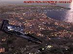
FSX Algiers City Photo Terrain by Riad GHENIM
Algiers City, DAAG, Algeria. A mediterranean city with its beautiful coasts. Beta version.
This photo terrain scenery works with Algiers Real Scenery DAAG for FSX
| Filename: | Algiers_City_PhotoTerrain_Scenery_X.zip |
| License: | Freeware |
| Added: | 3rd June 2011, 22:28:46 |
| Downloads: | 13,016 |
| Author: | Riad Ghenim |
| Size: | 25.34 MB |
© 2001-2026 AVSIM Online
All Rights Reserved
Privacy Policy |