
Where Flight Simulation Enthusiasts Gather from Around the World!
AVSIM Library - Search Results

| Category: Fly! II - Scenery | |
| Kaneohe Bay Marine Corps Airfield (PHNG) |

|
File Description:
TerraModels Scenery Development System by Allen Kriesman was used to create the scenery for Kaneohe Bay Marine Corps Airfield (PHNG), Hawaii. The airport is owned by the U. S. Navy. The FlyII designator for this airport is NGF. The taxiways were added using the program by Peter Jacobson. No custom models were created for this scenery.
| Filename: | Kaneohe_Bay_Marine_Corps_Airfield_PHNG.zip |
| License: | Freeware |
| Added: | 19th October 2003, 04:55:13 |
| Downloads: | 144 |
| Author: | Wayne Roberts |
| Size: | 211.79 KB |
| Category: Flight Simulator 2004 - Scenery | |
| Update to Snowed In Bed & Breakfast - for default mesh users |
|
File Description:
Snowed INN Bed and Breakfast - This is an Update to allow this scenery to display properly if you are using the default FS scenery without any Alaskan Mesh. Includes a revised Lago file and a flatten statement to add to your scenery entry. Requires installation of snowed_inn_bed_&_breakfast.zip. Author: Mike Woolsey with minor revisions by David "Opa" Marshall.
| Filename: | Update_to_Snowed_In_Bed__Breakfast__for_default_me.zip |
| License: | Freeware |
| Added: | 8th December 2005, 22:59:49 |
| Downloads: | 1,175 |
| Author: | David Marshall - Mike Woolsey |
| Size: | 2.33 KB |
| Category: Flight Simulator 2004 - Scenery | |
| DBWsim San Rafael 2005 |
|
File Description:
DBWsim proudly reopens Hamilton AFB in the northern San Francisco Bay Area. Included as well is scenery for the small local airfield of San Rafael. Both airports have been comprehensively redeveloped and the scenery features an improved local landclass.
VERSION 1.1
Major Content inclusion error fixed, the primary scenery for Hamilton AFB is now included in the pack.
| Filename: | DBWsim_San_Rafael_2005.zip |
| License: | Freeware |
| Added: | 28th September 2005, 13:02:06 |
| Downloads: | 3,166 |
| Author: | Derek and Brendan Webb |
| Size: | 1.59 MB |
| Category: Flight Simulator X - Scenery | |
| RAF Davidstow Moor 1945 |
|
File Description:
RAF Davidstow Moor 1945 for FSX. Blended to fit Horizon Scenery and Mesh.
This version contains full runways and dispersal points as in use in the late 1940's. Scenery items from various authors associated with the Runway 12 project have been used to enhance the scenery. Details of the extra files required are included in the readme.
| Filename: | RAF_Davidstow_Moor_1945.zip |
| License: | Freeware, limited distribution |
| Added: | 5th December 2007, 17:58:56 |
| Downloads: | 493 |
| Author: | Tony Meredith |
| Size: | 1.3 MB |
| Category: Flight Simulator X - Scenery | |
| Davidstow Moor 2007 |
|
File Description:
Davidstow Moor 2007 for FSX. Blended to fit Horizon Scenery and Mesh.
This version contains limited runways suitable only for Microlights and small aircraft and no dispersal points. Scenery items from various authors associated with the Runway 12 project have been used to enhance the scenery. Details of the extra files required are included in the readme.
| Filename: | Davidstow_Moor_2007.zip |
| License: | Freeware, limited distribution |
| Added: | 5th December 2007, 17:59:19 |
| Downloads: | 731 |
| Author: | Tony Meredith |
| Size: | 1.29 MB |
| Category: Flight Simulator 2004 - Scenery | |
| St Charles County (Smartt) |
|
File Description:
FS2004 Scenery - St Charles County (Smartt Field) KSET is a public owned airport lovated in St Charles, MO, USA. The airport has two asphalt runways 9/27 running 2000 ft and 18/36 running 3800 ft. This is a companion scenery for my recently released St Charles Municipal (3sq_v1.zip). Created with Instant Scenery. By John B. Loney, Jr.
| Filename: | St_Charles_County_Smartt.zip |
| License: | Freeware, limited distribution |
| Added: | 3rd April 2009, 18:57:54 |
| Downloads: | 388 |
| Author: | John B. Loney, Jr. |
| Size: | 6.4 MB |
| Category: Flight Simulator 2004 - Scenery | |
| CTH3 Canada, Quebec, Les Grandes-Bergeronnes |
|
Images related to this file:
File Description:
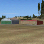
This is the scenery Les Grandes Bergeronnes (CTH3), which represents the reality. Les Grandes Bergeronnes is a small village located on Northern bank of the St-Laurent river of Quebec at Canada. This scenery is designed with FSDS and it accepts Mesh of Gilles Gauthier. This scenery functions for both FS-2004 and FS-X.
| Filename: | CTH3_Canada_Quebec_Les_GrandesBergeronnes.zip |
| License: | Freeware |
| Added: | 2nd January 2010, 19:29:43 |
| Downloads: | 374 |
| Author: | Regis Dassylva |
| Size: | 2.32 MB |
| Category: Flight Simulator 2004 - Scenery Design | |
| Woody's EZ Stuff2 |
|
File Description:
this is a EZ-scenery library that has some more stuff that you can use to dress up your scenery. It will add to the stuff that I had in my woody's EZ-stuff file earlyer on. You will also have to have it to use with some of the scenery that is being made for Tongass.
| Filename: | Woodys_EZ_Stuff2.zip |
| License: | Freeware, limited distribution |
| Added: | 2nd September 2006, 04:42:59 |
| Downloads: | 2,235 |
| Author: | Glenn "Woody" Fout |
| Size: | 310.07 KB |
| Category: Prepar3D V1-4 - Scenery | |
| Trump Turnberry |
|
Images related to this file:
File Description:
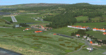
Prepar3D Scenery--X6TU Trump Turnberry, Scotland, UK. A detailed version of the Trump Turnberry site, including golf courses, hotel (with helipad) and remains of RAF Turnberry. Requires ORBX EU Scotland scenery. Works with FSX, FSX Steam or Prepar3D. Works with or without Scotflight for ORBX. Auto-installing freeware by Scotflight Scenery (Iain Gallacher and Iain Murray).
| Filename: | Trump_Turnberry.zip |
| License: | Freeware |
| Added: | 7th April 2017, 18:38:52 |
| Downloads: | 287 |
| Author: | Scotflight (Iain Gallacher & Iain Murray) |
| Size: | 36.64 MB |
| Category: Flight Simulator 2004 - Scenery | |
| Enna and Madonie mountains, Sicily, Italy, Photo Real |
|
Images related to this file:
File Description:
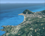
The photoreal scenery covers a great area of Sicily around the city of Enna and to the mountains of the Madonies. The Photo Real Scenery is wide for around 3200 squared Kms. The airport of Palermo (ICAO code LICJ) is found near to the scenery (see map). Otherwise the airport of Catania (ICAO code LICC) can be used.
| Filename: | Enna_and_Madonie_mountains_Sicily_Italy_Photo_Real.zip |
| License: | Freeware |
| Added: | 31st May 2010, 17:39:47 |
| Downloads: | 9,466 |
| Author: | Fulvio Mazzokan |
| Size: | 94.49 MB |
© 2001-2026 AVSIM Online
All Rights Reserved
Privacy Policy |