
Where Flight Simulation Enthusiasts Gather from Around the World!
AVSIM Library - Search Results

| Category: Flight Simulator 2004 - Scenery Design | |
| The Warehouse Collection: Airport Vehicles FS9 scenery objects |

|
Images related to this file:
File Description:
Some typical airport vehicles downloaded from the Google 3-D Warehouse and converted for use as FS9 scenery objects. I made olive drab versions of most of them for use at military facilities. Please read Google_3-D_Warehouse.pdf for more information, and warehouse_airport_vehicles_authors.pdf for author credits.
| Filename: | The_Warehouse_Collection_Airport_Vehicles_FS9_scen.zip |
| License: | Freeware |
| Added: | 31st October 2011, 08:30:59 |
| Downloads: | 1,942 |
| Author: | Sidney Schwartz & various authors |
| Size: | 14.16 MB |
| Category: Flight Simulator 2004 - Scenery | |
| 1963 La Paz Bolivia El Alto Airport Scenery |
|
File Description:
El Alto International Airport (IATA: LPB, ICAO: SLLP) is an international airport located in El Alto, near the city of La Paz, Bolivia; it serves national and international air traffic. At an altitude of 13,325 ft (4,061 m), it is one of the highest international airports in the world. The facility served as a focus city for the former Lloyd Aereo Boliviano, Bolivia's national air carrier, and is a hub for Aerosur, the country's only significant private airline. This scenery takes El Alto back to circa 1963, and with AI traffic from www.calclassic.com will be populated with everything from C-46 meat haulers to C-124 Globemasters. GMAX terminal by Jaap de Baare, local landclass by Tom Gibson, and almost everything else by Harry Biard.
| Filename: | 1963_La_Paz_Bolivia_El_Alto_Airport_Scenery.zip |
| License: | Freeware, limited distribution |
| Added: | 2nd May 2008, 02:26:42 |
| Downloads: | 3,913 |
| Author: | Harry Biard, Jaap de Baare, and Tom Gibson |
| Size: | 270.99 KB |
| Category: Flight Simulator 2004 - AFCAD Files | |
| Catania - Fontanarossa, Sicily, Italy (LICC) T.Agramont's Sicily Scenery |
|
File Description:
AFCAD2 file for use with T.Agramont' sicily scenery.
| Filename: | Catania__Fontanarossa_Sicily_Italy_LICC_TAgramonts.zip |
| License: | Freeware |
| Added: | 18th June 2005, 14:36:39 |
| Downloads: | 781 |
| Author: | geniX Software |
| Size: | 3.07 KB |
| Category: Flight Simulator 2004 - Scenery Design | |
| FS9 Custom Buildings 1 V2 scenery object library |
|
Images related to this file:
File Description:
[Version 2 adds specific compatibility with RWY12, ADE9X, and Sbuilder 2.05. If you have already installed the previous version of this library and are NOT using one of these programs to place scenery objects, you do not need to download and install V2. Installing V2 should not affect any scenery made using objects from V1.] FS9 custom buildings are scattered throughout various object libraries that are associated with specific cities. (For example Scenery/Namw/scenery/seattl.bgl.) These are most of the custom objects I could in the Namw, Name, and Namc scenery files. Most of these buildings are obviously hangers, some obviously not, and some you just can't say for sure. There are some parking structures, sheds, vintage hangers and other neat stuff. Many of the hanger buildings can also serve as storage facilities or other industrial type buildings.
| Filename: | FS9_Custom_Buildings_1_V2_scenery_object_library.zip |
| License: | Freeware |
| Added: | 22nd November 2009, 20:04:04 |
| Downloads: | 4,464 |
| Author: | Sidney Schwartz |
| Size: | 7.18 MB |
| Category: Flight Simulator 2004 - Scenery | |
| Colorado Springs North, Colorado, Photo-Scenery (FS9 & FSX) |
|
Images related to this file:
File Description:
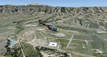
This region covers the area between Denver and Colorado Springs. It extends my Denver scenery to the south.
Just north of Colorado Springs you can see the widespread United States Air Force Academy which, with it's
many buildings, covers a huge area of 18.000 acres. The Academy Airfield (KAFF) which lays in the northeastern
corner of the area is used for training cadets in airmanship courses, including parachute training,
soaring and powered flight.
High resolution versions of this scenery for FS9 and FSX (much sharper, but larger and multiple downloads)
are available at www.blueskyscenery.com/GNB_South2East.html . The screenies are taken from the high-res versions,
so expect this version to be slightly more blurry. YourDonation@Work: Dedicated to Robin and Raymond.
| Filename: | Colorado_Springs_North_Colorado_PhotoScenery_FS9__.zip |
| License: | Freeware, limited distribution |
| Added: | 3rd February 2010, 02:09:59 |
| Downloads: | 2,187 |
| Author: | Gottfried Razek - blueskyscenery.com |
| Size: | 96.91 MB |
| Category: Flight Simulator 2004 - Scenery | |
| Mormon Range, Enterprise, Beryl (UT82), Utah, Photo-Scenery |
|
Images related to this file:
File Description:
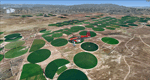
Mormon Range, Enterprise, Beryl (UT82), Utah, Photo-Scenery (FS9 & FSX)
This scenery covers the area of just north of St. George (KSGU) north along the Mormon Range and Enterprise to Beryl (UT82). It completes the southwestern corner of Utah and paves our way into Nevada. High resolution versions of this scenery for FS9 and FSX (much sharper, but larger and multiple downloads)are available at www.blueskyscenery.com/CNY_South2West6.html . The screenies are taken from the high-res versions, so expect this version to be slightly more blurry.
Thanks to Joop Mak for providing a custom AFCADs that correct airport layouts so that they align with the photo-textures! They are available at www.blueskyscenery.com/AFCADs.html . YourDonation@Work: Dedicated to Jean Pierre, Konrad and Juan.
| Filename: | Mormon_Range_Enterprise_Beryl_UT82_Utah_PhotoScene.zip |
| License: | Freeware, limited distribution |
| Added: | 27th March 2010, 11:38:48 |
| Downloads: | 1,367 |
| Author: | Gottfried Razek, blueskyscenery.com |
| Size: | 97.45 MB |
| Category: Flight Simulator 2004 - Scenery | |
| Bryce Canyon National Park (KBCE), Utah, Photo-Scenery |
|
Images related to this file:
File Description:
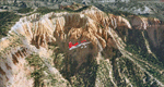
Bryce Canyon National Park (KBCE), Utah, Photo-Scenery (FS9 & FSX)
Despite its name, Bryce Canyon is not actually a canyon that was formed by a river, but rather a giant natural cliff shaped through erosion by wind, water, and ice. Bryce is distinctive due to its geological formations, delicate and colorful pinnacles called hoodoos that are up to 200ft high. The bizarre forms and red, orange and white colors of the rocks provide spectacular views. Unfortunately the hoodoos are too small for the elevation mesh in flight simulator. But you can enjoy the colors and shape of the cliffs. The cliffs in main region of the park, just south of the airport are partly covered
by snow. But on the southern and western part of the plateau you can enjoy them free of snow. Bryce Canyon is named after the Mormon pioneer Ebenezer Bryce who settled in this area in the 1850s. It was designated as a national park in 1928.
Bryce Canyon Airport (KBCE) just handles small aircraft on a daily basis. But is was actually built to handle larger aircraft in case of emergency. And so on Oct.6th 2000 an American Airlines MD-82 from Denver to Los Angeles made a successful emergency landing after reporting smoke in the cockpit and a loss of cabin pressure.
High resolution versions of this scenery for FS9 and FSX (much sharper, but larger and multiple downloads)are available at www.blueskyscenery.com/CNY_South2West4.html . The screenies are taken from the high-res versions, so expect this version to be slightly more blurry. Thanks to Joop Mak for providing a custom AFCADs that correct airport layouts so that they align with the photo-textures! They are available here: www.blueskyscenery.com/AFCADs.html . YourDonation@Work: Dedicated to Michael, Pat and Keith.
| Filename: | Bryce_Canyon_National_Park_KBCE_Utah_PhotoScenery.zip |
| License: | Freeware, limited distribution |
| Added: | 7th March 2010, 11:17:56 |
| Downloads: | 2,205 |
| Author: | Gottfried Razek, blueskyscenery.com |
| Size: | 96.35 MB |
| Category: Flight Simulator 2004 - Scenery | |
| 1960 Nice Airport Scenery (LFMN) Crash Tender Update |
|
Images related to this file:
File Description:

We have produced an animated (AI) French crashtender and also static models as an update to the existing 1960 LFMN Nice Airport scenery. You must have the original 1960 Nice Airport scenery installed first (nice_1960.zip).
| Filename: | 1960_Nice_Airport_Scenery_LFMN_Crash_Tender_Update.zip |
| License: | Freeware, limited distribution |
| Added: | 23rd March 2013, 15:23:17 |
| Downloads: | 2,209 |
| Author: | Harry Biard, Jaap de Baare and Bernhard Leuenberger |
| Size: | 1.29 MB |
| Category: Flight Simulator X - Scenery | |
| KLAX - Los Angeles International Airport, Photoreal Scenery (V3.0) |
|
Images related to this file:
File Description:

This Photo Real scenery is a complete rebuild for the FSX Default KLAX airport using the latest version of ADE ,Google SkecthUp, & SBuilderX scenery design tool. This new KLAX scenery, Version 3.0 includes new terminal buildings that have been resized and redesigned to look more realistic. I added terminal lights,(no night light lamps yet), new trees, cars to the parking garages, ground vehicles taxiway usage fixed, and several other nice details to enhance the KLAX experience. Other details included are the New Tom Bradley International Terminal, buildings located on W.Cenury Blvd, 9 Airbus A380 parking spots, and Photo Real ground textures. The runways and airport aprons are aligned to match Google & Yahoo satellite imagery. I hope you enjoy the scenery.
| Filename: | KLAX__Los_Angeles_International_Airport_Photoreal_.zip |
| License: | Freeware |
| Added: | 27th November 2011, 19:16:05 |
| Downloads: | 14,380 |
| Author: | Glenn Johnson |
| Size: | 16.28 MB |
| Category: Flight Simulator 2004 - Scenery | |
| Metropolitan Tel-Aviv Part 2 of Israel Scenery |
|
File Description:
FS2004 Scenery - Metropolitan Tel-Aviv. The second
part of Isreal Landclass covering 2,600 square km of
the central coastal area of Israel from Hadera to
Ashdod. Made in the highest detail, with all major
highways, all main roads and most of the secondary
roads, rail roads, coast lines, ports and marinas, all
cities and towns and villages from 500 residents and
above, rivers and water bodies, accurate vegetation,
sand dunes, quarries and other land uses needed for
VFR. The scenery is enhanced with night lighting to
enable easy VFR navigation by night.
| Filename: | Metropolitan_TelAviv_Part_2_of_Israel_Scenery.zip |
| License: | Freeware |
| Added: | 12th December 2003, 16:28:14 |
| Downloads: | 13,729 |
| Author: | Seev Kahn |
| Size: | 2.41 MB |
© 2001-2026 AVSIM Online
All Rights Reserved
Privacy Policy |