
Where Flight Simulation Enthusiasts Gather from Around the World!
AVSIM Library - Search Results

| Category: Flight Simulator X - Aircraft Repaints, Textures and Modifications | |
| Frontier Airlines (Weston the Woodpecker) Airbus A320 |

|
Images related to this file:
File Description:

Repaint for the Aerosoft Airbus A320 in Frontier Airlines (Weston the Woodpecker) livery
| Filename: | Frontier_Airlines_Weston_the_Woodpecker_Airbus_A32.zip |
| License: | Check within download |
| Added: | 15th July 2022, 21:50:09 |
| Downloads: | 111 |
| Author: | Lee Grant |
| Size: | 6.67 MB |
| Category: Flight Simulator X - Scenery | |
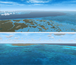
| Crooked & Acklins Islands (MYCI-MYAP) - The Bahamas |
|
Images related to this file:
File Description:
These islands are sparsely populated, but FSX with UTX-TAC has Crooked Island containing cities with high-rise buildings instead of settlements. This has been adjusted somewhat in this scenery. Bahamasair has flights twice weekly to these islands with the landing at MYCI being one of the more challenging due to rising terrain at the east end of the short and narrow runway. Parking has been provided to accommodate those AI flights in this package. The scenery includes custom scenery objects, placement of library objects and landclass changes. Scenery is based on Google Earth, Bing Maps and photos taken locally, and it is optimized for use with UTX-TAC.
| Filename: | Crooked__Acklins_Islands_MYCIMYAP__The_Bahamas.zip |
| License: | Freeware |
| Added: | 27th September 2013, 20:39:10 |
| Downloads: | 1,157 |
| Author: | Art Poole |
| Size: | 4.4 MB |
| Category: Flight Simulator X - Scenery | |
| MYAN - MYAF - MYAB - MYAK - Andros, The Bahamas |
|
Images related to this file:
File Description:

Includes scenery for the 4 principal airports and the AUTEC facility at Andros, Bahamas. The
scenery includes custom scenery objects, placement of library objects and landclass changes.
Scenery is based on Google Earth, Bing Maps and photos taken locally, and it is optimized for use
with UTX-TAC. Western Air static aircraft included at MYAN are from a model by Mike Stone
(www.pmstone.com) painted by Christopher Russell. This aircraft (FS2004 Western Air Fairchild
SA227 - AC Metro III) can be downloaded from the Flightsim.com or AVSIM library for use with an
AI traffic file included in this package.
| Filename: | MYAN__MYAF__MYAB__MYAK__Andros_The_Bahamas.zip |
| License: | Freeware |
| Added: | 2nd April 2014, 21:04:23 |
| Downloads: | 1,001 |
| Author: | Art Poole |
| Size: | 7.86 MB |
| Category: Flight Simulator 2004 - Scenery | |
| Paulatuk CYPC in the Northwest Territories, Canada |
|
Images related to this file:
File Description:
Paulatuk is on the coast of northern mainland Canada, 200 miles east of Tuktoyaktuk and 170 miles southwest of Ulukhaktok. It is just to the east of the Parry Peninsula, which has at its northern tip the Cape Parry DEW line Main Station. Paulatuk was established in the 1920's, and the population now numbers around 320. Paulatuk airfield is close to the village but on higher ground, while the village follows the curve of the coast. The 4,000 feet of 100 feet wide gravel runway is aligned 021T/201T where T stands for "true" as opposed to magnetic in the Northern Domestic Airspace. Only JETA-1 is available unless there is 100LL in drums. There are flights by Aklak Air from Inuvik, which is around 250 miles to the west; Aklak Air is actually Kenn Borek under a diferent name. The AI is for a daily passenger flight, and for a cargo flight on Wednesdays. In the summer, float planes use the lake to the south of the village, but I have no information as to docks or any other facilities; probably there aren't any.
| Filename: | Paulatuk_CYPC_in_the_Northwest_Territories_Canada.zip |
| License: | Freeware, limited distribution |
| Added: | 3rd December 2012, 21:58:47 |
| Downloads: | 277 |
| Author: | Roger Wensley |
| Size: | 4.39 MB |
| Category: Flight Simulator 2004 - Scenery | |
| Inuvik CYXT in the Northwest Territories, Canada |
|
Images related to this file:
File Description:
Inuvik is a town of 3,500 or so inhabitants at N68 18 W133 29, which puts it 120 miles inside the Arctic Circle on the east side of the Mackenzie River delta and around 90 miles from where the Mackenzie meets the Beaufort Sea. There is a Canadian Forces base at the eastern end of the field, with shelters for six F18 fighters; the base in one form or another has been there for a while and is the reason for the generous length of asphalt runway.
Inuvik was established in the early 1960's as a replacement regional center for Aklavik which is 40 miles to the west across the delta and which flooded on a regular and inconvenient basis. This probably works without Ultimate Terrain but I haven't tested it. I also haven't tested it in FSX but I was told it works there too.
| Filename: | Inuvik_CYXT_in_the_Northwest_Territories_Canada.zip |
| License: | Freeware, limited distribution |
| Added: | 6th October 2010, 13:22:04 |
| Downloads: | 942 |
| Author: | Roger Wensley |
| Size: | 4.12 MB |
| Category: Flight Simulator 2004 - Original Aircraft | |
| Lockheed P-38L-5: The Definitive Lightning |
|
File Description:
"P-38L-5: The Definitive Lightning," ver 2.1. Three texture sets: factory-fresh bare metal, Maj. Bong's "42" and John Raymond Johnson's "Jane." Full-featured FSDS2 model. Complete package, including authentic P-38 sounds recorded by the author. Includes some gauges by Mike Wagner and Chuck Dome. Texture assistance from Dan Swart.
| Filename: | Lockheed_P38L5_The_Definitive_Lightning.zip |
| License: | Freeware, limited distribution |
| Added: | 1st April 2004, 04:17:38 |
| Downloads: | 8,133 |
| Author: | David C. Copley |
| Size: | 14.27 MB |
| Category: Flight Simulator 2004 - Aircraft Repaints, Textures and Modifications | |
| BFU Repaint for the Bristol 170 Freighter |
|
File Description:
Bush Flying unlimited textures for Mike Stone's Bristol 170 Freighter. Textures only. Requires Mike Stones Bristol 170 Freighter available at http://www.pmstone.com/ Repaint By Brian Gladden.
| Filename: | BFU_Repaint_for_the_Bristol_170_Freighter.zip |
| License: | Freeware, limited distribution |
| Added: | 4th December 2004, 03:01:02 |
| Downloads: | 753 |
| Author: | Brian Gladden |
| Size: | 184.68 KB |
| Category: Flight Simulator X - Scenery | |
| South Florida and The Bahamas Water Class |
|
Images related to this file:
File Description:
The coverage area begins in the western end of the Florida Keys at The Dry Tortugas, heads north to Tampa, over to Grand Bahama, south to the Cay Sal Bank and eastward to Great Inagua covering all of the Florida Keys and the entire Bahamas Island chain. The scenery also corrects island position errors overlooked by UTX-USA and UTX-TAC in the Dry Tortugas, on the Cay Sal Bank, adding the missing Cays there and also on the Bahama Bank. Lighthouse placement error corrections are also included.
For those pilots with REX Essentials + Overdrive (REX3) a section of the manual is devoted to creating a custom selection of REX3 textures. by Wally-Bob
| Filename: | South_Florida_and_The_Bahamas_Water_Class.zip |
| License: | Freeware, limited distribution |
| Added: | 21st August 2014, 18:50:02 |
| Downloads: | 2,576 |
| Author: | Walter Roberts |
| Size: | 9.25 MB |
| Category: Flight Simulator 2004 - Scenery | |
| Lutselk'e CYLK in the Northwest Territories, Canada |
|
Images related to this file:
File Description:
Lutselk'e is a village on the southern shore of the Great Slave Lake, at the eastern end and about 120 miles east of Yellowknife. The Hudson Bay trading company established a post there in 1925, and the current school opened in 1960. The population is in the region of 330. There is no road access, but the government runs a freight shipping service during the ice-free period of the Summer. The airfield is a mile or so east of the village, with a runway of around 3,500 feet of gravel aligned 08-26 with PAPI at both ends and lit, with lights atop traffic cones. There are scheduled flights from Yellowknife by Air Tindi, included in the AI, as is a once a week freight flight by Buffalo Airways. You will need to have downloaded and installed my runway and taxiway lighting library from recent posts. A note here about my scenery making. There will not be many more to follow this as I am almost at the end of the photos I either took or found for scenery purposes, plus I expect to move on from FS9 at some point during next year.
| Filename: | Lutselke_CYLK_in_the_Northwest_Territories_Canada.zip |
| License: | Freeware, limited distribution |
| Added: | 9th December 2019, 18:04:52 |
| Downloads: | 104 |
| Author: | Roger Wensley |
| Size: | 3.25 MB |
| Category: Flight Simulator 2004 - Scenery | |
| Whati CEM3 in the Northwest Territories, Canada |
|
Images related to this file:
File Description:
Whati is a village at the southern end of Lac La Martre, a smaller lake (only by Canadian standards, at over 40 miles long) halfway between the Great Slave Lake and the Great Bear Lake and around 100 miles north of Yellowknife. The North West Company established a trading post there in 1793, and this was the centre for local trading in the area for 100 years until a post was opened by the Hudson Bay Company on the Great Slave Lake. The current population is in the region of 520. There is no graded road access and access is by boat or air. The main local economy revolves around hunting and fishing, with efforts being made to increase tourism amid the wilderness and the wildlife. The airfield is just over a mile east of the village, with a runway of around 3,400 feet of gravel aligned 09-27 as of 2010, with PAPI at both ends and lit. There are scheduled flights from Yellowknife by Air Tindi, included in the AI, and some GA. The terminal building is similar to that of Lutselk'e, but with a different colour scheme and with solar panels on the roof. It appears that they repaint the sign on the front of the building with a different wording every time; the one I have used is one of three that have existed in the last few years. The photos I had originally were taken in the winter, with snow. Seeing it in the summer I discovered that my version of the building is not at the right level above the ground by about a foot, or 30cm. I was too lazy to make it again, which was the only way to get it right and still have it throw a shadow on the ground. This scenery modifies the lake shore, corrects levels for land and lake, and adds the village and a connecting road in addition to the airport. A note here about my scenery making. There will not be many more to follow this as I am almost at the end of the photos I either took or found for scenery purposes, plus I expect to move on from FS9 at some point during next year.
| Filename: | Whati_CEM3_in_the_Northwest_Territories_Canada.zip |
| License: | Freeware, limited distribution |
| Added: | 15th December 2019, 19:18:29 |
| Downloads: | 148 |
| Author: | Roger Wensley |
| Size: | 4.25 MB |
© 2001-2026 AVSIM Online
All Rights Reserved
Privacy Policy |