
Where Flight Simulation Enthusiasts Gather from Around the World!
AVSIM Library - Search Results

| Category: Flight Simulator X - Aircraft Repaints, Textures and Modifications | |
| Boeing B-17G 91st BG (LL-Z) "Shamrock Special" |

|
Images related to this file:
File Description:
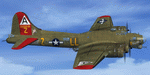
This folder contains a repaint for the A2A WoP2 B-17G in the colors of B-17F 42-29591 LL-Z "Tha Shamrock Special" of the 401st BS/ 91st BG based in Bassingbourne UK. Before being transferred to the 91st BG, this aircraft flew two missions with the 95th BG, as 'Easy Aces'. It came to the 91st in june 1943 and was assigned to the care of M.Sgt. Bob Dalton as crew chief. His assitent, Jack Gaffney named it 'The Shamrock Special', adnd painted two girls on either side of the nose, and later a third girl on the tail. This was probably the only aircraft in the 91st with three pieces of art on it. In november, the aircraft, while undergoing repairs, was hit by battle damaged Fort without brakes, ironically called 'the Careful Virgin'. The tail end was severely damaged during the collision, and the whole tail end was replaced with the tail of another aircraft that was damaged from the front. On 30 december 1943, she was back in action and completed another 12 missions, for a total of 26 with the 91st.
Repaint by Jan Kees Blom, based on the paintkit by A2A.
| Filename: | Boeing_B17G_91st_BG_LLZ_Shamrock_Special.zip |
| License: | Freeware |
| Added: | 7th October 2019, 18:21:48 |
| Downloads: | 83 |
| Author: | Jan Kees Blom |
| Size: | 18.09 MB |
| Category: Flight Simulator X - Scenery | |
| X2AD - RAF Aston Down - Gloucestershire, England |
|
File Description:
Former RAF Aston Down (IACO X2AD) is located 2.5 miles (4.0 km) east of Minchinhampton, Gloucestershire, South West England and 6.9 miles (11.1 km) west of Cirencester, Gloucestershire.
The airfield was originally opened as RAF Minchinhampton and was first used in the First World War, serving as an aerodrome for the Australian Flying Corps with No. 2 Squadron AFC flying the Royal Aircraft Factory S.E.5a and the Sopwith Pup and No. 3 Squadron AFC flying the Avro 504. The airfield closed shortly afterwards.
In 1938 the airfield reopened under the new name of RAF Aston Down at the request of the residents of Minchinhampton village, which lies about 1 mile (1.6 km) to the west of the airfield, who feared not enemy attack, but a fall in the value of their houses.
During the Second World War the main unit present was No. 20 Maintenance Unit RAF (MU) which stored and prepared aircraft. The unit arrived during October 1938 and left in September 1960.
The airfield was used by the Royal Air Force from the First World War until 1967 when the Cotswold Gliding Club moved in from their previous base near Tetbury.
| Filename: | X2AD__RAF_Aston_Down__Gloucestershire_England.zip |
| License: | Freeware |
| Added: | 3rd May 2016, 13:55:23 |
| Downloads: | 175 |
| Author: | Terry Boissel |
| Size: | 1.97 MB |
| Category: X-Plane - Scenery | |
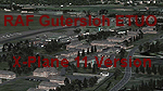
| RAF Gutersloh ETUO |
|
Images related to this file:
File Description:
File Description:
X-Plane 11 Scenery - RAF Gutersloh AB (ICAO: ETUO)
The scenery represents the former airbase of RAF Gutersloh, one of the most populated military bases in West Germany during the Cold War, due to its location near the former East/West border. This scenery reflects the era at the end of the 1980s/beginning of the 90s, when the Harrier GR3 was in operation there, along with Chinook helicopters.
The airfield was built in 1935 and was used by the German Air Force during WW2, flying the Junkers JU-86 and Heinkel H-111. The first British squadrons were stationed there from 1947, with Mosquitos, Vampires and then Canberras.
The first Harrier arrived at Gutersloh in January 1977 and 3 and 4 Squadrons became resident until their farewell in 1993, after the cold war had ended. The airfield is currently used by the British army, but they will leave in 2014 to relinquish the area to the Government of Gutersloh for civil usage.
High detailed scenery by Manfred Schyma and Pete Beeby, supported by the Airfield Construction Group. X-Plane Version designed by Dietmar Hanne
| Filename: | RAF_Gutersloh_ETUO.zip |
| License: | Freeware |
| Added: | 25th May 2018, 23:53:43 |
| Downloads: | 264 |
| Author: | Dietmar Hanne |
| Size: | 142.94 MB |
| Category: Flight Simulator 2004 - Scenery | |
| Hope Field near Ottawa Ontario, Canada |
|
Images related to this file:
File Description:
The field is newly included in the Canada Flight Supplement. Unusually for a grass field the runway has the numbers marked out in white; given that this is a private airfield that does not invite unexpected guests and has only one plane based there, and presuming that the owner can remember his own runway headings, it is unlikely that these will still be there in a year's time. There is no hangar as yet. To the west is highway 416 and to the east is the Rideau River, both of which run north-south. Lke Rockcliffe (which is to the north) the airfield is right on the edge of the Ottawa control zone, so you should already be below 1,500 feet ASL when approaching from the south and talking to Ottawa tower when arriving from the north. The runway is 07/25 and 2,800 feet long, which should be enough for almost anybody, and the field is at 315 feet ASL. Manotick is a mile to the north east on the Rideau River and the Rideau Valley Airpark CPL3 is six miles south in the bend of the Rideau where it turns west.
| Filename: | Hope_Field_near_Ottawa_Ontario_Canada.zip |
| License: | Freeware, limited distribution |
| Added: | 10th July 2010, 19:34:51 |
| Downloads: | 200 |
| Author: | Roger Wensley |
| Size: | 3.15 MB |
| Category: Flight Simulator 2004 - Scenery | |
| Akulivik CYKO in northern Quebec Canada |
|
Images related to this file:
File Description:
This is another of the many airfields that are all around the coast of Hudson Bay, this one being on the eastern, Quebec side. Akulivik is around 110 miles south of Ivujivik, which is on the northeastern corner of the Bay, and some 60 miles north of Puvirnituq. The population is 630 or so and the village grew from a move back to the area by one family in 1973, followed by others in the following years; the closure of the Hudson Bay trading post post in 1952 had pushed all residents to move south to Puvirnituq. The village is unusual in that it has a built harbour instead of the usual beached storage of boats. The village is built on the central prong of a three pronged spear of headlands (from which the village name is derived) while the airfield is a mile or so further inland. I have no information regarding what I think may be a new terminal building, so this includes only the old original one. The runway is just under 3,500 feet of gravel aligned 09-27, and the ai includes the scheduled flight by an Air Inuit Dash 8-300, plus GA.
| Filename: | Akulivik_CYKO_in_northern_Quebec_Canada.zip |
| License: | Freeware, limited distribution |
| Added: | 9th September 2018, 03:43:25 |
| Downloads: | 162 |
| Author: | Roger Wensley |
| Size: | 4.69 MB |
| Category: Flight Simulator 2004 - Scenery | |
| CZFN - Tulita - Northwest Territories, Canada |
|
Images related to this file:
File Description:
Tulita (Fort Norman until 1996) is another in the series of airfields that follow (approximately) the Mackenzie River. At the far northern end of the river and on the eastern side of the delta there is Tuktoyaktuk, then Inuvik, Fort McPherson, Fort Good Hope, Deline, Wrigley, Fort Simpson Island and Fort Simpson, and then Fort Liard at the southern end of the list of those in the Northwest Territories. South of Fort Liard there are Peace River and Dawson Creek, both of which are already posted. Tulita is at the junction of the Mackenzie and Great Bear Rivers, on the east bank of the Mackenzie and the south bank of the Great Bear, around 40 miles southeast of Norman Wells. The town has a population of about 480 folks. The airport is above and to the east of the town, and has 3,000 feet of gravel runway. The scheduled flights are by North Wright and I have also added a Buffalo DC3 and GA. There is a mandatory radio frequency but in this case I have set the "tower" to "unmanned" so you will report position and intentions. There is no fuel available.
| Filename: | CZFN__Tulita__Northwest_Territories_Canada.zip |
| License: | Freeware, limited distribution |
| Added: | 12th July 2014, 08:05:54 |
| Downloads: | 272 |
| Author: | Roger Wensley |
| Size: | 2.66 MB |
| Category: X-Plane - Original Aircraft | |
| Black Cat PBY5/5A |
|
File Description:
X-Plane 6.40
The PBY Catalina is probably the best known flying boat with over 4000 produced by Consolidated aircraft and licensees. The Black Cat squadrons all done in flat black played havoc particularly for the Japanese in the Pacific in WWII. Fitted with radar, with a 15 hour endurance and 2800 mile range they hunted Japanese naval ships and bombed or torpedoed them by the hundreds. This a fairly accurate rendition of the PBY except that the retractable pontoons are missing. Why? Well basically after using all the tricks I know I ran out of parts. There are 6 engine nacelles used in the model, 2 represent the 1200 HP radial engines driving the props, the others are jets with 5 lbs of thrust, 1 is used for the rear fuselage section, 1 is used for the wing pylon, 1 is used for the flare from the fuselage to the vertical stabilizer and the last is used for the forward observation and gunner space. Two are not used. Wing sections are taken up by the main wing and the support spars so there you go. The fuel tanks are used for the side gunner pods since these can be decorated separately. The plane flies very well and is stable. Takeoffs from water are quite easy as long as you don't dip a wing tip (no floats remember). This aircraft model and the paint scheme is copyright by Robert App, January 2003. Feel free to alter the paint scheme and instrument panel as long as you give me credit for the original design. The Black Cat squadron logo used in the paint scheme is courtesy of http://www.daveswarbirds.com/blackcat/logos.htm and is from the VP-71 Black Cat squadron. E mail me with any good panels or paint schemes and I will give full credit if used.
| Filename: | Black_Cat_PBY55A.zip |
| License: | Freeware, limited distribution |
| Added: | 16th January 2003, 02:56:49 |
| Downloads: | 1,386 |
| Author: | Robert L. App |
| Size: | 12.04 MB |
| Category: Flight Simulator 2004 - Scenery | |
| Knight Inlet CF36 float base in British Columbia, Canada |
|
Images related to this file:
File Description:
Knight Inlet is a floating lodge that organises "nature experiences", ranging from close encounters with local grizzly bears to fishing. Knight Inlet is to the north of "the narrows" where the Inside Passage gets squeezed between the mainland and Vancouver Island, and there is a chart section attached with a pointer to the location. At the bottom of the chart is Campbell River floatbase, and to the west is Port Hardy. Knight Inlet initially runs east-west, and the lodge is tucked into a smaller north-south offshoot, close to where the main inlet turns north. The water runway here is in the middle of the north-south offshoot, though of course in reality the "runway" is wherever the wind dictates it to be. The names highlighted in green on the chart are float bases to be renovated and posted with working AI. The buoyed log boom next to the lodge is to keep escaped logs from drifting in and colliding with boats; float plane pilots keep their eyes peeled too. Because of large hills adjacent to the lodge the landing of the AI may or may not take place, depending on wind direction and whether or not they fly into rock before landing. Take off and departure are far more reliable, particularly if the wind is from the south. Most of the AI is from Vancouver Harbour, Harbour Air Otters and West Coast Air Beavers, plus a SeAir Beaver from Campbell River and a private Cessna from the nearby Minstrel Island. This is the second in a series of new and renovated float bases in BC (the first being Sproat Lake) and to cope with the AI demands FSAddon have authorised the inclusion here of a bunch of AI Otters and Beavers that were originally part of a payware scenery for the area. Thanks are due there.
| Filename: | Knight_Inlet_CF36_float_base_in_British_Columbia_C.zip |
| License: | Freeware, limited distribution |
| Added: | 23rd December 2016, 08:16:24 |
| Downloads: | 219 |
| Author: | Roger Wensley |
| Size: | 16.95 MB |
| Category: Flight Simulator X - Aircraft Repaints, Textures and Modifications | |
| Aegean Airlines Airbus A320 |
|
File Description:
This is one of the two Aegean aircraft having the characteristic logo an the left hand side of the fuselage, advertising the
Athens Acropolis museum. For Overland SMS Airbus A320 IAE model.
| Filename: | Aegean_Airlines_Airbus_A320.zip |
| License: | Freeware |
| Added: | 17th October 2014, 23:12:13 |
| Downloads: | 207 |
| Author: | Dimitrios Moschos |
| Size: | 6.85 MB |
| Category: Flight Simulator X - Aircraft Repaints, Textures and Modifications | |
| Qantas "Retro Roo 2" Boeing 737-800 |
|
File Description:
This is the second retro livery for the Qantas 737 fleet and it is based on the livery of the first Qantas Boeing 707. Textures only for the default FSX B737-800.
| Filename: | Qantas_Retro_Roo_2_Boeing_737800.zip |
| License: | Freeware |
| Added: | 26th November 2015, 21:14:26 |
| Downloads: | 241 |
| Author: | Peter Holtham |
| Size: | 3.17 MB |
© 2001-2026 AVSIM Online
All Rights Reserved
Privacy Policy |