
Where Flight Simulation Enthusiasts Gather from Around the World!
AVSIM Library - Search Results

| Category: Flight Simulator 2002 - Original Aircraft | |
| The Tiger Moth Collection |

|
File Description:
FS2002 De Havilland Tiger Moth Collection.
My tribute to this wonderful aircraft.
10 landplane paint schemes plus a floatplane.
All textures are new (including the original
3 RAF models) and are repaint friendly. Other
changes include a new 2D panel, VC lighting,
and many minor changes. Gipsy Major sounds by
Mike Hambly. Model, textures & panels by John Woodside. 2D
Panel concept by Eliezer Rice based on a photo by Claude Manet.
| Filename: | The_Tiger_Moth_Collection.zip |
| License: | Freeware, limited distribution |
| Added: | 19th October 2002, 17:45:15 |
| Downloads: | 7,104 |
| Author: | John Woodside, Mike Hambly |
| Size: | 10.1 MB |
| Category: Flight Simulator X - Scenery | |
| The Real VCBI X |
|
Images related to this file:
File Description:

This is the complete & high detailed scenery of Bandaranaike International Airport
for Microsoft Flight Simulator X. If you are a Sri Lankan flightsimmer or like to fly
around Sri Lanka in Flight Simulator X, then this is a must for you!.
Features -: High quality Satellite terrain.
G-Max�������® designed terminal and other buildings.
Accurate building and apron placement.
Extremely high detailed terminal and surroundings.
Re-Adjusted glide scope and localizer to match actual situation.
Road traffic animations and other effects.
High detailed Autogen data.
| Filename: | The_Real_VCBI__X.zip |
| License: | Freeware, limited distribution |
| Added: | 4th October 2011, 08:00:05 |
| Downloads: | 8,597 |
| Author: | Gayan Liyanaarachchi |
| Size: | 22.65 MB |
| Category: Flight Simulator 2004 - AI Aircraft | |
| The Ultimate Gulfstream 3 |
|
File Description:
Ultimate GA brings you another huge release, the Ultimate Gulfstream 3 AI package. This pack contains 158 repaints covering all known Gulfstream 3's in service.
All civil, government and military operators are included, as are highly realistic flightplans operating over 2500 weekly sectors and Henry Tomkiewicz's
excellent AI aircraft model. Very easy installation for FS2004 users and flight plan textfiles are included for FS2002 users.
| Filename: | The_Ultimate_Gulfstream_3.zip |
| License: | Freeware, limited distribution |
| Added: | 4th November 2005, 14:07:32 |
| Downloads: | 12,985 |
| Author: | Ultimate GA / Henry Tomkiewicz |
| Size: | 21.71 MB |
| Category: Flight Simulator 2004 - Scenery | |
| Hungary and the Carpatians |
|
File Description:
This is a terrain mesh scenery for Hungary, the Carpatians, and for parts of the Transcarpathian territory. Based on SRTM Data (3 arc/sec), generated with Matthew Styles's program "SRTM To BGL v1.04", sampled to LOD9 resolution (76m) with 5 interpolation passes. While tested with Fs2002, this mesh should also run in FS2004.
| Filename: | Hungary_and_the_Carpatians.zip |
| License: | Freeware |
| Added: | 11th January 2004, 01:23:20 |
| Downloads: | 7,393 |
| Author: | Peter Papics |
| Size: | 66 MB |
| Category: Flight Simulator X - Scenery | |
| Mayaguana (MYMM) - The Bahamas |
|
Images related to this file:
File Description:
Mayaguana is the easternmost island in the Bahamas with Bahamasair providing Nassau and Inagua air connections. The airport utilizes part of an abandoned 11,000 foot USAF runway. The runway is listed as 7300 foot long, but 2400 feet on the east end is closed indefinitely. A new terminal building was completed, but no apron or taxiway connects it to the runway so it is unoccupied. Construction was started on another terminal, apron and taxiway as well as runway repaving, but the project is currently abandoned. All of the aforegoing is represented by this scenery. The scenery includes custom scenery objects; placement of library objects and landclass changes. Scenery is based on Bing Maps and photos taken locally, and it is optimized for use with UTX-TAC.
| Filename: | Mayaguana_MYMM__The_Bahamas.zip |
| License: | Freeware |
| Added: | 20th April 2013, 20:18:45 |
| Downloads: | 1,120 |
| Author: | Art Poole |
| Size: | 1.04 MB |
| Category: Flight Simulator X - Scenery | |
| Inagua - The Bahamas (MYIG) |
|
Images related to this file:
File Description:
MYIG is the southernmost airport in the Bahamas. At nearby Matthew Town is the Morton Salt Company's main facility - Inagua's main industry. The scenery includes custom scenery objects; placement of library objects and landclass changes. The airport is also moved to it's proper location. Scenery is based on Google Earth and Microsoft Bing imagery and photos taken locally, and it is optimized for use with or without UTX-TAC.
| Filename: | Inagua__The_Bahamas_MYIG.zip |
| License: | Freeware |
| Added: | 21st December 2012, 18:12:48 |
| Downloads: | 1,252 |
| Author: | Art Poole |
| Size: | 365.77 KB |
| Category: Flight Simulator X - Scenery | |
| Bimini, The Bahamas (MYBS) |
|
Images related to this file:
File Description:
Both North and South Bimini islands landclass, shorelines and water, as well as the South Bimini Airport, have been redone per Google Earth images. This is NOT photo scenery.
| Filename: | Bimini_The_Bahamas_MYBS.zip |
| License: | Freeware |
| Added: | 7th March 2010, 12:08:16 |
| Downloads: | 2,677 |
| Author: | Art Poole |
| Size: | 314.96 KB |
| Category: Civil Flight Simulators - Looking Glass Flight Unlimited 3 | |
| Ships in The Solent |
|
File Description:
A package adding ship traffic in The Solent. I've added all the ferry routes to the Isle of Wight.
| Filename: | Ships_in_The_Solent.zip |
| License: | Freeware |
| Added: | 22nd March 2003, 19:06:30 |
| Downloads: | 186 |
| Author: | Roland Wagener |
| Size: | 5.84 KB |
| Category: Flight Simulator 2004 - Utilities | |
| The New ChartMap, v4 |
|
File Description:
The new ChartMap_ver4 is a program completely rebuilding with a new graphics power and a new database. Now is possible to use the PDF format for every kind of charts. You can everywhere download it. The important thing is to use the conventional letter below in this tutorial (vds restrictions). This is a new version.
ChartMap_ver4 is a small stand-alone Windows utility for Flight Simulators allowing a number of airport charts to be stored and available on screen whilst still flying.
The database is empty. To work download Italians Airports Charts and Procedures Series 1, 2 and 3.
| Filename: | The_New_ChartMap_v4.zip |
| License: | Freeware |
| Added: | 30th January 2010, 09:42:02 |
| Downloads: | 2,485 |
| Author: | Carlo Chiappisi |
| Size: | 1.07 MB |
| Category: Flight Simulator 2004 - Scenery | |
| Argentina and the Andes |
|
Images related to this file:
File Description:
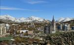
Scenery Argentina and the Andes scenery. Includes 17 airports near the Andes and in the metropolitan area of Buenos Aires. Also includes some cities such as Ushuaia, San Carlos de Bariloche etc. plus important mountains and valleys.
When I built the scenario of Chile I realized several virtual voyages toward Argentina crossing the Andes for different points when arrived to the Argentina sector found the classic airports made fs2004 and it was defrauded. This prompted me to build the present scenario. Also suggested are Chile north (chile_north.zip) and Chile South (chile_south.zip) - Its a perfect complement.
| Filename: | Argentina_and_the_Andes.zip |
| License: | Freeware |
| Added: | 11th December 2009, 12:11:55 |
| Downloads: | 1,943 |
| Author: | Toni Agramont |
| Size: | 61.29 MB |
© 2001-2026 AVSIM Online
All Rights Reserved
Privacy Policy |