
Where Flight Simulation Enthusiasts Gather from Around the World!
AVSIM Library - Search Results

| Category: Flight Simulator 2002 - Aircraft Repaints, Textures and Modifications | |
| Northwest Airlines Douglas DC-9-40 (AI Aardvark) |

|
File Description:
A dc-9-40 designed especially for AI traffic.
Features 4 LOD models and moving parts.
Very detailed, includes animated gear, flaps
& spoilers, antennas, flap canoes and
simulated gear bays and specular highlights.
Extremely frame rate friendly.
Includes optional reflective model.
| Filename: | Northwest_Airlines_Douglas_DC940_AI_Aardvark.zip |
| License: | Freeware, limited distribution |
| Added: | 26th February 2003, 21:43:56 |
| Downloads: | 5,923 |
| Author: | Craig Crawley / David Carter |
| Size: | 330.8 KB |
| Category: Flight Simulator X - AFCAD Files | |
| MMSD - Los Cabos International Airport |
|
File Description:
* Created using ADE version 1.47, based on import of stock FSX airport.
* Added taxiway A and supporting taxiways
* Adjusted taxiways, aprons, buildings, parking spots, airport boundary, and various airport objects, based on most recent Google Earth.
* Assigned taxi signs, set REIL runway lighting, and other miscellaneous, as per Aug 2009 aerodrome chart.
| Filename: | MMSD__Los_Cabos_International_Airport.zip |
| License: | Freeware |
| Added: | 4th May 2011, 06:09:31 |
| Downloads: | 925 |
| Author: | William Ruppel |
| Size: | 5.68 KB |
| Category: Flight Simulator 2004 - Panels | |
| Panel Icon for Airport Chart Viewer Program - with an illustrated installation guide. |
|
File Description:
Panel Icon for use with Airport Chart Viewer Program - with an illustrated installation guide. This package provides a panel icon for use with the fine program by Holger Maass - apchart.zip. Because it is listed in the FSX category here in the library, many may not be aware the program works well in FS2004 also. I have created this panel icon to easily invoke the Chart Viewer while flying. No programming knowledge is required. The icon can be added to vitually any panel and setups for the default Beech Baron 58 and B737-400 are included. Please unzip this package to a temporary folder and follow the instructions. The guide has been compiled in .DOC and .PDF formats for your flying enjoyment by David "Opa" Marshall.
| Filename: | Panel_Icon_for_Airport_Chart_Viewer_Program__with_.zip |
| License: | Freeware |
| Added: | 19th March 2009, 20:43:35 |
| Downloads: | 9,864 |
| Author: | David "Opa" Marshall |
| Size: | 366.7 KB |
| Category: Navigation and ATC - Navigation | |
| Lake Huron Chart Chunks Optimized For Moving Map Application |
|
File Description:
Sectional chart chunks made from the August 2009 Sectional charts at the original scale, formatted in the WGS84 lat/lon geographic coordinate system for GPS, moving map application for flight simulation use.
These chart chunks were converted to the JPEG format for compatibility and size. Coverage is the full Sectional area North and South divided into 8 JPEG tiles. They are about 3k x 3k pixels at 2.5mb with coverage of 90nm x 130nm per tile. Included is also the projection files and world files.
Note: This type of map is a equal grid and no further calibration is needed, only the two points referenced in the world file. Example: for users of FSM Moving Map, just mass import, done.
| Filename: | Lake_Huron_Chart_Chunks_Optimized_For_Moving_Map_A.zip |
| License: | Freeware |
| Added: | 20th February 2010, 22:08:53 |
| Downloads: | 129 |
| Author: | David Myers |
| Size: | 20.82 MB |
| Category: Navigation and ATC - Navigation | |
| Kansas City Chart Chunks Optimized For Moving Map Application |
|
File Description:
Sectional chart chunks made from the August 2009 Sectional charts at the original scale, formatted in the WGS84 lat/lon geographic coordinate system for GPS, moving map application for flight simulation use.
These chart chunks were converted to the JPEG format for compatibility and size. Coverage is the full Sectional area North and South divided into 8 JPEG tiles. They are about 3k x 3k pixels at 2.5mb with coverage of 90nm x 130nm per tile. Included is also the projection files and world files.
Note: This type of map is a equal grid and no further calibration is needed, only the two points referenced in the world file. Example: for users of FSM Moving Map, just mass import, done.
| Filename: | Kansas_City_Chart_Chunks_Optimized_For_Moving_Map_.zip |
| License: | Freeware |
| Added: | 20th February 2010, 23:07:30 |
| Downloads: | 116 |
| Author: | David Myers |
| Size: | 18.54 MB |
| Category: Navigation and ATC - Navigation | |
| Klamath Falls Chart Chunks Optimized For Moving Map Application |
|
File Description:
Sectional chart chunks made from the August 2009 Sectional charts at the original scale, formatted in the WGS84 lat/lon geographic coordinate system for GPS, moving map application for flight simulation use.
These chart chunks were converted to the JPEG format for compatibility and size. Coverage is the full Sectional area North and South divided into 8 JPEG tiles. They are about 3k x 3k pixels at 2.5mb with coverage of 90nm x 130nm per tile. Included is also the projection files and world files.
Note: This type of map is a equal grid and no further calibration is needed, only the two points referenced in the world file. Example: for users of FSM Moving Map, just mass import, done.
| Filename: | Klamath_Falls_Chart_Chunks_Optimized_For_Moving_Ma.zip |
| License: | Freeware |
| Added: | 20th February 2010, 23:07:41 |
| Downloads: | 107 |
| Author: | David Myers |
| Size: | 21.37 MB |
| Category: Navigation and ATC - Navigation | |
| Green Bay Chart Chunks Optimized For Moving Map Application |
|
File Description:
Sectional chart chunks made from the August 2009 Sectional charts at the original scale, formatted in the WGS84 lat/lon geographic coordinate system for GPS, moving map application for flight simulation use.
These chart chunks were converted to the JPEG format for compatibility and size. Coverage is the full Sectional area North and South divided into 8 JPEG tiles. They are about 3k x 3k pixels at 2.5mb with coverage of 90nm x 130nm per tile. Included is also the projection files and world files.
Note: This type of map is a equal grid and no further calibration is needed, only the two points referenced in the world file. Example: for users of FSM Moving Map, just mass import, done.
| Filename: | Green_Bay_Chart_Chunks_Optimized_For_Moving_Map_Ap.zip |
| License: | Freeware |
| Added: | 20th February 2010, 23:41:23 |
| Downloads: | 109 |
| Author: | David Myers |
| Size: | 18.82 MB |
| Category: Navigation and ATC - Navigation | |
| Great Falls Chart Chunks Optimized For Moving Map Application |
|
File Description:
Sectional chart chunks made from the August 2009 Sectional charts at the original scale, formatted in the WGS84 lat/lon geographic coordinate system for GPS, moving map application for flight simulation use.
These chart chunks were converted to the JPEG format for compatibility and size. Coverage is the full Sectional area North and South divided into 8 JPEG tiles. They are about 3k x 3k pixels at 2.5mb with coverage of 90nm x 130nm per tile. Included is also the projection files and world files.
Note: This type of map is a equal grid and no further calibration is needed, only the two points referenced in the world file. Example: for users of FSM Moving Map, just mass import, done.
| Filename: | Great_Falls_Chart_Chunks_Optimized_For_Moving_Map_.zip |
| License: | Freeware |
| Added: | 20th February 2010, 23:41:53 |
| Downloads: | 127 |
| Author: | David Myers |
| Size: | 23.6 MB |
| Category: Navigation and ATC - Navigation | |
| Dallas-Ft Worth Chart Chunks Optimized For Moving Map Application |
|
File Description:
Sectional chart chunks made from the August 2009 Sectional charts at the original scale, formatted in the WGS84 lat/lon geographic coordinate system for GPS, moving map application for flight simulation use.
These chart chunks were converted to the JPEG format for compatibility and size. Coverage is the full Sectional area North and South divided into 8 JPEG tiles. They are about 3k x 3k pixels at 2.5mb with coverage of 90nm x 130nm per tile. Included is also the projection files and world files.
Note: This type of map is a equal grid and no further calibration is needed, only the two points referenced in the world file. Example: for users of FSM Moving Map, just mass import, done.
| Filename: | DallasFt_Worth_Chart_Chunks_Optimized_For_Moving_M.zip |
| License: | Freeware |
| Added: | 21st February 2010, 01:39:48 |
| Downloads: | 159 |
| Author: | David Myers |
| Size: | 17.99 MB |
| Category: Flight Simulator 2004 - Aircraft Repaints, Textures and Modifications | |
| Lockheed C-130J Super Hercules "Hurricane Hunters" 403rd WG/53rd WRS |
|
Images related to this file:
File Description:
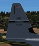
FS2004 Lockheed C-130J Hercules. The C-130J is also known as the "Super Hercules". The 403rd currently uses ten of these equipped with all kinds of gadgets including palletized meteorological data-gathering instruments. Each plane has five crew positions. These are amazing aircraft, and in light of hurricane season these textures were developed. They were originally developed for the SIMulated Air Force, a VATSIM MSOA. Model by Mike Stone. Textures by Jason Norment. Textures Only Included!
| Filename: | Lockheed_C130J_Super_Hercules_Hurricane_Hunters_40.zip |
| License: | Freeware |
| Added: | 28th April 2010, 18:10:44 |
| Downloads: | 210 |
| Author: | Jason Norment, Mike Stone |
| Size: | 669.07 KB |


© 2001-2026 AVSIM Online
All Rights Reserved
Privacy Policy |