
Where Flight Simulation Enthusiasts Gather from Around the World!
AVSIM Library - Search Results

| Category: Fly! II - Navigation | |
| 16 Navaids DK |

|
File Description:
16 Add-on navigation (NAVs) from Aeronautical chart- ICAO 1:500,000
| Filename: | 16_Navaids_DK.zip |
| License: | Freeware |
| Added: | 1st June 2003, 13:25:51 |
| Downloads: | 410 |
| Author: | Skovbjerg Lars |
| Size: | 1.56 KB |
| Category: Flight Simulator 2004 - AFCAD Files | |
| ZMBH Bayankhongor Mongolia |
|
File Description:
Afcad for Bayankhongor, made using Jeppesen aerodrome chart and Google earth.
| Filename: | ZMBH_Bayankhongor_Mongolia.zip |
| License: | Freeware |
| Added: | 9th December 2013, 18:55:58 |
| Downloads: | 183 |
| Author: | Nick Langley |
| Size: | 1.82 KB |
| Category: Flight Simulator 2004 - Aircraft Repaints, Textures and Modifications | |
| CFS2/FS2004 Republic P-47D Thunderbolt Bubble Top White 39, Soviet Air Force |
|
File Description:
CFS2/FS2004 Republic P-47D Thunderbolt Bubble Top White 39, Soviet Air Force. This repaint is for the ALPHASIM model which can be found at: http://www.alphasim3.com/store/advanced_search_result.php?keywords=P-47&x=7&y=9 . Repaint by Evan G. Butterbrodt (revev) [email protected].
| Filename: | CFS2FS2004_Republic_P47D_Thunderbolt_Bubble_Top_Wh.zip |
| License: | Freeware |
| Added: | 20th June 2008, 22:34:31 |
| Downloads: | 88 |
| Author: | Evan G. Butterbrodt |
| Size: | 1.33 MB |
| Category: Flight Simulator 2004 - Aircraft Repaints, Textures and Modifications | |
| CFS2/FS9 Republic P-47D Thunderbolt Bubble Top White 39, Soviet Air Force |
|
Images related to this file:
File Description:
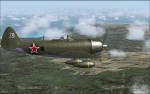
CFS2/FS9 Republic P-47D Thunderbolt Bubble Top White 39, Soviet Air Force. This repaint is for the ALPHASIM model which can be found at: http://www.alphasim3.com/store/advanced_search_result.php?keywords=P-47&x=7&y=9 . Repaint by Evan G. Butterbrodt (revev). Enjoy!
| Filename: | CFS2FS9_Republic_P47D_Thunderbolt_Bubble_Top_White.zip |
| License: | Freeware |
| Added: | 28th May 2010, 02:42:28 |
| Downloads: | 119 |
| Author: | Evan G. Butterbrodt |
| Size: | 1.32 MB |
| Category: Flight Simulator 2004 - Aircraft Repaints, Textures and Modifications | |
| CFS2/FS2004 Republic P-47D Thunderbolt Bubble Top, 4434/34, Portuguese Air Force |
|
File Description:
CFS2/FS2004 Republic P-47D Thunderbolt Bubble Top, 4434/34, Portuguese Air Force, 1952. This repaint is for the ALPHASIM model which can be found at: http://www.alphasim3.com/store/advanced_search_result.php?keywords=P-47&x=7&y=9. Repaint by Evan G. Butterbrodt (revev).
| Filename: | CFS2FS2004_Republic_P47D_Thunderbolt_Bubble_Top_44.zip |
| License: | Freeware |
| Added: | 16th August 2008, 05:22:42 |
| Downloads: | 81 |
| Author: | Evan G. Butterbrodt |
| Size: | 1.92 MB |
| Category: Combat Flight Simulator 1 and 2 - Aircraft | |
| CFS2/FS2004 Republic P-47D Thunderbolt Bubble Top, 4434/34, Portuguese Air Force |
|
File Description:
CFS2/FS2004 Republic P-47D Thunderbolt Bubble Top, 4434/34, Portuguese Air Force, 1952. This repaint is for the ALPHASIM model which can be found at: http://www.alphasim3.com/store/advanced_search_result.php?keywords=P-47&x=7&y=9. Repaint by Evan G. Butterbrodt (revev)
| Filename: | CFS2FS2004_Republic_P47D_Thunderbolt_Bubble_Top_44.zip |
| License: | Freeware |
| Added: | 16th August 2008, 03:20:46 |
| Downloads: | 24 |
| Author: | Evan G. Butterbrodt |
| Size: | 1.92 MB |
| Category: Combat Flight Simulator 1 and 2 - Aircraft | |
| CFS2/FS2004 Republic P-47D Thunderbolt Bubble Top White 39, Soviet Air Force |
|
File Description:
CFS2/FS2004 Republic P-47D Thunderbolt Bubble Top White 39, Soviet Air Force. This repaint is for the ALPHASIM model which can be found at: http://www.alphasim3.com/store/advanced_search_result.php?keywords=P-47&x=7&y=9 . Repaint by Evan G. Butterbrodt (revev) [email protected].
| Filename: | CFS2FS2004_Republic_P47D_Thunderbolt_Bubble_Top_Wh.zip |
| License: | Freeware |
| Added: | 20th June 2008, 22:28:46 |
| Downloads: | 30 |
| Author: | Evan G. Butterbrodt |
| Size: | 1.33 MB |
| Category: Flight Simulator 2004 - Aircraft Repaints, Textures and Modifications | |
| CFS2/FS2004 Republic F47D Thunderbolt Bubble-Top, 5-11, 5th Stormo Caccia Terrestre, Italian Air Force |
|
File Description:
CFS2/FS2004 Republic F47D Thunderbolt Bubble-Top, 5-11, 5th Stormo Caccia Terrestre, Italian Air Force, 1952. Note: After 1948 The USAAF re-designated the surviving P47 aircraft to F47; changing the "P" designation (Pursuit) to "F" (fighter). This repaint is for the ALPHASIM model which can be found at: http://www.alphasim3.com/store/advanced_search_result.php?keywords=P-47&x=7&y=9 . Repaint by Evan G. Butterbrodt (revev) [email protected].
| Filename: | CFS2FS2004_Republic_F47D_Thunderbolt_BubbleTop_511.zip |
| License: | Freeware |
| Added: | 28th July 2008, 03:07:50 |
| Downloads: | 94 |
| Author: | Evan G. Butterbrodt |
| Size: | 2.11 MB |
| Category: Combat Flight Simulator 1 and 2 - Aircraft | |
| CFS2/FS2004 Republic F47D Thunderbolt Bubble-Top, 5-11, 5th Stormo Caccia Terrestre, Italian Air Force |
|
File Description:
CFS2/FS2004 Republic F47D Thunderbolt Bubble-Top, 5-11, 5th Stormo Caccia Terrestre, Italian Air Force, 1952. Note: After 1948 The USAAF re-designated the surviving P47 aircraft to F47; changing the "P" designation (Pursuit) to "F" (fighter). This repaint is for the ALPHASIM model which can be found at: http://www.alphasim3.com/store/advanced_search_result.php?keywords=P-47&x=7&y=9 . Repaint by Evan G. Butterbrodt (revev) [email protected].
| Filename: | CFS2FS2004_Republic_F47D_Thunderbolt_BubbleTop_511.zip |
| License: | Freeware |
| Added: | 28th July 2008, 03:06:45 |
| Downloads: | 70 |
| Author: | Evan G. Butterbrodt |
| Size: | 2.11 MB |
| Category: Flight Simulator 2002 - Miscellaneous Files | |
| Nome Sectional Chart |
|
File Description:
I have always associated Nome with the Iditarod Trail Sled Dog Race of which I read first as a teenager some twenty years ago. The outpost really doesn´t make the news all that often. Do you plan to fly around the globe? Fairbanks - Nome may be your last leg on the American continent. If you don´t: "FAA urges all pilots operating in the Bering Strait area to take utmost precaution to avoid Russion airspace."
While it can be used "as is" without any other software, it will develop its full potential if used as moving map with SimSystem´s FSFlightMax or FSGarmin.
| Filename: | Nome_Sectional_Chart.zip |
| License: | Check within download |
| Added: | 25th March 2003, 14:05:37 |
| Downloads: | 966 |
| Author: | Uwe Rademacher |
| Size: | 18.42 MB |
© 2001-2026 AVSIM Online
All Rights Reserved
Privacy Policy |