
Where Flight Simulation Enthusiasts Gather from Around the World!
AVSIM Library - Search Results

| Category: Flight Simulator X - Scenery | |
| VOBL - Bengaluru International Airport |

|
File Description:
Bengaluru International Aiport, Bangalore, India. This is a very accurate scenery as of 2012. Features whole airport (not included by default in FSX), gates equiped to handle A380 traffic. Hope you enjoy!!
| Filename: | VOBL__Bengaluru_International_Airport.zip |
| License: | Freeware |
| Added: | 4th May 2012, 15:53:58 |
| Downloads: | 2,485 |
| Author: | Rj Gill |
| Size: | 5.38 KB |
| Category: Flight Simulator 2004 - Scenery | |
| Australs Islands Tahiti |
|
File Description:
VFR flight for Australs island (TAHITI) and Tahiti. In this scenery : Tahiti+ Maria+ Rimatara + Ruturu + Tubuai + Raivavae. Add : Landclass, tahiti seaport, local mesh, buildings, boats, effects (fall), traffic AI...
2 new airports
| Filename: | Australs_Islands_Tahiti.zip |
| License: | Freeware, limited distribution |
| Added: | 17th October 2006, 14:17:33 |
| Downloads: | 4,911 |
| Author: | Olivier Bochu |
| Size: | 1.96 MB |
| Category: Flight Simulator 2004 - Scenery | |
| FS2004 Scenery-UB0Z (UB13/UDKS)-Stepanakert-Khangedi AB and civil - Russian BKS in Nagorni-Karabach |
|
File Description:
FS2004 Scenery-UB0Z (UB13/UDKS)-Stepanakert-Khangedi AB and civil - Russian BKS in Nagorni-Karabach
Based on open photos available and Ultimate Terrain Europe. Please see Install notes for necessary object files and enjoy.
| Filename: | FS2004_SceneryUB0Z_UB13UDKSStepanakertKhangedi_AB_.zip |
| License: | Freeware |
| Added: | 17th June 2023, 17:07:36 |
| Downloads: | 45 |
| Author: | Bernd Barsch |
| Size: | 5.63 MB |
| Category: Flight Simulator 2004 - Scenery | |
| Zion National Park South, Hurricane (1L8), Colorado City (KAZC), Utah/Arizona, Photo-Scenery (FS9 & FSX) |
|
Images related to this file:
File Description:
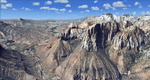
Covers the southern part of Zion National Park extends south along the cities of Hurricane and Colorado City. Zion National Park is another place where erosion of the Colorado Plateau formed the most beautiful colorful stone formations of unique and wonderful shapes. There are nine different layers of stone visible in the park. Most of them consist of sandstone. But there is also limestone, gypsum, siltstone, shale, clay and mudstone. The Virgin River cut a spectacular and famous canyon thru Zion Park that is as narrow as 20ft and up to 2000ft tall.
High resolution versions of this scenery for FS9 and FSX (much sharper, but larger and multiple downloads)
are available at www.blueskyscenery.com/CNY_South3West5.html . The screenies are taken from the high-res versions,
so expect this version to be slightly more blurry. Thanks to Joop Mak for providing custom AFCADs that
correct airport layouts so that they align with the photo-textures! They are available at www.blueskyscenery.com/AFCADs.html . YourDonation@Work: Dedicated to Jerry, Ralph J. and Lance.
| Filename: | Zion_National_Park_South_Hurricane_1L8_Colorado_Ci.zip |
| License: | Freeware, limited distribution |
| Added: | 20th March 2010, 23:26:42 |
| Downloads: | 1,786 |
| Author: | Gottfried Razek - blueskyscenery.com |
| Size: | 95.39 MB |
| Category: Flight Simulator 2004 - Scenery | |
| High-resolution 76-m (LOD9) Terrain Mesh and Scenery Enhancements for the Southern Canadian Rockies |
|
File Description:
Not simply an add-on mesh, these files include many scenery enhancements for the southern Rockies of British Columbia and Alberta. Coverage extends from Cranbrook to Calgary, and Hinton to Edmonton (N48.9-53.4 W112.3-116.3). The mesh source data are 3-arcsec (~90-m) Shuttle Radar (SRTM) files, compiled at LOD9 (76-m) resolution. All lake elevations (!) have been adjusted to eliminate the problems with the default lake data and to better fit the new terrain mesh. In addition, the Transcanada Highway/Icefields Parkway corridor in Banff National Park, from Canmore to the Hwy 11 junction, has been completely re-made, with dozens of alpine lakes (including Lake Louise, Moraine Lake, and Lake O'Hara), accurate transportation network, and landclass/waterclass updates based on satellite imagery. Due to significant changes in FS2004 to vector layering and autogen features, the special scenery enhancements cannot be used with FS2002. However, terrain mesh, lake corrections and landclass replacements will work well in FS2002.
| Filename: | Highresolution_76m_LOD9_Terrain_Mesh_and_Scenery_E.zip |
| License: | Freeware, limited distribution |
| Added: | 29th October 2003, 03:01:22 |
| Downloads: | 15,467 |
| Author: | Holger Sandmann |
| Size: | 21.81 MB |
| Category: Prepar3D V1-4 - Scenery | |
| Cividale del Friuli N46.5.31 E13.25.53 and Marian Sanctuaries of Friuli |
|
Images related to this file:
File Description:
Cividale del Friuli N46.5.31 E13.25.53 The city, at the time of the Romans, was called Forum Iulii. Tradition indicates it as founded by Giulio Cesare. You will also find the scenery of the Marian sanctuaries of Friuli: The Blessed Virgin Castelmonte N46.05.40 E13.31.42, Barbana Sanctuary Island Lagoon of Grado N45.42.11 E13.25.22 and the Sanctuary Madonna of Lussari N46.28.65 E13.31.36. Important VFR point for approaching airport Friuli.
Within the downloaded package you will find readme files for scenery installation. Good fly VFR. Pasquale Marrulli.
| Filename: | Cividale_del_Friuli_N46531_E132553_and_Marian_Sanc.zip |
| License: | Freeware |
| Added: | 20th November 2017, 18:28:31 |
| Downloads: | 195 |
| Author: | Pasquale Marrulli |
| Size: | 3.83 KB |
| Category: Prepar3D V1-4 - Scenery | |
| Civita di Bagnoreggio Umbria Italy N42.37.40 E12.06.48 |
|
File Description:
Civita di Bagnoreggio Umbria Italy N42.37.40 E12.06.48 founded by the Etruscans lies on a tufted cuneiform hill 443 meters above sea level, between the two deep ravines of the Rio Chiaro and Rio Torbido. The scenery offered by the Valle dei Calanchi and the town of Civita di Bagnoregio, forms one of the most extraordinary and unique landscapes in Italy. Important VFR point.
Within the downloaded package you will find readme files for scenery installation. Good fly VFR. Pasquale Marrulli.
| Filename: | Civita_di_Bagnoreggio_Umbria_Italy_N423740_E120648.zip |
| License: | Freeware |
| Added: | 8th May 2018, 20:07:25 |
| Downloads: | 163 |
| Author: | Pasquale Marrulli |
| Size: | 18.2 KB |
| Category: Flight Simulator 2004 - Scenery | |
| Julius Nyerere International Airport V2 |
|
Images related to this file:
File Description:
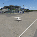
Thanks for downloading Julius Nyerere International Airport (HTDA) Version 2. This is the Largest Airport in Tanzania. The Airport scenery was built from Sketchup, SBUILDER and ADE v1.76 utilizing Google Earth for correct positions. Objects placed with Instant Scenery 3. This is version 2, it includes Terminal 1, Terminal 2, Terminal 3 (underconstruction), VIP trminal, Fire Station and Radar and Control tower in the correct position. and the "correct" afcad. More improvements will come once Terminal 3 is opened . Needs RWY12 Object library.
| Filename: | Julius_Nyerere_International_Airport_V2.zip |
| License: | Freeware |
| Added: | 16th October 2018, 15:36:32 |
| Downloads: | 1,175 |
| Author: | Emmanuel Mwandosya |
| Size: | 102.6 MB |
| Category: Flight Simulator X - Scenery | |
| ENOV-Orsta Volda Hovden v2 |
|
Images related to this file:
File Description:
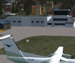
Freeware scenery made by Knudsenair simulations. Scenery is V2 of ENOV in Norway regional pack.
Ørsta–Volda Airport, Hovden (Norwegian: Ørsta–Volda lufthamn, Hovden; IATA: HOV, ICAO: ENOV) is a regional airport situated at Hovden (Hovdebygda), in Ørsta, Norway, midway between the towns of Ørsta and Volda. The airport features a 1,070-meter (3,510 ft) asphalt runway aligned 06/24. Services are provided by Widerøe using their de Havilland Canada Dash 8 as a public service obligation.
| Filename: | ENOVOrsta_Volda_Hovden_v2.zip |
| License: | Freeware |
| Added: | 29th April 2020, 19:17:25 |
| Downloads: | 326 |
| Author: | Knudsenair simulations |
| Size: | 389.98 KB |
| Category: Flight Simulator X - Scenery | |
| LRTZ(Tuzla Airfield) Update + Costinesti Airfield |
|
Images related to this file:
File Description:
This is the new version of Tuzla Airfield with lots of new scenery objects and some new parking spots for a more realistic scenery.
Also included in this update is the Costinesti Airfield located right near the edge of the Black Sea, south of Schitu village. The airport ICAO code is RO12 and in real life it is used for Ultralights and small GA airplanes. There are 3 hangars where you can start the flight from and you have one big grass runway.
| Filename: | LRTZTuzla_Airfield_Update__Costinesti_Airfield.zip |
| License: | Freeware |
| Added: | 27th August 2021, 17:22:01 |
| Downloads: | 131 |
| Author: | Liviu |
| Size: | 180.86 KB |


© 2001-2026 AVSIM Online
All Rights Reserved
Privacy Policy |