
Where Flight Simulation Enthusiasts Gather from Around the World!
AVSIM Library - Search Results

| Category: Flight Simulator 2004 - Scenery | |
| Wilgrove Airpark (8A6) |

|
Images related to this file:
File Description:
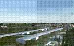
Wilgrove Airpark (8A6) is a small GA airport located just east of Charlotte, NC. It is often forgotten by pilots in Flightsimulator, yet it is a very busy place in the real-world, due to it's huge popularity with student and weekend GA pilots. There has never been a really good, accurate representation of this little gem created for the flightsim, so I decided to try my hand at it. This is my very first scenery project, and I hope you enjoy it. It was designed with ADE9X, and it requires RWY12 and EZ-Scenery objects extensively,(not included) so you will need to download these freeware scenery libraries prior to installation of this package for the Wilgrove Airpark scenery to display properly. - Glenn Mullis
| Filename: | Wilgrove_Airpark_8A6.zip |
| License: | Freeware, limited distribution |
| Added: | 22nd September 2010, 16:59:32 |
| Downloads: | 278 |
| Author: | Glenn Mullis |
| Size: | 4.4 MB |
| Category: Flight Simulator 2004 - Scenery | |
| Taihape Airfield, New Zealand. NZVR. |
|
File Description:
Welcome to Taihape, a small rural airfield in the Rangitikei region of the central North Island of New Zealand.
The airfield is situated 1 nautical mile south-west of the small town of Taihape, and is home to Rangitikei Air Services, and also home to a couple of the Wanganui Aero Work agricultural Fletcher aircraft.
Wanganui Aero work is the largest agricultural aircraft fleet operator in New Zealand.
This scenery is designed specifically for use with the GNZLAP Special AI Release "A Flock of Fletchers",by Charl Du Toit.
This AI package is freely available here on avsim, filename....... GNZLAPA1.zip .
This scenery is REQUIRED for the AI package to work properly. Scenery requires some EZ Scenery Object sets (see INSTALL instructions for details).
| Filename: | Taihape_Airfield_New_Zealand_NZVR.zip |
| License: | Freeware, limited distribution |
| Added: | 6th September 2008, 02:55:22 |
| Downloads: | 787 |
| Author: | Lawrie Roache |
| Size: | 1.42 MB |
| Category: Flight Simulator 2004 - Scenery | |
| Minden-Tahoe Airport (KMEV) |
|
File Description:
The Minden-Tahoe Airport(KMEV) is a 990-acre general aviation non-towered airport. Built in 1942 as a military training base, Douglas County acquired the Airport and has operated it as a municipal airport governed by Douglas County Board of County Commissioners. The Airport serves a broad base of aviation uses from corporate to recreational flying. It is home to approximately 250 aircraft with 80,000 annual operation. It is also home to the Minden Tanker Base and the Sierra Front Dispatch Agency with primary mission of dispatching tankers to fires in the Sierra Nevada region. Scenery created with FSDS3, Rwy12, EZ Scenery, AFCAD2 and Traffic Tools2.x. Your choice of Towered or non-towered AFCAD file. See readme for details.
| Filename: | MindenTahoe_Airport_KMEV.zip |
| License: | Freeware |
| Added: | 2nd February 2006, 03:15:10 |
| Downloads: | 1,014 |
| Author: | John B. Loney, Jr. |
| Size: | 619.94 KB |
| Category: Flight Simulator 2004 - Scenery | |
| Norfolk Island International Airport, YSNF. V-2 ( includes landclass fix). |
|
File Description:
WELKAM TU NORFUK AILEN.
Welcome to Norfolk Island International Airport.
Norfolk Island is a beautiful and popular holiday destination in the Pacific Ocean, between New Zealand and Australia.
Norfolk Air has scheduled flights to and from both Australia and New Zealand to the Island, and the airport is also used as a stepping stone for International GA flights.
This scenery is a total ground-up rebuild of my old YSNF scenery, and as such, requires you delete my older scenery totally from the sim before installing this one. It also contains the landclass fix for Norfolk which turns Microsoft's erronous "Water" island into an island with actual land. Contains a few small custom items (textures included). Requires some EZ Scenery Object Sets ( see INSTALL instructions for details).
| Filename: | Norfolk_Island_International_Airport_YSNF__V2__inc.zip |
| License: | Freeware, limited distribution |
| Added: | 24th April 2009, 23:59:03 |
| Downloads: | 2,310 |
| Author: | Lawrie Roache |
| Size: | 2.65 MB |
| Category: Flight Simulator 2004 - Scenery | |
| Pinal Airpark KMZJ |
|
File Description:
FS2004 Scenery - Pinal Airpark (IATA: MZJ, ICAO: KMZJ) is an airport located in Pinal County, seven miles (11 km) northwest of the central business district (CBD) of Marana, a city in Pima County, Arizona, USA. Its main purpose is to act as a "boneyard" for aircraft. Old airplanes are stored there with the hope that the dry desert climate will prevent rust and other forms of corrosion in case the aircraft is pressed into service in the future. Even so, many aircraft which are brought there wind up being scrapped. Nearby Davis-Monthan Air Force Base provides the same service to the U.S. military. Compatible with both FS default and Ultimate Terrain. EZ Scenery Libraries required. Some included. by JOhn B. Loney, Jr.
| Filename: | Pinal_Airpark_KMZJ.zip |
| License: | Freeware, limited distribution |
| Added: | 16th March 2008, 05:46:41 |
| Downloads: | 1,619 |
| Author: | John B. Loney, Jr. |
| Size: | 7.14 MB |
| Category: Flight Simulator X - Aircraft Repaints, Textures and Modifications | |
| Northeast 'Yellowbird' Boeing 727-200 <p>FS2004/FSX</p> |
|
Images related to this file:
File Description:
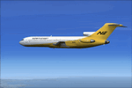
This is a repaint of the TDS 727-200 in the Northeast 'Yellowbird' livery. Northeast flew both the 727-100s and 727-200s. Northeast was a major U.S. carrier with a long history, based in Boston. It was formed in 1931 and was merged into Delta in 1972. This aircraft was tested on FSX-SE only but should work in the boxed FSX and FS2004. You need the TDS 727-200 base pack for this repaint. The textures are 32bit & DXT3.
| Filename: | Northeast_Yellowbird_Boeing_727200_pFS2004FSXp.zip |
| License: | Freeware |
| Added: | 13th February 2017, 04:43:32 |
| Downloads: | 268 |
| Author: | Ted Giana |
| Size: | 9.86 MB |
| Category: Flight Simulator 2004 - Scenery | |
| Hadera 'Orot-Rabin' Power-Plant V2 |
|
File Description:
FS2004 Scenery - Orot-Rabin power plant near Hadera,
Israel (named after the late Israeli prime minister) is located
on the Mediterranean coast between Tel-Aviv and Haifa and
therefore is a well known landmark for VFR pilots. The
power plant is operated with coal and has an output of two
700mw + one 1,400mw turbines. A total of 2,800mw and
a 1,800 meter long unloading pier for coal ships. Made in
gmx. Enhanched with smoke effects and night lighting
for navigation.
| Filename: | Hadera_OrotRabin_PowerPlant_V2.zip |
| License: | Freeware |
| Added: | 18th November 2003, 16:55:19 |
| Downloads: | 6,785 |
| Author: | Seev Kahn |
| Size: | 687.86 KB |
| Category: Flight Simulator 2004 - Scenery | |
| 4AK6 - Wolf Lake - Anchorage, Alaska - USA |
|
Images related to this file:
File Description:
Wolf Lake 4AK6 is in Alaska, some 10 miles northeast of Wasilla, on the north side of Knik Arm. It is an airpark, with houses and hangars adjacent to a runway that is 3,800 feet of asphalt aligned 06-24. The runway is lit but the taxiways are not. There is a second runway that is around 2,500 feet long and aligned 36-18, which is grass and unlit. The C-130 is permanently parked, and seeing it land would have been interesting.
| Filename: | 4AK6__Wolf_Lake__Anchorage_Alaska__USA.zip |
| License: | Freeware, limited distribution |
| Added: | 15th October 2014, 13:38:39 |
| Downloads: | 371 |
| Author: | Roger Wensley |
| Size: | 7.32 MB |
| Category: Flight Simulator X - Scenery | |
| YMBE Mooliabeenie Siding, Western Australia (closed) |
|
File Description:
YMBE Mooliabeenie Siding is a disused 1,500 m (4,900 ft) long satelite airstrip which was used by the United States Army Air Corps during World War II and associated with the Caversham Airfield at Middle Swan. Like the Caversham Airfield, the Mooliabeenee Airfield was later used an auto racetrack. Local car clubs regularly use the site for motorkhana events. REQUIRES Blencowe_LibraryKit.zip
REQUIRES blencowe_librarykit_309494.zip (Available HERE)
| Filename: | YMBE_Mooliabeenie_Siding_Western_Australia_closed.zip |
| License: | Freeware |
| Added: | 28th February 2013, 13:56:01 |
| Downloads: | 195 |
| Author: | Alan Blencowe |
| Size: | 5.98 MB |
| Category: Flight Simulator X - Scenery | |
| San Giovanni Rotondo Puglia Italy Coordinate N 41°42 'E 15° 44' |
|
File Description:
San Giovanni Rotondo is an Italian municipality in the province of Foggia in Puglia Italy, rises 1256m above the
promontory of El Gargano, famous in the world for hosting the remains of St. Pius by Pietrelcina, cappuccino friar who
lived long in the homonym city. Geographic coordinates N 41° 42 'E 15° 44'. The scenery is an important VFR point at
1256m for those who want to fly over the Gargano. Within the package you will find instructions for installing the scenery.
| Filename: | San_Giovanni_Rotondo_Puglia_Italy_Coordinate_N_414.zip |
| License: | Freeware |
| Added: | 2nd September 2017, 18:12:17 |
| Downloads: | 369 |
| Author: | Pasquale Marrulli |
| Size: | 1.71 KB |
© 2001-2026 AVSIM Online
All Rights Reserved
Privacy Policy |