
Where Flight Simulation Enthusiasts Gather from Around the World!
AVSIM Library - Search Results

| Category: Flight Simulator 2004 - AI Aircraft | |
| World of AI South East Asian Airlines Complete AI Package |

|
Images related to this file:
File Description:

World of AI welcomes you to this South East Asian Airlines Complete AI Package for FS2004 and FSX. Models by Juan Sebastian Gonzales, Viktor Schacht; Repaints by Symon Long, Dieter Barthelmeus; Winter 2008 flightplans by Stephen Croft / Alpha-India Group. IMPORTANT! You need the World of AI Installer to make this package work! (WOAINS24.zip). This package just replaces the corrupted package due to the AVSIM hack. Nothing has changed.
| Filename: | World_of_AI_South_East_Asian_Airlines_Complete_AI_.zip |
| License: | Freeware, limited distribution |
| Added: | 1st February 2010, 09:55:31 |
| Downloads: | 44,310 |
| Author: | World of AI |
| Size: | 1.31 MB |
| Category: Flight Simulator 2004 - Original Aircraft | |
| NWA (Mesaba), Bombardier CRJ-900, v3 |
|
Images related to this file:
File Description:
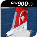
The Project Open Sky team now presents our long awaited version 3 of our CRJ-900! Built mainly for FS2004 (FSX not fully tested, see our support forums at http://www.projectopensky.com), some of it's features include; highly detailed textures & night textures, realistic lighting effects, dynamic wing flex with XML coding, XML coded nose gear steering with steering lock at high rolling speed, fully independent XML landing gear suspension, wingviews (No VC), and much more! Enjoy!
| Filename: | NWA_Mesaba_Bombardier_CRJ900_v3.zip |
| License: | Freeware |
| Added: | 3rd February 2010, 18:57:57 |
| Downloads: | 2,080 |
| Author: | AJ Nikoley, Project Open Sky |
| Size: | 11.95 MB |
| Category: Civil Flight Simulators - Looking Glass Flight Unlimited 3 | |
| Boeing 747-400 Excalibur |
|
Images related to this file:
File Description:
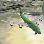
This package will transform the outstanding Boeing 747-400 to "Excalibur flight 522 heavy", with proper livery and call sign. Now you can fly those long routes in professional style! Since the B747 is very big (both in real life and as FU3 RES file), only the changed parts are in this package. Detailed instructions and ResViewer script are included.This file needs Resviewer 1.32 and Boeing 747-400 ver. 1.13 in addition for use.
| Filename: | Boeing_747400_Excalibur.zip |
| License: | Freeware |
| Added: | 15th February 2010, 11:01:11 |
| Downloads: | 757 |
| Author: | Jouko Huovinen |
| Size: | 277.7 KB |
| Category: Navigation and ATC - Navigation | |
| Green Bay Sectional Chart Chunks for Aerosoft's FSMap |
|
File Description:
Sectional chart chunks made from the August 2009 Sectional charts at the original scale, formatted in the WGS84 lat/long geographic coordinate system for the FSMap, moving map application for flight simulation use. The chart chunks are the full sectional divided by 2 tiles (east/west) and converted to baseline 8bit tiffs with packbits compression applied. The images average 6,000x6,000 pixels at about 25mb each, also included is the FSMap fsm Calibration file for importing.
| Filename: | Green_Bay_Sectional_Chart_Chunks_for_Aerosofts_FSM.zip |
| License: | Freeware |
| Added: | 22nd March 2010, 20:40:23 |
| Downloads: | 326 |
| Author: | David Myers |
| Size: | 28.25 MB |
| Category: Navigation and ATC - Navigation | |
| Chicago Sectional Chart Chunks for Aerosoft's FSMap |
|
File Description:
Sectional chart chunks made from the August 2009 Sectional charts at the original scale, formatted in the WGS84 lat/long geographic coordinate system for the FSMap, moving map application for flight simulation use. The chart chunks are the full sectional divided by 2 tiles (east/west) and converted to baseline 8bit tiffs with packbits compression applied. The images average 6,000x6,000 pixels at about 25mb each, also included is the FSMap fsm Calibration file for importing.
| Filename: | Chicago_Sectional_Chart_Chunks_for_Aerosofts_FSMap.zip |
| License: | Freeware |
| Added: | 22nd March 2010, 20:40:31 |
| Downloads: | 516 |
| Author: | David Myers |
| Size: | 31.9 MB |
| Category: Navigation and ATC - Navigation | |
| Lake Huron Sectional Chart Chunks for Aerosoft's FSMap |
|
File Description:
Sectional chart chunks made from the August 2009 Sectional charts at the original scale, formatted in the WGS84 lat/long geographic coordinate system for the FSMap, moving map application for flight simulation use. The chart chunks are the full sectional divided by 2 tiles (east/west) and converted to baseline 8bit tiffs with packbits compression applied. The images average 6,000x6,000 pixels at about 25mb each, also included is the FSMap fsm Calibration file for importing.
| Filename: | Lake_Huron_Sectional_Chart_Chunks_for_Aerosofts_FS.zip |
| License: | Freeware |
| Added: | 22nd March 2010, 20:40:41 |
| Downloads: | 337 |
| Author: | David Myers |
| Size: | 32.26 MB |
| Category: Navigation and ATC - Navigation | |
| Detroit Sectional Chart Chunks for Aerosoft's FSMap |
|
File Description:
Sectional chart chunks made from the August 2009 Sectional charts at the original scale, formatted in the WGS84 lat/long geographic coordinate system for the FSMap, moving map application for flight simulation use. The chart chunks are the full sectional divided by 2 tiles (east/west) and converted to baseline 8bit tiffs with packbits compression applied. The images average 6,000x6,000 pixels at about 25mb each, also included is the FSMap fsm Calibration file for importing.
| Filename: | Detroit_Sectional_Chart_Chunks_for_Aerosofts_FSMap.zip |
| License: | Freeware |
| Added: | 22nd March 2010, 20:40:50 |
| Downloads: | 390 |
| Author: | David Myers |
| Size: | 33.56 MB |
| Category: Navigation and ATC - Navigation | |
| Montreal Sectional Chart Chunks for Aerosoft's FSMap |
|
File Description:
Sectional chart chunks made from the August 2009 Sectional charts at the original scale, formatted in the WGS84 lat/long geographic coordinate system for the FSMap, moving map application for flight simulation use. The chart chunks are the full sectional divided by 2 tiles (east/west) and converted to baseline 8bit tiffs with packbits compression applied. The images average 6,000x6,000 pixels at about 25mb each, also included is the FSMap fsm Calibration file for importing.
| Filename: | Montreal_Sectional_Chart_Chunks_for_Aerosofts_FSMa.zip |
| License: | Freeware |
| Added: | 22nd March 2010, 20:40:58 |
| Downloads: | 436 |
| Author: | David Myers |
| Size: | 35.53 MB |
| Category: Navigation and ATC - Navigation | |
| New York Sectional Chart Chunks for Aerosoft's FSMap |
|
File Description:
Sectional chart chunks made from the August 2009 Sectional charts at the original scale, formatted in the WGS84 lat/long geographic coordinate system for the FSMap, moving map application for flight simulation use. The chart chunks are the full sectional divided by 2 tiles (east/west) and converted to baseline 8bit tiffs with packbits compression applied. The images average 6,000x6,000 pixels at about 25mb each, also included is the FSMap fsm Calibration file for importing.
| Filename: | New_York_Sectional_Chart_Chunks_for_Aerosofts_FSMa.zip |
| License: | Freeware |
| Added: | 22nd March 2010, 20:56:39 |
| Downloads: | 528 |
| Author: | David Myers |
| Size: | 34.43 MB |
| Category: Navigation and ATC - Navigation | |
| Halifax Sectional Chart Chunks for Aerosoft's FSMap |
|
File Description:
Sectional chart chunks made from the August 2009 Sectional charts at the original scale, formatted in the WGS84 lat/long geographic coordinate system for the FSMap, moving map application for flight simulation use. The chart chunks are the full sectional divided by 2 tiles (east/west) and converted to baseline 8bit tiffs with packbits compression applied. The images average 6,000x6,000 pixels at about 25mb each, also included is the FSMap fsm Calibration file for importing.
| Filename: | Halifax_Sectional_Chart_Chunks_for_Aerosofts_FSMap.zip |
| License: | Freeware |
| Added: | 22nd March 2010, 22:27:02 |
| Downloads: | 362 |
| Author: | David Myers |
| Size: | 29.08 MB |


© 2001-2026 AVSIM Online
All Rights Reserved
Privacy Policy |