
Where Flight Simulation Enthusiasts Gather from Around the World!
AVSIM Library - Search Results

| Category: Flight Simulator 2004 - Scenery | |
| Hall Beach CYUX in Nunavut, Canada |

|
Images related to this file:
File Description:
Hall Beach is on the Melville Peninsula, part of the mainland of Canada, south and west of Baffin Island. It is around 40 miles south of Igloolik and 50 miles west of Rowley, both of them my previous posts. The airfield was built to support the construction and operation of a main DEW line radar station and to support the rest of the associated chain. Because of the employment opportunities this brought, a village developed nearby. The airfield continues in regular use and the runway, though still gravel, is 5,400' long and 150' wide and lighted; the alignment is 124T and 304T as this is in northern domestic airspace and bearings are given as 'true" and not "magnetic". There are scenery folders for the village, roads, grass, etc, and AI for two airlines with regular service to Hall Beach.
| Filename: | Hall_Beach_CYUX_in_Nunavut_Canada.zip |
| License: | Freeware, limited distribution |
| Added: | 22nd November 2011, 14:33:08 |
| Downloads: | 456 |
| Author: | Roger Wensley |
| Size: | 3.83 MB |
| Category: Flight Simulator X - Utilities | |
| Landing Parameters for FSX and P3D |
|
Images related to this file:
File Description:
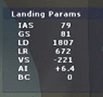
Landing_Params is a Lua script for FSX/P3D that displays landing parameters in a small text window that pops
up after the aircraft has landed and has reached taxi speed. The script should be activated with a key or button (like the gear
down key/button) during the approach to landing. Parameters displayed in the window after touchdown are
Indicated Airspeed (IAS, Kts), Ground Speed (GS, Kts), Landing Distance (LD, ft), Landing Roll (LR, ft), Vertical
Speed (VS, ft/min), Attitude Indicator pitch at touchdown (AI), and Bounce Count (BC). Data collection begins
when the a/c passes through a radar altimeter determined threshold altitude window between 45 and 55 ft
(i.e., the nominal 50ft threshold height). In addition, more detailed landing parameter information may be
logged. A registered copy of FSUIPC is required to execute the Lua script.
| Filename: | Landing_Parameters_for_FSX_and_P3D.zip |
| License: | Freeware |
| Added: | 18th February 2018, 04:09:32 |
| Downloads: | 568 |
| Author: | Al Klayton |
| Size: | 164.08 KB |
| Category: Flight Simulator 2004 - Scenery | |
| Alaska North Slope 3: Atqasuk (PATQ) |
|
Images related to this file:
File Description:
The town of Barrow is in the far north of Alaska, and these are coastal villages or radar installations to the west and south of Barrow. There will be further additions. Atqasuk PATQ is 55 miles south of Barrow and is unusual in that it is one of the few settlements of the North Slope that is not on the coast. It is, however, on a narrow winding river that reaches the sea to the east of Barrow and seemingly provides fish in abundance. There could well be other good reasons for the village to be where it is, but they are unknown to me. The population is around 250. The airfield is to the south of the village and the runway is 4,900 feet of gravel aligned 06-24, lit, and with PAPI at each end.
| Filename: | Alaska_North_Slope_3_Atqasuk_PATQ.zip |
| License: | Freeware, limited distribution |
| Added: | 17th June 2016, 08:54:55 |
| Downloads: | 233 |
| Author: | Roger Wensley |
| Size: | 2.35 MB |
| Category: Flight Simulator X - Panels | |
| FSX Glass Cockpit Mini Panel |
|
Images related to this file:
File Description:
FSX Glass Cockpit Mini Panel that many of you requested is intended to replace the global default minipanel or my previous analog mini panel. The mini panel is made up of freeware Glass Cockpit LCD instruments. This gives the pilot a common set of LCD gauges to use on multiple aircraft. Many pop-up windows available to keep the main mini panel uncluttered. Additional navigation and control surfaces gauges are provided. Information is provided for wind direction, drift, ETA, ETE, direction, distance and name of the nearest airport; direction and distance to the next waypoint set in the GPS; and radar/absolute altitude. Karol Chlebowski�s TFR gauge is included that allow flight at extremely low altitudes. Also included is Dietmar Loleit new TCAS gauge for FSX. Extensive tooltips have been provided on most gauges.
| Filename: | FSX_Glass_Cockpit_Mini_Panel.zip |
| License: | Freeware |
| Added: | 21st September 2010, 21:39:33 |
| Downloads: | 1,222 |
| Author: | Bill McClellan |
| Size: | 4.61 MB |
| Category: Flight Simulator 2004 - Scenery | |
| EDDB Berlin Brandenburg Airport 2012 |
|
Images related to this file:
File Description:
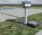
This is an update of my FS2004 freeware scenery for EDDB, BER (former
Berlin Schoenefeld after its extension to Berlin Brandenburg Airport).
Changes:
- Updated taxiway and apron positions according to AIP docs I got
in 2012 (thanks to Benjamin).
- Updated ILS (has DME) and approach routes with official waypoints taken from
this docs.
- Remove of EDDT and EDDI (EDDI already closed, EDDT should be closed 2012/6/3).
- Rebuild the old GAT area (the planned cargo area there isn't built yet),
updated layout as everything is built by now.
- New tower and SMR (Surface Movement Radar) towers.
- Corrects small errors (taxi labels, lines, lights).
- Parking spots at apron E.
- Modified colours of pier buildings.
Gernot Zander, [email protected], 2006-08-07, 2011-09-20, 2012-05-01
| Filename: | EDDB_Berlin_Brandenburg_Airport_2012.zip |
| License: | Freeware |
| Added: | 6th May 2012, 23:47:08 |
| Downloads: | 4,833 |
| Author: | Gernot Zander |
| Size: | 4.82 MB |
| Category: Flight Simulator X - Scenery Design | |
| SLLP El Alto Intl. Airport LA PAZ Bolivia FSX |
|
File Description:
¿Do you want to know what is like to take off and land in a high altitude airport?
SLLP LA PAZ Airport is waiting you!
We added some fictional buildings to this airport; was built with fsx elements (acceleration pack) so no more textures will be needed
than the lights and the radar whose credits have been indicated inside the delivery.
The city environment, taxiways, terminal, the hangar yards and scrap yards have been improved,
the approach points have been controlled according to the air navigation charts, adding D5.5 PAZ for SID.
It has two cargo parking, gates, jetways, and ramps for smaller aircraft etc.
It has a fixed and transported fuel service, as well as mobile jetways by default, pushback service,
and an environment suitable for the large area of this large Latin American airport. Aero charts included.
Enjoy it!
| Filename: | SLLP_El_Alto_Intl_Airport_LA_PAZ_Bolivia_FSX.zip |
| License: | Freeware |
| Added: | 6th December 2020, 23:50:55 |
| Downloads: | 1,845 |
| Author: | Cristóbal Laje Ros |
| Size: | 28.88 MB |
| Category: Flight Simulator X - Panels | |
| Boeing 767 |
|
File Description:
FSX Boeing B767 Panel. This comes from an old FS98 panel by Eric Ernst which is one of the best jobs I have seen, even better than many so-called "realistic" panels for later FS releases. Since I greatly missed this panel, then I have reworked it for FSX. All gauges react to panel lights and avionics buses, making it great to flight at night. Also features no-smoking/fasten-seat belts signs, plus tape sliding radar altimeter, regulable seat position and animated yoke. Last but not least, I have included the whole gauges source code under GPL (gauge programmers will love this!). Gauges programmed with an eye towards frame rate. This new version features reworked HSI (arc/rose), reworked autobrake and gauge switches sound. By Alessandro Antonini, author of Super Flight Planner. Older FS2004 version is still available on avsim.com and cpinf.com
| Filename: | Boeing_767.zip |
| License: | Freeware |
| Added: | 9th September 2007, 19:06:47 |
| Downloads: | 19,082 |
| Author: | Alessandro Antonini |
| Size: | 1.02 MB |
| Category: Flight Simulator X - Scenery | |
| EDDB Berlin Brandenburg Airport 2011 |
|
Images related to this file:
File Description:

This is an update of my FSX freeware scenery for EDDB, BER (former
Berlin Schoenefeld after its extension to Berlin Brandenburg Airport).
Changes:
- Updated taxiway and apron positions according to AIP docs I got
in 2012 (thanks to Benjamin).
- Updated ILS (has DME) and approach routes with official waypoints taken from
this docs.
- Remove of EDDT and EDDI (EDDI already closed, EDDT should be closed 2012/6/3).
- Rebuild the old GAT area (the planned cargo area there isn't built yet),
updated layout as everything is built by now.
- New tower and SMR (Surface Movement Radar) towers.
- Corrects small errors (taxi labels, lines, lights).
- Parking spots at apron E.
- Modified colours of pier buildings.
Gernot Zander, [email protected], 2006-08-07, 2011-09-20, 2012-05-01
| Filename: | EDDB_Berlin_Brandenburg_Airport_2011.zip |
| License: | Freeware |
| Added: | 6th May 2012, 23:57:24 |
| Downloads: | 15,033 |
| Author: | Gernot Zander |
| Size: | 4.75 MB |
| Category: Microsoft Flight Simulator (2020) - Utilities | |
| FSTramp v8.84 for MSFS, FSX(-SE), Prepart3D, X-Plane (Win) |
|
Images related to this file:
File Description:

This add-on is an EXE application for Microsoft Flight Simulator and a DLL module for all other simulators. The DLL variant is activated via hotkeys or the simulator menu add-ons or plugins. Window size and layout are configurable for one or more screens. To avoid dazzling, the brightness of the entire application is customizable. Primarily it is a flight management system (FMS) with automatic control from start to landing. This also includes the observance of SID, STAR and Approaches in unmatched quality. The flight plan required for the FMS can be created manually or automatically, interactive changes and additions during the flight are possible. The basis of the flight planner is the 3D world map and the search function for airfields and navigation aids. The FMS by FSTramp relies on the autopilot of the aircraft. In case of incompatibility, the autopilot integrated in FSTramp will be used. This allows FSTramp to control almost all aircraft from airport to airport. The altitude profile of the flight plan, SID, STAR and approach is taken into account. This means that FSTramp extends the often incomplete airport procedures to and from the runway so that they can be flown completely automatically. During the fully automatic flight, the autopilot values ​​for HDG, ALT, VSPEED, SPD and MACH can be manually overridden. This is e.g. useful for being able to react to the instructions of the tower in the final approach without completely stopping the automatic flight. The rotating or north pointing 3D world map with numeric display of the terrain elevation under the mouse arrow is another special feature. It does not need an internet but is synthesized from included height profiles of the globe. The Data of continents, mountains and rivers are included in the setup. Airspaces, Airways, Waypoints and SID, STAR and Approaches are also included in the setup, but can be updated by installing additional AIRAC cycles. Airfields and navigation stations are taken from the simulator. NVIDIA: If the frame rate of the simulator drops sharply about 20 seconds after FSTramp's visibility, the power management of the GPU slows down prematurely. In the NVIDIA Control Panel, change the 'Manage 3D settings - Power management mode' option to 'Adaptive'.
| Filename: | FSTramp_v884_for_MSFS_FSXSE_Prepart3D_XPlane_Win.zip |
| License: | Shareware, time limited |
| Added: | 7th July 2023, 04:35:12 |
| Downloads: | 110 |
| Author: | Helge Schroeder |
| Size: | 358.21 MB |
| Category: Flight Simulator X - Utilities | |
| FSTramp v8.84 for MSFS, FSX(-SE), Prepart3D, X-Plane (Win) |
|
Images related to this file:
File Description:
This add-on is an EXE application for Microsoft Flight Simulator and a DLL module for all other simulators. The DLL variant is activated via hotkeys or the simulator menu add-ons or plugins. Window size and layout are configurable for one or more screens. To avoid dazzling, the brightness of the entire application is customizable. Primarily it is a flight management system (FMS) with automatic control from start to landing. This also includes the observance of SID, STAR and Approaches in unmatched quality. The flight plan required for the FMS can be created manually or automatically, interactive changes and additions during the flight are possible. The basis of the flight planner is the 3D world map and the search function for airfields and navigation aids. The FMS by FSTramp relies on the autopilot of the aircraft. In case of incompatibility, the autopilot integrated in FSTramp will be used. This allows FSTramp to control almost all aircraft from airport to airport. The altitude profile of the flight plan, SID, STAR and approach is taken into account. This means that FSTramp extends the often incomplete airport procedures to and from the runway so that they can be flown completely automatically. During the fully automatic flight, the autopilot values ​​for HDG, ALT, VSPEED, SPD and MACH can be manually overridden. This is e.g. useful for being able to react to the instructions of the tower in the final approach without completely stopping the automatic flight. The rotating or north pointing 3D world map with numeric display of the terrain elevation under the mouse arrow is another special feature. It does not need an internet but is synthesized from included height profiles of the globe. The Data of continents, mountains and rivers are included in the setup. Airspaces, Airways, Waypoints and SID, STAR and Approaches are also included in the setup, but can be updated by installing additional AIRAC cycles. Airfields and navigation stations are taken from the simulator. NVIDIA: If the frame rate of the simulator drops sharply about 20 seconds after FSTramp's visibility, the power management of the GPU slows down prematurely. In the NVIDIA Control Panel, change the 'Manage 3D settings - Power management mode' option to 'Adaptive'.
| Filename: | FSTramp_v884_for_MSFS_FSXSE_Prepart3D_XPlane_Win.zip |
| License: | Shareware, time limited |
| Added: | 7th July 2023, 04:35:43 |
| Downloads: | 130 |
| Author: | Helge Schroeder |
| Size: | 358.21 MB |
© 2001-2026 AVSIM Online
All Rights Reserved
Privacy Policy |