
Where Flight Simulation Enthusiasts Gather from Around the World!
AVSIM Library - Search Results

| Category: Flight Simulator 2004 - Scenery | |
| LFBT Tarbes/Lourdes-Pyrenees, France |

|
Images related to this file:
File Description:
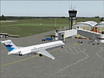
Googly scenery for LFBT Tarbes - a normally quiet airport that just sees a few
domestic flights a day but bursts into life for those of the the Catholic faith to
participate in the pilgrimage to Lourdes. At these times it is served by a
regular stream of charter flights and the airport can handle aircraft as large
as the Boeing 747. The only scheduled flights are between here and Paris, normally operated by Canadair CRJ700 craft worked by Brittany Air International on behalf of Air France, but a huge range of charter operators - mostly from Italy, Ireland, Belgium, the
United Kingdom and Germany - may be seen here at times and although seasonal this
traffic represents 80% of the airport's entire annual activity.
The scenery does not purport to be ultra-accurate. Based on less-than-perfect
satellite imagery from Google Earth, the layout is proportionally correct but the
added airport features, such as buildings, are built from default Microsoft objects
and add-on libraries so will not look exactly like the real thing. You are not obliged to download and install any additional scenery libraries, but to enjoy this scenery in its entirety, you may wish to. It will work fine, with or without.
[File re-uploaded at the request of AVSIM]
| Filename: | LFBT_TarbesLourdesPyrenees_France.zip |
| License: | Freeware |
| Added: | 4th May 2010, 15:02:30 |
| Downloads: | 7,811 |
| Author: | John Hinson |
| Size: | 73 KB |
| Category: Flight Simulator 2004 - Scenery | |
| Cape Verde Islands Domestic Airports |
|
Images related to this file:
File Description:
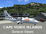
Googlyafcads and simple scenery for five airports in the Cape Verde Islands, all
of which are served by regular domestic flights of TACV - Transportes Aereos de
Cabo Verde. Each of these has been "overlooked" by Microsoft in Flight Simulator
2004 and are provided with nothing other than a runway. These scenery files add
aprons, taxiways, buildings and other airport features to Flight Simulator's bland
representation and allow you and "AI" traffic to land, taxi, park and take off
in a realistic manner.
The airports represented are: GVBA Rabil, GVMA Maio, GVSF Sao Filipe, GVSN Preguica and GVSV Sao Pedro.
The scenery does not purport to be ultra-accurate. Based on high-detail satellite
imagery from Google Earth (except Sao Filipe), the layout is proportianally correct
but the added airport features, such as buildings, are built from default Microsoft
objects and add-on libraries so will not look like the real thing. Sao Filipe is
largely imaginary owing to poor quality of the satellite image, but has been created
to be similar to other airports of like size.
You are not obliged to download and install any additional scenery libraries,
but to enjoy this scenery in its entirety, you may wish to. It will work fine,
with or without.
[File re-uploaded at request of AVSIM]
| Filename: | Cape_Verde_Islands_Domestic_Airports.zip |
| License: | Freeware |
| Added: | 15th June 2010, 01:00:46 |
| Downloads: | 6,997 |
| Author: | John Hinson |
| Size: | 84.1 KB |
| Category: Flight Simulator 2004 - Scenery | |
| SSJA Joaçaba, Brazil |
|
Images related to this file:
File Description:
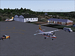
Googly scenery for SSJA Joaçaba - a small domestic airport
in the state of Santa Caterina, Brazil, that is poorly provided for in Flight
Simulator 2004. These scenery files add taxiways, aprons, buildings and other
airport features, so that you and your "AI" traffic can land, taxi, park and
take off in a realistic manner.
The small but prosperous city of Joaçaba was originally established in 1917 as
Cruzeiro and later known as Limeira and Cruzeiro do Sol, but in 1943 adopted
the current name following the introduction of legislation prohibiting cities
in Brazil using the same name - not a bad idea really. Joaçaba has a high
quality medical centre serving the state of Santa Caterina and a renowned
university which both bring traffic to the airport which is served by mainly
by LET410 aircraft of local airline NHT Linhas Aéreas.
The scenery does not purport to be ultra-accurate. Based on high-detail satellite
imagery from Google Earth, the layout is proportionally correct but the added
airport features, such as buildings, are built from default Microsoft objects
and add-on libraries so will not look exactly like the real thing.
[File re-uploaded at request of AVSIM]
| Filename: | SSJA_Joaccedilaba_Brazil.zip |
| License: | Freeware |
| Added: | 14th May 2010, 04:47:22 |
| Downloads: | 1,263 |
| Author: | John Hinson |
| Size: | 65.83 KB |
| Category: Flight Simulator 2004 - Scenery | |
| VGEG Chittagong/Shah Amanat International, Bangladesh |
|
Images related to this file:
File Description:

Googly scenery for VGEG Chittagong/Shah Amanat International (known as M A
Hannan until 2005) - an important airport in Bangladesh that is poorly provided
for in Flight Simulator 2004. These scenery files add taxiways, aprons,
buildings and other airport features, including the military area at the north
end and the general aviation ramps, so that you and your "AI" traffic can land,
taxi, park and take off in a realistic manner.
The city of Chittagong and its port are served regularly by jets ranging in size
from the Fokker 28 to the Douglas DC10 from operators like Air Arabia, Air Asia,
Biman Bangladesh Airlines, Oman Air, Thai Airways International, and turboprops of
GMG Airlines, United Airways and Zoom Airways.
The scenery does not purport to be ultra-accurate. Based on high-detail satellite
imagery from Google Earth, the layout is proportionally correct but the added
airport features, such as buildings, are built from default Microsoft objects
and add-on libraries so will not look like the real thing.
You are not obliged to download and install any additional scenery libraries,
but to enjoy this scenery in its entirety, you may wish to. It will work fine,
with or without.
[File re-uploaded at request of AVSIM]
| Filename: | VGEG_ChittagongShah_Amanat_International_Banglades.zip |
| License: | Freeware |
| Added: | 14th May 2010, 05:10:02 |
| Downloads: | 3,079 |
| Author: | John Hinson |
| Size: | 71.7 KB |
| Category: Flight Simulator 2004 - Aircraft Repaints, Textures and Modifications | |
| FS2004/X PIA 747-367 AP-BFY "Ziarat" |
|
Images related to this file:
File Description:
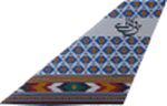
Pakistan International Airlines (PIA) B747-367 Megatop Jumbo, AP-BFY, titled "Ziarat - The City of Flowers". This aircraft, delivered to PIA in 1999, was previously B-HOM for Cathay Pacific Airways. Contains photoreal tail, accurately placed titles and door surround repainted to match the actual airplane. Engines repainted with large yellow stickers on the left side of the casing to match the actual airplane. Being a later model 747, unlike PIA's other 747s, AP-BFY is one without the HF wingtip antennas and a different style wing root and the relevant model has been included. Repainted on the stunning Project Opensky 747v4 Advanced model, with all updates till March 2010. Contains ground service vehicles, stairs,tow truck, catering trucks, luggage loaders and containers painted in standard PIA colors. Luggage containers specially repainted to give a more realistic look. Registration of the aircraft painted on the bottom of the left wing, as on the real airplane. Panel updated to include utility gauge and tow truck gauge. Updated model and fde. Complete pack,requires no external downloads. Textures in high quality 32 bit format to conserve quality. NOT tested in FSX, but should work fine. Repaint by Irfan Khan & Ahmed Ahsen, exclusively from Virtual PIA (WWW.VPIA.ORG)
| Filename: | FS2004X_PIA_747367_APBFY_Ziarat.zip |
| License: | Freeware, limited distribution |
| Added: | 25th March 2010, 18:29:43 |
| Downloads: | 427 |
| Author: | Ahmed Ahsen / Irfan Khan(Virtual PIA/WWW.VPIA.ORG) |
| Size: | 16.42 MB |
| Category: Flight Simulator X - AFCAD Files | |
| Layton's Airfield (28NJ), NJ |
|
File Description:
Layton's Field perhaps no longer exists in actual aviation databases - it's not, for example, listed over at skyvector.com. But you can find it via a Google search. It is coded 28NJ within FSX, although the real 28NJ is a heliport at the Taj Mahal in Atlantic City. It is a single grass turf strip 1692 feet in length and 60 feet wide. There are no services or parking available - if you want to practice touch and go turf landings that's about the extent of the usefulness of this airport. Even if you never use it, this will at least prevent you from flying over the location and seeing a default 3000 foot grass strip (with threshold markings, no less) sticking oddly out amongst the rest of the scenery.
Scenery constructed with use of satellite images/streetview, the author has not been there in person.
This scenery is meant to be used in conjunction with MegaScenery Earth New Jersey/Delaware 004. It is not required, but apron use is minimized to allow satellite scenery to show through as much as possible, and objects are placed based on the MSE textures - lack of it may make scenery look out of place.
| Filename: | Laytons_Airfield_28NJ_NJ.zip |
| License: | Freeware |
| Added: | 11th October 2010, 08:29:30 |
| Downloads: | 206 |
| Author: | Drew Sikora |
| Size: | 327.04 KB |
| Category: Flight Simulator X - AFCAD Files | |
| Bridgeport-Cahill Field Airport (6NJ9), NJ |
|
File Description:
Located 01 miles SW of Bridgeport, New Jersey on 167 acres of land, this airport is non-existent in real life, as far as I am able to determine. although it is still listed as Active, no visible trace of anything remotely suitable for a landing strip is visible anywhere in this area. The strip mining operation nearby in some satellite/aerial photos shows a long narrow grass strip that could be used as a runway, but then others show it stripped down to bare dirt as part of the apparent mining operation, and the MegaSceneryEarth textures depict this latter representation as well. So I have simply removed visible evidence of this strip, although FSX will still try to tell you it's there in the airport directory.
Scenery constructed with use of satellite images/streetview/aerial photos - the author has not been there in person.
This scenery is meant to be used in conjunction with MegaScenery Earth New Jersey/Delaware 004. It is not required, but apron use is minimized to allow satellite scenery to show through as much as possible, and objects are placed based on the MSE textures - lack of it may make scenery look out of place.
| Filename: | BridgeportCahill_Field_Airport_6NJ9_NJ.zip |
| License: | Freeware |
| Added: | 10th February 2011, 05:01:38 |
| Downloads: | 197 |
| Author: | Drew Sikora |
| Size: | 209.8 KB |
| Category: Flight Simulator X - AFCAD Files | |
| LFRV Meucon-Vannes |
|
File Description:
Vannes-Meucon Airport is a regional airport in France (IATA: VNE, ICAO: LFRV). It supports general aviation with no commercial airline service scheduled.
Summary of Changes:
Realigned runway 9/27 to runway 8/26 (as it is in real life). Note that in FSX although this runway is not closed, ATC will never assign this runway, as it is a grass strip, and ATC prefers the asphalt 4/22 instead. IRL 4/22 is actually 3/21 but I couldn't realign this runway, as it has a localiser approach which can't be removed or moved in ADE
Added taxiways B+D to allow traffic to taxi to/from the end of runway 22 via runway 8/26 without causing pileups. Whilst not completely accurate, its very close.
Added fuel trucks to top end of apron, (on the charts this area is designated as a hangar, I chose not to include this, as the FSX hangars look rubbish) Note that only 1 fuel truck moves at a time.
Added a few extra parking spaces. I dislike the method of using every free space for parking, so I have only included parking where LFRV really has designated parking. The airport now has 11 GA parking spaces small-medium.
| Filename: | LFRV_MeuconVannes.zip |
| License: | Freeware, limited distribution |
| Added: | 20th November 2011, 00:26:06 |
| Downloads: | 326 |
| Author: | Martin Joy |
| Size: | 5.89 KB |
| Category: Flight Simulator 2004 - Aircraft Repaints, Textures and Modifications | |
| Roman Abramovich Private Boeing 767-33A/ER (P4-MES) |
|
Images related to this file:
File Description:
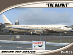
I am proud to present this SkySpirit 2010 V5 model of the Boeing 767-33A/ER owned by billionaire Roman Abramovich. This aircraft bears the Aruban registration P4-MES, and was nicknamed "The Bandit" because of the mask painted around the cockpit windows. This is one of the largest aircraft owned and used by a private individual. It is operated for its owner by Global Jet Luxembourg, callsign "Silver Arrows." This livery is quite elegant and understated for such a "go big" owner. Although flight plans for this aircraft are hard to come by as its registration is blocked when in flight, it makes regular, frequent appearances in Innsbruck (LOWI) and St. Maarten (TNCM). It also shows up at many destinations outside Russia including; Stansted(EGSS), Vienna (LOWW) and Zurich (LSZH). In case you are curious, Roman Abramovich himself is in the captain's seat on this repaint. I tried to make this repaint as accurate as possible. However, the satellite system on the real P4-MES is not representable on this model. The repainted textures in this package are 32-bit with no mipmaps for best clarity and quality. This is a complete install. This package contains SkySpirit2010 B767-300 V5 model, air and config files. The sound is from the default 737.
| Filename: | Roman_Abramovich_Private_Boeing_76733AER_P4MES.zip |
| License: | Freeware, limited distribution |
| Added: | 4th October 2011, 05:20:16 |
| Downloads: | 1,583 |
| Author: | Jeffrey S. Bryner, SkySpirit2010 |
| Size: | 12.33 MB |
| Category: Flight Simulator X - Aircraft Repaints, Textures and Modifications | |
| Exterior Enhancement Pack for the 737-700 NGX |
|
Images related to this file:
File Description:
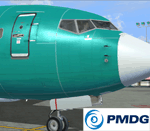
**Revised March 20th 2012** After a lot of positive feedback from forum members, and some very constructive pointers and photos from Ryan (aka Tabs), I've revised the bumps to be a bit closer to a real-world appearance. So if you prefer a more exaggerated appearance (deeper lines, higher rivets) you may prefer the first set over this revision. A completely new set of spec files (for shine and reflection) and bump maps (for surface detail) to update the exterior of your PMDG 737-700 NGX. They can be used over any existing livery for the -700 model. The bump files are in 4096 res (default is 1024) so they will use more memory, but have no noticeable effect on performance on my low-end core2 duo system aside from a slightly longer loading time. The package includes two folders; one for the specular files and the other for the bump maps. Simply drop them into the aircraft texture of your choice and you're ready to fly. More detailed instructions for installation are included. The PMDG NGX base pack and 600/700 model expansion are required. Additional before and after photos are posted in the PMDG NGX support forum.
| Filename: | Exterior_Enhancement_Pack_for_the_737700_NGX.zip |
| License: | Freeware |
| Added: | 20th March 2012, 19:26:56 |
| Downloads: | 3,807 |
| Author: | Chris Hicks, PMDG |
| Size: | 21.45 MB |


© 2001-2026 AVSIM Online
All Rights Reserved
Privacy Policy |