
Where Flight Simulation Enthusiasts Gather from Around the World!
AVSIM Library - Search Results

| Category: Flight Simulator 2004 - Aircraft Repaints, Textures and Modifications | |
| Hydro Quebec Cessna 206 amphibian |

|
Images related to this file:
File Description:
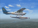
Hydro Quebec operates Dash-8's in those colors but not a 206 so I decided that it was time for one. I see those colors at work every day and I simply love them. Again thanks to Carenado for this great product ,to Gunnar van der Meeren's repaint template and encouragement from H�¯�¿�½ctor P�¯�¿�½rez Gonz�¯�¿�½lez who got me started in repaints. You must own a registered copy of Carenado's Cessna 206 in order to use these files. I hope you enjoy this repaint to fly in northern Quebec Canada.
| Filename: | Hydro_Quebec__Cessna_206_amphibian.zip |
| License: | Freeware |
| Added: | 22nd March 2010, 10:40:11 |
| Downloads: | 178 |
| Author: | Paul Grenier / Carenado |
| Size: | 692.57 KB |
| Category: Flight Simulator X - Scenery | |
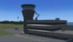
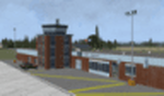
| CYSC Sherbrooke Airport - Quebec, Canada |
|
Images related to this file:
File Description:
This scenery includes all buildings for Sherbrooke Airport (CYSC) developed in GMAX, as well as a patch to remove Aerport of Lenoxville (Airview) since it no longer exists. CYSC now features:
Two-level air terminal with a pilots' lounge;
Paved parking lot with space for approximately 80 vehicles;
Commercial hangar;
Private hangars for aircraft storage;
Aircraft taxiways;
Asphalt runway, 5,900 feet long by 150 feet wide;
Several electronic instruments and visual aids for aerial navigation;
Automated Meteorological observation station.
| Filename: | CYSC_Sherbrooke_Airport__Quebec_Canada.zip |
| License: | Freeware, limited distribution |
| Added: | 23rd December 2012, 16:03:18 |
| Downloads: | 2,786 |
| Author: | Pierre Gallant |
| Size: | 9.94 MB |
| Category: Flight Simulator X - Scenery | |
| Sept-Iles, Quebec (CYZV) Airport |
|
Images related to this file:
File Description:
This scenery is a rendition of Sept-Iles (CYZV) airport using GMAX for FSX SP2/Acceleration.
| Filename: | SeptIles_Quebec_CYZV_Airport.zip |
| License: | Freeware, limited distribution |
| Added: | 24th April 2011, 13:56:01 |
| Downloads: | 4,699 |
| Author: | Pierre Gallant |
| Size: | 11.73 MB |
| Category: Flight Simulator X - Scenery | |
| Baie-Comeau, Quebec (CYBC) Airport |
|
Images related to this file:
File Description:
This scenery is a rendition of Baie-Comeau (CYBC) airport using GMAX for FSX SP2/Acceleration.
| Filename: | BaieComeau_Quebec_CYBC_Airport.zip |
| License: | Freeware, limited distribution |
| Added: | 24th April 2011, 13:55:51 |
| Downloads: | 4,726 |
| Author: | Pierre Gallant |
| Size: | 10.15 MB |
| Category: Flight Simulator 2004 - Scenery | |
| Anticosti Island in Quebec Canada |
|
Images related to this file:
File Description:
Anticosti Island is in the Gulf of St Lawrence, around 25 miles off the Quebec mainland coast. It is some 40 miles wide and 130 miles long on an east west axis. There are few urban areas and only one that can be described as a small town, namely Port Menier at the western end of the southern coast, with a population of under 1,000. There is a ferry service to the harbour. The airport, Port Menier CYPN, is around 3 miles northeast of the town, with an asphalt runway aligned 11-28, 4,875 feet long and 150 feet wide with PAPI at each end. In 2010 (the approximate date of this scenery) a gravel runway was still visible at the eastern end of the field. This was no longer in use by 2010, except perhaps by small planes on skis in the winter. The island, with its small population, small urban area, and no industry other than logging, has as a result a mainly undisturbed wildlife population. This has made deer hunting and fishing the main tourist activities, with one company (called Safari) having an exclusive licence to exploit large areas of mountains and rivers. Planeloads of hunters and fishermen are flown in on chartered Nolinor Aviation planes from the south. There are a further two airfields in the eastern end of the island, and in 2010 Rivere-Aux-Saumons CTH7 had a 5,500 feet gravel runway, linked by road to a lodge area at the mouth of the river. This is the only lodge area that I have been able to locate, but there are others. To the south Riviere Bell CRB5 had at that time a gravel runway that was 3,000 feet long. This has been lengthened since then and both runways were recently (2021) asphalted. If you find an error email me please, and note that my email address has been changed to rogwens at Gmail dot com.
| Filename: | Anticosti_Island_in_Quebec_Canada.zip |
| License: | Freeware, limited distribution |
| Added: | 31st July 2021, 18:23:40 |
| Downloads: | 80 |
| Author: | Roger Wensley |
| Size: | 11.78 MB |
| Category: Flight Simulator 2004 - Scenery | |
| Alma CYTF in Quebec Canada |
|
Images related to this file:
File Description:
This is the second of five sceneries around Lac Saint-Jean in Quebec, Canada. Alma, the town, is 7 miles east of Lac Saint-Jean, on both the northern and southern banks of the Saguenay River. The airfield is at the southern edge of the town, with a single 13-31 runway 5,000 feet long and approach lighting at both ends. There is a visible ILS sytem but this was no longer in operation by 2010, the approximate date setting of this scenery. The largest operation on the field, by far, is Panorama Helicopters (actually Helicopteres Panorama) and this is reflected in the AI and a parked static helicopter. The ai includes helicopters that were originally posted as part of the payware Alaska Fjords series, with the permission of FSAddon. There are also other planes listed that will be required here or for the future posts in this series and are included here. The amphibious Beaver AI plane will only be available if you already have the payware Aerosoft Beaver installed, and I should have made it clear that the float Beaver included in the CTD3 AI was also an Aerosoft plane.
| Filename: | Alma_CYTF_in_Quebec_Canada.zip |
| License: | Freeware, limited distribution |
| Added: | 6th November 2017, 19:30:34 |
| Downloads: | 226 |
| Author: | Roger Wensley |
| Size: | 17.42 MB |
| Category: Flight Simulator 2004 - Scenery | |
| Inukjuak CYPH - Northern Quebec, Canada |
|
Images related to this file:
File Description:
Inukjuak is a fairly large village on the east coast of Hudson Bay, in Quebec, around 115 miles south of Puvirnituq. The usual Hudson Bay Company post was established there in 1920, and with the opening of a school in 1951 the population grew as the nomadic way of life faded away; the population is now around 1350. Some of the population was forcibly relocated to Resolute and Grise Fiord in 1953 as "human flagpoles", a shameful act by the Canadian government that is hard to believe could ever happen. The airfield is a mile inland from the village and the 3,520 feet of gravel runway is aligned 07/25, and these are magnetic bearings as Inukjuak is not in the Northern Domestic Airspace zone. Both JETA-1 and 100LL fuel is available, though there may be only a limited quantity of 100LL, and probably in drums. The visiting AI airline is Air Inuit.
| Filename: | Inukjuak_CYPH__Northern_Quebec_Canada.zip |
| License: | Freeware, limited distribution |
| Added: | 12th December 2011, 14:44:32 |
| Downloads: | 539 |
| Author: | Roger Wensley |
| Size: | 1.81 MB |
| Category: Flight Simulator 2004 - Scenery | |
| Anticosti Island in Quebec Canada |
|
Images related to this file:
File Description:
Anticosti Island is in the Gulf of St Lawrence, around 25 miles off the Quebec mainland coast. It is some 40 miles wide and 130 miles long on an east west axis. There are few urban areas and only one that can be described as a small town, namely Port Menier at the western end of the southern coast, with a population of under 1,000. There is a ferry service to the harbour.
The airport, Port Menier CYPN, is around 3 miles northeast of the town, with an asphalt runway aligned 11-28, 4,875 feet long and 150 feet wide with PAPI at each end. In 2010 (the approximate date of this scenery) a gravel runway was still visible at the eastern end of the field. This was no longer in use by 2010, except perhaps by small planes on skis in the winter.
The island, with its small population, small urban area, and no industry other than logging, has as a result a mainly undisturbed wildlife population. This has made deer hunting and fishing the main tourist activities, with one company (called Safari) having an exclusive licence to exploit large areas of mountains and rivers. Planeloads of hunters and fishermen are flown in on chartered Nolinor Aviation planes, landing at CYPN. There are a further two airfields in the eastern end of the island, and in 2010 Rivere-Aux-Saumons CTH7 had a 5,500 feet gravel runway, linked by road to a lodge area at the mouth of the river. This is the only lodge area that I have been able to locate, but there are others. To the south Riviere Bell CRB5 had at that time a gravel runway that was 3,000 feet long. This has been lengthened since then and both runways were recently (2021) asphalted.
If you find an error email me please, and note that my email address has been changed to rogwens at Gmail dot com. The reason I am posting this now is that I discovered that my original post ended up in MSFS Original Aircraft instead of in FS2004 Scenery. Ooops!
| Filename: | Anticosti_Island_in_Quebec_Canada.zip |
| License: | Freeware, limited distribution |
| Added: | 28th January 2022, 17:39:46 |
| Downloads: | 121 |
| Author: | Roger Wensley |
| Size: | 11.78 MB |
| Category: Flight Simulator 2004 - Scenery | |
| (CSS3) Les Cedres, Quebec, Canada |
|
File Description:
Situated just 20 miles southwest of Montreal international airport (CYUL), it is the home of Laurentide aviation school. Gmax buildings, Landclass of the area, AI trafic and AFCAD file included. With buildings in Vaudreuil: Cite des jeunes and the Future complex. Most of the textures are from photographs. My first contribution.
| Filename: | CSS3_Les_Cedres_Quebec_Canada.zip |
| License: | Freeware, limited distribution |
| Added: | 27th February 2005, 20:41:24 |
| Downloads: | 3,933 |
| Author: | Jacques Bellavance |
| Size: | 590.72 KB |
| Category: Flight Simulator 2004 - Scenery | |
| Kangirsuk CYAS in Quebec Canada |
|
Images related to this file:
File Description:
Kangirsuk is an Inuit village in northern Quebec, on the coast of Ungava Bay. The airport is the only means of access on this coast for the population of around 550, apart from a period in late summer. It is between Quaqtaq and Aupaluk, and around 140 miles north of Kuujjuaq, a major centre in this area for supplies, medical care, education, and anything to do with local government. This version of the airport and village is from around 2010, with the original terminal building that has now been replaced. The runway is just under 3,500 feet of lit gravel aligned 04-22 and the AI includes the daily Air Inuit flight that connects Kangirsuk with Kuujjuaq and other local airfields en route. This is almost certainly the last of the northern Quebec coastal airfields that I will be able to model with the correct buildings; only two missing so not too bad.
| Filename: | Kangirsuk_CYAS_in_Quebec_Canada.zip |
| License: | Freeware, limited distribution |
| Added: | 27th August 2020, 17:41:07 |
| Downloads: | 84 |
| Author: | Roger Wensley |
| Size: | 5.67 MB |
© 2001-2026 AVSIM Online
All Rights Reserved
Privacy Policy |