
Where Flight Simulation Enthusiasts Gather from Around the World!
AVSIM Library - Search Results

| Category: Flight Simulator 2004 - Scenery | |
| USS Langley relocation in the Solomon Islands |

|
File Description:
This file relocates the USS Langley of the MAAM Avenger package in the middle of the Solomon Islands between the Vella LaVella and Kolombangara islands. She becomes CVL 29. It does not interfere with the original CVL 27 or Dogknot's Puget Sound CVL 28.
| Filename: | USS_Langley_relocation_in_the_Solomon_Islands.zip |
| License: | Freeware, limited distribution |
| Added: | 2nd July 2008, 15:31:28 |
| Downloads: | 1,354 |
| Author: | Dominique Klein |
| Size: | 674.35 KB |
| Category: Flight Simulator 2004 - Aircraft Repaints, Textures and Modifications | |
| Lockheed L1011 in the Thai Sky livery |
|
Images related to this file:
File Description:
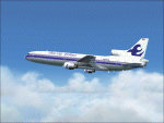
Re-upload. Thai Sky airline is still operating the venerable Lockheed L-1011 to this day. Most of its routes are out of Bangkok to points throughout South East Asia although I occasionally see them leaving Chiang Mai Int. airport in the north of Thailand. The model is by Mike Stone. The wings, pylon, and engine textures are completely new to this model and better represent the look of the real aircraft. All textures contain a mix of 32 bit 888-8 and DXT3 formats, to insure clarity with minimal loss of frame rates plus custom alphas for realistic reflections. I recommend using the REAL Rolls Royce RB211 soundset from Skysong Soundworks and any L1011 panel by Ken Mitchell which are both available on Avsim. Enjoy !!!
| Filename: | Lockheed_L1011_in_the_Thai_Sky_livery.zip |
| License: | Freeware |
| Added: | 3rd June 2010, 03:35:04 |
| Downloads: | 218 |
| Author: | Ron Horn |
| Size: | 1.84 MB |
| Category: Flight Simulator 2004 - Aircraft Repaints, Textures and Modifications | |
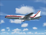
| Lockheed L1011 in the Total Air livery |
|
Images related to this file:
File Description:

Re-upload. Total Air operated the Lockheed L-1011 during the early 80's and I suspect eventually became Air America. Their livery is similar and the aircraft tail numbers were the same. The model is by Mike Stone. The wings, pylon, and engine textures are completely new to this model and better represent the look of the real aircraft. All textures contain a mix of 32 bit 888-8 and DXT3 formats, to insure clarity with minimal loss of frame rates plus custom alphas for realistic reflections. I recommend using the REAL Rolls Royce RB211 soundset from Skysong Soundworks and any L1011 panel by Ken Mitchell which are both available on Avsim. Enjoy !!!
| Filename: | Lockheed_L1011_in_the_Total_Air_livery.zip |
| License: | Freeware |
| Added: | 3rd June 2010, 03:42:43 |
| Downloads: | 124 |
| Author: | Ron Horn |
| Size: | 1.52 MB |
| Category: Flight Simulator 2004 - Scenery | |
| FS2004-Firefighting in the French Alps Version2 |
|
File Description:
My previous addon "Luc-Aix-Fire.zip" was a single forestfire, active at all times, 24/24 h. I decided to bring in some more fun, and give it some changes: 2 different fire locations, with different firing times in the day. More accurate forestfire effect, smoke reacting with the wind, spray effect on scooping, and waterdrop effect completely reworked. Some sailboats and pleasure boats added on the lakes, making landing/take off manoeuvres more...challenging. Readme.txt in English and French.
| Filename: | FS2004Firefighting_in_the__French_Alps_Version2.zip |
| License: | Freeware |
| Added: | 1st May 2011, 20:14:00 |
| Downloads: | 494 |
| Author: | Luc Vermaut |
| Size: | 3.42 MB |
| Category: Flight Simulator 2004 - Aircraft Repaints, Textures and Modifications | |
| Lockheed L1011 in the Air America livery. |
|
Images related to this file:
File Description:
Re-upload. Air America, the secret airline operated by the CIA during the Vietnam War graces the famous Lockheed L-1011 during the late 80's. Whether this airline had any connections to the infamous Air America of the war era I do not know nor have I been able to gather any information on it. The livery looks good on Mike Stone's model. The wings, pylon, and engine textures are completely new to this model and better represent the look of the real aircraft. All textures contain a mix of 32 bit 888-8 and DXT3 formats, to insure clarity without loss of frame rates plus custom alphas for realistic reflections. I recommend using the REAL Rolls Royce RB211 soundset from Skysong Soundworks and any L1011 panel by Ken Mitchell which are both available on Avsim. Enjoy !!!
| Filename: | Lockheed_L1011_in_the_Air_America_livery.zip |
| License: | Freeware |
| Added: | 3rd June 2010, 03:36:20 |
| Downloads: | 193 |
| Author: | Ron Horn |
| Size: | 1.41 MB |
| Category: Flight Simulator 2004 - Scenery | |
| The AWA Building/Tower in Sydney Australia |
|
File Description:
Placed to fit with Version 1.1 of VISTA AUSTRALIS (released 3-29-06). Designed using original photos from the 1930's and discussions with Bruce Kennewell. GMAX model with DXT1 textures and night lighting. REQUIRED (and HIGHLY desirable): VISTA AUSTRALIS Ver. 1.1 available, FREE, at http://vistaoz.org/
| Filename: | The_AWA_BuildingTower_in_Sydney_Australia.zip |
| License: | Freeware |
| Added: | 1st April 2006, 05:31:13 |
| Downloads: | 1,242 |
| Author: | Lou Frost |
| Size: | 499.68 KB |
| Category: Flight Simulator 2004 - Scenery | |
| Paulatuk CYPC in the Northwest Territories, Canada |
|
Images related to this file:
File Description:
Paulatuk is on the coast of northern mainland Canada, 200 miles east of Tuktoyaktuk and 170 miles southwest of Ulukhaktok. It is just to the east of the Parry Peninsula, which has at its northern tip the Cape Parry DEW line Main Station. Paulatuk was established in the 1920's, and the population now numbers around 320. Paulatuk airfield is close to the village but on higher ground, while the village follows the curve of the coast. The 4,000 feet of 100 feet wide gravel runway is aligned 021T/201T where T stands for "true" as opposed to magnetic in the Northern Domestic Airspace. Only JETA-1 is available unless there is 100LL in drums. There are flights by Aklak Air from Inuvik, which is around 250 miles to the west; Aklak Air is actually Kenn Borek under a diferent name. The AI is for a daily passenger flight, and for a cargo flight on Wednesdays. In the summer, float planes use the lake to the south of the village, but I have no information as to docks or any other facilities; probably there aren't any.
| Filename: | Paulatuk_CYPC_in_the_Northwest_Territories_Canada.zip |
| License: | Freeware, limited distribution |
| Added: | 3rd December 2012, 21:58:47 |
| Downloads: | 277 |
| Author: | Roger Wensley |
| Size: | 4.39 MB |
| Category: Flight Simulator 2004 - Scenery | |
| Inuvik CYXT in the Northwest Territories, Canada |
|
Images related to this file:
File Description:
Inuvik is a town of 3,500 or so inhabitants at N68 18 W133 29, which puts it 120 miles inside the Arctic Circle on the east side of the Mackenzie River delta and around 90 miles from where the Mackenzie meets the Beaufort Sea. There is a Canadian Forces base at the eastern end of the field, with shelters for six F18 fighters; the base in one form or another has been there for a while and is the reason for the generous length of asphalt runway.
Inuvik was established in the early 1960's as a replacement regional center for Aklavik which is 40 miles to the west across the delta and which flooded on a regular and inconvenient basis. This probably works without Ultimate Terrain but I haven't tested it. I also haven't tested it in FSX but I was told it works there too.
| Filename: | Inuvik_CYXT_in_the_Northwest_Territories_Canada.zip |
| License: | Freeware, limited distribution |
| Added: | 6th October 2010, 13:22:04 |
| Downloads: | 942 |
| Author: | Roger Wensley |
| Size: | 4.12 MB |
| Category: Flight Simulator 2004 - Scenery | |
| Lutselk'e CYLK in the Northwest Territories, Canada |
|
Images related to this file:
File Description:
Lutselk'e is a village on the southern shore of the Great Slave Lake, at the eastern end and about 120 miles east of Yellowknife. The Hudson Bay trading company established a post there in 1925, and the current school opened in 1960. The population is in the region of 330. There is no road access, but the government runs a freight shipping service during the ice-free period of the Summer. The airfield is a mile or so east of the village, with a runway of around 3,500 feet of gravel aligned 08-26 with PAPI at both ends and lit, with lights atop traffic cones. There are scheduled flights from Yellowknife by Air Tindi, included in the AI, as is a once a week freight flight by Buffalo Airways. You will need to have downloaded and installed my runway and taxiway lighting library from recent posts. A note here about my scenery making. There will not be many more to follow this as I am almost at the end of the photos I either took or found for scenery purposes, plus I expect to move on from FS9 at some point during next year.
| Filename: | Lutselke_CYLK_in_the_Northwest_Territories_Canada.zip |
| License: | Freeware, limited distribution |
| Added: | 9th December 2019, 18:04:52 |
| Downloads: | 104 |
| Author: | Roger Wensley |
| Size: | 3.25 MB |
| Category: Flight Simulator 2004 - Scenery | |
| Whati CEM3 in the Northwest Territories, Canada |
|
Images related to this file:
File Description:
Whati is a village at the southern end of Lac La Martre, a smaller lake (only by Canadian standards, at over 40 miles long) halfway between the Great Slave Lake and the Great Bear Lake and around 100 miles north of Yellowknife. The North West Company established a trading post there in 1793, and this was the centre for local trading in the area for 100 years until a post was opened by the Hudson Bay Company on the Great Slave Lake. The current population is in the region of 520. There is no graded road access and access is by boat or air. The main local economy revolves around hunting and fishing, with efforts being made to increase tourism amid the wilderness and the wildlife. The airfield is just over a mile east of the village, with a runway of around 3,400 feet of gravel aligned 09-27 as of 2010, with PAPI at both ends and lit. There are scheduled flights from Yellowknife by Air Tindi, included in the AI, and some GA. The terminal building is similar to that of Lutselk'e, but with a different colour scheme and with solar panels on the roof. It appears that they repaint the sign on the front of the building with a different wording every time; the one I have used is one of three that have existed in the last few years. The photos I had originally were taken in the winter, with snow. Seeing it in the summer I discovered that my version of the building is not at the right level above the ground by about a foot, or 30cm. I was too lazy to make it again, which was the only way to get it right and still have it throw a shadow on the ground. This scenery modifies the lake shore, corrects levels for land and lake, and adds the village and a connecting road in addition to the airport. A note here about my scenery making. There will not be many more to follow this as I am almost at the end of the photos I either took or found for scenery purposes, plus I expect to move on from FS9 at some point during next year.
| Filename: | Whati_CEM3_in_the_Northwest_Territories_Canada.zip |
| License: | Freeware, limited distribution |
| Added: | 15th December 2019, 19:18:29 |
| Downloads: | 148 |
| Author: | Roger Wensley |
| Size: | 4.25 MB |
© 2001-2026 AVSIM Online
All Rights Reserved
Privacy Policy |