
Where Flight Simulation Enthusiasts Gather from Around the World!
AVSIM Library - Search Results

| Category: Flight Simulator 2004 - Helicopters | |
| Robinson R22 in Red with Gold Trim |

|
File Description:
FS2004. Robinson R22.
Repaint of default Robinson R22 in Red with gold trim.
| Filename: | Robinson_R22_in_Red_with_Gold_Trim.zip |
| License: | Freeware |
| Added: | 21st September 2003, 01:31:42 |
| Downloads: | 533 |
| Author: | David Robinson |
| Size: | 1.62 MB |
| Category: Flight Simulator X - Aircraft Repaints, Textures and Modifications | |
| Harrier ZG506 in GR1 Retro Paint Scheme |
|
Images related to this file:
File Description:
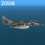
This repaint has been made for the RAZBAM Harrier GR7 / GR9 with the use of their paintkit with a few modifications .
Repaint is of ZG506 in GR1 retro paintscheme in December 2010 .
| Filename: | Harrier_ZG506_in_GR1_Retro_Paint_Scheme.zip |
| License: | Freeware |
| Added: | 22nd January 2014, 03:05:22 |
| Downloads: | 240 |
| Author: | John Glanville / Razbam |
| Size: | 10.47 MB |
| Category: Flight Simulator 2004 - Scenery | |
| Grande Prairie CYQU in Alberta, Canada, Updated |
|
Images related to this file:
File Description:
This is a new version of the original post from March 2014, made in 2018. It was made mainly to provide some missing textures, but has been modified to also add parked trucks and floodlights to the de-icing area (the floodlights are inoperative as they will not be on when there is no de-icing in progress) and also street and car parking lighting, a few more parked planes, and some further objects on the terminal apron area. The runway approach lighting was also corrected; moving the airport so that the ILS on 29 did not coincide with the roads would have been nice, but meant too many complications at this stage. The scenery is complete in itself and can be installed as-is if you do not have the original post. Grande Prairie is at 2,195 feet asl, 65 miles southeast of Dawsons Creek, 90 miles southwest of Peace River and around 60 miles east of the Rockies. The town has a population of around 55,000 and growing. The name comes from the wide expanse of prairies all around the town, and there is also a large forested area to the southwest leading up to the Rockies which supplies raw material for industries in the town. The airport is just to the west of the town. It was originally a military base, built during WW2. The two runways are 07-25 and 11-29 and 6,200 and 6,500 feet respectively, both 200 feet wide; runway headings had changed by 2010 in real life but take this as it was in 2008. When one is the active runway then the other is used as a taxiway. Taxiway A is very wide with in real life a repaired central section marked out for use.
| Filename: | Grande_Prairie_CYQU_in_Alberta_Canada_Updated.zip |
| License: | Freeware, limited distribution |
| Added: | 13th December 2018, 04:12:11 |
| Downloads: | 208 |
| Author: | Roger Wensley |
| Size: | 34.97 MB |
| Category: Flight Simulator 2004 - Scenery | |
| Yorkshire Gliding Club EG96 in Yorkshire, England |
|
Images related to this file:
File Description:
These are the buildings, gliders, tow tug, trailers etc on the airfield of the Yorkshire Gliding Club in Yorkshire England. This is on the top of an escarpment just north of the White Horse; take a look at the screenshot and you will see what this refers to. This is made to fit in with the VFR Photographic Scenery made from an aerial survey of England and Wales in the year 2000. This will be known to those who have it, and probably never been heard of by those who don't.
| Filename: | Yorkshire_Gliding_Club_EG96_in_Yorkshire_England.zip |
| License: | Freeware, limited distribution |
| Added: | 12th July 2013, 17:26:17 |
| Downloads: | 266 |
| Author: | Roger Wensley |
| Size: | 2.81 MB |
| Category: Flight Simulator 2004 - Scenery | |
| Prince George CYXS in British Columbia, Canada |
|
File Description:
Prince George is centrally located in British Columbia, mid way between the border with the USA in the south and the northern border with the Northern Territories, and around 100 miles west of the eastern border with Alberta. The town now has a population of around 74,000 and is regarded as the province's northern capital. It is at the meeting point of the Fraser and Nechako rivers and the crossroads of highways 16 and 97. It started out as Fort George in the early 1800's when a trading post was established by the Northwest Company,serviced by paddle boats on the rivers. The railway arrived in the area in 1914 and growth continued, albeit slowly due to wars and the financial collapse of the 1930's. Timber and timber products were and still are the mainstay of the area, along with a military and governmental presence.
The date for this scenery is around 2010. I have made some new buildings from memory and the available information online. They are not totally accurate reproductions; for instance I know that the terminal building is brick faced and also has parts that are stone (or metal?) faced, but where? So I used brick everywhere. The control tower is also brick faced, but is not exactly the right shape. The airport management team have continued to grow the activity and services provided with the result that flights and passenger numbers continue to increase. The 15-33 runway was lengthened to the south, (in the period 2003 to 2005) from the original FS9 scenery 7,400 feet to my updated 11,450 feet with central lighting and ILS at the northern end. This made it the third longest runway in Canada. At the same time a loading/unloading cargo area was created with professionally run storage and also a large scale refueling storage. If DHL want to refuel their 737 then they can do so without making prior arrangements.
The AI included here is for Air Canada Jazz and an Air Canada 737, Westjet 737 and Dash8, a helicopter company that is based there, Pacific Coastal, Central Mountain Air, and GA. The range of airlines and planes reflects the "northern capital" status of the town.
| Filename: | Prince_George_CYXS_in_British_Columbia_Canada.zip |
| License: | Freeware, limited distribution |
| Added: | 11th November 2022, 23:10:19 |
| Downloads: | 160 |
| Author: | Roger Wensley |
| Size: | 28.04 MB |
| Category: Flight Simulator 2004 - Aircraft Repaints, Textures and Modifications | |
| DF-8F Crusader in Drone Controller colors |
|
Images related to this file:
File Description:
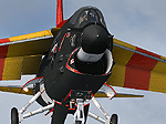
Re-uploaded scheme for the ALPHASIM DF-8F Crusader in Drone Controller colors.( Utility squadron 7 at Nas Miramar, early 60's )
| Filename: | DF8F_Crusader_in_Drone_Controller_colors.zip |
| License: | Freeware |
| Added: | 11th May 2010, 23:15:15 |
| Downloads: | 1,240 |
| Author: | Repaints by pierre lheureux - Plane by Alphasim |
| Size: | 6.45 MB |
| Category: Flight Simulator 2004 - AI Aircraft | |
| Corsair International Fleet in New (2012) colors |
|
Images related to this file:
File Description:

Repaints of Corsair Intl new colors fleet types. A330-200 F-HBIL & F-HCAT, A330-300 F-HSKY and 747-400 F-GTUI. Textures only.This is Part one,others will be followed when painted in real life
You need the Base Models available separately. These are an AI only aircraft
| Filename: | Corsair_International_Fleet_in_New_2012_colors.zip |
| License: | Freeware |
| Added: | 6th December 2012, 04:53:25 |
| Downloads: | 1,727 |
| Author: | Gabe Bierbach, Endeavour AI, TFS & AI Aardvark |
| Size: | 4.21 MB |
| Category: Flight Simulator 2004 - Scenery | |
| Health Bay CAD7 in British Columbia, Canada |
|
Images related to this file:
File Description:
This is the fourth in a series of new and renovated float bases in BC. Health Bay is a small village on the west coast of Gilford Island, just 13 miles northwest of Minstrel Island (the previous post in this series). There is no fuel or oil available. The AI is a further adaptation of the original CF36 AI and involves a Baxter Beaver flying from Port Hardy on a round trip in the area through Port McNeill, Health Bay, Echo Bay, and Sullivan Bay. At Health Bay the AI appears to work for both landing and takeoff, though landing will still depend on wind direction. I have played with circuit height and runway length at Minstrel Island and there are improvements, so there is a Minstrel Island replacement bgl. All of these float bases can be installed together in the same folders, with a saving in duplicate textures. So a series called BC Floats (or whatever you want to call it) or individually installed float bases; your choice. The next in the series will be Echo Bay, shown in an included screenshot.
| Filename: | Health_Bay_CAD7_in_British_Columbia_Canada.zip |
| License: | Freeware, limited distribution |
| Added: | 18th January 2017, 01:15:57 |
| Downloads: | 174 |
| Author: | Roger Wensley |
| Size: | 4.63 MB |
| Category: Flight Simulator 2004 - Miscellaneous Files | |
| All fs9 airports in Google Earth format |
|
File Description:
All fs9 24014 airports in Google Earth format. Very useful to prepare an approach or a flight plan.
| Filename: | All_fs9_airports_in_Google_Earth_format.zip |
| License: | Freeware |
| Added: | 19th June 2007, 00:11:31 |
| Downloads: | 5,868 |
| Author: | Pierre Legault |
| Size: | 1.35 MB |
| Category: Flight Simulator 2004 - Scenery | |
| Northern Canada Mining CYOA & CHB3 in Canada |
|
Images related to this file:
File Description:
These are two airfields in northern Canada, serving two mining operations. The furthest north is Hope Bay CHB3 in Nunavut. It is in a sheltered inlet less than 3 miles from the northern mainland coast and around 65 miles southwest of Cambridge Bay. The owner is Hope Bay Mining Ltd, and their operation mines gold out of a tunnel rather than open cast. The airfield is incorporated into the road that leads north to the sea; traffic is halted by traffic lights when a flight is expected. The runway is 3,000 feet of gravel aligned 01-19 and with PAPI at both ends.
The second airfield serves the Ekati diamond mine and is some 265 miles southwest of Hope Bay, in the Northwest Territories. Ekati was the first Canadian diamond mine and is 195 miles northeast of Yellowknife and less than 20 miles north of a later mine, Diavik (by Sid and Pete). CYOA reflects the relative value of the two mining operations and is far better equipped than Hope Bay. It can be described as an airport while Hope Bay remains an airfield. The runway is 6,400 feet of gravel aligned 36-18 with PAPI and strobe approach lights at both ends. The scale of the mining operation can only be described as huge.
| Filename: | Northern_Canada_Mining_CYOA__CHB3_in_Canada.zip |
| License: | Freeware, limited distribution |
| Added: | 11th August 2018, 22:59:06 |
| Downloads: | 217 |
| Author: | Roger Wensley |
| Size: | 8.24 MB |


© 2001-2026 AVSIM Online
All Rights Reserved
Privacy Policy |