
Where Flight Simulation Enthusiasts Gather from Around the World!
AVSIM Library - Search Results

| Category: Flight Simulator 2004 - Scenery | |
| Unalakleet PAUN modification in Alaska |

|
Images related to this file:
File Description:
This version of Unalakleet PAUN is a modification of the scenery made by Sid and Pete way back in 2011, posted with Sid's knowledge and ok. There is a dearth of photographic information available on PAUN and it was only recently that there was enough so that hangars could be properly made and also properly situated. Which is why I made this now with a new ERA hangar, a new beige hangar rotated 90 degrees, next to it a blue hangar, plus fuel tanks, signage, and updated AI to include ERA planes, a NAC B737 and a NAC DC6B. Unalakleet has a population approaching 700, and lives by the income earned from the harvest from the sea and the river. There is no road within hundreds of miles and the only way to get food or anything else delivered is by ship (but only in the ice-free summer months) or through the airport.
| Filename: | Unalakleet_PAUN_modification_in_Alaska.zip |
| License: | Freeware, limited distribution |
| Added: | 24th July 2019, 18:55:37 |
| Downloads: | 245 |
| Author: | Roger Wensley |
| Size: | 3.94 MB |
| Category: Flight Simulator X - Flight Plans | |
| Dragoon Landings in Southern France |
|
Images related to this file:
File Description:
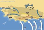
After Overlord the IX Troop Carrier Command send its aircraft to Italy. The southern France landing have been prepared since January 1944 but postponed due to the lack of aircraft. Finally it took place on 15th August 1944 and the Rugby Force could be delivered. 0030, 14th August, Marcigliana Airfield, the first Pathfinders took off. It's your turn to fly towards France. For each Troop Carrier Wing you have the provisional airfield, the .pln file and the flight route log.
| Filename: | Dragoon_Landings_in_Southern_France.zip |
| License: | Freeware |
| Added: | 20th October 2020, 23:17:27 |
| Downloads: | 62 |
| Author: | Bernard DROYERRE |
| Size: | 810.3 KB |
| Category: Flight Simulator 2004 - Scenery | |
| Homer PaHO in Alaska US |
|
Images related to this file:
File Description:
Homer is a mainly GA airfield with rows of open air parking, but it also has scheduled flights, a terminal building, a long (for GA) runway of just under 6,700 feet that is 150 feet wide and aligned 03-21 with VASI on both ends and ILS on 03. So I think we can refer to it as an airport. Plus, at the time of this scenery (around 2010) there were three newly completed hangars on the north apron that I was told were for three companies, Bald Mountain Air service, Maritime Helicopters, and Pathfinder Aviation. I do not know which was for whom, but all three companies are in the helicopter and/or plane charter business. The south apron has a number of hangars and other buildings along it's length, starting at the western end with Smokey Bay Air that has an old control tower on the roof, then the Fire Station, and then Homer Air. I am not aware of who owns what after those first three, except that at the far eastern end there are several garages etc for the airport maintenance equipment. Next to the airport at that end there are a number of boat maintenance companies with boats pulled out of the water; this could not be well replicated due to the airport elevation above the sea level and a misplaced road. The nearby Beluga Lake 5BL float base is also included here, with some AI. The lake height above sea level has been adjusted to cope with too many cliffs intruding into the water; this is an annoying FS9 habit. The Homer scenery is as close to the actual airport as I could make it, while coping with inaccurate coast lines and roads, and grassed areas that could not all be modified for reasons that I will not bore you with. The Spit is a major scenery feature next to the airport, and I have added to this to provide some boats, docks, and nearby buildings etc. Small planes use the adjacent gravel taxi path instead of the runway when back-tracking to take off on runway 21. They only go as far as the path takes them and then u-turn onto the runway and take off. By the way, this airport's AI will function at its best if the prevailing wind makes 03 the runway in use. And I will eventually stop writing 03 and just call it 3, as the US, alone in the world, does not put a zero in front of 01, 02, 03, 04 etc. Just one other thing to note is that all access to the runway is from taxiways A and B; there was (in 2010) no access to the extreme western end of the runway as the taxiway there is marked as out of service pending a needed resurfacing.
If you find an error email me please, and note that my email address has been changed to rogwens at Gmail dot com.
| Filename: | Homer_PaHO_in_Alaska_US.zip |
| License: | Freeware, limited distribution |
| Added: | 28th July 2021, 03:31:04 |
| Downloads: | 125 |
| Author: | Roger Wensley |
| Size: | 11.86 MB |
| Category: Flight Simulator 2004 - Scenery | |
| Graham Field in Anchorage, Alaska |
|
File Description:
This scenery is located in Anchorage Alaska. All default enhanced.
Airport name,
1.Graham field(48AK). 2 Aircraft doing touch and go's around the field. will start at 22:00GMT.
Aircraft involved: Vega5c. call sign 41 bravo charlie. Vega5b. call sign 10 bravo delta.
| Filename: | Graham_Field_in_Anchorage_Alaska.zip |
| License: | Freeware |
| Added: | 24th January 2004, 23:43:02 |
| Downloads: | 2,253 |
| Author: | Frank Betts |
| Size: | 1.28 MB |
| Category: Flight Simulator 2004 - Scenery | |
| FS9 Allakaket 6A8 in Alaska |
|
Images related to this file:
File Description:
Allakaket is on the Koyukuk River in Alaska, 40 miles southwest of Bettles. The population is just over 100, with a school that was opened in 1957 for both Allakaket and the nearby Alatna on the other side of the river. There was a very serious flood in 1964 with almost all of the village being underwater, and this resulted in the establishment of an additional housing area further inland and explains the thinly scattered housing in the original village site. The airfield was established in 1978 and has a gravel runway aligned 5-23 (or 05-23 if you are not American) that is just over 4,500 feet in length. Both the runway and the taxiway are marked with lit cones. The village airfield is served by Wright Air and Warbelows Air, both of them being based in Fairbanks and included in the revised AI for PANN that is included here. There are occasional other larger freight flights as required as there is no road access to the village and the river is too shallow to allow large freight barges; hence the runway length.
A note here about my scenery making. There will not be many more to follow this as I am almost at the end of the photos I either took or found for scenery purposes, plus I expect to move on from FS9 at some point during next year.
| Filename: | FS9_Allakaket_6A8_in_Alaska.zip |
| License: | Freeware, limited distribution |
| Added: | 23rd November 2019, 20:29:35 |
| Downloads: | 122 |
| Author: | Roger Wensley |
| Size: | 3.78 MB |
| Category: Flight Simulator 2004 - Aircraft Repaints, Textures and Modifications | |
| Default Cessna 182 in Red |
|
File Description:
This is an edit of the default green & white paint. I edited the textures in Photoshop to change the green into red. The red color is the same shade used by Bush Flying Unlimited, but there are no BFU logos on it.
| Filename: | Default_Cessna_182_in_Red.zip |
| License: | Freeware |
| Added: | 29th December 2004, 04:56:28 |
| Downloads: | 1,639 |
| Author: | Jim Chaney |
| Size: | 1.3 MB |
| Category: Flight Simulator 2004 - Aircraft Repaints, Textures and Modifications | |
| dc2 uiver in boac livery |
|
File Description:
My interpretation of the dc2 in Imperial/BOAC livery, purely fictional
| Filename: | dc2_uiver_in_boac_livery.zip |
| License: | Freeware |
| Added: | 7th June 2021, 17:34:46 |
| Downloads: | 31 |
| Author: | Michael Evans |
| Size: | 8.74 MB |
| Category: Flight Simulator 2004 - Scenery | |
| Whitefish 58S in Montana US |
|
Images related to this file:
File Description:
I have made this because I downloaded and tried the Glacier Park scenery by Blue Sky Scenery and then discovered that the runway for Whitefish was wrongly aligned and headed off across the adjacent railroad tracks. This would be inconvenient if you had to wait for a train to pass before landing so I fixed that and added a couple of buildings. That's it, nothing more complicated than that. If I find some more airfields in this area with similar problems then I'll do more of the same. Whitefish is 3 or so miles north of Glacier Park International at 3,066 feet ASL and around 35 miles south of the Canadian border. There are no large towns close by; the nearest would be Missoula, which is 90 miles further south.
| Filename: | Whitefish_58S_in_Montana_US.zip |
| License: | Freeware, limited distribution |
| Added: | 23rd May 2010, 02:05:52 |
| Downloads: | 194 |
| Author: | Roger Wensley |
| Size: | 826.52 KB |
| Category: Flight Simulator 2004 - Scenery | |
| Wakefield riverfront in Quebec Canada |
|
Images related to this file:
File Description:
The village of Wakefield is 18 miles northwest of Ottawa on the west shore of the Gatineau River, and I seem to have been flying north up that river from Rock cliffe for years, past the village in a bend of the river just a few miles north of Cascades float base. It is where the tourist steam train goes through, and by "through" I mean that literally as the tracks are at the side of the main street, and one of the things it goes past is the Black Sheep Inn which hosts Canadian musical groups and individuals at the weekends. Though the radio in Ottawa uses the name in English it is actually and visibly called "Mouton Noir" on the sign. There is no airfield, and no float base. There aren't even all the buildings that are on the riverfront as it stretches further south and north. There is a public dock where you can tie up. Apart from the fact that the idea caught my fancy one afternoon outside the Mouton Noir I really can't think why I made this.
| Filename: | Wakefield_riverfront_in_Quebec_Canada.zip |
| License: | Freeware, limited distribution |
| Added: | 1st May 2010, 00:39:24 |
| Downloads: | 406 |
| Author: | Roger Wensley |
| Size: | 11.23 MB |
| Category: Flight Simulator 2004 - Scenery | |
| Arviat CYEK in Nunavut, Canada |
|
Images related to this file:
File Description:
Arviat is a small town on the west coast of Hudson Bay in Nunavut, around 90 miles south of Whale Cove, 130 miles south of Rankin Inlet, and 160 miles north of Churchill. The airfield is just south of the town, and the 4,000 feet of gravel runway is aligned 149T/329T; these are true bearings and not magnetic as Arviat is just inside the Northern Domestic Airspace zone. There is 100LL fuel available in drums, with 2 hours prior notice. The visiting AI airline is Calm Air, plus a cargo delivery by Buffalo Air. As a town of 2,200 people is too large to model I have used a landclass with autogeneration. The result includes some trees, which is not realistic, but there was no way out. There is a special note in the instructions regarding Flight Ontario replacement textures and "glowing" gravel aprons.
| Filename: | Arviat_CYEK_in_Nunavut_Canada.zip |
| License: | Freeware, limited distribution |
| Added: | 6th January 2012, 16:13:45 |
| Downloads: | 506 |
| Author: | Roger Wensley |
| Size: | 2.19 MB |
© 2001-2026 AVSIM Online
All Rights Reserved
Privacy Policy |