
Where Flight Simulation Enthusiasts Gather from Around the World!
AVSIM Library - Search Results

| Category: Flight Simulator 2004 - AFCAD Files | |
| CYMX - Montreal Mirabel |

|
File Description:
This is the AFCAD file for the "forgotten" airport. Mirabel was created to handel international traffic in the 70's, and Dorval was going to be domestic. Unfortunatly Dorval got a international certificate and Mirabel wasnt to popular and is now a cargo airport and not a passenger one. Mirabel also has the Canadair finishing plant where some CRJ's and Dash-8's are born.
Includes detailed de-icing area, ILS on all runways except 24 (because in real life there isnt any) both CAT II and CAT I. All gates and three mini-terminals. Plus much more that meets the eye.
| Filename: | CYMX__Montreal_Mirabel.zip |
| License: | Freeware |
| Added: | 9th July 2005, 17:19:19 |
| Downloads: | 2,580 |
| Author: | Kevin Gomes - Project Delta Niner |
| Size: | 8.01 KB |
| Category: Flight Simulator 2004 - AI Flight Plans | |
| Northern Air Cargo Summer 2010 |
|
Images related to this file:
File Description:

Northern Air Cargo, based at the Anchorage Ted Stevens International airport operates a small fleet of Boeing 737-200Fs. They took delivery of their fourth 737 on Friday, July 23. Northern Air Cargo serves several locales throughout the state of Alaska. Interestingly, one of their 737s flew down to Laredo, Texas, to support auto parts imports from Mexico to the US. Flights were taken from FlightAware for the week of July 18-24 with 99.5% of the actual flights included. I had to include a positioning flight from Laredo back to Anchorage late Sunday in order to make the flightplans work.
| Filename: | Northern_Air_Cargo_Summer_2010.zip |
| License: | Freeware |
| Added: | 1st August 2010, 23:33:51 |
| Downloads: | 1,002 |
| Author: | Steve Lewis |
| Size: | 178.48 KB |
| Category: Flight Simulator 2004 - AFCAD Files | |
| LTBA 2008 v1.21 with advanced x-wind settings |
|
Images related to this file:
File Description:
ADE9X rework of freeware LTBA 2008 v1.21 by Gokhan Bayrakdar (ltba_2008_v1.21.zip). Features: Runway 06/24 renumbered 05/23 (WEF 30JUL10) and stretched, revised approach code including new approaches for rwy 05/23, rapid exits E2, E3 & E6 added to runway 05/23, taxiway network updated with current designators & taxi signs, parking sizes & codes revised, 2nd tower frequency corrected (118.57MHz), tyre marks on TDZ for runways 05/23/18L/36R (runway 18R/L closed for landing), and an experimental set of crosswind runway activations depending on wind conditions. Read carefully the readme for details & installation instructions.
| Filename: | LTBA_2008_v121_with_advanced_xwind_settings.zip |
| License: | Freeware |
| Added: | 28th September 2010, 17:46:40 |
| Downloads: | 1,950 |
| Author: | Yohann Baptiste |
| Size: | 409.86 KB |
| Category: Flight Simulator 2004 - Aircraft Repaints, Textures and Modifications | |
| TWA Lockheed L-749 Constellation |
|
Images related to this file:
File Description:
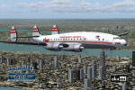
TWA Lockheed L-749 N6003C, c/n 2635, short nose version in colors of about 1954. Delivered to "Transcontinental & Western Air" on 24 April 1950 carrying the name "Star of Texas" and fleet number "803". When in 1950 the airline changed its name to Trans World Airlines "803" renamed "Star of America". In December 1966 withdrawn from use and stored at Kansas City. On 17 August 1968 bought by Aero-Tech and transferred to Tucson,
Arizona, stored and finally broken up in October 1973.
Textures only. The FS2004/FSX Lockheed L-749 Constellation Base Kit (lockheed749.zip) must be installed.
| Filename: | TWA_Lockheed_L749_Constellation.zip |
| License: | Freeware, limited distribution |
| Added: | 11th January 2010, 20:21:00 |
| Downloads: | 1,647 |
| Author: | Original by Manfred Jahn & Co (Team 749); Repainted by Hans Hermann, Virtual Birds Factory |
| Size: | 4.01 MB |
| Category: Flight Simulator 2004 - Helicopters | |
| KOIN TV "Chopper Six" |
|
File Description:
This repaint depicts the paint scheme currently being used by Portland, Oregon TV station KOIN-TV Channel Six. This paint scheme has been in use for over five years. Hillsboro Aviation leases the helicopter to KOIN, and also provides the helicopter for KATU Channel 2, Portland, as well as a helicopter for aerial tours of the Mount St. Helens blast area. In 1998, KOIN Television and Portland-area Circuit City stores teamed up to market a 1:24 scale toy replica of Chopper Six, complete with working navigation beacons and spinning rotor blades. Requires Owen Hewitt's Bell JetRanger package.
| Filename: | KOIN_TV_Chopper_Six.zip |
| License: | Freeware |
| Added: | 16th August 2005, 03:35:11 |
| Downloads: | 223 |
| Author: | Steven Rosenow |
| Size: | 5.19 MB |
| Category: Flight Simulator X - Aircraft Repaints, Textures and Modifications | |
| RAF "Desert Air Force" North American AT-6 (VH-TXN) |
|
Images related to this file:
File Description:
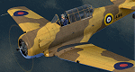
This is a repaint for the payware A2A Simulations AT-6 Texan. This repaint depicts the restored Noorduyn-built Harvard Mk.IIb c/n 14A-1106, owned/operated by John Rayner, based in Australia, and registered as VH-TXN. This aircraft originally served with the RCAF during WWII as FS966, training Commonwealth pilots in the Empire Air Training Scheme in Canada, and from 1946 until 1969 served in the Swedish AF as Sk 16A #16077. Traded from the Swedish AF Museum in 1980 to an Australian collector, the aircraft was later purchased by John Rayner in 1994 and fully restored. The aircraft is painted in the markings of one of the three Harvards supplied to RAF 239 Wing (comprising of RAAF (Australian) 3 & 450 Squadrons and RAF (British) 112 & 250 Squadrons), based in North Africa in 1942, for "Wing Training" - general duties of which included providing check-out flights for new pilots and providing ferrying capability for pilots to pick up replacement aircraft.
| Filename: | RAF_Desert_Air_Force_North_American_AT6_VHTXN.zip |
| License: | Freeware |
| Added: | 21st May 2016, 20:36:08 |
| Downloads: | 341 |
| Author: | John Terrell |
| Size: | 40 MB |
| Category: Prepar3D V1-4 - Scenery | |
| Malta Republic of Malta Europa N35.53.00 E14.30.00 |
|
File Description:
Malta N35.53.00 E14.30.00 officially the Republic of Malta and an archipelago located in the Mediterranean, in the
Malta Channel, 80 km from Sicily, 284 km from Tunisia and 333 km from Libya, including in the Italian geographical
region. With an extension of 315.6 km² it is one of the smallest and most densely populated states in the world. Its
capital is Valletta. The main island is characterized by a large number of towns that, together with the capital, form
a conurbation of 368 250 inhabitants. It was a Greek colony later a Roman and Arab colony, and English and only on 21
September 1964 it gained independence from Great Britain. The city of Valletta with its port, the city of Mdina
including the northern part of the Maltese archipelago with the island of Gozo and the Malta airport with its
infrastructures, was particularly taken care of. Within the downloaded package you will find readme files for
scenery installation. Good fly VFR. Pasquale Marrulli.
| Filename: | Malta___Republic_of_Malta_Europa_N355300_E143000.zip |
| License: | Freeware |
| Added: | 14th May 2018, 19:52:40 |
| Downloads: | 321 |
| Author: | Pasquale Marrulli |
| Size: | 3.7 MB |
| Category: Flight Simulator 2004 - Scenery | |
| Ontario Small Fields in Canada: #04 Stoney Point (Le Cunff) CRML V1 |
|
Images related to this file:
File Description:
This is the fourth in a series of small airfields in southern Ontario, Canada. It is Stoney Point (Le Cunff) CRML, a field near a small town (Stoney Point) close to Lake St Clair. The airfield has a grass runway of 2,250 feet, aligned 18/36; with trees around the house gardens between road and runway the south threshold is displaced by 250 feet. The markers approximately show the touchdown point north of the runway end. Le Cunff is the family name of the owners, included to differentiate between this and another Stoney Point field, CRJ2. I found the default FS9 airfield at the correct elevation of 625 feet, but sitting on a plateau, despite my Genesis Mesh. This looked so unreal that I have revised this to an incorrect lower elevation of 580. So if you find the airfield sitting in a hole in your installation you now know the reason. Let me know, with a screenshot please.
| Filename: | Ontario_Small_Fields_in_Canada_04_Stoney_Point_Le_.zip |
| License: | Freeware, limited distribution |
| Added: | 29th July 2015, 16:08:32 |
| Downloads: | 146 |
| Author: | Roger Wensley |
| Size: | 1.6 MB |
| Category: Flight Simulator 2004 - Scenery | |
| Yellowknife CYZF, 2010 |
|
Images related to this file:
File Description:
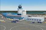
Founded as a gold town in 1936, Yellowknife is now the capital city of the Canadian Northwest Territories, and its airport, CYZF, is the busiest airport in northern Canada. Located only 250 miles south of the Arctic Circle, it is also subject to some of the harshest and most dangerous climate conditions in the world.
This version features:
*All ramps and taxiways completely redone to be more accurate
*All default buildings replaced
*Realistic Gmax models of the main terminal and tower, the First Air, CAF Squadron 440, and Buffalo Airways hangers
*Static aircraft for the First Air, CAF Squadron 440, Air Tindi and Buffalo Airways ramps
*Visual models of the arrestor cables on the main runway
*Fences, ramp lights, cargo, ground vehicles and all the other details that bring an airport to life
*Modular construction. The main buildings, ramp objects and static aircraft are in separate files and can be selectively deactivated to improve frame rates.
| Filename: | Yellowknife_CYZF_2010.zip |
| License: | Freeware |
| Added: | 16th January 2010, 10:31:02 |
| Downloads: | 6,892 |
| Author: | Sidney Schwartz, Peter Ham |
| Size: | 15.42 MB |
| Category: Flight Simulator X - Scenery | |
| Barbados island photo scenery |
|
File Description:
Barbados is my home island so I've decided to make a photo scenery for it. please understand that am not a professional at scenery but if anyone is willing to help me improve it, am open for it.
Barbados is a sovereign island country in the Lesser Antilles, in the Americas. It is 34 kilometres (21 miles) in length and up to 23 km (14 mi) in width,
covering an area of 432 km2 (167 sq mi). It is situated in the western area of the North Atlantic and 100 km (62 mi) east of the Windward Islands and the Caribbean Sea;[6] therein,
it is about 168 km (104 mi) east of the islands of Saint Vincent and the Grenadines and 400 km (250 mi) north-east of Trinidad and Tobago. Barbados is outside of the principal Atlantic hurricane belt.
Its capital is Bridgetown. Barbados is 1,600 mi (2,600 km) Southeast of Miami.
| Filename: | Barbados_island_photo_scenery.zip |
| License: | Freeware |
| Added: | 5th October 2016, 22:31:01 |
| Downloads: | 630 |
| Author: | Shakur Jones |
| Size: | 55.73 MB |
© 2001-2026 AVSIM Online
All Rights Reserved
Privacy Policy |