
Where Flight Simulation Enthusiasts Gather from Around the World!
AVSIM Library - Search Results

| Category: Flight Simulator 2004 - Original Aircraft | |
| Douglas DC-4 and C-54, V3.01 |

|
Images related to this file:
File Description:
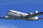
FS2004 Douglas DC-4 and C-54 V3.01. This base package includes 24 colour schemes covering the period 1942-2006, including Pan American, USAAF, SAS, Loftleidir, Buffalo Airways and many others. Version 3.0 model for FS2004, with improved flight dynamics, more accurate model and more details in the virtual cockpit. Model by Jens B. Kristensen. For FS2004 only, FSX users should download DC4_V30X.zip instead. First release had a texture error, this is corrected here.
| Filename: | Douglas_DC4_and_C54_V301.zip |
| License: | Freeware |
| Added: | 19th December 2010, 01:09:42 |
| Downloads: | 4,344 |
| Author: | Jens B. Kristensen |
| Size: | 58.57 MB |
| Category: Flight Simulator X - AFCAD Files | |
| CYQB - Quebec Jean-Lesage Intl. - Canada v3.0 |
|
Images related to this file:
File Description:
This AFCAD file add a new taxiway that connect Taxiway DELTA to Taxiway GOLF.This new infrastructure, approximately 900m in lenght is parallel to the main runway (06-24) improve access to Apron 1 and the runways, minimizing the need to use Runway 12-30 as a taxiway. It will also be used by aircraft leaving the de-icing centre that will be build in a near futur.
It also include the extension of RAMP #3
| Filename: | CYQB__Quebec_JeanLesage_Intl__Canada_v30.zip |
| License: | Freeware |
| Added: | 25th March 2013, 05:28:46 |
| Downloads: | 1,222 |
| Author: | Gilles Boily |
| Size: | 142.3 KB |
| Category: Flight Simulator 2004 - AI Flight Plans | |
| Hard Landings 2 |
|
File Description:
Hard Landings 2 -The hop list from hell .Nepal high in the mountains are some of the hardest landings found in FS9 ,VNBJ-VNRT-VNLK-VNBJ.This scenery completes the hop list with the original hard landings also available on the AVSIM server.
West Coast ATC will be running this as a hop list on the 24HR military server,
and will offer a personalized repaint of their aircraft to the first 4 pilots who manage to survive this hop list and as an added bonus will include 250$ in pilot pay if the winners are members of WestCoastATC.com you can get more info at http://www.westcoastatc.com/events/hard%20landings.shtml and further information is contained in the notes included with this zip
From the VJPL at WestCoastATC.com
| Filename: | Hard_Landings_2.zip |
| License: | Freeware |
| Added: | 21st April 2005, 17:30:42 |
| Downloads: | 722 |
| Author: | Chuck Jodry |
| Size: | 262.11 KB |
| Category: Flight Simulator X - Missions | |
| USA Point of Interest Postcards |
|
File Description:
256 Postcards can be earned for flying to nearly 250 different airports from around the USA and it's territories! Been there and seen that? Now you can have more proof than just whats in your logbook. Install the .rwd file in your rewards folder, and at the next FSX startup your logbook will be scrubbed against the reward file and the appropriate postcards given automatically. Then it's up to you to explore the USA and find the rest of the ones you don't have! Most of the postcards are about aviation and space history; others are national monuments, and still more are popular tourist attractions or the extreme points of the USA. Fully functional and freeware. Fire up your favorite aircraft and go exploring!
| Filename: | USA_Point_of_Interest_Postcards.zip |
| License: | Freeware |
| Added: | 10th May 2008, 23:16:19 |
| Downloads: | 2,524 |
| Author: | Brian Boyce |
| Size: | 2.91 MB |
| Category: Flight Simulator X - AFCAD Files | |
| Dix Field Airport (0NJ6), NJ |
|
File Description:
This another airport I've excised from the default scenery by simply removing the turf runway that was visible over some marshy land. Dix Field is a private strip located 01 miles N of Linwood, New Jersey on 250 acres of land. No facilities or anything, so it's not a big loss.
Scenery constructed with use of satellite images/streetview, the author has not been there in person.
This scenery is meant to be used in conjunction with MegaScenery Earth New Jersey/Delaware 003. It is not required, but apron use is minimized to allow satellite scenery to show through as much as possible, and objects are placed based on the MSE textures - lack of it may make scenery look out of place.
| Filename: | Dix_Field_Airport_0NJ6_NJ.zip |
| License: | Freeware |
| Added: | 21st October 2010, 23:24:08 |
| Downloads: | 180 |
| Author: | Drew Sikora |
| Size: | 125.73 KB |
| Category: Flight Simulator 2004 - Scenery | |
| Minden-Tahoe Airport (KMEV) |
|
File Description:
The Minden-Tahoe Airport(KMEV) is a 990-acre general aviation non-towered airport. Built in 1942 as a military training base, Douglas County acquired the Airport and has operated it as a municipal airport governed by Douglas County Board of County Commissioners. The Airport serves a broad base of aviation uses from corporate to recreational flying. It is home to approximately 250 aircraft with 80,000 annual operation. It is also home to the Minden Tanker Base and the Sierra Front Dispatch Agency with primary mission of dispatching tankers to fires in the Sierra Nevada region. Scenery created with FSDS3, Rwy12, EZ Scenery, AFCAD2 and Traffic Tools2.x. Your choice of Towered or non-towered AFCAD file. See readme for details.
| Filename: | MindenTahoe_Airport_KMEV.zip |
| License: | Freeware |
| Added: | 2nd February 2006, 03:15:10 |
| Downloads: | 1,016 |
| Author: | John B. Loney, Jr. |
| Size: | 619.94 KB |
| Category: Flight Simulator X - Scenery | |
| USA East 10 metre mesh, Batch 4, Part 3 of 9 |
|
File Description:
USA EAST USGS 10 metre mesh terrain - FSX only, includes: IA, MN, WI, IL, IN, MI, OH, PA, NY, VT, NH, ME, MA, CT, RI. Part 3 of 9!
This constitutes 10 metre terrain mesh for a section of the USA, The whole USA East mesh files will abutt the US West Coast 10m mesh already available elsewhere, that was made by: Raimondo Taburet. Make sure you have your scenery terrain settings at about 5 metres in the FSX display dialogue for the mesh to show properly!
| Filename: | USA_East_10_metre_mesh_Batch_4_Part_3_of_9.zip |
| License: | Freeware |
| Added: | 11th May 2009, 10:11:50 |
| Downloads: | 1,062 |
| Author: | Wayne Evans |
| Size: | 29.25 MB |
| Category: Flight Simulator 2002 - Flight Plans | |
| Val-U-Prop VA Bloomington, IN to Pittsburgh |
|
File Description:
This a GPS-flown leisure excursion from the Great Hoosier Nation, over the Buckeye State and on to Pittsburgh PA. Enjoy the hills of Southern Indiana (you will fly right by Lake Monroe - largest lake in the state, just beyond Bloomington) before entering the flatlands of Ohio. Pittsburgh International is in the foothills of the Alleghenies and is surrounded by hills, so be careful. ACS-GPS and other fs98/2000 GPS users may also take part in the flight by selecting Pittsburgh International as their destination. For any airplane. Distance is 304 NM.
| Filename: | ValUProp_VA_Bloomington_IN_to_Pittsburgh.zip |
| License: | Freeware |
| Added: | 8th March 2003, 00:58:57 |
| Downloads: | 256 |
| Author: | James Underwood |
| Size: | 2.46 KB |
| Category: Flight Simulator 2004 - AI Flight Plans | |
| Southeast Airlines Flight Plan |
|
File Description:
Southeast Airlines (Sun Jet International) flight plans for the first week of January 2004 taken from http://www.flyseal.com/schedule/ and generated with Schedule Builder 0.99b Beta. Call Sign: SUN KING ICAO: SNK
Southeast Airlines flies from Columbus Rickenbacker International Airport as well as Las Vegas, NV; Orlando Sanford; Allentown,PA; Newburgh, NY; Newark, NJ; Gulfport, MS; St. Petersburg, FL; Gary, IN; and Ft. Lauderdale, FL. They fly 9 aircraft including 6 DC9-31s, 1 MD82, and 2 MD88s. DC9-31 textures are available for the Aardvark DC9 here at AVSIM.com.
| Filename: | Southeast_Airlines_Flight_Plan.zip |
| License: | Freeware |
| Added: | 31st December 2003, 04:36:37 |
| Downloads: | 1,408 |
| Author: | Steve Lewis |
| Size: | 1.64 KB |
| Category: Flight Simulator X - Scenery | |
| USA East 10 metre mesh, Batch 4, Part 9 of 9 |
|
File Description:
USA EAST USGS 10 metre mesh terrain - FSX only, includes: IA, MN, WI, IL, IN, MI, OH, PA, NY, VT, NH, ME, MA, CT, RI. Part 9 of 9!
This constitutes 10 metre terrain mesh for a section of the USA, The whole USA East mesh files will abutt the US West Coast 10m mesh already available elsewhere, that was made by: Raimondo Taburet. Make sure you have your scenery terrain settings at about 5 metres in the FSX display dialogue for the mesh to show properly!
| Filename: | USA_East_10_metre_mesh_Batch_4_Part_9_of_9.zip |
| License: | Freeware |
| Added: | 11th May 2009, 10:18:22 |
| Downloads: | 1,020 |
| Author: | Wayne Evans |
| Size: | 28.84 MB |
© 2001-2026 AVSIM Online
All Rights Reserved
Privacy Policy |