
Where Flight Simulation Enthusiasts Gather from Around the World!
AVSIM Library - Search Results

| Category: Flight Simulator 2004 - Aircraft Repaints, Textures and Modifications | |
| Virgin Atlantic "Dream Girl" Boeing 787-9 Dreamliner (G-VAHH) |

|
Images related to this file:
File Description:

Virgin Atlantic is a British airline with its head office in Crawley, West Sussex, England. The airline was established in 1984 as British Atlantic Airways, and was originally planned by its co-founders Randolph Fields and Alan Hellary to fly between London and the Falkland Islands. Soon after changing the name to Virgin Atlantic Airways, Fields sold his shares in the company after disagreements with Richard Branson over the management of the company. The maiden flight from Gatwick to Newark Liberty International Airport took place on 22 June 1984. The airline along with Virgin Holidays is controlled by a holding company Virgin Atlantic Limited which is owned 51% by the Virgin Group and 49% by Delta Air Lines.
Virgin Atlantic livery painted on Tenkuu Developers Studio (TDS) Boeing 787-9 Rolls Royce Trent 1000 model. The textures are saved in 32bit format for quality graphics. Textures are also characterized by HD (High Definition). Its features are idle-reverser animation, animated pack vents and pressurisation outflow valve, detailed textures, accurate paint, dynamic shine & effects, dynamic flexing wings that respond to turbulence, fully independent suspension, trim animation, gear steering, accurate flight dynamics, spoiler animation, reflective cockpit windows, improved wingflex code with input from several new parameters including ground spoilers, fuel load, and angle of attack, transparent navigation light lenses and many more. REPAINT TEXTURES ARE ALSO COMPATIBLE WITH THE FSX MODEL (needed).
Visit our Facebook page "Sky Level Textures" for news, updates and previews on my future repaint projects. Thanks for downloading & Happy flying. HD GAMING EXPERIENCE inside. https://www.facebook.com/SkyLevelTextures
| Filename: | Virgin_Atlantic_Dream_Girl_Boeing_7879_Dreamliner_.zip |
| License: | Freeware |
| Added: | 29th April 2015, 04:38:35 |
| Downloads: | 2,376 |
| Author: | Giacomo Tomasini | Sky Level Textures | Tenkuu Developers Studio (TDS) |
| Size: | 24.09 MB |
| Category: Flight Simulator 2004 - Aircraft Repaints, Textures and Modifications | |
| World Fish & Agriculture Inc. "Winkys Fish" Lockheed R7V-1 / C-121J |
|
Images related to this file:
File Description:
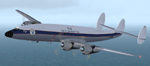
Textures for Lockheed R7V-1/C-121J by Team 1049 - Roland Berger, Volker Boehme, Manfred Jahn, Luis Pallas, Bill Tyne and Stefan Werner. Repainted by Manfred Meyer.
A working installation of the G and H Super Constellation packs (L1049H.ZIP, L1049GZIP and r7v-1.ZIP)is required, use the 1049vc_rf model for this textures!
This aircraft was built 1953 as a R7V-1 BuNo 131643 for US Navy (c/n 4144) and 1960 redesignated as C-121J. Serving whis the Point Mugu Missile Range it was known as the "Ole Blue from Point Mugu". 1974 withdrawn from use and stored at Davis Monthan, she was sold in May 1981 to William "Winky" Crawfords Northern Peninsula Fisheries Corp. and reg. N4247K for hauling salmon in Alaska. After modification work to civil freighter in 1987 the Connie went to World Fish & Agriculture Inc. Cold Bay Alaska, another Crawford Company. Now it was the plan to hauling thunafish from Palau Island to Nagoya in Japan. It was intend to carry 38 000 lbs of fish per trip but only 33 000 lbs were practial. But the contract could not be fullfiled because no high grade AVGAS was available at Nagoya. The aircraft has to carry return fuel in drums, which reduced the payload further to only 15 000 lbs.
Only a few roundtrips were flown in 1988 and then the Connie was impounted and stored at Manila apt. due to lawsuit actions with the contractors. She remains abandonded in open storage at Manila until 2014 as the Quantas Museum from Australia bought her in auction for spares.
| Filename: | World_Fish__Agriculture_Inc_Winkys_Fish_Lockheed_R.zip |
| License: | Freeware |
| Added: | 17th November 2014, 22:44:15 |
| Downloads: | 156 |
| Author: | Manfred Meyer |
| Size: | 5.62 MB |
| Category: Flight Simulator X - Scenery | |
| KSLC - Salt Lake City Intl Airport 2020, Utah, USA |
|
Images related to this file:
File Description:
I have been asked many times could i do an update for SLC, knowing there were going to be major changes there I held off until now when someone sent me a plan for the new terminal layout and its taxiways, so here is my interpretation of what it may look like in 2020.
This is a version of Salt Lake City Intl Airport with two optional files and made only for FSX, do not use in P3D: There is one version with the Crosswind runway 14/32 operating where all 4 runways will be used for takeoff/landing and one version as the default airport runway operation, The new south terminal A and north concourse B have been designed similar to the plan i have, i also had to take a guess at which airlines will park where so may not be accurate on opening day, as a Delta hub they are only assigned to terminal A, most other airlines are assigned to the north concourse B, transient parking is retained in the same place, the north cargo ramp and buildings updated, runway 17/35 is now parallel with 16L/34R which is also part of the upgrade plan, and the approaches for it aligned with the new position, all other approaches and frequencies updated to the latest charts where needed, extra fuel trucks, Helipads/start locations now in their correct positions, De-icing pads added, support vehicle roads rebuilt and many other scenery improvements and objects added, airport views are from the roof of the control tower (when in tower view) please view the readme before installation,
| Filename: | KSLC__Salt_Lake_City_Intl_Airport_2020_Utah_USA.zip |
| License: | Freeware, limited distribution |
| Added: | 6th March 2018, 04:23:35 |
| Downloads: | 44,425 |
| Author: | Ray Smith |
| Size: | 4.91 MB |
| Category: Flight Simulator 2004 - Scenery | |
| Fort Smith CYSM in Northwest Territories, Canada Revised |
|
Images related to this file:
File Description:
This is an updated version to remove an incomplete static Beaver reported by Graeme (thanks Cobber) and to include other modifications that I made for my own version since posting the original; different taxiway lights, revised aprons, and in particular the revised AI that I mentioned in the original 2011 post. This is complete and can be installed as-is, or used to modify an existing post by changing the original folder contents. Fort Smith is just north of the border between Alberta and Northwestern Territories, midway between Lake Athabasca to the southeast and Great Slave Lake to the north west. You might stop there when flying between Yellowknife or Hay River to La Ronge or Saskatoon. It looks as if it is ex-military and these are the remains of what were once 10,000 feet of asphalt runways. The main runway is now 11/29 and 6,000 feet long, and the secondary one is 1,800 feet of mostly gravel. There is an airline based at the field, Northwestern Air, and fuel is available at a self service point. The town of Fort Smith is two miles east of the airfield, on the bank of the Slave River and where there are some rapids that require a portage to get around them. Before aviation came along the river was a major route to the north and all those furry animals, which was why the Hudson's Bay Company established an outpost there in 1872. Today it has a population of 2,400 and the main activities are government administration of much of the Northwest Territories, education, and tourism.
| Filename: | Fort_Smith_CYSM_in_Northwest_Territories_Canada_Re.zip |
| License: | Freeware, limited distribution |
| Added: | 23rd January 2019, 19:14:44 |
| Downloads: | 143 |
| Author: | Roger Wensley |
| Size: | 7.16 MB |
| Category: Flight Simulator 2004 - Scenery | |
| Nulato NUL in Alaska |
|
Images related to this file:
File Description:
Nulato is a small village on the west bank of the Yukon River, around 8 miles south of where the river turns from north-south to east-west, east being upstream towards the distant Fairbanks. The population is just under 300 and living from fishing and the land. During the late 1800's the village lived by the spin off from gold mining, such as supplying cut wood as fuel for the boats plying the Yukon River. In 1900 a measles epidemic cut the population down by a third, and in the early 1900's the gold mining moved to Nome and Fairbanks, with obvious results for local prosperity. The airfield is close by and has a gravel runway aligned 2-20 and just under 4,500 feet long. Apart from the airfield itself, and it's buildings, this scenery modifies the local land class, adds village buildings while reducing the village size to reality, and creates a new airfield background. Don't ask me about the odd arrangement of the airfield buildings, I have no idea why they are like that. Nulato is served by Wright Air from Fairbanks in the east and this is included in the AI. A note here about my scenery making. This is post number 508 and there will not be many more to follow this as I am almost at the end of the photos I either took or found for scenery purposes. There is a limit to what can be located online and I have already been making use of the little there is; eg Unalakleet. So, if you are near an airport (preferably Canadian or Alaskan) and have a camera..... Let me know.
| Filename: | Nulato_NUL_in_Alaska.zip |
| License: | Freeware, limited distribution |
| Added: | 25th August 2019, 17:34:25 |
| Downloads: | 104 |
| Author: | Roger Wensley |
| Size: | 3.05 MB |
| Category: Flight Simulator 2004 - Scenery | |
| Bethel: St Mary's area airfields in southwest Alaska close to the Yukon River |
|
Images related to this file:
File Description:
This presumes you have already installed Bethel PABE and Bethel Local Airfields. In the Yukon River area of Alaska to the north of Bethel there are small villages, served by flights from both Bethel and the nearer St Mary's PASM. St Mary's has a gravel runway like the other villages, but has a larger population and airport services including maintenance and fuel. This, plus the saving of an average one hundred miles of flying by a Cessna 205 when compared with flights from Bethel, means it acts as a distribution centre fed from Bethel by larger aircraft. Go to "http://vfrmap.com/" for free vfr maps of the area (see the attached). The ten village airfields included here are all to the north and west of St Mary's: Hooper Bay PAHP, Chevak VAK, Cape Romanzof PACZ (closed air force field servicing a radar station), Scammon Bay SCM, Sheldon Point SXP, Alakanuk AUK, Emmonak PAEM, Kotlik 2A9, Mountain Village MOU, and of course St Mary's PASM itself. With these airfields not everything is as it appears to be. For instance, Hooper Bay is not a new and modernised airfield, despite the asphalt runway and apron; the current version has dispensed with the aging asphalt and gone back to gravel. I have tended to go for the 2005 or so versions, which sometimes means a small runway amid or close to the housing; Kotlik was an early renewal for reasons of safety as much as anything else and has had (since 2003?) a new and longer runway located outside of the town. The second batch of airfields will be to the east of St Mary's.
| Filename: | Bethel_St_Marys_area_airfields_in_southwest_Alaska.zip |
| License: | Freeware, limited distribution |
| Added: | 29th April 2019, 17:07:24 |
| Downloads: | 226 |
| Author: | Roger Wensley |
| Size: | 11.53 MB |
| Category: Miscellaneous Files - Demos from Commercial Vendors | |
| QuickPlan for Windows |
|
Images related to this file:
File Description:

QuickPlan for Windows is a visual point and click flight planner that makes it easy to generate flight plans in native FSX, FS2004 or X-Plane formats.
The entire route is generated visually, by tapping the map to add the departure airport, intermediate waypoints and arrival airport in the same order that you intend flying the plan.
During plan creation and after adding the final arrival waypoint you also have the opportunity to remove any of the intermediate waypoints before saving the plan in your preferred format.
QuickPlan utilises a new mapping engine and includes 12 world-wide map styles and has support for FSWidgets Cloud Based Aero Charts (free Cuba/Puerto Rico WAC Cloud Based Chart included) and FSWidgets Cloud Based World Nav Data (Free KSFO - San Francisco Bay area Nav Data included).
QuickPlan can be used in Freeform Mode, Advanced Mode, or a combination of both.
FREEFORM MODE: Simply click anywhere on the map and QuickPlan will allow you to add it as a generic waypoint. VFR pilots often use towns, lakes and other unique geographic features and with QuickPlan you can add any geographical location shown on the base map. Plans created this way label the waypoints automatically with generic names (e.g. DEP, WP1, WP2, ARR).
If desired, the entire route from departure to arrival can be created without reference to any navigational aids or official airports. This is handy for bush pilots who often use unlicensed airfields and small landing strips (or seaplane landing areas). Helicopter pilots can also quickly create plans that depart from off-airport locations like building rooftops or land on a road.
ADVANCED MODE: If you own the FSWidgets Cloud Based World Nav Data product you can create more advanced flight plans by clicking on any of the icons displayed on the map to add them as waypoints - airports, VOR's, NDB's and intersections (data for the KSFO area is included free). Plans created this way label the waypoints automatically with airport and navigational aid identifiers taken from the Nav Data (e.g. KSFO, OSI, LV, FABLA). FEATURE LIST:
- Generates native FSX (.pln), FS2004 (.pln) and X-Plane (.fms) format flight plans
- Saves flight plans to any folder (preferred folder set in Preferences)
- Search for airport by ICAO identifier
- Map powered by CloudMade Leaflet API (using OpenStreetMap data)
- Includes 12 world-wide maps styles
- Supports FSWidgets Cloud Based AERO CHARTS
- Free Cuba/Puerto Rico WAC Cloud Based Chart included
- Supports FSWidgets Cloud Based WORLD NAV DATA
- Free KSFO (San Francisco Bay) area Nav Data included
- World-wide Metar and TAF Data icons
- US Nexrad (Next-Gen Radar) Data
| Filename: | QuickPlan_for_Windows.zip |
| License: | Commercial demo |
| Added: | 27th October 2012, 09:22:33 |
| Downloads: | 523 |
| Author: | Fermin Fernandez - FSWidgets |
| Size: | 1.95 MB |
| Category: Flight Simulator 2004 - Miscellaneous Files | |
| Procedures for the LevelD Boeing 767-300 |
|
File Description:
English: This file is a PDF with a german / english manual with procedures, to bring the Level-D 767 from, "Cold'n'Dark" into the air. The FMC programming, loading and fueling isn't described, therefor I advise the great PMDG 737 / 747 Tutorials of Jens-Albert Schenk. The FMCs of the Boeing 767 are looking alike them from the 737 or 747! Who can handle with 737s or 747s FMC, can handle the 767s FMC too.
These Procedures contain everything, the pilot has to do, but not all control-tasks. That means, U can find every Switch, U have to push numbered in the corrosponding panel, that U can proserously get from "Cold'n'Dark" into "After Takeoff"
I Don't made any description for the Procedures from "Climb and Cruise" until "Secure", because there are essentially used the same switches.
In addendum can U find a 2D-Picture of the Lightpanel with a description and real airline checklists.
Please read the provided english-manual of the levelD 767!!
| Filename: | Procedures_for_the_LevelD_Boeing_767300.zip |
| License: | Freeware |
| Added: | 6th December 2005, 21:30:13 |
| Downloads: | 11,509 |
| Author: | Jörg Heidrich |
| Size: | 1.57 MB |
| Category: Flight Simulator 2004 - Utilities | |
| RandomCockpitB747 |
|
File Description:
This program is written explicitly for PMDG's B747-400F, however I expect it will work with their plain B747-400 (however - at least as of now - you will probably miss a few items at the "Randomizer Settings"). With their B747-400 and later B747-400F, PMDG took a huge step toward making the experience of flying a B747-400 as real is possible; at least to the degree that is possible in the confined space of MSFS. There is room for little improvement, however there is a "littel room" still. Doing the preparation/initial check of the cockpit is normally a "dull no-brainer" since every knob is where you left it from your last flight (or at least as it was saved in the "Flight" and/or "Panel State"). Using this program you can randomize your cockpit, so you will have to pay attention to your preparation/initial check since you no longer knows the state of your cold and dark cockpit.
| Filename: | RandomCockpitB747.zip |
| License: | Freeware |
| Added: | 10th August 2006, 01:29:24 |
| Downloads: | 497 |
| Author: | Pelle F. S. Liljendal.dk |
| Size: | 1.4 MB |
| Category: Flight Simulator 2004 - Flight Plans | |
| SIDSTARS General Edward Lawrence Logan Intl (KBOS) |
|
File Description:
PMDG
Procedures based on Cycle 0613 (21Dec-18Jan) FAA NACO Digital Terminal Procedures. Includes both WYLYY6 (RNAV) and LOGAN3 (Vectors) departures; LOGAN is provided as published for use with ATC vectors and with nine enumerations that provide routing from runway to departure gates BAF SEY MHT CMK prescribed by FAA Preferred Routes and five others including FRILL for North Atlantic routes. All STARS except WOONS (prop only) are provided as published or with enumerations for four runway choices each; except SCUPP3 which can be used with either ATC vectors or with route to either ILS27 or a visual approach to 33L. The visual approach route is very similar to many actual tracks observed online at flightaware.com. All approaches are included except the circling-only VOR/DME or GPS-A approach. The text header of the procedures file includes SID and STAR charts with information many may find very useful for selecting procedures.
| Filename: | SIDSTARS_General_Edward_Lawrence_Logan_Intl_KBOS.zip |
| License: | Freeware, limited distribution |
| Added: | 26th December 2006, 00:36:57 |
| Downloads: | 501 |
| Author: | Dan Downs |
| Size: | 9.5 KB |


© 2001-2026 AVSIM Online
All Rights Reserved
Privacy Policy |