
Where Flight Simulation Enthusiasts Gather from Around the World!
AVSIM Library - Search Results

| Category: Flight Simulator X - Aircraft Repaints, Textures and Modifications | |
| Air India Express Boeing 737-800 NGX Bridal Wear and Jewellery Livery VT-AXG |

|
Images related to this file:
File Description:

Air India Express ( VT-AXG ) Winglets.
Bridal Wear and Jewellery Livery Repaint only, for the payware 737 NGX. You must own the PMDG 737NGX. Use Livery Manager to install.
This is one of a number of these Air India Express liveries I've done, each with it's own unique tail art and Reg. The others are also available here on AVSIM.
| Filename: | Air_India_Express_Boeing_737800_NGX_Bridal_Wear_an.zip |
| License: | Freeware, limited distribution |
| Added: | 30th September 2011, 23:35:44 |
| Downloads: | 2,208 |
| Author: | John O'Duffy |
| Size: | 13.64 MB |
| Category: Miscellaneous Files - General Utilities | |
| P3D FSX FS2004 Flight Analyzer Utility FsQC V6.19 |
|
File Description:
Flight Data Recorder - with Logbook.
Now with a graphical Chart from the entire flight.
Also Prepar3D, FS2004 and FSX Steam supported.
Very easy to use, just make a flight plan in the simulator or in this utility. (But please read the readme.txt file)
What this program does: quickly change the settings of P3D/FSX/FS2004, such as time, date, fuel, weight, traffic etc. Start a failure sytem, such as gear, flaps, engine, etc. runway detecting system to see wich runways are in use.
Quickly look at Airport Info for all possible info such as: ILS, Radio, RW length, Elevation, etc, etc.
This is all fully freeware.
Only Limited demo for: The flight analyzing/data recording, Logbook and the PDF Flightreport.
Flight analysis start recording at the moment when you begin taxiing.
It gives you huge information such as:
- takeoff- and landing-weight.
- takeoff- and landing-roll in m. and ft.
- separate fuel consumption in taxi, climb, cruise and descent.
- maximum banking in flight.
- which speed you using the flaps and gear.
- when autopilot on or off.
- vertical speed on touchdown.
- reverser set after landing.
- wich speed you cancel reverser.
- bouncing at landing.
- graphical landingchart.
- and lots of more.
You can better look the example of the pdf document.
Requirements:
Computer with Windows7 or higher and internet access.(XP also supported look in the help/manual)
Flightsimulator P3D FSX or 2004 and FSUIPC installed.
Note: requires paid activation for full use of the Flight Analyzer.
Register and you have 1 month free.
Program fully works without registration at airport Athens and Iraklion (Greece). By Evander Tholen.
| Filename: | P3D_FSX_FS2004_Flight_Analyzer_Utility_FsQC_V619.zip |
| License: | Shareware, time limited |
| Added: | 29th July 2020, 18:39:49 |
| Downloads: | 79 |
| Author: | Evander Tholen |
| Size: | 3.9 MB |
| Category: X-Plane - Original Aircraft | |
| F-111F Aardvark v1.1 |
|
File Description:
F-111F Aardvark v1.1 for X-Plane 6.40/6.51 - After a prolonged gestation period in which many, many problems had to be identified and fixed, the F-111 turned out to be one of the most effective all-weather interdiction aircraft in the world. Although vilified by some as being an unsafe and dangerous plane, the F-111 series of aircraft established the best safety record of any of the aircraft in the Century Series of fighters with only 77 aircraft being lost in a million flying hours. There was no other aircraft in service with the USAF which can carry out the F-111's mission of precise air strikes over such long ranges in all-weather conditions. Although the aircraft has left USAF service, it still serves with distinction with the Royal Australian Air Force and may very well continue until 2020. The original concept for the F111 was for both a USAF and US Navy version. Weight problems led to cancellation of the Navy version in 1968.
The F111 was the first swing wing fighter, the first with a side by side escape capsule for the operators and the first able to cruise at over mach 1 without after burning. It was also the first bomber with greater than mach 2.5 capability. The F version has a wingspan of 63.0 ft. spread, a length of 73.5 ft. and is powered by two 25100 lb static thrust engines with afterburning. Gross takeoff weight is 100,000 lb., maximum ordinance 31,000 lb and internal fuel 5025 USgal. Range is greater than 2500 nm with internal fuel and service ceiling is above 60000 ft.
| Filename: | F111F_Aardvark_v11.zip |
| License: | Freeware, limited distribution |
| Added: | 12th March 2003, 04:35:23 |
| Downloads: | 1,078 |
| Author: | Robert App |
| Size: | 160.52 KB |
| Category: X-Plane - Original Aircraft | |
| F-111F Aardvark For X-Plane 6.40/6.51 |
|
File Description:
F-111F Aardvark for X-Plane 6.40/6.51 - After a prolonged development period in which many, many problems had to be identified and fixed, the F-111 turned out to be one of the most effective all-weather interdiction aircraft in the world. Although highly critisized by some as being an unsafe and dangerous plane, the F-111 series of aircraft established the best safety record of any of the aircraft in the Century Series of fighters with only 77 aircraft being lost in a million flying hours (that's hours not miles). There was no other aircraft in service with the USAF which could carry out the F-111's mission of precise air strikes over such long ranges in all-weather conditions. Although the aircraft has left USAF service, it still serves with distinction with the Royal Australian Air Force and may very well continue there until 2020. The original concept for the F111 was for both a USAF and US Navy version. Weight problems led to cancellation of the Navy version in 1968.
The F111 was the first swing wing fighter, the first with a side by side escape capsule for the operators and the first able to cruise at over mach 1 without after burning. It was also the first bomber with greater than mach 2.5 capability. The F version has a wingspan of 63.0 ft. spread, a length of 73.5 ft. and is powered by two 25,100 lb static thrust engines with afterburning. Gross takeoff weight is 100,000 lb., maximum ordinance 31,000 lb and internal fuel 5025 USgal. Range is greater than 2500 nm with internal fuel and service ceiling is above 60000 ft.
| Filename: | F111F_Aardvark_For_XPlane_640651.zip |
| License: | Freeware, limited distribution |
| Added: | 26th February 2003, 02:08:23 |
| Downloads: | 486 |
| Author: | Robert App |
| Size: | 169.58 KB |
| Category: Flight Simulator 2004 - Scenery | |
| Alaska South Slope 10; Port Clarence KPC |
|
Images related to this file:
File Description:
There are four main northwestern Alaska towns which are serviced by Alaska Airlines, and from which local flights spread out. The northernmost is Barrow. Southwest of Barrow is Kotzebue, then Nome, and the furthest south is Bethel (not yet made). This is the third in a series for local flights from Nome, and it is on the coast around 40 miles east of Wales, and 65 miles northwest of Nome. There are two other airfields around a large lagoon that is almost totally enclosed from the sea, and Port Clarence is on the end of the enclosing spit. Port Clarence was, until the LORAN navigation system went out of use, a Coastguard Station that had a LORAN transmitter, with an impressive mast that was 1,350 feet tall. It "was" as the mast was demolished in 2010, after the LORAN systems had been closed down in stages (LORAN-A in 1980 in the US, LORAN-C in 2010). In the meantime the runway had been lengthened to around 8,500 feet, and continued to be used by the Coastguard. Port Clarence has a population of 24, in theory, though presumably the census information refers to Coastguard personnel in the buildings of the LORAN station. The date for this scenery is anytime you like so long as it is before 2010 as the mast is still there. The AI includes Coastguard C-130 Hercules and helicopter flights, plus a weekly fuel delivery by Everts Air Fuel in a fancy colour scheme (Wednesday) and a daily visit by Bering so Coast Guards can go to civilisation in Nome.
| Filename: | Alaska_South_Slope_10_Port_Clarence_KPC.zip |
| License: | Freeware, limited distribution |
| Added: | 23rd October 2016, 18:53:14 |
| Downloads: | 232 |
| Author: | Roger Wensley |
| Size: | 3.05 MB |
| Category: Flight Simulator X - Utilities | |
| FSX/FS2004 Flight Analyzer Utility |
|
Images related to this file:
File Description:
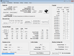
This utility can do the following:
- analyzing your flight from departure to your destination, and the landing with a graphical landingchart.
- when flight analysis is finished you can print a report, the report is automaticly saved as pdf File.
- quickly change the settings of FSX, such as time, date, fuel, weight, traffic etc.
- start a failure sytem, such as gear, flaps, engine, etc.
- runway detecting system to see wich runways are in use.
- load a existing flight or flightplan.
- quickly look to your CFG (settings) files and change them even before the flight simulator is running.
- after a flight is finished FsQC saves your flight automaticly as 'FsQC last Flight', so you can continue the next day or hour.
- and lots of more.
- see also http://www.fsqc.eu for more info.
- FSUIPC required
| Filename: | FSXFS2004_Flight_Analyzer_Utility.zip |
| License: | Check within download |
| Added: | 15th February 2018, 00:57:20 |
| Downloads: | 178 |
| Author: | Evander Tholen |
| Size: | 831 KB |
| Category: Flight Simulator X - AFCAD Files | |
| DABB - Rabah Bitat Airport - Annaba, Algeria |
|
Images related to this file:
File Description:
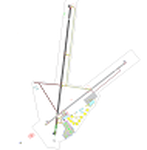
Rabah Bitat Airport (IATA: AAE, ICAO: DABB), formerly known as Les Salines Airport, and popularly as El Mellah Airport is an international airport located 9 km south of Annaba, a city in Algeria. It is named after Rabah Bitat, a president of Algeria (1978-1979). A new terminal is currently under construction which will help increase passenger capacity and replace the outdated current main terminal building. The airport is served by Air Algerie, Aigle Azur and Tassili Airlines.
Features:
*Expanded parking apron
*Taxiways properly designated and aligned
*Runway markings and lighting corrected
*Parking spots for commercial traffic
*Separate parking area for GA traffic
*Misc airport buildings added
*Construction of new terminal with cranes and construction vehicle and objects
*Airport vehicles and objects throughout the airport
*Fuel service vehicles
*Static aircraft
| Filename: | DABB__Rabah_Bitat_Airport__Annaba_Algeria.zip |
| License: | Freeware |
| Added: | 7th February 2014, 06:15:01 |
| Downloads: | 593 |
| Author: | Jaison Diaz / Endeavour ai |
| Size: | 71.41 KB |
| Category: Flight Simulator 2002 - Flight Plans | |
| 49RTWest |
|
File Description:
An FS2002 GPS flight Plan by the Ancient Brit. The 49th in a series of Round the World flight plans for the FS2002 default scenery. Depart Southend (EGMC) runway 24, UK and arrive 1 hour 54 minutes later at Stornoway (EGPO) runway 36, Scotland. Following a low level pass over London Town to see the sights, Heathrow is viewed on the way to Windsor Castle where the climb to cruise begins. An early descent for a low level tour of the Inner Hebrides with a chance to see that most rare and endangered animal, The Lesser Spotted Haggis, finishes with a VFR finals (Handholding instructions given).. The flight briefing (Word and text) is for the default B737-400; it contains climb, cruise, top of descent and fuel loading details, waypoint timings and destination details.
| Filename: | 49RTWest.zip |
| License: | Freeware |
| Added: | 26th February 2003, 22:44:58 |
| Downloads: | 740 |
| Author: | Denis Egan |
| Size: | 28.27 KB |
| Category: X-Plane - Scenery | |
| Heavy Delta Bomber for X-Plane 6.40/6.51 |
|
File Description:
The Heavy Delta Bomber is a mythical mach 3.25 bomber (level at 35500 ft.). With a GW of over 550,000 lb. and 3 engines with 60,000 lb. of thrust it can deliver big payloads, in a big hurry, and from long range. Built for speed its operating altitude is limited to 58,000 feet due to its high stall speed at altitude. Its long fuselage allows for big weapons and fuel capacity without external hard points. With approximately the same gross wt. and thrust of the XB-70 Valkyrie it is faster aven at 490,000 lb. The plane is very stable and easy to fly at all altitudes up to about 58000 feet. Do not get this plane into a spin or you have an out of control broom on your hands.
| Filename: | Heavy_Delta_Bomber_for_XPlane_640651.zip |
| License: | Freeware, limited distribution |
| Added: | 8th February 2003, 05:58:34 |
| Downloads: | 312 |
| Author: | Robert App |
| Size: | 414.87 KB |
| Category: Flight Simulator 2002 - Flight Plans | |
| Concorde flightplans In LAT/LONG Format For INS System Users |
|
File Description:
This file is an update to my earlier file 'ins_conc_flts.zip'. They are aimed at Concorde simmers who navigate using an INS system. I have incorporated the following improvements over my first release:
A few small route errors ironed out.
A new arrival as currently used for the EGLL-KJFK route.
Some more info about flying Concorde as per real-life procedures.
Distances between waypoints included in most plans so it will be easy to check that the coordinates have been entered correctly, and a clearer layout to the coordinates themselves.
A bit more info in the notes about each flight such as: fuel load required, geographical routing description where appropriate, expected approximate flight time, a guide to when to commence deceleration and subsequent descent, things to just make them generally more 'user friendly'.
| Filename: | Concorde_flightplans_In_LATLONG_Format_For_INS_System_Users.zip |
| License: | Freeware |
| Added: | 11th July 2003, 14:02:45 |
| Downloads: | 1,534 |
| Author: | Geoff Harrison |
| Size: | 18.31 KB |


© 2001-2026 AVSIM Online
All Rights Reserved
Privacy Policy |