
Where Flight Simulation Enthusiasts Gather from Around the World!
AVSIM Library - Search Results

| Category: Flight Simulator 2002 - AI Flight Plans | |
| Project Airlift 305th Air Mobility Wing #1 |

|
File Description:
This file contains fictional yet "realistic" flightplans for the 2nd and 32st Air Mobility Squadrons who fly a total of 32 KC-10s out of McGuire AFB in New Jersey. Destinations include many airbases throughout the New England area as well as bases in Canada, Iceland, UK, the Persian Gulf, Japan and many other locales. Each aircraft is static one day per week to simulate downtime for regular maintenance. It is recommended that you download any AFCAD files by Project Airlift as they provide a great foundation for the flight plans and other AFCADs that will continue to be developed in the future.
| Filename: | Project_Airlift_305th_Air_Mobility_Wing_1.zip |
| License: | Freeware |
| Added: | 7th January 2003, 14:09:43 |
| Downloads: | 1,440 |
| Author: | Joe Sumrall / Michael Hartshorn |
| Size: | 8.91 KB |
| Category: Flight Simulator X - AFCAD Files | |
| Hartung Airport (2NJ5), NJ |
|
File Description:
Located 02 miles S of Phillipsburg, New Jersey on 8 acres of land, Hartung Airport is a private turf strip. No transient services are offered. Trees are summertime ONLY.
Scenery constructed with use of satellite images/streetview, the author has not been there in person.
This scenery is meant to be used in conjunction with MegaScenery Earth New York 007. It is not required, but apron use is minimized to allow satellite scenery to show through as much as possible, and objects are placed based on the MSE textures - lack of it may make scenery look out of place.
| Filename: | Hartung_Airport_2NJ5_NJ.zip |
| License: | Freeware |
| Added: | 29th October 2010, 16:10:12 |
| Downloads: | 178 |
| Author: | Drew Sikora |
| Size: | 247.8 KB |
| Category: Flight Simulator 2004 - Scenery | |
| New Terrain Mesh of the Province of Quebec in LOD09 (1/4) |
|
File Description:
The files in this package contain terrain mesh files of the province of Quebec (N45 to N53) to be used with my Quebec enhanced sceneries for FS2004 (Scenes_du_Quebec_2k4.zip). The public data sources are the Shuttle Radar Topography Mission (SRTM-3, 90m) and the Canadian Digital Elevation Data (CDED - 0.75s/arc - 23m). (QC09_2k4a.zip to QC09_2k4d.zip - 4 parts)
***********************
Les fichiers de ces archives contiennent les donnees d'elevation de terrain (mesh files - lod09), pour FS2004, du territoire de la province de Quebec sous le 53ieme degre de latitude nord. Ils ont ete crees pour etre utilises avec mes nouvelles scenes du Quebec contenues dans Scenes_du_Quebec_2k4.zip. Les donnees sources sont du domaine public et proviennent de la Shuttle Radar Topography Mission (SRTM-3, 90m) et des donnees numerique d'elevation du Canada (DNEC - 0.75s/arc -23 m). (QC09_2k4a.zip to QC09_2k4d.zip - 4 parties)
| Filename: | New_Terrain_Mesh_of_the_Province_of_Quebec_in_LOD09_14.zip |
| License: | Freeware, limited distribution |
| Added: | 27th January 2010, 18:10:18 |
| Downloads: | 8,915 |
| Author: | Gilles Gauthier |
| Size: | 23.76 MB |
| Category: Flight Simulator 2004 - Scenery | |
| New Terrain Mesh of the Province of Quebec in LOD09 (2/4) |
|
File Description:
The files in this package contain terrain mesh files of the province of Quebec (N45 to N53) to be used with my Quebec enhanced sceneries for FS2004 (Scenes_du_Quebec_2k4.zip). The public data sources are the Shuttle Radar Topography Mission (SRTM-3, 90m) and the Canadian Digital Elevation Data (CDED - 0.75s/arc - 23m). (QC09_2k4a.zip to QC09_2k4d.zip - 4 parts)
***********************
Les fichiers de ces archives contiennent les donnees d'elevation de terrain (mesh files - lod09), pour FS2004, du territoire de la province de Quebec sous le 53ieme degre de latitude nord. Ils ont ete crees pour etre utilises avec mes nouvelles scenes du Quebec contenues dans Scenes_du_Quebec_2k4.zip. Les donnees sources sont du domaine public et proviennent de la Shuttle Radar Topography Mission (SRTM-3, 90m) et des donnees numerique d'elevation du Canada (DNEC - 0.75s/arc -23 m). (QC09_2k4a.zip to QC09_2k4d.zip - 4 parties)
| Filename: | New_Terrain_Mesh_of_the_Province_of_Quebec_in_LOD0.zip |
| License: | Freeware, limited distribution |
| Added: | 1st November 2009, 06:47:09 |
| Downloads: | 4,627 |
| Author: | Gilles Gauthier |
| Size: | 27.78 MB |
| Category: Flight Simulator 2004 - Scenery | |
| New Terrain Mesh of the Province of Quebec in LOD09 (3/4) |
|
File Description:
The files in this package contain terrain mesh files of the province of Quebec (N45 to N53) to be used with my Quebec enhanced sceneries for FS2004 (Scenes_du_Quebec_2k4.zip). The public data sources are the Shuttle Radar Topography Mission (SRTM-3, 90m) and the Canadian Digital Elevation Data (CDED - 0.75s/arc - 23m). (QC09_2k4a.zip to QC09_2k4d.zip - 4 parts)
***********************
Les fichiers de ces archives contiennent les donnees d'elevation de terrain (mesh files - lod09), pour FS2004, du territoire de la province de Quebec sous le 53ieme degre de latitude nord. Ils ont ete crees pour etre utilises avec mes nouvelles scenes du Quebec contenues dans Scenes_du_Quebec_2k4.zip. Les donnees sources sont du domaine public et proviennent de la Shuttle Radar Topography Mission (SRTM-3, 90m) et des donnees numerique d'elevation du Canada (DNEC - 0.75s/arc -23 m). (QC09_2k4a.zip to QC09_2k4d.zip - 4 parties)
| Filename: | New_Terrain_Mesh_of_the_Province_of_Quebec_in_LOD0.zip |
| License: | Freeware, limited distribution |
| Added: | 27th January 2010, 18:15:12 |
| Downloads: | 7,495 |
| Author: | Gilles Gauthier |
| Size: | 29.35 MB |
| Category: Flight Simulator 2004 - Scenery | |
| New Terrain Mesh of the Province of Quebec in LOD09 (4/4) |
|
File Description:
The files in this package contain terrain mesh files of the province of Quebec (N45 to N53) to be used with my Quebec enhanced sceneries for FS2004 (Scenes_du_Quebec_2k4.zip). The public data sources are the Shuttle Radar Topography Mission (SRTM-3, 90m) and the Canadian Digital Elevation Data (CDED - 0.75s/arc - 23m). (QC09_2k4a.zip to QC09_2k4d.zip - 4 parts)
***********************
Les fichiers de ces archives contiennent les donnees d'elevation de terrain (mesh files - lod09), pour FS2004, du territoire de la province de Quebec sous le 53ieme degre de latitude nord. Ils ont ete crees pour etre utilises avec mes nouvelles scenes du Quebec contenues dans Scenes_du_Quebec_2k4.zip. Les donnees sources sont du domaine public et proviennent de la Shuttle Radar Topography Mission (SRTM-3, 90m) et des donnees numerique d'elevation du Canada (DNEC - 0.75s/arc -23 m). (QC09_2k4a.zip to QC09_2k4d.zip - 4 parties)
| Filename: | New_Terrain_Mesh_of_the_Province_of_Quebec_in_LOD0.zip |
| License: | Freeware, limited distribution |
| Added: | 27th January 2010, 18:17:08 |
| Downloads: | 7,854 |
| Author: | Gilles Gauthier |
| Size: | 20.94 MB |
| Category: Flight Simulator 2004 - AI Aircraft | |
| Allegheny Commuter De Havilland Canada DHC-7 |
|
File Description:
Allegheny Commuter repaint for the DeHavilland Dash 7 model by Dee Waldron. For use with Southern Jersey Airways/Allegheny Commuter flight plans from Retro AI Traffic Group. Textures only. Tested in FS2002 also. See readme files for additional information. Click on Zipdrive for screen shot.
| Filename: | Allegheny_Commuter_De_Havilland_Canada_DHC7.zip |
| License: | Freeware |
| Added: | 2nd August 2005, 02:48:10 |
| Downloads: | 719 |
| Author: | Sheppard Avery / Dee Waldron |
| Size: | 609.71 KB |
| Category: Flight Simulator 2004 - Scenery | |
| Tibet Scenery v9.0 |
|
File Description:
Addon scenery for Microsoft Flight Simulators FS2004 both missing airports in Tibet
- ZULS LXA Lhasa Gongkar Airport (other names: Gonggar, Gonga)
- ZUBD BPX Changdu International Airport (other names: Bangda, Bamda, Pomda, Qamdo)
Includes now Potala Palace, seasonal textures and new terminal at Lhasa, corrected river and mesh and 3 detailed flightplans. AFCAD files available later after the release of the new AFCAD program.
By UranusJay - Jan Martin
| Filename: | Tibet_Scenery_v90.zip |
| License: | Freeware |
| Added: | 19th August 2003, 01:09:08 |
| Downloads: | 4,020 |
| Author: | Jan Martin |
| Size: | 863.35 KB |
| Category: Flight Simulator X - Scenery | |
| Millau Viaduct Bridge Patch |
|
File Description:
Patch for scenery Millau Viaduct Bridge.
In order to obtain a better adaptation of the viaduct with the ground, this archive contains three choices, according to the installed add-ons in your Scenery library:
options-1 Without UTX Europe and with Mesh France of France VFR. Option-2 With UTX Europe without Mesh France of France VFR.
Option-3 Without UTX Europe and Without Mesh France of France VFR.
The scenery " millau_Viaduct_FSX.zip " is needed. Download on AVSIM File Library.
| Filename: | Millau_Viaduct_Bridge_Patch.zip |
| License: | Freeware, limited distribution |
| Added: | 31st March 2008, 17:54:03 |
| Downloads: | 4,337 |
| Author: | Jean-Claude Irle |
| Size: | 11.23 KB |
| Category: Flight Simulator 2004 - Scenery | |
| Himalayas LOD9 Base Mesh, Volume 2 - Southcentral Ranges |
|
Images related to this file:
File Description:
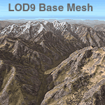
Detailed terrain mesh of the Southcentral Himalayan Ranges, N26-32 E82-90. The files in this package are based on Shuttle Radar (SRTM) Version 2 data but with many of the void areas, especially the most significant sections, filled with elevation data generated from topographic maps by Jonathan de Ferranti. While Jonathan's work is unrelated to flight simulation he kindly gave me permission to compile his data for use in FS. The result is a wonderful improvement in detail and accuracy over any existing mesh file, freeware or commercial, based on SRTM or DTED data alone.
Due to the large area of the Himalayas I've compiled the source data as two separate series: the "Himalayan Peaks" series covers prominent mountains and ranges in higher detail and locally overrides any existing LOD9 terrain mesh. In addition, a LOD9 "base mesh" series, with LOD8 and LOD7 "buffer" mesh files, covering the entire Himalayas, is meant for those who do not yet have an add-on terrain mesh of these beautiful mountains.
| Filename: | Himalayas_LOD9_Base_Mesh_Volume_2__Southcentral_Ra.zip |
| License: | Freeware, limited distribution |
| Added: | 29th May 2010, 09:05:56 |
| Downloads: | 9,447 |
| Author: | Holger Sandmann, Jonathan de Ferranti |
| Size: | 90.25 MB |
© 2001-2026 AVSIM Online
All Rights Reserved
Privacy Policy |