
Where Flight Simulation Enthusiasts Gather from Around the World!
AVSIM Library - Search Results

| Category: Flight Simulator X - Scenery | |
| Joinville, Brazil SBSV Photoreal Part1 |

|
File Description:
Joinville, is a Brazilian municipality located in the northeastern state of Santa Catarina, with 1130.878 km �² and has a population of 515,250 inhabitants in 2010 [3]. Largest municipality of Santa Catarina, and the third in the South, is also the headquarters of the micro-region of Joinville, Santa Catarina the Greater Region and Northern Metropolitan Region North / Northeast of Santa Catarina (along with Araquari). Its metropolitan area, comprising the counties adjacent to each other that form the Metropolitan North / Northeast of Santa Catarina, has about 1,094,570 inhabitants
| Filename: | Joinville_Brazil_SBSV_Photoreal_Part1.zip |
| License: | Freeware |
| Added: | 18th January 2012, 23:22:30 |
| Downloads: | 4,546 |
| Author: | Paulo Ricardo RubensGons |
| Size: | 244.87 MB |
| Category: Flight Simulator X - AFCAD Files | |
| Salem Airfield Airport (NJ74), NJ |
|
File Description:
Located 01 miles E of Salem, New Jersey on 14 acres of land, Salem Airfield is a private turf strip 2200' in length. The hard surface runway has been removed so have your mesh settings as high as possible to get the most out of landing/taking off on actual terrain. The surrounding area has been highly detailed with as much forestation as possible included to block out the horizon as much as possible considering the many open spaces surrounding the airport. Tie downs are located next to the middle of the runway, look for the marker cones or start in any RAMP_GA_SMALL parking locations. A hangar is available as well, and attendant is on call on NAV2 to open the door. You can start inside the hangar in the DOCK_GA parking spot or outside the hangar in the RAMP_GA parking spot. All parking is for aircraft with wingspans no greater than 40 feet. There is no fuel available. The field is lit for night use, but the windsock is not so check your weather before flying in!
Scenery constructed with use of satellite images/streetview/aerial photos - the author has not been there in person.
This scenery is meant to be used in conjunction with MegaScenery Earth New Jersey/Delaware 004. It is not required, but apron use is minimized to allow satellite scenery to show through as much as possible, and objects are placed based on the MSE textures - lack of it may make scenery look out of place.
| Filename: | Salem_Airfield_Airport_NJ74_NJ.zip |
| License: | Freeware |
| Added: | 10th August 2011, 02:05:51 |
| Downloads: | 176 |
| Author: | Drew Sikora |
| Size: | 910.96 KB |
| Category: Flight Simulator 2004 - Scenery | |
| Middle East SRTM Mesh - Lebanon, Israel and Egypt Part2 |
|
File Description:
Middle East SRTM Mesh - Lebanon, Israel and most of Egypt LOD9 Terrain Mesh in 3 parts, created from SRTM 3arc sec spatial data - this is Part 2. Mesh covers area from N25 - N34 and E29 - E36. It gives You possibility to fly above continuous terrain of Lebanon, Israel and Egypt. Holes were cleared using SRTM/DTED0 merger by Martin Domig, MICRODEM and SRTMFill.
| Filename: | Middle_East_SRTM_Mesh__Lebanon_Israel_and_Egypt_Pa.zip |
| License: | Freeware, limited distribution |
| Added: | 23rd April 2004, 12:55:58 |
| Downloads: | 6,640 |
| Author: | Ryszard Winawer |
| Size: | 21.07 MB |
| Category: Flight Simulator 2004 - Scenery | |
| Hauraki Gulf v4 |
|
File Description:
This replaces all my previous Pakatoa Island and Hauraki Gulf sceneries.You must have Christian Stock's NZ mesh in the form of "Mountains of New Zealand" and topo in the form of "Lakes and Rivers of New Zealand". Includes all previous scenery candy. New in this pack...RANGITOTO ISLAND: Rangitoto Lighthouse; Rangitoto Wharf, public conveniences and baches; Islington Bay Wharf with toilets, telephone and information stand.
| Filename: | Hauraki_Gulf_v4.zip |
| License: | Freeware |
| Added: | 9th November 2008, 08:12:31 |
| Downloads: | 298 |
| Author: | Godfrey Tier |
| Size: | 6 MB |
| Category: Flight Simulator 2004 - Scenery | |
| Fertiliser Works - Awatoto, Napier |
|
File Description:
Situated on the coast, just south of Napier - a familiar sight to pilots around Hawke's Bay, New Zealand.
An updated version from my original scenery object - textures also updated.
Smoke from chimneys affected by wind.
This scenery is located for Christian Stock's NZ mesh in the form of "Mountains of New Zealand" and topo in the form of "Lakes and Rivers of New Zealand".
| Filename: | Fertiliser_Works__Awatoto_Napier.zip |
| License: | Freeware |
| Added: | 28th October 2008, 14:20:16 |
| Downloads: | 376 |
| Author: | Godfrey Tier |
| Size: | 134.6 KB |
| Category: Flight Simulator 2004 - Scenery | |
| Hauraki Gulf v5 |
|
File Description:
This replaces all my previous Pakatoa Island and Hauraki Gulf sceneries.You must have Christian Stock's NZ mesh in the form of "Mountains of New Zealand" and topo in the form of "Lakes and Rivers of New Zealand". Includes all previous scenery candy. New in this version: MOTUTAPU ISLAND: Home Bay Wharf; WW2 Observation Hut, Billy Goat Point; Motutapu Outdoor Education Camp Trust, Administration Bay.
| Filename: | Hauraki_Gulf_v5.zip |
| License: | Freeware |
| Added: | 13th November 2008, 02:24:13 |
| Downloads: | 510 |
| Author: | Godfrey Tier |
| Size: | 6.4 MB |
| Category: Flight Simulator 2004 - AI Flight Plans | |
| Air Tahiti Nui (French Polynesia) Summer '05 |
|
File Description:
Summer 2005 schedules tested on FS2004. Includes 64 weekly flights for 5 aircraft (Airbus A340-300). Flightplans taken from the airline's website, 95%+ accurate. The new flights to New York & Sydney are included, as well as the 5th A343.
| Filename: | Air_Tahiti_Nui_French_Polynesia_Summer_05.zip |
| License: | Freeware |
| Added: | 13th June 2005, 03:00:44 |
| Downloads: | 956 |
| Author: | Carlos Augusto Narvaez Diaz |
| Size: | 2.78 KB |
| Category: Prepar3D V1-4 - Scenery | |
| ITALY ETM20m - Enhanced Terrain Mesh vol. 09 |
|
Images related to this file:
File Description:
Italy - ETM Enhanced Terrain Mesh 0.73 arc sec (20 meters). This Terrain Mesh is fully compatible with FSX/P3D (all versions). This is a work in progress. Volume 09 - Pianura Padano-Veneta (Padano - Veneto Plan)
| Filename: | ITALY_ETM20m__Enhanced_Terrain_Mesh_vol_09.zip |
| License: | Freeware |
| Added: | 23rd December 2018, 17:22:09 |
| Downloads: | 326 |
| Author: | Giovanni Miduri |
| Size: | 46.21 MB |
| Category: Flight Simulator 2004 - Scenery | |
| LOD 10 mesh terrain scenery of Slovenia, final version |
|
File Description:
Sampled to LOD10, this is a standard version of
mesh terrain covering N45E13 - N47E17.
It is perfectly compatible with Austria professional and mesh
of Italy by Pietro Mauri.All incompatibilities with flattens around
airports were corrected.
| Filename: | LOD_10_mesh_terrain_scenery_of_Slovenia_final_vers.zip |
| License: | Freeware |
| Added: | 13th November 2005, 23:09:48 |
| Downloads: | 6,279 |
| Author: | Mirko Ternik/FSSlovenia Team |
| Size: | 25.79 MB |
| Category: Flight Simulator 2004 - Original Aircraft | |
| Short S29 'Stirling' MkI |
|
Images related to this file:
File Description:
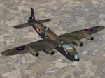
The second 4 engine bomber in RAF service.
Aircraft of 7 Sqdn. based at Oakington.
Recast with new Virtual Cockpit.
Ver.5, By Edward Cook [20/04/10]
| Filename: | Short__S29__Stirling__MkI.zip |
| License: | Freeware |
| Added: | 23rd April 2010, 20:01:02 |
| Downloads: | 1,223 |
| Author: | Edward Cook |
| Size: | 13.33 MB |
© 2001-2026 AVSIM Online
All Rights Reserved
Privacy Policy |